
McLean County, Illinois
Encyclopedia
McLean County is a county in the U.S. state
of Illinois
. McLean County is included in the Bloomington
–Normal
, Illinois
Metropolitan Statistical Area. According to the 2010 census, it has a population of 169,572, which is an increase of 12.7% from 150,433 in 2000. Its county seat
is Bloomington
.
Districts 4, 5, and 6 are within Normal limits while 7, 8, 9, and 10 are within Bloomington City Limits.
), not "mih-KLEEN" as some non-natives say.
. It was named for John McLean
, United States Senator for Illinois, who died in 1830.
As of the census
of 2000, there were 150,433 people, 56,746 households, and 35,466 families residing in the county. The population density
was 127 people per square mile (49/km²). There were 59,972 housing units at an average density of 51 per square mile (20/km²). The racial makeup of the county was 89.19% White
, 6.19% Black
or African American
, 0.16% Native American
, 2.05% Asian
, 0.03% Pacific Islander
, 1.01% from other races
, and 1.36% from two or more races. 2.55% of the population were Hispanic
or Latino
of any race. 30.6% were of German
, 11.5% Irish
, 9.1% English
and 9.0% American
ancestry according to Census 2000. 94.5% spoke English
and 2.5% Spanish
as their first language.
There were 56,746 households out of which 31.50% had children under the age of 18 living with them, 50.90% were married couples
living together, 8.80% had a female householder with no husband present, and 37.50% were non-families. 27.60% of all households were made up of individuals and 8.10% had someone living alone who was 65 years of age or older. The average household size was 2.45 and the average family size was 3.03.
In the county the population was spread out with 23.50% under the age of 18, 18.60% from 18 to 24, 29.20% from 25 to 44, 19.00% from 45 to 64, and 9.70% who were 65 years of age or older. The median age was 30 years. For every 100 females there were 93.60 males. For every 100 females age 18 and over, there were 90.40 males.
The median income for a household in the county was $47,021, and the median income for a family was $61,073. Males had a median income of $41,290 versus $28,435 for females. The per capita income
for the county was $22,227. About 4.10% of families and 9.70% of the population were below the poverty line, including 7.00% of those under age 18 and 5.00% of those age 65 or over.
 McLean County is divided into these townships
:
U.S. state
A U.S. state is any one of the 50 federated states of the United States of America that share sovereignty with the federal government. Because of this shared sovereignty, an American is a citizen both of the federal entity and of his or her state of domicile. Four states use the official title of...
of Illinois
Illinois
Illinois is the fifth-most populous state of the United States of America, and is often noted for being a microcosm of the entire country. With Chicago in the northeast, small industrial cities and great agricultural productivity in central and northern Illinois, and natural resources like coal,...
. McLean County is included in the Bloomington
Bloomington, Illinois
Bloomington is a city in McLean County, Illinois, United States and the county seat. It is adjacent to Normal, Illinois, and is the more populous of the two principal municipalities of the Bloomington-Normal metropolitan area...
–Normal
Normal, Illinois
Normal is an incorporated town in McLean County, Illinois, United States. It had a population of 52,497 as of the 2010 census. Normal is the smaller of two principal municipalities of the Bloomington-Normal metropolitan area...
, Illinois
Illinois
Illinois is the fifth-most populous state of the United States of America, and is often noted for being a microcosm of the entire country. With Chicago in the northeast, small industrial cities and great agricultural productivity in central and northern Illinois, and natural resources like coal,...
Metropolitan Statistical Area. According to the 2010 census, it has a population of 169,572, which is an increase of 12.7% from 150,433 in 2000. Its county seat
County seat
A county seat is an administrative center, or seat of government, for a county or civil parish. The term is primarily used in the United States....
is Bloomington
Bloomington, Illinois
Bloomington is a city in McLean County, Illinois, United States and the county seat. It is adjacent to Normal, Illinois, and is the more populous of the two principal municipalities of the Bloomington-Normal metropolitan area...
.
Government
McLean County has a 20 member board representing 10 districts within the County. District 1, District 2, and District 3 encompass all of the County save for the Bloomington/Normal metropolitan area.Districts 4, 5, and 6 are within Normal limits while 7, 8, 9, and 10 are within Bloomington City Limits.
Pronunciation
McLean is pronounced "mih-KLAIN" or "muh-KLAIN" (as with native son McLean StevensonMcLean Stevenson
Edgar McLean Stevenson, Jr. , better known as McLean Stevenson, was an American actor most recognized for his role as Lt. Colonel Henry Blake on the TV series M*A*S*H...
), not "mih-KLEEN" as some non-natives say.
History
McLean County was formed late in 1830 out of Tazewell CountyTazewell County, Illinois
Tazewell County is a county located in the U.S. state of Illinois. According to the 2010 census, it has a population of 135,394, which is an increase of 5.4% from 128,485 in 2000. Its county seat and largest city is Pekin. The majority of the population live in the suburbs and bedroom communities...
. It was named for John McLean
John McLean (Illinois politician)
John McLean was a United States Representative and a Senator from Illinois.Born near Guilford Court House , Guilford County, North Carolina, February 4, 1791, McLean moved with his parents to Logan County, Kentucky in 1795. He moved to Illinois Territory in 1815...
, United States Senator for Illinois, who died in 1830.
Demographics
As of the census
Census
A census is the procedure of systematically acquiring and recording information about the members of a given population. It is a regularly occurring and official count of a particular population. The term is used mostly in connection with national population and housing censuses; other common...
of 2000, there were 150,433 people, 56,746 households, and 35,466 families residing in the county. The population density
Population density
Population density is a measurement of population per unit area or unit volume. It is frequently applied to living organisms, and particularly to humans...
was 127 people per square mile (49/km²). There were 59,972 housing units at an average density of 51 per square mile (20/km²). The racial makeup of the county was 89.19% White
Race (United States Census)
Race and ethnicity in the United States Census, as defined by the Federal Office of Management and Budget and the United States Census Bureau, are self-identification data items in which residents choose the race or races with which they most closely identify, and indicate whether or not they are...
, 6.19% Black
Race (United States Census)
Race and ethnicity in the United States Census, as defined by the Federal Office of Management and Budget and the United States Census Bureau, are self-identification data items in which residents choose the race or races with which they most closely identify, and indicate whether or not they are...
or African American
Race (United States Census)
Race and ethnicity in the United States Census, as defined by the Federal Office of Management and Budget and the United States Census Bureau, are self-identification data items in which residents choose the race or races with which they most closely identify, and indicate whether or not they are...
, 0.16% Native American
Race (United States Census)
Race and ethnicity in the United States Census, as defined by the Federal Office of Management and Budget and the United States Census Bureau, are self-identification data items in which residents choose the race or races with which they most closely identify, and indicate whether or not they are...
, 2.05% Asian
Race (United States Census)
Race and ethnicity in the United States Census, as defined by the Federal Office of Management and Budget and the United States Census Bureau, are self-identification data items in which residents choose the race or races with which they most closely identify, and indicate whether or not they are...
, 0.03% Pacific Islander
Race (United States Census)
Race and ethnicity in the United States Census, as defined by the Federal Office of Management and Budget and the United States Census Bureau, are self-identification data items in which residents choose the race or races with which they most closely identify, and indicate whether or not they are...
, 1.01% from other races
Race (United States Census)
Race and ethnicity in the United States Census, as defined by the Federal Office of Management and Budget and the United States Census Bureau, are self-identification data items in which residents choose the race or races with which they most closely identify, and indicate whether or not they are...
, and 1.36% from two or more races. 2.55% of the population were Hispanic
Race (United States Census)
Race and ethnicity in the United States Census, as defined by the Federal Office of Management and Budget and the United States Census Bureau, are self-identification data items in which residents choose the race or races with which they most closely identify, and indicate whether or not they are...
or Latino
Race (United States Census)
Race and ethnicity in the United States Census, as defined by the Federal Office of Management and Budget and the United States Census Bureau, are self-identification data items in which residents choose the race or races with which they most closely identify, and indicate whether or not they are...
of any race. 30.6% were of German
Germans
The Germans are a Germanic ethnic group native to Central Europe. The English term Germans has referred to the German-speaking population of the Holy Roman Empire since the Late Middle Ages....
, 11.5% Irish
Irish people
The Irish people are an ethnic group who originate in Ireland, an island in northwestern Europe. Ireland has been populated for around 9,000 years , with the Irish people's earliest ancestors recorded having legends of being descended from groups such as the Nemedians, Fomorians, Fir Bolg, Tuatha...
, 9.1% English
English people
The English are a nation and ethnic group native to England, who speak English. The English identity is of early mediaeval origin, when they were known in Old English as the Anglecynn. England is now a country of the United Kingdom, and the majority of English people in England are British Citizens...
and 9.0% American
United States
The United States of America is a federal constitutional republic comprising fifty states and a federal district...
ancestry according to Census 2000. 94.5% spoke English
English language
English is a West Germanic language that arose in the Anglo-Saxon kingdoms of England and spread into what was to become south-east Scotland under the influence of the Anglian medieval kingdom of Northumbria...
and 2.5% Spanish
Spanish language
Spanish , also known as Castilian , is a Romance language in the Ibero-Romance group that evolved from several languages and dialects in central-northern Iberia around the 9th century and gradually spread with the expansion of the Kingdom of Castile into central and southern Iberia during the...
as their first language.
There were 56,746 households out of which 31.50% had children under the age of 18 living with them, 50.90% were married couples
Marriage
Marriage is a social union or legal contract between people that creates kinship. It is an institution in which interpersonal relationships, usually intimate and sexual, are acknowledged in a variety of ways, depending on the culture or subculture in which it is found...
living together, 8.80% had a female householder with no husband present, and 37.50% were non-families. 27.60% of all households were made up of individuals and 8.10% had someone living alone who was 65 years of age or older. The average household size was 2.45 and the average family size was 3.03.
In the county the population was spread out with 23.50% under the age of 18, 18.60% from 18 to 24, 29.20% from 25 to 44, 19.00% from 45 to 64, and 9.70% who were 65 years of age or older. The median age was 30 years. For every 100 females there were 93.60 males. For every 100 females age 18 and over, there were 90.40 males.
The median income for a household in the county was $47,021, and the median income for a family was $61,073. Males had a median income of $41,290 versus $28,435 for females. The per capita income
Per capita income
Per capita income or income per person is a measure of mean income within an economic aggregate, such as a country or city. It is calculated by taking a measure of all sources of income in the aggregate and dividing it by the total population...
for the county was $22,227. About 4.10% of families and 9.70% of the population were below the poverty line, including 7.00% of those under age 18 and 5.00% of those age 65 or over.
Geography
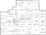
According to the 2010 census, the county has a total area of 1186.27 square miles (3,072.4 km²), of which 1183.38 square miles (3,064.9 km²) (or 99.76%) is land and 2.89 square miles (7.5 km²) (or 0.24%) is water.Townships
Township (United States)
A township in the United States is a small geographic area. Townships range in size from 6 to 54 square miles , with being the norm.The term is used in three ways....
:
|
Danvers Township, McLean County, Illinois Danvers Township is located in McLean County, Illinois. The population was 1,953 at the 2000 census.-External links:* * * *... Dawson Township, McLean County, Illinois Dawson Township is located in McLean County, Illinois. The population was 668 at the 2000 census. Dawson Township was originally named Lee Township, but changed to Padua Township on May 17, 1858, and then to Dawson on an unknown date.... Downs Township, McLean County, Illinois Downs Township is located in McLean County, Illinois. The population was 1,079 at the 2000 census. Downs Township was originally named Savanna Township, but it was changed on May 17, 1858.- External links :***... Dry Grove Township, McLean County, Illinois Dry Grove Township is located in McLean County, Illinois. The population was 1,649 at the 2000 census.- External links :***... Empire Township, McLean County, Illinois Empire Township is located in McLean County, Illinois. The population was 3,845 at the 2000 census. Empire Township changed its name from Le Roy Township on May 17, 1858.- External links :***... Funk’s Grove Township, McLean County, Illinois Funk's Grove Township is located in McLean County, Illinois. The population was 293 at the 2000 census.- External links :***... Gridley Township, McLean County, Illinois Gridley Township is located in McLean County, Illinois. The population was 1,914 at the 2000 census.- External links :***... Hudson Township, McLean County, Illinois Hudson Township is located in McLean County, Illinois. The population was 2,318 at the 2000 census.- External links :***... Lawndale Township, McLean County, Illinois Lawndale Township is located in McLean County, Illinois east of Lexington, northwest of Colfax, and southeast of Chenoa. The population was 227 at the 2000 census. Lawndale cemetery is located on 2550 North Road. At least part of the township is within the area of the proposed "Lexington Chenoa... Lexington Township, McLean County, Illinois Lexington Township is located in McLean County, Illinois. The population was 2,331 at the 2000 census.- External links :***... |
Martin Township, McLean County, Illinois Martin Township is located in McLean County, Illinois. The population was 1,229 at the 2000 census.- External links :***... Money Creek Township, McLean County, Illinois Money Creek Township is located in McLean County, Illinois. The population was 1,084 at the 2000 census.The American frontiersman and preserver of the buffalo, Charles "Buffalo" Jones, was reared at Money Creek during the 1850s.- External links :***... Mount Hope Township, McLean County, Illinois Mount Hope Township is located in McLean County, Illinois. The population was 1,172 at the 2000 census.- External links :***... Normal Township, McLean County, Illinois Normal Township is located in McLean County, Illinois. The population was 45,637 at the 2000 census.- External links :***... Old Town Township, McLean County, Illinois Old Town Township is located in McLean County, Illinois. The population was 2,692 at the 2000 census.- External links :***... Randolph Township, McLean County, Illinois Randolph Township is located in McLean County, Illinois. The population was 3,856 at the 2000 census.Randolph Township was named for Gardner Randolph, who settled in the area around 1832, near a thick grove of trees later referred to as Randolph's Grove.... Towanda Township, McLean County, Illinois Towanda Township is located in McLean County, Illinois. The population was 1,024 at the 2000 census. It contains the town of Towanda, Illinois.- External links :***... West Township, McLean County, Illinois West Township is located in McLean County, Illinois. The population was 278 at the 2000 census. West Township changed its name from Kickapoo Township on May 17, 1858.-External links:***... White Oak Township, McLean County, Illinois White Oak Township is located in McLean County, Illinois. The population was 807 at the 2000 census.- External links :***... Yates Township, McLean County, Illinois Yates Township is located in McLean County, Illinois. The population was 340 at the 2000 census. Yates Township formed as Union Township from Chenoa Township on June 5, 1862. Union was changed to Yates sometime prior to 1920.- External links :***... |
Cities and towns
|
Danvers, Illinois Danvers is a village in McLean County, Illinois, United States. The population was 1,154 at the 2010 census. It is part of the Bloomington–Normal Metropolitan Statistical Area.-Geography:Danvers is located at .... Downs, Illinois Downs is a village in McLean County, Illinois, United States. The population was 1,005 at the 2010 census. It is part of the Bloomington–Normal Metropolitan Statistical Area.-Geography:Downs is located at .... Ellsworth, Illinois Ellsworth is a village in Dawson Township, McLean County, Illinois, United States. The population was 195 at the 2010 Census. It is part of the Bloomington–Normal Metropolitan Statistical Area.-Geography:... Gridley, Illinois Gridley is a village in McLean County, Illinois, United States. The population was 1,432 at the 2010 census. It is part of the Bloomington–Normal Metropolitan Statistical Area.... Heyworth, Illinois Heyworth is a village in McLean County, Illinois, United States. It was founded in 1856. As of 2010, Heyworth has a population of 2,841. It is part of the Bloomington–Normal Metropolitan Statistical Area.-Geography:... Hudson, Illinois Hudson is a village in McLean County, Illinois, United States. The population was 1,838 at the 2010 census. It is part of the Bloomington–Normal Metropolitan Statistical Area.-Geography:Hudson is located at .... Le Roy, Illinois Le Roy is a city in McLean County, Illinois, United States. The population was 3,560 at the 2010 census.-Geography:Le Roy is located at .... Lexington, Illinois Lexington is a city in McLean County, Illinois, United States. The population was 2,060 at the 2010 census. There are two theories of its name. One says it was named for the Battle of Lexington, where General Gridley's father fought... |
Merna, Illinois Merna is an unincorporated community in McLean County, Illinois, United States. Merna is east-northeast of downtown Bloomington. Merna has a post office with ZIP code 61758.... McLean, Illinois McLean is a village in McLean County, Illinois, United States. The population was 830 at the 2010 census. It is part of the Bloomington–Normal Metropolitan Statistical Area.-Geography:McLean is located at .... Normal, Illinois Normal is an incorporated town in McLean County, Illinois, United States. It had a population of 52,497 as of the 2010 census. Normal is the smaller of two principal municipalities of the Bloomington-Normal metropolitan area... Saybrook, Illinois Saybrook is a village in southeast McLean County, Illinois, United States. The population was 693 at the 2010 census. It is part of the Bloomington–Normal Metropolitan Statistical Area.... Shirley, Illinois Shirley is a small unincorporated municipality located in southwestern McLean County. It sits right off Interstate 55. It was founded in 1854 and currently has a population of 378. Shirley is home to the Funk Prairie Home & Rock Museum.-History:... Stanford, Illinois Stanford is a village in McLean County, Illinois, United States. The population was 596 at the 2010 census. It is part of the Bloomington–Normal Metropolitan Statistical Area.-Geography:Stanford is located at .... Towanda, Illinois Towanda is a village in McLean County, Illinois, United States. The population was 480 at the 2010 census. It is part of the Bloomington–Normal Metropolitan Statistical Area.... |
Ghost towns
- BenjaminvilleBenjaminville, IllinoisThe village of Benjaminville, Illinois, was founded in McLean County, Illinois, United States during the 1850s by Quaker farmers, who, like many others who came to Illinois, were looking to take advantage of the rich prairie soil. The town's settlement centered around the Society of Friends and the...
- KumlerKumler, IllinoisKumler is a ghost town in West Township, McLean County, Illinois, USA.-External links:*...
- Allin, named for early pioneer James Allin, father of Dr. Lee Allin.
Adjacent counties
- Woodford County, IllinoisIllinoisIllinois is the fifth-most populous state of the United States of America, and is often noted for being a microcosm of the entire country. With Chicago in the northeast, small industrial cities and great agricultural productivity in central and northern Illinois, and natural resources like coal,...
to the northwest - Livingston CountyLivingston County, IllinoisLivingston County is a county located in the U.S. state of Illinois. According to the 2010 census, it has a population of 38,950, which is a decrease of 1.8% from 39,678 in 2000. Its county seat is Pontiac....
, IllinoisIllinoisIllinois is the fifth-most populous state of the United States of America, and is often noted for being a microcosm of the entire country. With Chicago in the northeast, small industrial cities and great agricultural productivity in central and northern Illinois, and natural resources like coal,...
to the northeast - Ford County, IllinoisIllinoisIllinois is the fifth-most populous state of the United States of America, and is often noted for being a microcosm of the entire country. With Chicago in the northeast, small industrial cities and great agricultural productivity in central and northern Illinois, and natural resources like coal,...
to the east - Champaign CountyChampaign County, IllinoisChampaign County is a county located in the U.S. state of Illinois. According to the 2010 census, it has a population of 201,081, which is an increase of 11.9% from 179,669 in 2000.. It is the 10th most populous county in Illinois...
, IllinoisIllinoisIllinois is the fifth-most populous state of the United States of America, and is often noted for being a microcosm of the entire country. With Chicago in the northeast, small industrial cities and great agricultural productivity in central and northern Illinois, and natural resources like coal,...
to the southeast - Piatt CountyPiatt County, IllinoisPiatt County is a county located in the U.S. state of Illinois. According to the 2010 census, it has a population of 16,729, which is an increase of 2.2% from 16,365 in 2000...
, IllinoisIllinoisIllinois is the fifth-most populous state of the United States of America, and is often noted for being a microcosm of the entire country. With Chicago in the northeast, small industrial cities and great agricultural productivity in central and northern Illinois, and natural resources like coal,...
to the south - DeWitt County, IllinoisIllinoisIllinois is the fifth-most populous state of the United States of America, and is often noted for being a microcosm of the entire country. With Chicago in the northeast, small industrial cities and great agricultural productivity in central and northern Illinois, and natural resources like coal,...
to the south - Logan CountyLogan County, IllinoisLogan County is a county located in the U.S. state of Illinois. According to the 2010 census, it has a population of 30,305, which is a decrease of 2.8% from 31,183 in 2000...
, IllinoisIllinoisIllinois is the fifth-most populous state of the United States of America, and is often noted for being a microcosm of the entire country. With Chicago in the northeast, small industrial cities and great agricultural productivity in central and northern Illinois, and natural resources like coal,...
to the southwest - Tazewell CountyTazewell County, IllinoisTazewell County is a county located in the U.S. state of Illinois. According to the 2010 census, it has a population of 135,394, which is an increase of 5.4% from 128,485 in 2000. Its county seat and largest city is Pekin. The majority of the population live in the suburbs and bedroom communities...
, IllinoisIllinoisIllinois is the fifth-most populous state of the United States of America, and is often noted for being a microcosm of the entire country. With Chicago in the northeast, small industrial cities and great agricultural productivity in central and northern Illinois, and natural resources like coal,...
to the west


 U.S. Highway 24
 U.S. Highway 51
 U.S. Highway 66
 U.S. Highway 136
 U.S. Highway 150


