
McIntosh County, Oklahoma
Encyclopedia
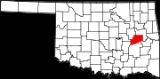
McIntosh County is a county located in the U.S. state
of Oklahoma
. As of 2000, the population was 19,456. Its county seat
is Eufaula
.
, the county has a total area of 1,845 km² (712 mi²). 1,606 km² (620 mi²) of it is land and 240 km² (92 mi²) of it (12.98%) is water.
of 2000, there were 19,456 people, 8,085 households, and 5,683 families residing in the county. The population density
was 12/km² (31/mi²). There were 12,640 housing units at an average density of 8/km² (20/mi²). The racial makeup of the county was 72.59% White
, 4.06% Black
or African American
, 16.20% Native American
, 0.14% Asian
, 0.03% Pacific Islander
, 0.35% from other races
, and 6.63% from two or more races. 1.27% of the population were Hispanic
or Latino
of any race. 96.4% spoke English
, 1.5% Muskogee and 1.5% Spanish
as their first language.
There were 8,085 households out of which 25.60% had children under the age of 18 living with them, 56.60% were married couples
living together, 10.40% had a female householder with no husband present, and 29.70% were non-families. 26.70% of all households were made up of individuals and 14.50% had someone living alone who was 65 years of age or older. The average household size was 2.37 and the average family size was 2.84.
In the county, the population was spread out with 22.60% under the age of 18, 6.40% from 18 to 24, 22.30% from 25 to 44, 26.90% from 45 to 64, and 21.80% who were 65 years of age or older. The median age was 44 years. For every 100 females there were 91.70 males. For every 100 females age 18 and over, there were 89.30 males.
The median income for a household in the county was $25,964, and the median income for a family was $31,990. Males had a median income of $27,998 versus $19,030 for females. The per capita income
for the county was $16,410. About 13.50% of families and 18.20% of the population were below the poverty line, including 24.80% of those under age 18 and 13.30% of those age 65 or over.
:
U.S. state
A U.S. state is any one of the 50 federated states of the United States of America that share sovereignty with the federal government. Because of this shared sovereignty, an American is a citizen both of the federal entity and of his or her state of domicile. Four states use the official title of...
of Oklahoma
Oklahoma
Oklahoma is a state located in the South Central region of the United States of America. With an estimated 3,751,351 residents as of the 2010 census and a land area of 68,667 square miles , Oklahoma is the 28th most populous and 20th-largest state...
. As of 2000, the population was 19,456. Its county seat
County seat
A county seat is an administrative center, or seat of government, for a county or civil parish. The term is primarily used in the United States....
is Eufaula
Eufaula, Oklahoma
Eufaula is a city in McIntosh County, Oklahoma, United States. The population was 2,639 at the 2000 census. It is the county seat of McIntosh County.-Geography:Eufaula is located at ....
.
Geography
According to the U.S. Census BureauUnited States Census Bureau
The United States Census Bureau is the government agency that is responsible for the United States Census. It also gathers other national demographic and economic data...
, the county has a total area of 1,845 km² (712 mi²). 1,606 km² (620 mi²) of it is land and 240 km² (92 mi²) of it (12.98%) is water.
Major highways
 Interstate 40
 U.S. Highway 69
 U.S. Highway 266
 State Highway 9State Highway 9 (Oklahoma)State Highway 9, abbreviated as SH-9, OK-9, or simply Highway 9, is a major east–west highway in the U.S. state of Oklahoma. Spanning across the central part of the state, SH-9 begins at the Texas state line near Madge, Oklahoma, and ends at the Arkansas state line near Fort Smith, Arkansas. State...
 State Highway 72
- Indian Nation TurnpikeIndian Nation TurnpikeThe Indian Nation Turnpike is a toll road in southeastern Oklahoma. It is the longest tollway in the state.-Route description:The Indian Nation turnpike is built to parkway-like design standards, omitting a center barrier and left-hand shoulders for a slightly mounded grassy median that is flush...
Adjacent counties
- Muskogee CountyMuskogee County, OklahomaMuskogee County is a county located in the U.S. state of Oklahoma. As of 2010, the population was 70,990. Its county seat is Muskogee.-Government:...
(north & east) - Haskell CountyHaskell County, OklahomaHaskell County is a county located in the southeast quadrant of the U.S. state of Oklahoma. As of 2000, the population was 11,792. Its county seat is Stigler. The county is named in honor of Charles N. Haskell, who was the first governor of Oklahoma....
(southeast) - Pittsburg CountyPittsburg County, OklahomaPittsburg County is a county located in the U.S. state of Oklahoma. As of 2000, the population was 43,953. Its county seat is McAlester.-Geography:According to the U.S. Census Bureau, the county has a total area of 3,569 km²...
(south) - Hughes CountyHughes County, OklahomaHughes County is a county located in the U.S. state of Oklahoma. As of 2000, the population was 14,154. Its county seat is Holdenville.-Geography:...
(southwest) - Okfuskee CountyOkfuskee County, OklahomaOkfuskee County is a county located in the U.S. state of Oklahoma. As of 2000, the population was 11,814. Its county seat is Okemah.-Geography:...
(west) - Okmulgee CountyOkmulgee County, OklahomaOkmulgee County is a county located in the U.S. state of Oklahoma. As of 2000, the population was 39,685. Its county seat is Okmulgee.-Geography:According to the U.S. Census Bureau, the county has a total area of 1,819 km²...
(northwest)
Demographics
As of the censusCensus
A census is the procedure of systematically acquiring and recording information about the members of a given population. It is a regularly occurring and official count of a particular population. The term is used mostly in connection with national population and housing censuses; other common...
of 2000, there were 19,456 people, 8,085 households, and 5,683 families residing in the county. The population density
Population density
Population density is a measurement of population per unit area or unit volume. It is frequently applied to living organisms, and particularly to humans...
was 12/km² (31/mi²). There were 12,640 housing units at an average density of 8/km² (20/mi²). The racial makeup of the county was 72.59% White
Race (United States Census)
Race and ethnicity in the United States Census, as defined by the Federal Office of Management and Budget and the United States Census Bureau, are self-identification data items in which residents choose the race or races with which they most closely identify, and indicate whether or not they are...
, 4.06% Black
Race (United States Census)
Race and ethnicity in the United States Census, as defined by the Federal Office of Management and Budget and the United States Census Bureau, are self-identification data items in which residents choose the race or races with which they most closely identify, and indicate whether or not they are...
or African American
Race (United States Census)
Race and ethnicity in the United States Census, as defined by the Federal Office of Management and Budget and the United States Census Bureau, are self-identification data items in which residents choose the race or races with which they most closely identify, and indicate whether or not they are...
, 16.20% Native American
Race (United States Census)
Race and ethnicity in the United States Census, as defined by the Federal Office of Management and Budget and the United States Census Bureau, are self-identification data items in which residents choose the race or races with which they most closely identify, and indicate whether or not they are...
, 0.14% Asian
Race (United States Census)
Race and ethnicity in the United States Census, as defined by the Federal Office of Management and Budget and the United States Census Bureau, are self-identification data items in which residents choose the race or races with which they most closely identify, and indicate whether or not they are...
, 0.03% Pacific Islander
Race (United States Census)
Race and ethnicity in the United States Census, as defined by the Federal Office of Management and Budget and the United States Census Bureau, are self-identification data items in which residents choose the race or races with which they most closely identify, and indicate whether or not they are...
, 0.35% from other races
Race (United States Census)
Race and ethnicity in the United States Census, as defined by the Federal Office of Management and Budget and the United States Census Bureau, are self-identification data items in which residents choose the race or races with which they most closely identify, and indicate whether or not they are...
, and 6.63% from two or more races. 1.27% of the population were Hispanic
Race (United States Census)
Race and ethnicity in the United States Census, as defined by the Federal Office of Management and Budget and the United States Census Bureau, are self-identification data items in which residents choose the race or races with which they most closely identify, and indicate whether or not they are...
or Latino
Race (United States Census)
Race and ethnicity in the United States Census, as defined by the Federal Office of Management and Budget and the United States Census Bureau, are self-identification data items in which residents choose the race or races with which they most closely identify, and indicate whether or not they are...
of any race. 96.4% spoke English
English language
English is a West Germanic language that arose in the Anglo-Saxon kingdoms of England and spread into what was to become south-east Scotland under the influence of the Anglian medieval kingdom of Northumbria...
, 1.5% Muskogee and 1.5% Spanish
Spanish language
Spanish , also known as Castilian , is a Romance language in the Ibero-Romance group that evolved from several languages and dialects in central-northern Iberia around the 9th century and gradually spread with the expansion of the Kingdom of Castile into central and southern Iberia during the...
as their first language.
There were 8,085 households out of which 25.60% had children under the age of 18 living with them, 56.60% were married couples
Marriage
Marriage is a social union or legal contract between people that creates kinship. It is an institution in which interpersonal relationships, usually intimate and sexual, are acknowledged in a variety of ways, depending on the culture or subculture in which it is found...
living together, 10.40% had a female householder with no husband present, and 29.70% were non-families. 26.70% of all households were made up of individuals and 14.50% had someone living alone who was 65 years of age or older. The average household size was 2.37 and the average family size was 2.84.
In the county, the population was spread out with 22.60% under the age of 18, 6.40% from 18 to 24, 22.30% from 25 to 44, 26.90% from 45 to 64, and 21.80% who were 65 years of age or older. The median age was 44 years. For every 100 females there were 91.70 males. For every 100 females age 18 and over, there were 89.30 males.
The median income for a household in the county was $25,964, and the median income for a family was $31,990. Males had a median income of $27,998 versus $19,030 for females. The per capita income
Per capita income
Per capita income or income per person is a measure of mean income within an economic aggregate, such as a country or city. It is calculated by taking a measure of all sources of income in the aggregate and dividing it by the total population...
for the county was $16,410. About 13.50% of families and 18.20% of the population were below the poverty line, including 24.80% of those under age 18 and 13.30% of those age 65 or over.
Towns
- HannaHanna, OklahomaHanna is a town in McIntosh County, Oklahoma, United States. The population was 133 at the 2000 census.-Geography:Hanna is located at .According to the United States Census Bureau, the town has a total area of , all of it land....
- HitchitaHitchita, OklahomaHitchita is a town in McIntosh County, Oklahoma, United States. The population was 113 at the 2000 census.-Geography:Hitchita is located at .According to the United States Census Bureau, the town has a total area of , all of it land.-Demographics:...
- RentiesvilleRentiesville, OklahomaRentiesville is a town in McIntosh County, Oklahoma, United States. The population was 102 at the 2000 census.-Geography:Rentiesville is located at ....
- StidhamStidham, OklahomaStidham is a town in McIntosh County, Oklahoma, United States. The population was 23 at the 2000 census.-Geography:Stidham is located at .According to the United States Census Bureau, the town has a total area of , all of it land....
Census-designated places
- Duchess LandingDuchess Landing, OklahomaDuchess Landing is a census-designated place in McIntosh County, Oklahoma, United States. The population was 95 at the 2000 census.-Geography:Duchess Landing is located at ....
- Shady GroveShady Grove, McIntosh County, OklahomaShady Grove is a census-designated place in McIntosh County, Oklahoma, United States. The population was 185 at the 2000 census.-Geography:Shady Grove is located at ....
- TexannaTexanna, OklahomaTexanna is a census-designated place in McIntosh County, Oklahoma, United States. The population was 2,083 at the 2000 census.Established in District 12 of the old Indian Territory, its post office existed from June 27, 1888, until July 16, 1940. Texanna's population in the 1905 Territorial Census...
NRHP sites
The following sites in McIntosh County are listed on the National Register of Historic PlacesNational Register of Historic Places
The National Register of Historic Places is the United States government's official list of districts, sites, buildings, structures, and objects deemed worthy of preservation...
:
|
Oklahoma Odd Fellows Home at Checotah The Oklahoma Odd Fellows Home at Checotah is a historical building in Checotah, Oklahoma, central United States, built in 1902. It includes Romanesque Revival and Bungalow/Craftsman architecture. Also known as Odd Fellows Widows and Orphans Home and as Checotah Odd Fellows Home, it served... , Checotah |