
.gif)
State Highway 9 (Oklahoma)
Encyclopedia
State Highway 9, abbreviated as SH-9, OK-9, or simply Highway 9, is a major east–west highway in the U.S.
state of Oklahoma
. Spanning across the central part of the state, SH-9 begins at the Texas
state line near Madge, Oklahoma, and ends at the Arkansas
state line near Fort Smith, Arkansas
. State Highway 9 is a major highway around the Norman
area. At 350 miles (563.3 km), SH-9 is Oklahoma's second-longest state highway (second to State Highway 3
).
 From the western terminus at State Highway 203 along the Texas border, the highway travels due east for 5 miles (8 km) and intersects with SH-30
between Madge and Vinson
. SH-9 continues east for 23 miles (37 km) without intersecting another highway until meeting US-283/SH-34
, which is two miles (3 km) north of Mangum
. The highway overlaps the other two routes for four miles (6 km), going north, before splitting off and heading east again through Granite
and Lone Wolf
. Near Hobart
, SH-9 overlaps US-183 for 4 miles (6.4 km) (again going northward) before splitting off again.
Continuing east, SH-9 passes through Gotebo
, Mountain View
, and Carnegie
. Around Fort Cobb, Oklahoma
, the highway begins 9 miles (14.5 km) of travel to the south. There, the route links up with the concurrent U.S. Highways 62 and 281. While US-281 will split off in Anadarko
, SH-9 and US-62 remain concurrent until Newcastle
. In Chickasha
, US-277 joins to form another three-route concurrency with US-62 and SH-9. On the eastern edge of Chickasha, US-62/277/SH-9 have an interchange with I-44, or more commonly known as the H.E. Bailey Turnpike.
Traveling northeast from Chickasha, US-62/277/SH-9 are routed to the town of Blanchard
. Four miles later, SH-9 splits away from the two U.S. routes at a diamond interchange
that also serves as the eastern terminus of the H.E. Bailey Turnpike Spur. SH-9 remains without any concurrent routes until Goldsby
. The section of road east of US-62/277, recently upgraded to a four-lane divided highway, provides a link from the H.E. Bailey Turnpike Spur to Interstate 35. At the interstate, SH-9 merges onto I-35 northbound to cross the Canadian River
into Norman.
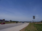
 Through Norman, Highway 9 serves as a major artery providing access to the University of Oklahoma
campus (in particular, the Lloyd Noble Center
). Around the area, the route is a four-lane divided highway (with surface crossings and stoplights). However, after a full interchange with US-77, the road becomes a two lane highway again.
SH-9 continues eastward, passing Lake Thunderbird
and the Little River Zoo, before reaching the towns of Tecumseh
and Seminole
. The road intersects the Indian Nation Turnpike
near Hanna
, and US-69 near Eufaula
. SH-9 provides access to the south side of Lake Eufaula
before reaching Stigler
.
SH-9 overlaps US-59 for 5 miles (8 km), after which the road becomes concurrent with US-271. Both remain concurrent, until the highway ends at the Arkansas border. After passing the Arkansas state line, State Highway 9 becomes I-540
, and US-271 continues over the state line concurrent with the Interstate.
 Officially designated on 1924-08-24, the original route encompassed all of current SH-9 west of Blanchard. East of Blanchard, SH-9 followed a more northerly route. Bypassing Norman, SH-9 ran north to Oklahoma City
before going east through Harrah
, Meeker
, Prague
, Henryetta
, and Checotah
. The highway ended at the original State Highway 3 in Spiro
. Upon the creation of the United States Numbered Routes system in 1926, the section between Oklahoma City and Warner was overlaid with U.S. Highway 266. Four years later in 1930, SH-9 was truncated to Chickasha. By this time, much of the route had become part of U.S. Highway 62.
On 1935-08-27, the route was extended eastward, taking over the original SH-37. SH-9's eastern terminus became SH-48 near Seminole
. On 1937-08-25, the route was brought further east to end at US-69 in Eufaula. Part of the newly commissioned section was rescinded on 1937-10-19, when a small segment just east of SH-48 and the entire Hughes County
portion were dropped from the highway. These sections were re-added on 1938-09-27.
State Highway 9 was extended eastward twice in the route's history. The first extension occurred on 1941-02-26, and extended SH-9 to SH-2 at Whitefield
. The final extension brought SH-9 to the Arkansas state line on 1941-11-12. The only major realignment in SH-9's history since 1941 was the Norman expressway bypass, which was designated as SH-9 on 1971-11-08.
After the I-40 bridge disaster, parts of State Highway 9 in eastern Oklahoma served as an emergency detour for eastbound I-40 traffic. All eastbound traffic was routed along the section of SH-9 between SH-2 in Whitefield and US-59. In addition, the section of SH-9 between US-59 and the Arkansas state line were used for eastbound traffic for commercial truck
s.
. ODOT criticized the city's plan as too expensive. The city is now proposing a compromise, with a narrower raised concrete median and separate bike path.
s, serving towns the main route bypasses. These routes are:

United States
The United States of America is a federal constitutional republic comprising fifty states and a federal district...
state of Oklahoma
Oklahoma
Oklahoma is a state located in the South Central region of the United States of America. With an estimated 3,751,351 residents as of the 2010 census and a land area of 68,667 square miles , Oklahoma is the 28th most populous and 20th-largest state...
. Spanning across the central part of the state, SH-9 begins at the Texas
Texas
Texas is the second largest U.S. state by both area and population, and the largest state by area in the contiguous United States.The name, based on the Caddo word "Tejas" meaning "friends" or "allies", was applied by the Spanish to the Caddo themselves and to the region of their settlement in...
state line near Madge, Oklahoma, and ends at the Arkansas
Arkansas
Arkansas is a state located in the southern region of the United States. Its name is an Algonquian name of the Quapaw Indians. Arkansas shares borders with six states , and its eastern border is largely defined by the Mississippi River...
state line near Fort Smith, Arkansas
Fort Smith, Arkansas
Fort Smith is the second-largest city in Arkansas and one of the two county seats of Sebastian County. With a population of 86,209 in 2010, it is the principal city of the Fort Smith, Arkansas-Oklahoma Metropolitan Statistical Area, a region of 298,592 residents which encompasses the Arkansas...
. State Highway 9 is a major highway around the Norman
Norman, Oklahoma
Norman is a city in Cleveland County, Oklahoma, United States, and is located south of downtown Oklahoma City. It is part of the Oklahoma City metropolitan area. As of the 2010 census, Norman was to have 110,925 full-time residents, making it the third-largest city in Oklahoma and the...
area. At 350 miles (563.3 km), SH-9 is Oklahoma's second-longest state highway (second to State Highway 3
State Highway 3 (Oklahoma)
State Highway 3, also abbreviated as SH-3 or OK-3, is a highway maintained by the U.S. state of Oklahoma. Traveling diagonally through Oklahoma, from the Panhandle to the far southeastern corner of the state, SH-3 is the longest state highway in the Oklahoma road system, at a total length of...
).
West of Interstate 35
State Highway 30 (Oklahoma)
State Highway 30 is a state highway in Oklahoma. It runs 84.5 miles south-to-north along the western edge of the state, from US-62 in Hollis to the town of Durham, two miles north of SH-33...
between Madge and Vinson
Vinson, Oklahoma
Vinson is an unincorporated community in Harmon County, Oklahoma, United States. The community was named for Henry B. Vinson, townsite owner. Although it is unincorporated, Vinson has a post office, which was established on August 20, 1903. It remains operational with the ZIP code of...
. SH-9 continues east for 23 miles (37 km) without intersecting another highway until meeting US-283/SH-34
State Highway 34 (Oklahoma)
State Highway 34 is a state highway in the U.S. state of Oklahoma. It runs for south-to-north in the western part of the state...
, which is two miles (3 km) north of Mangum
Mangum, Oklahoma
Mangum is a city in Greer County, Oklahoma, United States. The population was 3,010 at the 2010 census. It is the county seat of Greer County....
. The highway overlaps the other two routes for four miles (6 km), going north, before splitting off and heading east again through Granite
Granite, Oklahoma
Granite is a town in Greer County, Oklahoma, United States. The population was 1,065 at the 2010 census.-Geography:Granite is located at .According to the United States Census Bureau, the town has a total area of , all of it land....
and Lone Wolf
Lone Wolf, Oklahoma
Lone Wolf is a town in Kiowa County, Oklahoma, United States. The population was 438 at the 2010 census. The town was named for Chief Lone Wolf , a warrior chief of the Kiowa who fought to preserve his people's autonomy and way of life.-Geography:...
. Near Hobart
Hobart, Oklahoma
Hobart is a city in and the county seat of Kiowa County, Oklahoma, United States. Hobart was founded in 1901 on what had been part of an Indian reservation. The settlers drew lots for free land. It was named for Garret Hobart, the twenty-fourth Vice President of the United States. The population...
, SH-9 overlaps US-183 for 4 miles (6.4 km) (again going northward) before splitting off again.
Continuing east, SH-9 passes through Gotebo
Gotebo, Oklahoma
Gotebo is a town in Kiowa County, Oklahoma, United States. The population was 226 at the 2010 census.The town is named after the notable Kiowa Indian named Gotebo .-Geography:Gotebo is located at ....
, Mountain View
Mountain View, Oklahoma
Mountain View is a town in Kiowa County, Oklahoma, United States. The population was 795 at the 2010 census.-Geography:Mountain View is located at ....
, and Carnegie
Carnegie, Oklahoma
Carnegie is a town in Caddo County, Oklahoma, United States. The population was 1,723 at the 2010 census.-Geography:Carnegie is located at .According to the United States Census Bureau, the town has a total area of , all of it land....
. Around Fort Cobb, Oklahoma
Fort Cobb, Oklahoma
Fort Cobb is a town in Caddo County, Oklahoma, United States. The population was 667 at the 2000 census.-Geography:Fort Cobb is located at ....
, the highway begins 9 miles (14.5 km) of travel to the south. There, the route links up with the concurrent U.S. Highways 62 and 281. While US-281 will split off in Anadarko
Anadarko, Oklahoma
Anadarko is a city in Caddo County, Oklahoma, United States. The population was 6,645 at the 2000 census. It is the county seat of Caddo County.-Early History:Anadarko got its name when its post office was established in 1873...
, SH-9 and US-62 remain concurrent until Newcastle
Newcastle, Oklahoma
Newcastle is the largest city in McClain County, Oklahoma, United States, and a part of the Oklahoma City Metropolitan Area. The population was 7,685 at the 2010 census.-Geography:Newcastle is located at ....
. In Chickasha
Chickasha, Oklahoma
Chickasha is a city in and the county seat, business and employment center of Grady County, Oklahoma, United States. The population was 15,850 at the 2000 census. Chickasha is home to the University of Science and Arts of Oklahoma and hosts an annual Festival of Light celebration located at...
, US-277 joins to form another three-route concurrency with US-62 and SH-9. On the eastern edge of Chickasha, US-62/277/SH-9 have an interchange with I-44, or more commonly known as the H.E. Bailey Turnpike.
Traveling northeast from Chickasha, US-62/277/SH-9 are routed to the town of Blanchard
Blanchard, Oklahoma
Blanchard is a city in Grady and McClain counties in the U.S. state of Oklahoma. The population was 7,670 at the 2010 census. Blanchard is part of a rapidly growing area of northern McClain and Grady Counties known as the "Tri-City Area" with Newcastle and Tuttle.-Early history:Blanchard is...
. Four miles later, SH-9 splits away from the two U.S. routes at a diamond interchange
Diamond interchange
A diamond interchange is a common type of road junction, used where a freeway crosses a minor road. The freeway itself is grade-separated from the minor road, one crossing the other over a bridge...
that also serves as the eastern terminus of the H.E. Bailey Turnpike Spur. SH-9 remains without any concurrent routes until Goldsby
Goldsby, Oklahoma
Goldsby is a town in McClain County, Oklahoma, United States. The population was 1,204 at the 2000 census.-Geography:Goldsby is located at ....
. The section of road east of US-62/277, recently upgraded to a four-lane divided highway, provides a link from the H.E. Bailey Turnpike Spur to Interstate 35. At the interstate, SH-9 merges onto I-35 northbound to cross the Canadian River
Canadian River
The Canadian River is the longest tributary of the Arkansas River. It is about long, starting in Colorado and traveling through New Mexico, the Texas Panhandle, and most of Oklahoma....
into Norman.
East of Interstate 35
University of Oklahoma
The University of Oklahoma is a coeducational public research university located in Norman, Oklahoma. Founded in 1890, it existed in Oklahoma Territory near Indian Territory for 17 years before the two became the state of Oklahoma. the university had 29,931 students enrolled, most located at its...
campus (in particular, the Lloyd Noble Center
Lloyd Noble Center
The Lloyd Noble Center is an 11,528-seat multi-purpose arena, in Norman, Oklahoma, United States, some south of downtown Oklahoma City...
). Around the area, the route is a four-lane divided highway (with surface crossings and stoplights). However, after a full interchange with US-77, the road becomes a two lane highway again.
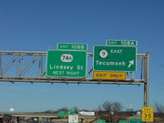
SH-9 continues eastward, passing Lake Thunderbird
Lake Thunderbird
Lake Thunderbird is a reservoir within the city limits of Norman, in the U.S. state of Oklahoma. The lake was constructed between 1962 and 1965 for the purpose of providing municipal water to nearby communities. It is formed by an earthfill embankment 7,300 feet long and up to high on the...
and the Little River Zoo, before reaching the towns of Tecumseh
Tecumseh, Oklahoma
Tecumseh is a city in Pottawatomie County, Oklahoma, United States. The population was 6,457 at the 2010 census.-Geography:Tecumseh is located at ....
and Seminole
Seminole, Oklahoma
Seminole is a city in Seminole County, Oklahoma, United States. The population was 6,899 at the 2000 census. Seminole experienced a large population growth in the 1920s due to an oil boom...
. The road intersects the Indian Nation Turnpike
Indian Nation Turnpike
The Indian Nation Turnpike is a toll road in southeastern Oklahoma. It is the longest tollway in the state.-Route description:The Indian Nation turnpike is built to parkway-like design standards, omitting a center barrier and left-hand shoulders for a slightly mounded grassy median that is flush...
near Hanna
Hanna, Oklahoma
Hanna is a town in McIntosh County, Oklahoma, United States. The population was 133 at the 2000 census.-Geography:Hanna is located at .According to the United States Census Bureau, the town has a total area of , all of it land....
, and US-69 near Eufaula
Eufaula, Oklahoma
Eufaula is a city in McIntosh County, Oklahoma, United States. The population was 2,639 at the 2000 census. It is the county seat of McIntosh County.-Geography:Eufaula is located at ....
. SH-9 provides access to the south side of Lake Eufaula
Lake Eufaula
Lake Eufaula may refer to:*Eufaula Lake, an artificial lake on the Canadian River in Oklahoma, USA*Walter F. George Lake, an artificial lake on the Chattahoochee River between Alabama and Georgia, USA that is also known known as Lake Eufaula, from the town of Eufaula, Alabama on its western banks...
before reaching Stigler
Stigler, Oklahoma
Stigler is a city in Haskell County, Oklahoma, United States. The population was 2,731 at the 2000 census. It is the county seat of Haskell County.-Geography:Stigler is located at...
.
SH-9 overlaps US-59 for 5 miles (8 km), after which the road becomes concurrent with US-271. Both remain concurrent, until the highway ends at the Arkansas border. After passing the Arkansas state line, State Highway 9 becomes I-540
Interstate 540 (Arkansas)
Interstate 540 in Arkansas is a spur of Interstate 40 between Fort Smith and Northwest Arkansas; the Northwest Arkansas segment is proposed to become part of an expanded Interstate 49. I-540 provides an Interstate Highway path between Fayetteville and Little Rock via Interstate 40. This links the...
, and US-271 continues over the state line concurrent with the Interstate.
History
Oklahoma city
Oklahoma City is the capital and largest city of the U.S. state of Oklahoma.Oklahoma City may also refer to:*Oklahoma City metropolitan area*Downtown Oklahoma City*Uptown Oklahoma City*Oklahoma City bombing*Oklahoma City National Memorial...
before going east through Harrah
Harrah, Oklahoma
Harrah is a city in Oklahoma County, Oklahoma, United States, and a part of the Oklahoma City metropolitan area. Located east of downtown Oklahoma City, Harrah had a population of 5,148 people as of 2009.-Geography:...
, Meeker
Meeker, Oklahoma
Meeker is a town in Lincoln County, Oklahoma, United States. The population was 978 at the 2000 census.-Geography:Meeker is located at ....
, Prague
Prague, Oklahoma
Prague is a city in Lincoln County, Oklahoma, United States. The population was 2,138 at the 2000 census.-Geography:Prague is located at .According to the United States Census Bureau, the city has a total area of , all of it land....
, Henryetta
Henryetta, Oklahoma
Henryetta is a city in Okmulgee County, Oklahoma, United States. The population was 6,096 at the 2000 census.Henryetta is notable as the high school hometown of NFL Hall of Fame quarterback Troy Aikman...
, and Checotah
Checotah, Oklahoma
Checotah is a city in McIntosh County, Oklahoma, United States. It was named for Samuel Checote, the first chief of the Creek Nation elected after the Civil War. The population was 3,481 at the 2000 census....
. The highway ended at the original State Highway 3 in Spiro
Spiro, Oklahoma
Spiro is a town in Le Flore County, Oklahoma, United States. It is part of the Fort Smith, Arkansas-Oklahoma Metropolitan Statistical Area. The population was 2,227 at the 2000 census.-Geography:Spiro is located at ....
. Upon the creation of the United States Numbered Routes system in 1926, the section between Oklahoma City and Warner was overlaid with U.S. Highway 266. Four years later in 1930, SH-9 was truncated to Chickasha. By this time, much of the route had become part of U.S. Highway 62.
On 1935-08-27, the route was extended eastward, taking over the original SH-37. SH-9's eastern terminus became SH-48 near Seminole
Seminole, Oklahoma
Seminole is a city in Seminole County, Oklahoma, United States. The population was 6,899 at the 2000 census. Seminole experienced a large population growth in the 1920s due to an oil boom...
. On 1937-08-25, the route was brought further east to end at US-69 in Eufaula. Part of the newly commissioned section was rescinded on 1937-10-19, when a small segment just east of SH-48 and the entire Hughes County
Hughes County, Oklahoma
Hughes County is a county located in the U.S. state of Oklahoma. As of 2000, the population was 14,154. Its county seat is Holdenville.-Geography:...
portion were dropped from the highway. These sections were re-added on 1938-09-27.
State Highway 9 was extended eastward twice in the route's history. The first extension occurred on 1941-02-26, and extended SH-9 to SH-2 at Whitefield
Whitefield, Oklahoma
Whitefield is a town in Haskell County, Oklahoma, United States. The population was 231 at the 2000 census.-Geography:Whitefield is located at...
. The final extension brought SH-9 to the Arkansas state line on 1941-11-12. The only major realignment in SH-9's history since 1941 was the Norman expressway bypass, which was designated as SH-9 on 1971-11-08.
After the I-40 bridge disaster, parts of State Highway 9 in eastern Oklahoma served as an emergency detour for eastbound I-40 traffic. All eastbound traffic was routed along the section of SH-9 between SH-2 in Whitefield and US-59. In addition, the section of SH-9 between US-59 and the Arkansas state line were used for eastbound traffic for commercial truck
Truck
A truck or lorry is a motor vehicle designed to transport cargo. Trucks vary greatly in size, power, and configuration, with the smallest being mechanically similar to an automobile...
s.
Future
Discussions are under way to widen SH-9 to four lanes east of US-77 in Norman. The City of Norman and ODOT have conflict in their proposals for the design of the widened highway. ODOT has proposed a 16 feet (4.9 m) paved median, with 12 feet (3.7 m) shoulders to accommodate bicyclists. Norman's proposal includes a grass median and a separate bike path along the north side of the right-of-way, running from 24th Avenue S.E. to Lake ThunderbirdLake Thunderbird
Lake Thunderbird is a reservoir within the city limits of Norman, in the U.S. state of Oklahoma. The lake was constructed between 1962 and 1965 for the purpose of providing municipal water to nearby communities. It is formed by an earthfill embankment 7,300 feet long and up to high on the...
. ODOT criticized the city's plan as too expensive. The city is now proposing a compromise, with a narrower raised concrete median and separate bike path.
Spurs
State Highway 9 creates three spur highways throughout the state. Additionally, it has two business routeBusiness route
A business route in the United States and Canada is a short special route connected to a parent numbered highway at its beginning, then routed through the central business district of a nearby city or town, and finally reconnecting with the same parent numbered highway again at its...
s, serving towns the main route bypasses. These routes are:
- Business SH-9, a three mile (5 km) loop through HobartHobart, OklahomaHobart is a city in and the county seat of Kiowa County, Oklahoma, United States. Hobart was founded in 1901 on what had been part of an Indian reservation. The settlers drew lots for free land. It was named for Garret Hobart, the twenty-fourth Vice President of the United States. The population...
. - Another instance of Business SH-9 that loops through GoteboGotebo, OklahomaGotebo is a town in Kiowa County, Oklahoma, United States. The population was 226 at the 2010 census.The town is named after the notable Kiowa Indian named Gotebo .-Geography:Gotebo is located at ....
. (This is not shown on the state highway map.)
- SH-9A is a designation for three distinct highways:
- A highway that intersects SH-9 in EarlsboroEarlsboro, OklahomaEarlsboro is a town in Pottawatomie County, Oklahoma, United States. The population was 633 at the 2000 census.-Geography:Earlsboro is located at ....
and links the parent highway to I-40 and SH-39State Highway 39 (Oklahoma)State Highway 39, abbreviated as SH-39 or OK-39, is a state highway in the U.S. state of Oklahoma. It is 68.4 miles in length. Built in 1923, it runs east–west through the central part of the state...
in KonawaKonawa, OklahomaKonawa is a city in Seminole County, Oklahoma, United States. The population was 1,479 at the 2000 census.-Geography:Konawa is located at . According to the United States Census Bureau, the city has a total area of , all of it land....
. The spur also passes through the town of MaudMaud, OklahomaMaud is a city in Pottawatomie and Seminole counties in the U.S. state of Oklahoma. The population was 1,048 at the 2010 census.-Geography:Maud is located at...
. - A connector highway from US-69 to SH-9 south of Eufaula.
- A spur route to SH-112 in ArkomaArkoma, OklahomaArkoma is a town in Le Flore County, Oklahoma, United States. It is part of the Fort Smith, Arkansas-Oklahoma Metropolitan Statistical Area. The population was 2,180 at the 2000 census...
. This section is a former alignment of U.S. Highway 271.
- A highway that intersects SH-9 in Earlsboro