
Matrei am Brenner
Encyclopedia
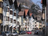
Matrei am Brenner is a small municipality in the southern part of the District Innsbruck-Land
and is located approximately 17 km south of Innsbruck
. Matrei has always been an important station for commerce. The village has 902 inhabitants
, at 992 m. above sea level and the Sill river
flows through it.
, the road branches off to the north, one follows the valley along the river to get to Innsbruck, the other on the eastern shore, with a more circuitous route through Patsch, Lans and Ampass, comes up to Hall in Tirol
. The first was the way, covered by the Germanic Sovereigns of the Holy Roman Empire
, through the Scharnitz pass, to Rome for the coronation
(1200 BC) as shown by the remains discovered in the area and by signs of Hallstatt culture
. In 1964 during work at "Gasthof Heisenstecken" a hundred urns were found. The Romans, in 200 A. D. about, built a rest site along the street as "locus Matreium" as mentioned in the Tabula Peutingeriana
. In 995 the village used the name "Matereia" and in 1251 was elevated to "Commune Market". The Diocese of Brixen in 1497, instituted the Court of Market that remained active until to 1810 when it was transferred to the District Court of Steinach am Brenner
.
The architectural structure of the "Market" consisted of a whole of inns and workshops along the main road. In 1447 Hans Gunther and his wife set a civil hospital with the aim of curing the sick passenger in transit. During the War of Fifth Coalition (1809) many local people took part, including Josepf Rapp who was then adviser of Andreas Hofer
and Joseph Eisenstecken commander of the Schützen.
Matrei, with the opening of the Brenner Railway
, lost importance as more traffic was not passing through the village, but went further. A fire in 1914 destroyed most of the houses and during the Second World War, because of the strategic railway line running through it, Matrei was one of the places in Tyrol, which suffered heavy bombardment, that of March 22, 1945 caused 48 victims. After the war Matrei was rebuilt in the same way and using the old techniques of construction of the site.
Innsbruck-Land
The Bezirk Innsbruck Land is an administrative district in Tyrol, Austria. It encloses the Statutarstadt Innsbruck, and borders Bavaria in the north, the district Schwaz in the east, South Tyrol in Italy to the south, and the district of Imst in the west.Area of the district is 1,990.09 km², with...
and is located approximately 17 km south of Innsbruck
Innsbruck
- Main sights :- Buildings :*Golden Roof*Kaiserliche Hofburg *Hofkirche with the cenotaph of Maximilian I, Holy Roman Emperor*Altes Landhaus...
. Matrei has always been an important station for commerce. The village has 902 inhabitants
, at 992 m. above sea level and the Sill river
Sill River
The Sill is a 35 km long river in Tyrol, Austria. It is one of the larger tributaries of the Inn River in the Austrian Tyrol. It flows through the Wipptal valley north to Innsbruck. Its source lies east of the Brenner Pass. At the "Sillzwickel" - the name of the point where it meets the Inn at...
flows through it.
Geography
At MühlbachlMühlbachl
Mühlbachl is a municipality in the district Innsbruck-Land and is located 15 km south of Innsbruck. Mühlbachl extends from the southern slopes of Schönberg im Stubaital along Matreiwald to Steinach . Rumor has it that the location was already founded 3000 years ago. It has 1349 inhabitants and the...
, the road branches off to the north, one follows the valley along the river to get to Innsbruck, the other on the eastern shore, with a more circuitous route through Patsch, Lans and Ampass, comes up to Hall in Tirol
Hall in Tirol
Hall in Tirol is a town in the Innsbruck-Land district of Tyrol, Austria. Located at an altitude of 574 m, about 5 km east of the state's capital Innsbruck in the Inn valley, it has a population of about 12,700 .-History:...
. The first was the way, covered by the Germanic Sovereigns of the Holy Roman Empire
Holy Roman Empire
The Holy Roman Empire was a realm that existed from 962 to 1806 in Central Europe.It was ruled by the Holy Roman Emperor. Its character changed during the Middle Ages and the Early Modern period, when the power of the emperor gradually weakened in favour of the princes...
, through the Scharnitz pass, to Rome for the coronation
History
The place was inhabited in the late Bronze AgeBronze Age
The Bronze Age is a period characterized by the use of copper and its alloy bronze as the chief hard materials in the manufacture of some implements and weapons. Chronologically, it stands between the Stone Age and Iron Age...
(1200 BC) as shown by the remains discovered in the area and by signs of Hallstatt culture
Hallstatt culture
The Hallstatt culture was the predominant Central European culture from the 8th to 6th centuries BC , developing out of the Urnfield culture of the 12th century BC and followed in much of Central Europe by the La Tène culture.By the 6th century BC, the Hallstatt culture extended for some...
. In 1964 during work at "Gasthof Heisenstecken" a hundred urns were found. The Romans, in 200 A. D. about, built a rest site along the street as "locus Matreium" as mentioned in the Tabula Peutingeriana
Tabula Peutingeriana
The Tabula Peutingeriana is an itinerarium showing the cursus publicus, the road network in the Roman Empire. The original map of which this is a unique copy was last revised in the fourth or early fifth century. It covers Europe, parts of Asia and North Africa...
. In 995 the village used the name "Matereia" and in 1251 was elevated to "Commune Market". The Diocese of Brixen in 1497, instituted the Court of Market that remained active until to 1810 when it was transferred to the District Court of Steinach am Brenner
Steinach am Brenner
Steinach am Brenner is a market town in the district of Innsbruck-Land and is located south of Innsbruck in the Wipptal at the Sill River. It has 3340 inhabitants.-Geography:...
.
The architectural structure of the "Market" consisted of a whole of inns and workshops along the main road. In 1447 Hans Gunther and his wife set a civil hospital with the aim of curing the sick passenger in transit. During the War of Fifth Coalition (1809) many local people took part, including Josepf Rapp who was then adviser of Andreas Hofer
Andreas Hofer
Andreas Hofer was a Tirolean innkeeper and patriot. He was the leader of a rebellion against Napoleon's forces....
and Joseph Eisenstecken commander of the Schützen.
Matrei, with the opening of the Brenner Railway
Brenner railway
The Brenner Railway is a major line connecting the Austrian and Italian railways from Innsbruck and Verona climbing the Wipptal , passing over the Brenner Pass and descending down the Eisack Valley to Bolzano and then down the Adige Valley from Bolzano to Rovereto and from there along the...
, lost importance as more traffic was not passing through the village, but went further. A fire in 1914 destroyed most of the houses and during the Second World War, because of the strategic railway line running through it, Matrei was one of the places in Tyrol, which suffered heavy bombardment, that of March 22, 1945 caused 48 victims. After the war Matrei was rebuilt in the same way and using the old techniques of construction of the site.