
Massacre Rocks State Park
Encyclopedia
Massacre Rocks State Park is a state park
of Idaho
, USA, featuring the Massacre Rocks, a famous spot along the Oregon Trail
and California Trail
during the middle 19th century. The park is located in Power County
, along the Snake River
west of American Falls
.
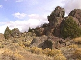
 The park features a famous configuration of boulders along the south bank of the Snake River along the trail, known alternatively as Massacre Rocks, "Gate of Death", or "Devil's Gate". Emigrants gave this name to the narrow passage of the trail through the rocks, from the fear of possible ambush by Native Americans
. According to diaries of emigrants, settlers in five wagons clashed with Shoshoni just east of the rocks on August 9–10, 1862. Ten emigrants died in the fight, which involved four wagon trains. The skirmishes took place east of the park and not at Devil's Gate as commonly believed. Some confrontations may have occurred there, but they remain unverified. The Clark Massacre
of 1851 occurred just west of Massacre Rocks, closer to the Raft River.
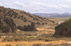
The rocks were often used as campsite for wagon trains along the trail. Many emigrants carved their names and dates on the rock face, which is now protected by a shelter. The actual passage through the rocks is now the route of Interstate 86
along the south edge of the park.
Geologically
the park was created during the repeated volcanic
activity on the Snake River Plain
. The rocks themselves were deposited in their present location at the end of the last ice age
, approximately 14,500 years ago, during the catastrophic flood known as the Bonneville Flood
, when much of Lake Bonneville
surged down the Snake River. A notch in the cliff on the north bank of the Snake opposite the park was the site of an ancient waterfall of a side channel of the waters in the aftermath of the flood.
 The park also includes a visitor center
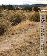
describing the history and geology of the park. It has access to the Snake River, as well as a campground. It is accessible by automobile on Interstate 86. It is also accessible on a foot trail from nearby rest areas just east of the park on Interstate 86. The footpaths also provide access to remnants of the original Oregon Trail on the south side of the highway.
Massacre Rocks became a state park in 1967, having previously been a roadside park
managed by the Idaho Department of Transportation.
State park
State parks are parks or other protected areas managed at the federated state level within those nations which use "state" as a political subdivision. State parks are typically established by a state to preserve a location on account of its natural beauty, historic interest, or recreational...
of Idaho
Idaho
Idaho is a state in the Rocky Mountain area of the United States. The state's largest city and capital is Boise. Residents are called "Idahoans". Idaho was admitted to the Union on July 3, 1890, as the 43rd state....
, USA, featuring the Massacre Rocks, a famous spot along the Oregon Trail
Oregon Trail
The Oregon Trail is a historic east-west wagon route that connected the Missouri River to valleys in Oregon and locations in between.After 1840 steam-powered riverboats and steamboats traversing up and down the Ohio, Mississippi and Missouri rivers sped settlement and development in the flat...
and California Trail
California Trail
The California Trail was an emigrant trail of about across the western half of the North American continent from Missouri River towns to what is now the state of California...
during the middle 19th century. The park is located in Power County
Power County, Idaho
Power County is a county located in the U.S. state of Idaho. As of the 2000 Census the county had a population of 7,538 ....
, along the Snake River
Snake River
The Snake is a major river of the greater Pacific Northwest in the United States. At long, it is the largest tributary of the Columbia River, the largest North American river that empties into the Pacific Ocean...
west of American Falls
American Falls, Idaho
American Falls is a city in and the county seat of Power County, Idaho, United States. The population was 4,111 at the 2000 census. It is part of the Pocatello, Idaho Metropolitan Statistical Area.-History:...
.
Description
Native Americans in the United States
Native Americans in the United States are the indigenous peoples in North America within the boundaries of the present-day continental United States, parts of Alaska, and the island state of Hawaii. They are composed of numerous, distinct tribes, states, and ethnic groups, many of which survive as...
. According to diaries of emigrants, settlers in five wagons clashed with Shoshoni just east of the rocks on August 9–10, 1862. Ten emigrants died in the fight, which involved four wagon trains. The skirmishes took place east of the park and not at Devil's Gate as commonly believed. Some confrontations may have occurred there, but they remain unverified. The Clark Massacre
Clark Massacre
In August, 1851, a band of Shoshoni led by Cho-Cho-Co, also known as Has No Horse, attacked a wagon train led by Thomas Clark on the Oregon Trail near where the Raft River joins the Snake River in present day Idaho. The Indian’s primary objective, which was accomplished, was to steal horses...
of 1851 occurred just west of Massacre Rocks, closer to the Raft River.
The rocks were often used as campsite for wagon trains along the trail. Many emigrants carved their names and dates on the rock face, which is now protected by a shelter. The actual passage through the rocks is now the route of Interstate 86
Interstate 86 (west)
Interstate 86 is an intrastate Interstate Highway, located entirely within the state of Idaho. It runs 63 miles from an intersection with Interstate 84 located approximately 7 miles east of Declo in rural Cassia County, to an intersection with Interstate 15 at Pocatello...
along the south edge of the park.
Geologically
Geology
Geology is the science comprising the study of solid Earth, the rocks of which it is composed, and the processes by which it evolves. Geology gives insight into the history of the Earth, as it provides the primary evidence for plate tectonics, the evolutionary history of life, and past climates...
the park was created during the repeated volcanic
Volcano
2. Bedrock3. Conduit 4. Base5. Sill6. Dike7. Layers of ash emitted by the volcano8. Flank| 9. Layers of lava emitted by the volcano10. Throat11. Parasitic cone12. Lava flow13. Vent14. Crater15...
activity on the Snake River Plain
Snake River Plain
The Snake River Plain is a geologic feature located primarily within the state of Idaho in the United States of America. It stretches about westward from northwest of the state of Wyoming to the Idaho-Oregon border. The plain is a wide flat bow-shaped depression, and covers about a quarter of Idaho...
. The rocks themselves were deposited in their present location at the end of the last ice age
Ice age
An ice age or, more precisely, glacial age, is a generic geological period of long-term reduction in the temperature of the Earth's surface and atmosphere, resulting in the presence or expansion of continental ice sheets, polar ice sheets and alpine glaciers...
, approximately 14,500 years ago, during the catastrophic flood known as the Bonneville Flood
Bonneville Flood
The Bonneville Flood or Lake Bonneville Flood was a catastrophic flooding event in the previous ice age, which involved massive amounts of water inundating parts of southern Idaho and eastern Washington along the course of the Snake River. Unlike the Missoula Floods, which also occurred during the...
, when much of Lake Bonneville
Lake Bonneville
Lake Bonneville was a prehistoric pluvial lake that covered much of North America's Great Basin region. Most of the territory it covered was in present-day Utah, though parts of the lake extended into present-day Idaho and Nevada. Formed about 32,000 years ago, it existed until about 14,500 years...
surged down the Snake River. A notch in the cliff on the north bank of the Snake opposite the park was the site of an ancient waterfall of a side channel of the waters in the aftermath of the flood.
Visitor center
A visitor center or centre , visitor information center, tourist information center, is a physical location that provides tourist information to the visitors who tour the place or area locally...
describing the history and geology of the park. It has access to the Snake River, as well as a campground. It is accessible by automobile on Interstate 86. It is also accessible on a foot trail from nearby rest areas just east of the park on Interstate 86. The footpaths also provide access to remnants of the original Oregon Trail on the south side of the highway.
Massacre Rocks became a state park in 1967, having previously been a roadside park
Roadside park
A roadside park is a designated park on the wide side of a road for the traveling tourist usually maintained by a governmental entity, either local, state, or national. It is for recreational use such as a picnic spot or a trail head...
managed by the Idaho Department of Transportation.