
Maryland Route 611
Encyclopedia
Maryland Route 611 is a state highway
in the U.S. state
of Maryland
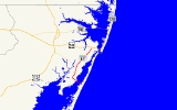
. Known as Stephen Decatur Highway, the state highway runs 8.51 miles (13.7 km) from Assateague Island
north to U.S. Route 50
(US 50) in West Ocean City
. MD 611 is named for Stephen Decatur
, the U.S. naval
officer of the early 19th century who was born in nearby Berlin
. The state highway provides access to Assateague State Park
and Assateague Island National Seashore
via the Verrazano Bridge
named for Giovanni da Verrazzano. MD 611 was first paved in West Ocean City in the mid 1930s. The highway was extended south to MD 376
at Lewis Corner in the 1940s. A ferry crossed Sinepuxent Bay
to Assateague Island from the southern end of the county highway that continued south from Lewis Corner until MD 611 was extended across the Verrazano Bridge in the mid 1960s.
and Henry's Grove
before passing through the hamlet of Lewis Corner. In Lewis Corner, the state highway intersects MD 376 (Assateague Road), passes through Frontier Town Amusement Park, and passes the entrance to another historic home, Fassitt House
. MD 611 continues northeast, with residential and commercial development increasing as the highway passes Ocean City Municipal Airport and enters West Ocean City. After passing MD 707
(Old Bridge Road), the state highway expands to four lanes shortly before reaching its northern terminus at US 50 (Ocean Gateway).
.
{| class=wikitable
!Location
!Mile
!Destinations
!Notes
|-
|rowspan=2|Assateague Island
|0.00
|Access to parking for Assateague State Park
|Southern terminus
|-
|0.09
|Bayberry Drive south – Assateague Island National Seashore
|Old alignment of MD 611
|-
|colspan=4 align=center|Verrazano Bridge
over Sinepuxent Bay
|-
|
|2.04
|South Point Road south
|
|-
|Lewis Corner
|4.49
|
|
|-
|rowspan=2|West Ocean City
|8.16
| / Old Bridge Road east
|
|-
|8.51
|
|Northern terminus
State highway
State highway, state road or state route can refer to one of three related concepts, two of them related to a state or provincial government in a country that is divided into states or provinces :#A...
in the U.S. state
U.S. state
A U.S. state is any one of the 50 federated states of the United States of America that share sovereignty with the federal government. Because of this shared sovereignty, an American is a citizen both of the federal entity and of his or her state of domicile. Four states use the official title of...
of Maryland
Maryland
Maryland is a U.S. state located in the Mid Atlantic region of the United States, bordering Virginia, West Virginia, and the District of Columbia to its south and west; Pennsylvania to its north; and Delaware to its east...
. Known as Stephen Decatur Highway, the state highway runs 8.51 miles (13.7 km) from Assateague Island
Assateague Island
Assateague Island is a long barrier island located off the eastern coast of Maryland and Virginia. It is best known for its herds of feral horses, pristine beaches, and the Assateague Lighthouse. The island also contains numerous marshes, bays and coves, including Toms Cove...
north to U.S. Route 50
U.S. Route 50 in Maryland
U.S. Route 50 is a major east–west route of the U.S. Highway system, stretching just over from Ocean City, Maryland on the Atlantic Ocean to West Sacramento, California. In the U.S. state of Maryland, US 50 exists in two sections. The longer of these serves as a major route connecting...
(US 50) in West Ocean City
West Ocean City, Maryland
West Ocean City is a census-designated place in Worcester County, Maryland, United States. The population was 3,311 at the 2000 census.-Geography:West Ocean City is located at ....
. MD 611 is named for Stephen Decatur
Stephen Decatur
Stephen Decatur, Jr. , was an American naval officer notable for his many naval victories in the early 19th century. He was born on the eastern shore of Maryland, Worcester county, the son of a U.S. Naval Officer who served during the American Revolution. Shortly after attending college Decatur...
, the U.S. naval
United States Navy
The United States Navy is the naval warfare service branch of the United States Armed Forces and one of the seven uniformed services of the United States. The U.S. Navy is the largest in the world; its battle fleet tonnage is greater than that of the next 13 largest navies combined. The U.S...
officer of the early 19th century who was born in nearby Berlin
Berlin, Maryland
Berlin is a town in Worcester County, Maryland, United States. The population was 3,491 at the 2000 census.-History:The town of Berlin had its start around the 1790s, part of the Burley Plantation, a land grant dating back to 1677...
. The state highway provides access to Assateague State Park
Assateague State Park
Assateague State Park is a public beach and state park of Maryland that lies at the northern end of Assateague Island. Reachable via Route 611, across Sinepuxent Bay via the Verrazano Bridge , Assateague State Park offers beaches and campsites to the public for a fee...
and Assateague Island National Seashore
Assateague Island National Seashore
Assateague Island National Seashore is a unit of the National Park Service occupying much of Assateague Island along the Atlantic coast of Maryland and Virginia. It is a barrier island shaped by stormy seas and gentle winds. It lies adjacent to Assateague State Park and Chincoteague National...
via the Verrazano Bridge
Verrazano Bridge (Maryland)
The Verrazano Bridge in Maryland is a bridge on Maryland Route 611 over Sinepuxent Bay that connects Assateague Island to the mainland. Like the larger and more famous Verrazano-Narrows Bridge, it is named for Giovanni da Verrazzano. The crossing contains two spans, one carrying automobiles and the...
named for Giovanni da Verrazzano. MD 611 was first paved in West Ocean City in the mid 1930s. The highway was extended south to MD 376
Maryland Route 376
Maryland Route 376 is a state highway in the U.S. state of Maryland. Known for most of its length as Assateague Road, the state highway runs from MD 818 in Berlin east to MD 611 in Lewis Corner. MD 376 connects Berlin with communities on the Sinepuxent Neck and, in conjunction with MD 611,...
at Lewis Corner in the 1940s. A ferry crossed Sinepuxent Bay
Sinepuxent Bay
Sinepuxent Bay is an inland waterway which connects Chincoteague Bay to the Ocean City Inlet. It separates Sinepuxent Neck, in Worcester County, Maryland, from Assateague Island, and is crossed by the Verrazano Bridge on Maryland State Highway 611 Sinepuxent Bay is an inland waterway which connects...
to Assateague Island from the southern end of the county highway that continued south from Lewis Corner until MD 611 was extended across the Verrazano Bridge in the mid 1960s.
Route description
MD 611 begins at the parking lot of Assateague State Park on Assateague Island. The state highway immediately intersects Bayberry Road, an old alignment of MD 611 that is the access road to Assateague Island National Seashore. MD 611 heads northwest as a two-lane road and crosses Sinepuxent Bay on the Verrazano Bridge flanked to the south by a pedestrian bridge. Upon reaching Sinepuxent Neck, the state highway curves to the northeast and intersects South Point Road, which leads to Rum Pointe Golf Course and the Ocean City Golf and Yacht Club. MD 611 passes the entrance to the historic homes Williams GroveWilliams Grove
Williams Grove is a historic home located at Berlin, Worcester County, Maryland, United States. It is a two-story, three-part house built in three principal stages. The construction sequence began about 1810 with a two-story, two-bay frame house with a single-story wing, that forms the center of...
and Henry's Grove
Henry's Grove
Henry's Grove is a historic home located at Berlin, Worcester County, Maryland, United States. It was built in 1792, and is a -story gable-roofed brick house with all walls laid in Flemish bond. The house retains virtually all of its original interior detailing. Also on the property are a...
before passing through the hamlet of Lewis Corner. In Lewis Corner, the state highway intersects MD 376 (Assateague Road), passes through Frontier Town Amusement Park, and passes the entrance to another historic home, Fassitt House
Fassitt House
Fassitt House is a historic home located at Berlin, Worcester County, Maryland, United States. It is a -story Flemish bond brick house erected about 1730 on property bordering Sinepuxent Bay. The main side features a carefully laid decorative checkerboard brick pattern. The interior features fine...
. MD 611 continues northeast, with residential and commercial development increasing as the highway passes Ocean City Municipal Airport and enters West Ocean City. After passing MD 707
Maryland Route 707
Maryland Route 707 is a collection of state highways in the Maryland Route 707 is a collection of [[state highway|state highways]] in the...
(Old Bridge Road), the state highway expands to four lanes shortly before reaching its northern terminus at US 50 (Ocean Gateway).
History
MD 611 was paved from US 213 (now MD 707) to near the Sinepuxent Road intersection on the southern end of West Ocean City by 1935. By 1946, the state highway extended north to the US 213 divided highway and south to MD 376 in Lewis Corner. A ferry began service between the southern end of South Point Road and Assateague Island in 1957; this ferry reached the island at what is now Ferry Landing Road. The ferry was discontinued following the completion of the Verrazano Bridge in 1964. MD 611 was extended south from Lewis Corner to the eastern end of the Verrazano Bridge in 1967. The state highway was extended south to Ferry Landing Road in 1969 but was retracted to its present southern terminus by 1995.Junction list
The entire route is in Worcester CountyWorcester County, Maryland
-2010:Whereas according to the 2010 U.S. Census Bureau:*82.0% White*13.6% Black*0.3% Native American*1.1% Asian*0.0% Native Hawaiian or Pacific Islander*1.7% Two or more races*1.3% Other races*3.2% Hispanic or Latino -2000:...
.
{| class=wikitable
!Location
!Mile
!Destinations
!Notes
|-
|rowspan=2|Assateague Island
Assateague Island
Assateague Island is a long barrier island located off the eastern coast of Maryland and Virginia. It is best known for its herds of feral horses, pristine beaches, and the Assateague Lighthouse. The island also contains numerous marshes, bays and coves, including Toms Cove...
|0.00
|Access to parking for Assateague State Park
Assateague State Park
Assateague State Park is a public beach and state park of Maryland that lies at the northern end of Assateague Island. Reachable via Route 611, across Sinepuxent Bay via the Verrazano Bridge , Assateague State Park offers beaches and campsites to the public for a fee...
|Southern terminus
|-
|0.09
|Bayberry Drive south – Assateague Island National Seashore
Assateague Island National Seashore
Assateague Island National Seashore is a unit of the National Park Service occupying much of Assateague Island along the Atlantic coast of Maryland and Virginia. It is a barrier island shaped by stormy seas and gentle winds. It lies adjacent to Assateague State Park and Chincoteague National...
|Old alignment of MD 611
|-
|colspan=4 align=center|Verrazano Bridge
Verrazano Bridge (Maryland)
The Verrazano Bridge in Maryland is a bridge on Maryland Route 611 over Sinepuxent Bay that connects Assateague Island to the mainland. Like the larger and more famous Verrazano-Narrows Bridge, it is named for Giovanni da Verrazzano. The crossing contains two spans, one carrying automobiles and the...
over Sinepuxent Bay
Sinepuxent Bay
Sinepuxent Bay is an inland waterway which connects Chincoteague Bay to the Ocean City Inlet. It separates Sinepuxent Neck, in Worcester County, Maryland, from Assateague Island, and is crossed by the Verrazano Bridge on Maryland State Highway 611 Sinepuxent Bay is an inland waterway which connects...
|-
|
|2.04
|South Point Road south
|
|-
|Lewis Corner
|4.49
|
|
|-
|rowspan=2|West Ocean City
West Ocean City, Maryland
West Ocean City is a census-designated place in Worcester County, Maryland, United States. The population was 3,311 at the 2000 census.-Geography:West Ocean City is located at ....
|8.16
| / Old Bridge Road east
|
|-
|8.51
|
|Northern terminus