
Maryland Route 61
Encyclopedia
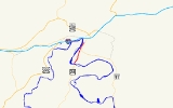
Maryland Route 61 is an unsigned
state highway
in the U.S. state
of Maryland
. Known as Canal Parkway, the state highway begins at the West Virginia
state line at the Potomac River
opposite Wiley Ford
, where the highway continues south as West Virginia Route 28 (WV 28). The state highway runs 1.94 miles (3.1 km) north as an automobile parkway
to MD 51
within the city of Cumberland
. MD 61 provides a connection between downtown Cumberland and the South Cumberland neighborhood and with Greater Cumberland Regional Airport
, which is located in Mineral County, West Virginia
.
Canal Parkway was constructed as part of a broad group of projects to revitalize the Potomac River waterfront of Cumberland, centered around the historical Chesapeake and Ohio Canal
(C&O Canal). The parkway was constructed both as a scenic highway and to improve access to South Cumberland and the airport, which were often cut off from the rest of Cumberland by flooding or traffic jams at the sole connecting point, a railroad underpass on Virginia Avenue. New bridges over the Potomac River and the C&O Canal were built in 1992 and 1997, while the portion of Canal Parkway from the canal crossing toward downtown Cumberland was constructed between 1999 and 2001.
As the parkway is approached by CSX
's Cumberland Terminal Subdivision
west of the Cumberland rail yard
, the parkway ceases to be shielded by trees. MD 61 rises onto a retaining wall above the level of the C&O Canal to the west and on level with the railroad that begins to closely parallel the state highway to the east. The state highway's elevation allows views of the Potomac River and Knobly Mountain
to the west but discourage views of the adjacent C&O Canal and MD 51 (Industrial Parkway), which parallels the east side of the railroad. MD 61 descends from the retaining wall to cross a rail spur from the Cumberland Terminal Subdivision that heads north to Canal Place. The two directions of the state highway split for a partial interchange with MD 51, with the northbound lane passing under MD 51's overpass of the railroad. The northbound lane of MD 61 has a right-in/right-out
interchange with Wineow Street before merging with westbound MD 51 a short distance south of downtown Cumberland.
in the Potomac River just east of the present bridge over the river. The first bridge at Wiley Ford was constructed around 1908; a replacement bridge was built in the late 1950s. Traffic heading to Wiley Ford from downtown Cumberland travelled Virginia Avenue south from Oldtown Road, the old alignment of MD 51, then followed River Avenue southwest to its present intersection with Canal Parkway, then south across the river along Ford Avenue, which followed the same alignment as MD 61 today. In addition to the route suffering from the standard problems of travelling through city streets, Virginia Avenue passed under the Baltimore & Ohio Railroad tracks via a low, narrow underpass that was vulnerable to flooding and, due to its location immediately south of Virginia Avenue's intersections with MD 51, was the frequent site of traffic jams. A problem at the underpass isolated South Cumberland south of the tracks from the rest of the city and required a lengthy detour through West Virginia. The same problems also hindered access to Greater Cumberland Regional Airport from the city.
Canal Parkway was constructed as part of a broad group of projects to revitalize the Potomac River waterfront south of downtown Cumberland starting in 1989. These projects included:
The first section of Canal Parkway to be built was the reconstruction of Ford Avenue from the West Virginia state line to River Avenue. A new bridge over the Potomac River was completed in 1992. A new bridge over the C&O Canal was completed in 1997, eliminating an at-grade crossing of the highway and the C&O Canal towpath. Construction of Canal Parkway from River Avenue to MD 51 was underway by 1999 and completed in 2001, at which time the highway received the unsigned MD 61 designation.
MD 61 originally had two auxiliary routes:
Both auxiliary routes were transferred to municipal maintenance in 2005.
in Allegany County
.
{|class=wikitable
!Mile
!Destinations
!Notes
|-
|0.00
| – Wiley Ford
, Greater Cumberland Regional Airport
|Southern terminus; West Virginia
state line at Potomac River
|-
|0.35
|River Avenue
|Former MD 61B
|-
|1.94
|
|Northern terminus; eastbound exit from and westbound entrance to MD 51
Unsigned highway
An unsigned highway is a highway that has been assigned a route number, but does not bear conventional road markings that would normally be used to identify the route with that number...
state highway
State highway
State highway, state road or state route can refer to one of three related concepts, two of them related to a state or provincial government in a country that is divided into states or provinces :#A...
in the U.S. state
U.S. state
A U.S. state is any one of the 50 federated states of the United States of America that share sovereignty with the federal government. Because of this shared sovereignty, an American is a citizen both of the federal entity and of his or her state of domicile. Four states use the official title of...
of Maryland
Maryland
Maryland is a U.S. state located in the Mid Atlantic region of the United States, bordering Virginia, West Virginia, and the District of Columbia to its south and west; Pennsylvania to its north; and Delaware to its east...
. Known as Canal Parkway, the state highway begins at the West Virginia
West Virginia
West Virginia is a state in the Appalachian and Southeastern regions of the United States, bordered by Virginia to the southeast, Kentucky to the southwest, Ohio to the northwest, Pennsylvania to the northeast and Maryland to the east...
state line at the Potomac River
Potomac River
The Potomac River flows into the Chesapeake Bay, located along the mid-Atlantic coast of the United States. The river is approximately long, with a drainage area of about 14,700 square miles...
opposite Wiley Ford
Wiley Ford, West Virginia
Wiley Ford is a census-designated place in Mineral County, West Virginia, United States and part of the 'Cumberland, MD-WV Metropolitan Statistical Area'...
, where the highway continues south as West Virginia Route 28 (WV 28). The state highway runs 1.94 miles (3.1 km) north as an automobile parkway
Parkway
The term parkway has several distinct principal meanings and numerous synonyms around the world, for either a type of landscaped area or a type of road.Type of landscaped area:...
to MD 51
Maryland Route 51
Maryland Route 51 is a state highway in the U.S. state of Maryland. Known for most of its length as Oldtown Road, the state highway runs from an interchange with Interstate 68 in Cumberland east to the West Virginia state line at the Potomac River, where the highway continues east as West...
within the city of Cumberland
Cumberland, Maryland
Cumberland is a city in the far western, Appalachian portion of Maryland, United States. It is the county seat of Allegany County, and the primary city of the Cumberland, MD-WV Metropolitan Statistical Area. At the 2010 census, the city had a population of 20,859, and the metropolitan area had a...
. MD 61 provides a connection between downtown Cumberland and the South Cumberland neighborhood and with Greater Cumberland Regional Airport
Greater Cumberland Regional Airport
Greater Cumberland Regional Airport is a public airport located in the town of Wiley Ford in Mineral County, West Virginia. It is two miles south of the larger city of Cumberland in Allegany County, Maryland...
, which is located in Mineral County, West Virginia
Mineral County, West Virginia
Mineral County is a county located in the U.S. state of West Virginia. It is part of the Cumberland, MD-WV Metropolitan Statistical Area. As of 2010, the population was 28,212. Its county seat is Keyser.-Ancient history:...
.
Canal Parkway was constructed as part of a broad group of projects to revitalize the Potomac River waterfront of Cumberland, centered around the historical Chesapeake and Ohio Canal
Chesapeake and Ohio Canal
The Chesapeake and Ohio Canal, abbreviated as the C&O Canal, and occasionally referred to as the "Grand Old Ditch," operated from 1831 until 1924 parallel to the Potomac River in Maryland from Cumberland, Maryland to Washington, D.C. The total length of the canal is about . The elevation change of...
(C&O Canal). The parkway was constructed both as a scenic highway and to improve access to South Cumberland and the airport, which were often cut off from the rest of Cumberland by flooding or traffic jams at the sole connecting point, a railroad underpass on Virginia Avenue. New bridges over the Potomac River and the C&O Canal were built in 1992 and 1997, while the portion of Canal Parkway from the canal crossing toward downtown Cumberland was constructed between 1999 and 2001.
Route description
MD 61 begins at the West Virginia state line on a bridge across the Potomac River between Wiley Ford and the southern edge of the city of Cumberland. The roadway continues south as WV 28 through Wiley Ford toward Greater Cumberland Regional Airport. MD 61 heads north as a two-lane highway, crossing the C&O Canal and its towpath on a Warren truss bridge. The state highway gains a median and intersects River Avenue, part of the old connection from Cumberland to Wiley Ford that serves the South Cumberland neighborhood. No trucks are allowed on MD 61 north of River Avenue. MD 61 continues north between the C&O Canal to the west and an industrial area to the east, both of which are shielded from view by trees and walls. Beyond Elder Street, the state highway reduces to a two-lane road without a median.As the parkway is approached by CSX
CSX Transportation
CSX Transportation operates a Class I railroad in the United States known as the CSX Railroad. It is the main subsidiary of the CSX Corporation. The company is headquartered in Jacksonville, Florida, and owns approximately 21,000 route miles...
's Cumberland Terminal Subdivision
Cumberland Terminal Subdivision
The Cumberland Terminal Subdivision is a railroad line owned and operated by CSX Transportation in the Cumberland, Maryland area. The line centers around the Cumberland rail yard and is a junction with three other subdivisions....
west of the Cumberland rail yard
Rail yard
A rail yard, or railroad yard, is a complex series of railroad tracks for storing, sorting, or loading/unloading, railroad cars and/or locomotives. Railroad yards have many tracks in parallel for keeping rolling stock stored off the mainline, so that they do not obstruct the flow of traffic....
, the parkway ceases to be shielded by trees. MD 61 rises onto a retaining wall above the level of the C&O Canal to the west and on level with the railroad that begins to closely parallel the state highway to the east. The state highway's elevation allows views of the Potomac River and Knobly Mountain
Knobly Mountain
Knobly Mountain is a part of the Ridge-and-Valley Appalachians, located east of New Creek Mountain in Mineral and Grant counties, West Virginia, in the United States....
to the west but discourage views of the adjacent C&O Canal and MD 51 (Industrial Parkway), which parallels the east side of the railroad. MD 61 descends from the retaining wall to cross a rail spur from the Cumberland Terminal Subdivision that heads north to Canal Place. The two directions of the state highway split for a partial interchange with MD 51, with the northbound lane passing under MD 51's overpass of the railroad. The northbound lane of MD 61 has a right-in/right-out
Right-in/right-out
Right-in/right-out and left-in/left-out refer to a type of road intersection where turning movements of vehicles are restricted. A RIRO permits only right turns and a LILO permits only left turns. RIRO is usual where vehicles drive on the right, and LILO is usual where vehicles drive on the left...
interchange with Wineow Street before merging with westbound MD 51 a short distance south of downtown Cumberland.
History
Wiley Ford is named for a shallow spotFord (crossing)
A ford is a shallow place with good footing where a river or stream may be crossed by wading or in a vehicle. A ford is mostly a natural phenomenon, in contrast to a low water crossing, which is an artificial bridge that allows crossing a river or stream when water is low.The names of many towns...
in the Potomac River just east of the present bridge over the river. The first bridge at Wiley Ford was constructed around 1908; a replacement bridge was built in the late 1950s. Traffic heading to Wiley Ford from downtown Cumberland travelled Virginia Avenue south from Oldtown Road, the old alignment of MD 51, then followed River Avenue southwest to its present intersection with Canal Parkway, then south across the river along Ford Avenue, which followed the same alignment as MD 61 today. In addition to the route suffering from the standard problems of travelling through city streets, Virginia Avenue passed under the Baltimore & Ohio Railroad tracks via a low, narrow underpass that was vulnerable to flooding and, due to its location immediately south of Virginia Avenue's intersections with MD 51, was the frequent site of traffic jams. A problem at the underpass isolated South Cumberland south of the tracks from the rest of the city and required a lengthy detour through West Virginia. The same problems also hindered access to Greater Cumberland Regional Airport from the city.
Canal Parkway was constructed as part of a broad group of projects to revitalize the Potomac River waterfront south of downtown Cumberland starting in 1989. These projects included:
- The rehabilitation of the C&O Canal, including its re-watering, through the Cumberland portion of the Chesapeake and Ohio Canal National Historical ParkChesapeake and Ohio Canal National Historical ParkThe Chesapeake and Ohio Canal National Historical Park is a United States National Historical Park located in the District of Columbia and the states of Maryland and West Virginia. The park was established as a National Monument in 1961 by President Dwight D...
by the U.S. Army Corps of Engineers. - Restoration of historic Western Maryland RailwayWestern Maryland RailwayThe Western Maryland Railway was an American Class I railroad which operated in Maryland, West Virginia, and Pennsylvania. It was primarily a coal hauling and freight railroad, with a small passenger train operation. The WM became part of the Chessie System in 1973 and ceased operating its lines...
properties, which included restoration of the former Western Maryland Railway StationWestern Maryland Railway Station (Cumberland, Maryland)Western Maryland Railway Station is a historic railway station in Cumberland, Allegany County, Maryland. It was built in 1913 as a stop for the Western Maryland Railway , and is a large commercial-style building that expresses the architectural functionalism of the turn of the 20th century...
and establishment of the Western Maryland Scenic RailroadWestern Maryland Scenic RailroadThe Western Maryland Scenic Railroad is a heritage railroad based in Cumberland, Maryland. It operates over ex-Western Maryland Railway trackage to Frostburg, Maryland and back using both steam and diesel locomotives....
, a heritage railroad. - The construction of new bridges across the Potomac River and C&O Canal and an automobile parkway along a portion of the canal by the Maryland State Highway AdministrationMaryland State Highway AdministrationThe Maryland State Highway Administration is the state agency responsible for maintaining Maryland numbered highways outside of Baltimore City...
to serve as a scenic highway and to improve access to Greater Cumberland Regional Airport. - The construction of Canal PlaceCanal PlaceCanal Place is a park owned by the State of Maryland and located in Cumberland, MD. The park includes the Western Maryland Railway Station, station plaza, a picnic area, a canal boat replica, a pedestrian bridge to George Washington’s Headquarters , picnic area, Shops at Canal Place, and the...
by the National Park ServiceNational Park ServiceThe National Park Service is the U.S. federal agency that manages all national parks, many national monuments, and other conservation and historical properties with various title designations...
to tie together these and other historical properties, including Fort CumberlandFort Cumberland (Maryland)thumb|380px|Fort Cumberland, 1755 Fort Cumberland was an 18th century frontier fort at the current site of Cumberland, Maryland, USA...
and the Downtown Cumberland Historic DistrictDowntown Cumberland Historic DistrictThe Downtown Cumberland Historic District, also referred to as the Downtown Cumberland Mall, is the main shopping and dining district for the city of Cumberland, Maryland.-Location:...
.
The first section of Canal Parkway to be built was the reconstruction of Ford Avenue from the West Virginia state line to River Avenue. A new bridge over the Potomac River was completed in 1992. A new bridge over the C&O Canal was completed in 1997, eliminating an at-grade crossing of the highway and the C&O Canal towpath. Construction of Canal Parkway from River Avenue to MD 51 was underway by 1999 and completed in 2001, at which time the highway received the unsigned MD 61 designation.
MD 61 originally had two auxiliary routes:
- MD 61A was the designation for an unnamed 0.14 mile (0.2253076 km) connector west from the intersection of MD 61 and River Avenue to serve properties between the highway and the C&O Canal.
- MD 61B was the designation for a 0.08 mile (0.1287472 km) section of River Avenue immediately east of its intersection with MD 61.
Both auxiliary routes were transferred to municipal maintenance in 2005.
Junction list
The entire route is in CumberlandCumberland, Maryland
Cumberland is a city in the far western, Appalachian portion of Maryland, United States. It is the county seat of Allegany County, and the primary city of the Cumberland, MD-WV Metropolitan Statistical Area. At the 2010 census, the city had a population of 20,859, and the metropolitan area had a...
in Allegany County
Allegany County, Maryland
Allegany County is a county located in the northwestern part of the US state of Maryland. It is part of the Cumberland, MD-WV Metropolitan Statistical Area. As of 2010, the population was 75,087. Its county seat is Cumberland...
.
{|class=wikitable
!Mile
!Destinations
!Notes
|-
|0.00
| – Wiley Ford
Wiley Ford, West Virginia
Wiley Ford is a census-designated place in Mineral County, West Virginia, United States and part of the 'Cumberland, MD-WV Metropolitan Statistical Area'...
, Greater Cumberland Regional Airport
Greater Cumberland Regional Airport
Greater Cumberland Regional Airport is a public airport located in the town of Wiley Ford in Mineral County, West Virginia. It is two miles south of the larger city of Cumberland in Allegany County, Maryland...
|Southern terminus; West Virginia
West Virginia
West Virginia is a state in the Appalachian and Southeastern regions of the United States, bordered by Virginia to the southeast, Kentucky to the southwest, Ohio to the northwest, Pennsylvania to the northeast and Maryland to the east...
state line at Potomac River
Potomac River
The Potomac River flows into the Chesapeake Bay, located along the mid-Atlantic coast of the United States. The river is approximately long, with a drainage area of about 14,700 square miles...
|-
|0.35
|River Avenue
|Former MD 61B
|-
|1.94
|
|Northern terminus; eastbound exit from and westbound entrance to MD 51