
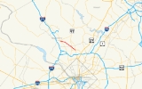
Maryland Route 586
Encyclopedia
Maryland Route 586 is a state highway
in the U.S. state
of Maryland
. Known as Veirs Mill Road, the state highway runs 5.78 mi (9.3 km) from MD 28
in Rockville
east to MD 97
in Wheaton
.
. After intersecting Aspen Hill Road, MD 586 passes between Rock Creek Regional Park on the south and the southwestern edge of the residential subdivisions of Aspen Hill
on the north. Residential subdivisions surround the highway on both sides again shortly before the highway crosses Turkey Branch. MD 586 expands to six lanes shortly before its intersection with Randolph Road
.
MD 586 continues southeast between densely-populated residential subdivisions in Wheaton. The state highway intersects MD 185
(Connecticut Avenue) at an acute angle and reduces to four full-use lanes at Newport Mill Road, with a combination right-turn and bus lane in the eastbound direction. The westbound direction gains a third lane shortly before MD 586 enters downtown Wheaton and intersects MD 193
. The state highway continues southeast with five lanes as it passes between the Wheaton Plaza
shopping mall on the west and the Wheaton Metro Station
on the east. MD 586 reaches its southern terminus at a directional intersection with MD 97 (Georgia Avenue). There is no access between MD 586 east and MD 97 north.
and sawmill
on Rock Creek built by Samuel Clark Veirs in 1838 and operated by his family until 1924.
.
State highway
State highway, state road or state route can refer to one of three related concepts, two of them related to a state or provincial government in a country that is divided into states or provinces :#A...
in the U.S. state
U.S. state
A U.S. state is any one of the 50 federated states of the United States of America that share sovereignty with the federal government. Because of this shared sovereignty, an American is a citizen both of the federal entity and of his or her state of domicile. Four states use the official title of...
of Maryland
Maryland
Maryland is a U.S. state located in the Mid Atlantic region of the United States, bordering Virginia, West Virginia, and the District of Columbia to its south and west; Pennsylvania to its north; and Delaware to its east...
. Known as Veirs Mill Road, the state highway runs 5.78 mi (9.3 km) from MD 28
Maryland Route 28
Maryland Route 28 is a state highway in the U.S. state of Maryland. The state highway runs from U.S. Route 15 in Point of Rocks east to MD 182 in Norwood. The western portion of MD 28 is a rural highway connecting several villages in southern Frederick County and western Montgomery County...
in Rockville
Rockville, Maryland
Rockville is the county seat of Montgomery County, Maryland, United States. It is a major incorporated city in the central part of Montgomery County and forms part of the Baltimore-Washington Metropolitan Area. The 2010 U.S...
east to MD 97
Maryland Route 97
Maryland Route 97 is a state highway in the U.S. state of Maryland. The route runs from U.S. Route 29 in Silver Spring, Montgomery County north to the Pennsylvania border in Carroll County, where the road continues into that state as Pennsylvania Route 97...
in Wheaton
Wheaton, Maryland
Wheaton is an unincorporated, urbanized area in Montgomery County, Maryland, USA, north of Washington, D.C., northwest of Silver Spring. Wheaton takes its name from Frank Wheaton , a career officer in the United States Army and volunteer from Rhode Island in the Union Army who rose to the rank of...
.
Route description
MD 586 begins at an intersection with MD 28 and MD 911 in Rockville. Veirs Mill Road continues west as MD 28 west, which heads toward downtown Rockville and provides access to northbound MD 355. First Street heads north as eastbound MD 28 and south as MD 911, which provides a connection to southbound MD 355. MD 586 heads southeast as a four-lane divided highway flanked by service roads on both sides that serve the dense residential subdivisions between which the highway passes. The service roads end at the eastern limits of Rockville, where the state highway intersects Twinbrook Parkway and crosses Rock CreekRock Creek (Potomac River)
Rock Creek is a free-flowing tributary of the Potomac River, which empties into the Atlantic Ocean via the Chesapeake Bay. The creek is long, with a drainage area of about...
. After intersecting Aspen Hill Road, MD 586 passes between Rock Creek Regional Park on the south and the southwestern edge of the residential subdivisions of Aspen Hill
Aspen Hill, Maryland
Aspen Hill is a census-designated place and an unincorporated area in Montgomery County, Maryland. It got its name from aspen trees that once were found near the first post office in the area...
on the north. Residential subdivisions surround the highway on both sides again shortly before the highway crosses Turkey Branch. MD 586 expands to six lanes shortly before its intersection with Randolph Road
Randolph Road
Randolph Road is a major cross-county road in Montgomery County, Maryland, and is part of a longer road that runs across Montgomery and Prince George's counties. The full road, which is also known as Montrose Road on the western end and Cherry Hill Road at the southeast, runs between the Potomac...
.
MD 586 continues southeast between densely-populated residential subdivisions in Wheaton. The state highway intersects MD 185
Maryland Route 185
Maryland Route 185 is a state highway in the U.S. state of Maryland. Known as Connecticut Avenue, the state highway runs from Chevy Chase Circle at the Washington, D.C. border north to MD 97 in Aspen Hill...
(Connecticut Avenue) at an acute angle and reduces to four full-use lanes at Newport Mill Road, with a combination right-turn and bus lane in the eastbound direction. The westbound direction gains a third lane shortly before MD 586 enters downtown Wheaton and intersects MD 193
Maryland Route 193
Maryland Route 193 is a state highway in the U.S. state of Maryland. Known for most of its length as University Boulevard and Greenbelt Road, the state highway runs from MD 185 in Kensington east to MD 202 in Greater Upper Marlboro...
. The state highway continues southeast with five lanes as it passes between the Wheaton Plaza
Westfield Wheaton
Westfield Wheaton is a two-level enclosed shopping mall in Wheaton, Maryland. It is owned by The Westfield Group.-History:...
shopping mall on the west and the Wheaton Metro Station
Wheaton (Washington Metro)
Wheaton is a Washington Metro station in Montgomery County, Maryland on the Red Line.The station serves the suburb of Wheaton, and is located at the intersection of Georgia Avenue and Reedie Drive. This station features the longest set of single-span escalators in the Western Hemisphere, each...
on the east. MD 586 reaches its southern terminus at a directional intersection with MD 97 (Georgia Avenue). There is no access between MD 586 east and MD 97 north.
History
MD 586 is named after a water-powered gristGristmill
The terms gristmill or grist mill can refer either to a building in which grain is ground into flour, or to the grinding mechanism itself.- Early history :...
and sawmill
Sawmill
A sawmill is a facility where logs are cut into boards.-Sawmill process:A sawmill's basic operation is much like those of hundreds of years ago; a log enters on one end and dimensional lumber exits on the other end....
on Rock Creek built by Samuel Clark Veirs in 1838 and operated by his family until 1924.
Junction list
The entire route is in Montgomery CountyMontgomery County, Maryland
Montgomery County is a county in the U.S. state of Maryland, situated just to the north of Washington, D.C., and southwest of the city of Baltimore. It is one of the most affluent counties in the United States, and has the highest percentage of residents over 25 years of age who hold post-graduate...
.
| Location | Mile |
Destinations | Notes |
|---|---|---|---|
| Rockville Rockville, Maryland Rockville is the county seat of Montgomery County, Maryland, United States. It is a major incorporated city in the central part of Montgomery County and forms part of the Baltimore-Washington Metropolitan Area. The 2010 U.S... |
0.00 | Western terminus | |
| Wheaton Wheaton, Maryland Wheaton is an unincorporated, urbanized area in Montgomery County, Maryland, USA, north of Washington, D.C., northwest of Silver Spring. Wheaton takes its name from Frank Wheaton , a career officer in the United States Army and volunteer from Rhode Island in the Union Army who rose to the rank of... |
3.48 | Randolph Road Randolph Road Randolph Road is a major cross-county road in Montgomery County, Maryland, and is part of a longer road that runs across Montgomery and Prince George's counties. The full road, which is also known as Montrose Road on the western end and Cherry Hill Road at the southeast, runs between the Potomac... – North Bethesda North Bethesda, Maryland North Bethesda is a census-designated place and an unincorporated area in Montgomery County, Maryland, United States. It borders the city of Rockville, and is closely associated with the city.-Geography:... , Glenmont Glenmont, Maryland Glenmont is an unincorporated community in Montgomery County, Maryland, USA. The U.S. Census Bureau combines Glenmont with nearby Wheaton to create the Census Designated Place of Wheaton-Glenmont.- Location :... |
|
| 4.01 | |||
| 5.36 | |||
| 5.78 | Eastern terminus; no access from eastbound MD 586 to northbound MD 97 |