
Maryland Route 366
Encyclopedia
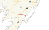
Maryland Route 366 is a state highway
in the U.S. state
of Maryland
. Known for much of its length as Stockton Road, the state highway runs 11.17 miles (18 km) from U.S. Route 13 Business in Pocomoke City
east to the entrance of George Island Landing
on Chincoteague Bay
. MD 366 is the main east–west highway of southern Worcester County
, connecting US 13
in Pocomoke City with MD 12
in Stockton
. The state highway was constructed starting in the mid 1910s from the Pocomoke City end. MD 366 was completed between Pocomoke City and Stockton in the early 1920s. The state highway was extended east to George Island Landing in the mid 1930s.
, where the highway intersects Lambertson Road and Holly Swamp Road. After leaving Goodwill, the state highway meets unsigned MD 703 (Klej Grange Road). MD 366 continues east through farmland, intersecting Old Mill Road before entering the unincorporated village of Stockton. Within the village, the state highway intersects MD 12 (Snow Hill Road), where the name of MD 366 changes to George Island Landing Road. After passing Greenbackville Road, the state highway goes through a straight then performs an S-curve over the marshland of E.A. Vaughn Wildlife Management Area before meeting its eastern terminus at the entrance to the parking lot of George Island Landing on Chincoteague Bay.
.
{| class=wikitable
!Location
!Mile
!Destinations
!Notes
|-
|rowspan=2|Pocomoke City
|0.00
|
|Western terminus
|-
|0.20
|, Norfolk
|
|-
|Goodwill
|4.09
|
|
|-
|rowspan=2|Stockton
|8.39
|, Sinnickson, VA
|
|-
|9.46
|Greenbackville Road south – Greenbackville, VA
|Former MD 502
|-
|George Island Landing
|11.17
|Entrance of George Island Landing
|Eastern terminus
State highway
State highway, state road or state route can refer to one of three related concepts, two of them related to a state or provincial government in a country that is divided into states or provinces :#A...
in the U.S. state
U.S. state
A U.S. state is any one of the 50 federated states of the United States of America that share sovereignty with the federal government. Because of this shared sovereignty, an American is a citizen both of the federal entity and of his or her state of domicile. Four states use the official title of...
of Maryland
Maryland
Maryland is a U.S. state located in the Mid Atlantic region of the United States, bordering Virginia, West Virginia, and the District of Columbia to its south and west; Pennsylvania to its north; and Delaware to its east...
. Known for much of its length as Stockton Road, the state highway runs 11.17 miles (18 km) from U.S. Route 13 Business in Pocomoke City
Pocomoke City, Maryland
Pocomoke City, dubbed "the friendliest town on the Eastern Shore", is a city in Worcester County, Maryland, United States. Although renamed in a burst of civic enthusiasm in 1878, the city is regularly referred to by its inhabitants simply as Pocomoke...
east to the entrance of George Island Landing
George Island Landing, Maryland
George Island Landing is an unincorporated community in Worcester County, Maryland, United States. George Island Landing is located at the eastern end of Maryland Route 366 on Chincoteague Bay.-References:...
on Chincoteague Bay
Chincoteague Bay
Chincoteague Bay is a lagoon between the Atlantic barrier islands of Assateague and Chincoteague and the mainland of Worcester County, Maryland and northern Accomack County, Virginia...
. MD 366 is the main east–west highway of southern Worcester County
Worcester County, Maryland
-2010:Whereas according to the 2010 U.S. Census Bureau:*82.0% White*13.6% Black*0.3% Native American*1.1% Asian*0.0% Native Hawaiian or Pacific Islander*1.7% Two or more races*1.3% Other races*3.2% Hispanic or Latino -2000:...
, connecting US 13
U.S. Route 13 in Maryland
U.S. Route 13 is a U.S. Highway running from Fayetteville, North Carolina north to Morrisville, Pennsylvania. In the U.S. state of Maryland, the route runs from the Virginia border south of Pocomoke City in Worcester County north to the Delaware border in Delmar, Wicomico County, where the route...
in Pocomoke City with MD 12
Maryland Route 12
Maryland Route 12 is a state highway on the Eastern Shore in the U.S. state of Maryland. The route runs from the Virginia border south of Stockton, Worcester County, where it continues into Virginia as State Route 679, north to Main Street in the city of Salisbury in Wicomico County...
in Stockton
Stockton, Maryland
Stockton is a census-designated place in Worcester County, Maryland, United States. The population was 143 at the 2000 census.-History:...
. The state highway was constructed starting in the mid 1910s from the Pocomoke City end. MD 366 was completed between Pocomoke City and Stockton in the early 1920s. The state highway was extended east to George Island Landing in the mid 1930s.
Route description
MD 366 begins at an intersection with US 13 Business (Market Street) on the southern edge of Pocomoke City. The state highway, marked as Stockton Road, turns south and then east to the intersection with US 13 (Ocean Highway). After crossing the federal highway, MD 366 heads east as a two-lane road, crosses Town Branch and passes Newtown Park. The state highway leaves the town of Pocomoke City after the intersection with Groton Road and Buck Harbor Road. After passing Byrd Road and crossing Pilchard Creek, MD 366 enters the hamlet of GoodwillGoodwill, Maryland
Goodwill is a small unincorporated community 5 miles east of Pocomoke City in Worcester County, Maryland, located at . Originally called Davis Crossroads, or simply Crossroads, Goodwill grew at the crossing of the roads leading from Mattapony Landing on the Pocomoke River down into Virginia, and...
, where the highway intersects Lambertson Road and Holly Swamp Road. After leaving Goodwill, the state highway meets unsigned MD 703 (Klej Grange Road). MD 366 continues east through farmland, intersecting Old Mill Road before entering the unincorporated village of Stockton. Within the village, the state highway intersects MD 12 (Snow Hill Road), where the name of MD 366 changes to George Island Landing Road. After passing Greenbackville Road, the state highway goes through a straight then performs an S-curve over the marshland of E.A. Vaughn Wildlife Management Area before meeting its eastern terminus at the entrance to the parking lot of George Island Landing on Chincoteague Bay.
History
The Pocomoke City–Stockton road was paved within Stockton and from Market Street east to Groton Road in Pocomoke City by 1910. Two sections of the state highway were paved from the Pocomoke City end in 1915 and 1917. By 1921, 2 miles (3.2 km) sections were built from Stockton west to Old Mill Road and east to Goodwill from the Pocomoke City End. The highway between Pocomoke City and Stockton was completed in 1923. MD 366 was under construction from the eastern end of pavement in Stockton to George Island Landing by 1934 and completed in 1935.Junction list
The entire route is in Worcester CountyWorcester County, Maryland
-2010:Whereas according to the 2010 U.S. Census Bureau:*82.0% White*13.6% Black*0.3% Native American*1.1% Asian*0.0% Native Hawaiian or Pacific Islander*1.7% Two or more races*1.3% Other races*3.2% Hispanic or Latino -2000:...
.
{| class=wikitable
!Location
!Mile
!Destinations
!Notes
|-
|rowspan=2|Pocomoke City
Pocomoke City, Maryland
Pocomoke City, dubbed "the friendliest town on the Eastern Shore", is a city in Worcester County, Maryland, United States. Although renamed in a burst of civic enthusiasm in 1878, the city is regularly referred to by its inhabitants simply as Pocomoke...
|0.00
|
|Western terminus
|-
|0.20
|, Norfolk
Norfolk, Virginia
Norfolk is an independent city in the Commonwealth of Virginia in the United States. With a population of 242,803 as of the 2010 Census, it is Virginia's second-largest city behind neighboring Virginia Beach....
|
|-
|Goodwill
Goodwill, Maryland
Goodwill is a small unincorporated community 5 miles east of Pocomoke City in Worcester County, Maryland, located at . Originally called Davis Crossroads, or simply Crossroads, Goodwill grew at the crossing of the roads leading from Mattapony Landing on the Pocomoke River down into Virginia, and...
|4.09
|
|
|-
|rowspan=2|Stockton
Stockton, Maryland
Stockton is a census-designated place in Worcester County, Maryland, United States. The population was 143 at the 2000 census.-History:...
|8.39
|, Sinnickson, VA
Sinnickson, Virginia
-References:*...
|
|-
|9.46
|Greenbackville Road south – Greenbackville, VA
Greenbackville, Virginia
Greenbackville is a census-designated place 4.5 miles south of Stockton, Maryland in Accomack County, Virginia, located just south of the Maryland state line at . The population as of the 2010 Census was 192...
|Former MD 502
|-
|George Island Landing
George Island Landing, Maryland
George Island Landing is an unincorporated community in Worcester County, Maryland, United States. George Island Landing is located at the eastern end of Maryland Route 366 on Chincoteague Bay.-References:...
|11.17
|Entrance of George Island Landing
|Eastern terminus