
Maryland Route 12
Encyclopedia
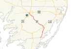
Maryland Route 12 is a state highway on the Eastern Shore in the U.S. state
of Maryland
. The route runs 30.63 mi (49.29 km) from the Virginia
border south of Stockton
, Worcester County
, where it continues into Virginia as State Route 679, north to Main Street in the city of Salisbury
in Wicomico County
. The route is known as Snow Hill Road for most of its length and passes mostly through areas of woods and farms as well as the communities of Stockton, Girdletree
, and Snow Hill
. MD 12 intersects several roads including Maryland Route 366
in Stockton, U.S. Route 113
and U.S. Route 113 Business
in Snow Hill, Maryland Route 354
in Indiantown, and U.S. Route 13
near Salisbury. Portions of MD 12 near Snow Hill and Stockton existed as unnumbered state roads by 1910. When the first state highways in Maryland were designated by 1927, MD 12 was assigned to run from Stockton north to Salisbury. By 1940, the route was extended south to the Virginia border and a small incomplete portion between Snow Hill and Salisbury was finished. A dumbbell interchange is planned at the US 113 intersection; however, this project is currently on hold.
before reaching Stockton
. Here, MD 12 passes by homes and crosses Maryland Route 366
(George Island Landing Road). Upon leaving Stockton, the roads heads back into rural areas and passes near the E.A. Vaughn Wildlife Management Area before reaching the residential community of Girdletree
. Past Girdletree, the road continues to the east of a tract of the Pocomoke State Forest as it approaches Snow Hill
, the county seat of Worcester County. Just south of Snow Hill, the route intersects U.S. Route 113
(Worcester Highway).
Past this intersection, the road enters Snow Hill, where it becomes Church Street, and heads into inhabited areas with some businesses. In the center of town, MD 12 intersects U.S. Route 113 Business
(Market Street) and turns east to form a concurrency
with that route, passing through the downtown area. Within the downtown, the road passes by the Julia A. Purnell Museum
and the Worcester County Courthouse. Here, MD 12 turns north to follow Washington Street, crossing the Pocomoke River
out of downtown Snow Hill on a drawbridge
. From here, the route becomes Snow Hill Road again and turns northwest. The road heads into agricultural areas with some residences before Indiantown, where MD 12 intersects the southern terminus of Maryland Route 354
(Whiton Road), which runs north to Willards
. Past this intersection, the route turns more to the west and heads through a mix of farmland and woodland with occasional homes. The road turns to the northwest again and runs to the northeast of more tracts of the Pocomoke State Forest. The Pocomoke State Forest is known for its loblolly trees and cypress swamps and is popular with fishing and hunting.
 MD 12 crosses into Wicomico County
, where it continues north through woods and farms with some residences. The route turns northwest again before heading into a mix of residential areas and farm fields on the outskirts of Salisbury
. The road comes to a partial cloverleaf interchange with U.S. Route 13
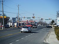
(Salisbury Bypass), where the route briefly becomes a four-lane divided highway
. Past US 13, MD 12 crosses into Salisbury at the Johnson Road intersection. Here, the route heads north through commercial areas, becoming a six-lane road with a center left-turn lane, two southbound travel lanes and one northbound travel lane. In addition, there is one lane in each direction devoted to right turns. At the intersection with College Avenue/Beaglin Park Drive, the road narrows to four-lane with each direction consisting of one travel lane and a right-turn lane. This configuration eventually ends and MD 12 becomes a two-lane road again, leaving the corporate limits of Salisbury. Upon entering Salisbury again, the route becomes municipally maintained and continues past a mix of residences and businesses with some industrial establishments. MD 12 crosses over a branch of the Wicomico River
near the Salisbury city park, which contains the Salisbury Zoo
, before ending at Main Street a short distance to the east of U.S. Route 13 Business
(Salisbury Boulevard) near downtown Salisbury.
designated the highway from Stockton to Snow Hill as one of the original state roads in 1909. By 1910, the highway was paved within Stockton, between Snow Hill and Indiantown, and for about 2 miles (3.2 km) south from the city limit of Salisbury. The highway was paved from Snow Hill to a point north of Girdletree by 1917. The all-weather road between Snow Hill and Stockton was completed by 1921. The Snow Hill–Salisbury road was under construction by 1923. By 1927, MD 12 had been assigned to the highway despite a 4 miles (6.4 km) gap remaining from just north of the Wicomico–Worcester county line south toward Snow Hill. That gap was filled by 1930. In addition, MD 12's present northern terminus at Main Street, including the bridge across the South Prong of the Wicomico River, was constructed in 1928 and 1929. The highway had previously entered Salisbury along Lincoln Avenue and Division Street. The final portion of MD 12 was completed between Stockton and the Virginia state line by 1933. In addition, the present bridge across the Pocomoke River was completed in 1932. MD 12 was widened and straightened from Stockton to Salisbury between 1951 and 1954.
s on MD 12 where it intersects the ramps to US 113. The proposed cost needed to build this interchange is $24.2 million, which includes engineering, acquisition of land, and the actual construction.
!County
!Location
!Mile
!Intersection
!Notes
|-
|rowspan=6|Worcester
|
|0.00
|
|Southern terminus; Virginia state line
|-
|Stockton
|3.31
|
|
|-
|rowspan=4|Snow Hill
|11.04
|
|
|-
|12.55
|
|South end of US 113 Bus. overlap
|-
|12.73
|
|North end of US 113 Bus. overlap
|-
|13.95
|
|
|-
|rowspan=2|Wicomico
|rowspan=2|Salisbury
|27.99
| – Norfolk, VA
, Dover, DE
|Interchange
|-
|30.63
|Main Street
|Northern terminus
U.S. state
A U.S. state is any one of the 50 federated states of the United States of America that share sovereignty with the federal government. Because of this shared sovereignty, an American is a citizen both of the federal entity and of his or her state of domicile. Four states use the official title of...
of Maryland
Maryland
Maryland is a U.S. state located in the Mid Atlantic region of the United States, bordering Virginia, West Virginia, and the District of Columbia to its south and west; Pennsylvania to its north; and Delaware to its east...
. The route runs 30.63 mi (49.29 km) from the Virginia
Virginia
The Commonwealth of Virginia , is a U.S. state on the Atlantic Coast of the Southern United States. Virginia is nicknamed the "Old Dominion" and sometimes the "Mother of Presidents" after the eight U.S. presidents born there...
border south of Stockton
Stockton, Maryland
Stockton is a census-designated place in Worcester County, Maryland, United States. The population was 143 at the 2000 census.-History:...
, Worcester County
Worcester County, Maryland
-2010:Whereas according to the 2010 U.S. Census Bureau:*82.0% White*13.6% Black*0.3% Native American*1.1% Asian*0.0% Native Hawaiian or Pacific Islander*1.7% Two or more races*1.3% Other races*3.2% Hispanic or Latino -2000:...
, where it continues into Virginia as State Route 679, north to Main Street in the city of Salisbury
Salisbury, Maryland
-Demographics:Salisbury is the principal city of the Salisbury-Ocean Pines CSA, a Combined Statistical Area that includes the Salisbury metropolitan area and the Ocean Pines micropolitan area , which had a combined population of 176,657 at the 2010 census.As of the census of 2000, there were...
in Wicomico County
Wicomico County, Maryland
As of the census of 2010, there were 98,733 people, 37,220 households, and 24,172 families residing in the county. The population density was 261.7 people per square mile . There were 41,192 housing units at an average density of 109.2 per square mile...
. The route is known as Snow Hill Road for most of its length and passes mostly through areas of woods and farms as well as the communities of Stockton, Girdletree
Girdletree, Maryland
Girdletree is a census-designated place in Worcester County, Maryland, United States. The population was 117 at the 2000 census.-Geography:Girdletree is located at ....
, and Snow Hill
Snow Hill, Maryland
Snow Hill is a town in Worcester County, Maryland, United States. The population was 2,409 at the 2000 census. It is the county seat of Worcester County.-History:...
. MD 12 intersects several roads including Maryland Route 366
Maryland Route 366
Maryland Route 366 is a state highway in the U.S. state of Maryland. Known for much of its length as Stockton Road, the state highway runs from U.S. Route 13 Business in Pocomoke City east to the entrance of George Island Landing on Chincoteague Bay...
in Stockton, U.S. Route 113
U.S. Route 113
U.S. Route 113 is a spur of US 13 in the U.S. states of Maryland and Delaware. The U.S. Highway runs from US 13 in Pocomoke City, Maryland north to Delaware Route 1 in Milford, Delaware...
and U.S. Route 113 Business
U.S. Route 113 Business (Snow Hill, Maryland)
U.S. Route 113 Business is a business route of U.S. Route 113 in the U.S. state of Maryland. The highway runs between junctions with US 113 on the south and north sides of Snow Hill, the county seat of Worcester County. US 113 Business is the old alignment of US 113 through Snow Hill...
in Snow Hill, Maryland Route 354
Maryland Route 354
Maryland Route 354 is a state highway in the U.S. state of Maryland. The state highway runs from MD 12 in Indiantown north to MD 346 in Willards. MD 354 parallels the Pocomoke River, connecting eastern Wicomico County and northwestern Worcester with Snow Hill. The state highway was first...
in Indiantown, and U.S. Route 13
U.S. Route 13 in Maryland
U.S. Route 13 is a U.S. Highway running from Fayetteville, North Carolina north to Morrisville, Pennsylvania. In the U.S. state of Maryland, the route runs from the Virginia border south of Pocomoke City in Worcester County north to the Delaware border in Delmar, Wicomico County, where the route...
near Salisbury. Portions of MD 12 near Snow Hill and Stockton existed as unnumbered state roads by 1910. When the first state highways in Maryland were designated by 1927, MD 12 was assigned to run from Stockton north to Salisbury. By 1940, the route was extended south to the Virginia border and a small incomplete portion between Snow Hill and Salisbury was finished. A dumbbell interchange is planned at the US 113 intersection; however, this project is currently on hold.
Worcester County
Maryland Route 12 heads north from the Virginia border on Snow Hill Road, which is a two-lane undivided road. The road continues south into Virginia as State Route 679 (Fleming Road). From the border, the route passes through a mix of woodland and farmland with a few residences in southern Worcester CountyWorcester County, Maryland
-2010:Whereas according to the 2010 U.S. Census Bureau:*82.0% White*13.6% Black*0.3% Native American*1.1% Asian*0.0% Native Hawaiian or Pacific Islander*1.7% Two or more races*1.3% Other races*3.2% Hispanic or Latino -2000:...
before reaching Stockton
Stockton, Maryland
Stockton is a census-designated place in Worcester County, Maryland, United States. The population was 143 at the 2000 census.-History:...
. Here, MD 12 passes by homes and crosses Maryland Route 366
Maryland Route 366
Maryland Route 366 is a state highway in the U.S. state of Maryland. Known for much of its length as Stockton Road, the state highway runs from U.S. Route 13 Business in Pocomoke City east to the entrance of George Island Landing on Chincoteague Bay...
(George Island Landing Road). Upon leaving Stockton, the roads heads back into rural areas and passes near the E.A. Vaughn Wildlife Management Area before reaching the residential community of Girdletree
Girdletree, Maryland
Girdletree is a census-designated place in Worcester County, Maryland, United States. The population was 117 at the 2000 census.-Geography:Girdletree is located at ....
. Past Girdletree, the road continues to the east of a tract of the Pocomoke State Forest as it approaches Snow Hill
Snow Hill, Maryland
Snow Hill is a town in Worcester County, Maryland, United States. The population was 2,409 at the 2000 census. It is the county seat of Worcester County.-History:...
, the county seat of Worcester County. Just south of Snow Hill, the route intersects U.S. Route 113
U.S. Route 113
U.S. Route 113 is a spur of US 13 in the U.S. states of Maryland and Delaware. The U.S. Highway runs from US 13 in Pocomoke City, Maryland north to Delaware Route 1 in Milford, Delaware...
(Worcester Highway).
Past this intersection, the road enters Snow Hill, where it becomes Church Street, and heads into inhabited areas with some businesses. In the center of town, MD 12 intersects U.S. Route 113 Business
U.S. Route 113 Business (Snow Hill, Maryland)
U.S. Route 113 Business is a business route of U.S. Route 113 in the U.S. state of Maryland. The highway runs between junctions with US 113 on the south and north sides of Snow Hill, the county seat of Worcester County. US 113 Business is the old alignment of US 113 through Snow Hill...
(Market Street) and turns east to form a concurrency
Concurrency (road)
A concurrency, overlap, or coincidence in a road network is an instance of one physical road bearing two or more different highway, motorway, or other route numbers...
with that route, passing through the downtown area. Within the downtown, the road passes by the Julia A. Purnell Museum
Julia A. Purnell Museum
The Julia A. Purnell Museum is located at 208 West Market Street, Snow Hill, Maryland, United States. The building that houses the museum was originally the St. Agnes Catholic Church built in 1891. The museum exhibits 500 years of local history....
and the Worcester County Courthouse. Here, MD 12 turns north to follow Washington Street, crossing the Pocomoke River
Pocomoke River
The Pocomoke River stretches approximately from southern Delaware through southeastern Maryland in the United States. At its mouth, the river is essentially an arm of Chesapeake Bay, whereas the upper river flows through a series of relatively inaccessible wetlands called the Great Cypress Swamp,...
out of downtown Snow Hill on a drawbridge
Drawbridge
A drawbridge is a type of movable bridge typically associated with the entrance of a castle surrounded by a moat. The term is often used to describe all different types of movable bridges, like bascule bridges and lift bridges.-Castle drawbridges:...
. From here, the route becomes Snow Hill Road again and turns northwest. The road heads into agricultural areas with some residences before Indiantown, where MD 12 intersects the southern terminus of Maryland Route 354
Maryland Route 354
Maryland Route 354 is a state highway in the U.S. state of Maryland. The state highway runs from MD 12 in Indiantown north to MD 346 in Willards. MD 354 parallels the Pocomoke River, connecting eastern Wicomico County and northwestern Worcester with Snow Hill. The state highway was first...
(Whiton Road), which runs north to Willards
Willards, Maryland
Willards is a town in Wicomico County, Maryland, United States. The population was 938 at the 2000 census. It is included in the Salisbury, Maryland Metropolitan Statistical Area.-Geography:...
. Past this intersection, the route turns more to the west and heads through a mix of farmland and woodland with occasional homes. The road turns to the northwest again and runs to the northeast of more tracts of the Pocomoke State Forest. The Pocomoke State Forest is known for its loblolly trees and cypress swamps and is popular with fishing and hunting.
Wicomico County
Wicomico County, Maryland
As of the census of 2010, there were 98,733 people, 37,220 households, and 24,172 families residing in the county. The population density was 261.7 people per square mile . There were 41,192 housing units at an average density of 109.2 per square mile...
, where it continues north through woods and farms with some residences. The route turns northwest again before heading into a mix of residential areas and farm fields on the outskirts of Salisbury
Salisbury, Maryland
-Demographics:Salisbury is the principal city of the Salisbury-Ocean Pines CSA, a Combined Statistical Area that includes the Salisbury metropolitan area and the Ocean Pines micropolitan area , which had a combined population of 176,657 at the 2010 census.As of the census of 2000, there were...
. The road comes to a partial cloverleaf interchange with U.S. Route 13
U.S. Route 13 in Maryland
U.S. Route 13 is a U.S. Highway running from Fayetteville, North Carolina north to Morrisville, Pennsylvania. In the U.S. state of Maryland, the route runs from the Virginia border south of Pocomoke City in Worcester County north to the Delaware border in Delmar, Wicomico County, where the route...
(Salisbury Bypass), where the route briefly becomes a four-lane divided highway
Divided Highway
Divided Highway is a compilation album by American rock band The Doobie Brothers, released in 2003. . All tracks are taken from the albums Cycles and Brotherhood .-Track listing:...
. Past US 13, MD 12 crosses into Salisbury at the Johnson Road intersection. Here, the route heads north through commercial areas, becoming a six-lane road with a center left-turn lane, two southbound travel lanes and one northbound travel lane. In addition, there is one lane in each direction devoted to right turns. At the intersection with College Avenue/Beaglin Park Drive, the road narrows to four-lane with each direction consisting of one travel lane and a right-turn lane. This configuration eventually ends and MD 12 becomes a two-lane road again, leaving the corporate limits of Salisbury. Upon entering Salisbury again, the route becomes municipally maintained and continues past a mix of residences and businesses with some industrial establishments. MD 12 crosses over a branch of the Wicomico River
Wicomico River (Maryland eastern shore)
The Wicomico River is a tributary of the Chesapeake Bay on the eastern shore of Maryland. It drains an area of low marshlands and farming country in the middle Delmarva Peninsula. The name "Wicomico" derives from the words wicko mekee, meaning "a place where houses are built," apparently...
near the Salisbury city park, which contains the Salisbury Zoo
Salisbury Zoo
The Salisbury Zoological Park, commonly referred to as the Salisbury Zoo, is a zoo located on the Delmarva Peninsula in the Salisbury, Maryland city park...
, before ending at Main Street a short distance to the east of U.S. Route 13 Business
U.S. Route 13 Business (Salisbury, Maryland)
U.S. Route 13 Business is a business route of U.S. Route 13 in the U.S. state of Maryland. The highway runs between US 13 south of Fruitland and US 13 and US 50 on the north side of Salisbury...
(Salisbury Boulevard) near downtown Salisbury.
History
The portion of MD 12 south of Snow Hill was part of an old post road from the 18th century that ran the length of the Delmarva Peninsula. The section of the state highway north of Snow Hill is the descendant of the Old Snow Hill Road from Salisbury whose original bridge across the Pocomoke River dates to 1878. The Maryland State Roads CommissionMaryland State Highway Administration
The Maryland State Highway Administration is the state agency responsible for maintaining Maryland numbered highways outside of Baltimore City...
designated the highway from Stockton to Snow Hill as one of the original state roads in 1909. By 1910, the highway was paved within Stockton, between Snow Hill and Indiantown, and for about 2 miles (3.2 km) south from the city limit of Salisbury. The highway was paved from Snow Hill to a point north of Girdletree by 1917. The all-weather road between Snow Hill and Stockton was completed by 1921. The Snow Hill–Salisbury road was under construction by 1923. By 1927, MD 12 had been assigned to the highway despite a 4 miles (6.4 km) gap remaining from just north of the Wicomico–Worcester county line south toward Snow Hill. That gap was filled by 1930. In addition, MD 12's present northern terminus at Main Street, including the bridge across the South Prong of the Wicomico River, was constructed in 1928 and 1929. The highway had previously entered Salisbury along Lincoln Avenue and Division Street. The final portion of MD 12 was completed between Stockton and the Virginia state line by 1933. In addition, the present bridge across the Pocomoke River was completed in 1932. MD 12 was widened and straightened from Stockton to Salisbury between 1951 and 1954.
Future
An interchange is planned between MD 12 and US 113 south of Snow Hill in order to improve safety and traffic flow as a follow up to widening US 113; however, the project is currently on hold. This proposed interchange is to be a dumbbell interchange, a variation of the diamond interchange with two roundaboutRoundabout
A roundabout is the name for a road junction in which traffic moves in one direction around a central island. The word dates from the early 20th century. Roundabouts are common in many countries around the world...
s on MD 12 where it intersects the ramps to US 113. The proposed cost needed to build this interchange is $24.2 million, which includes engineering, acquisition of land, and the actual construction.
Junction list
{|class=wikitable!County
!Location
!Mile
!Intersection
!Notes
|-
|rowspan=6|Worcester
Worcester County, Maryland
-2010:Whereas according to the 2010 U.S. Census Bureau:*82.0% White*13.6% Black*0.3% Native American*1.1% Asian*0.0% Native Hawaiian or Pacific Islander*1.7% Two or more races*1.3% Other races*3.2% Hispanic or Latino -2000:...
|
|0.00
|
|Southern terminus; Virginia state line
|-
|Stockton
Stockton, Maryland
Stockton is a census-designated place in Worcester County, Maryland, United States. The population was 143 at the 2000 census.-History:...
|3.31
|
|
|-
|rowspan=4|Snow Hill
Snow Hill, Maryland
Snow Hill is a town in Worcester County, Maryland, United States. The population was 2,409 at the 2000 census. It is the county seat of Worcester County.-History:...
|11.04
|
|
|-
|12.55
|
|South end of US 113 Bus. overlap
|-
|12.73
|
|North end of US 113 Bus. overlap
|-
|13.95
|
|
|-
|rowspan=2|Wicomico
Wicomico County, Maryland
As of the census of 2010, there were 98,733 people, 37,220 households, and 24,172 families residing in the county. The population density was 261.7 people per square mile . There were 41,192 housing units at an average density of 109.2 per square mile...
|rowspan=2|Salisbury
Salisbury, Maryland
-Demographics:Salisbury is the principal city of the Salisbury-Ocean Pines CSA, a Combined Statistical Area that includes the Salisbury metropolitan area and the Ocean Pines micropolitan area , which had a combined population of 176,657 at the 2010 census.As of the census of 2000, there were...
|27.99
| – Norfolk, VA
Norfolk, Virginia
Norfolk is an independent city in the Commonwealth of Virginia in the United States. With a population of 242,803 as of the 2010 Census, it is Virginia's second-largest city behind neighboring Virginia Beach....
, Dover, DE
Dover, Delaware
The city of Dover is the capital and second largest city in the U.S. state of Delaware. It is also the county seat of Kent County, and the principal city of the Dover, Delaware Metropolitan Statistical Area, which encompasses all of Kent County. It is located on the St. Jones River in the Delaware...
|Interchange
|-
|30.63
|Main Street
|Northern terminus