
Maryland Route 352
Encyclopedia
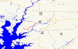
Maryland Route 352 is an east–west state highway
in the U.S. state
of Maryland
. The state highway runs 10.03 miles (16.1 km) between intersections with MD 349
near Bivalve
on the west and Catchpenny on the east. The Whitehaven Road portion of MD 352 was constructed as a state highway from Catchpenny west to Green Hill Creek in the early 1930s. The state highway was extended south to Whitehaven
, the north landing of the Whitehaven Ferry, by 1946. The Capitola Road portion of MD 352 was originally designated MD 385 in the late 1940s and absorbed into MD 352 in the 1960s.
and farmland before veering east at Trinity Church Road, which leads to Ellis Bay Wildlife Management Area
. The state highway continues east until a perpendicular intersection with Whitehaven Road. Whitehaven Road south leads to Whitehaven, which features the Whitehaven Historic District
, including the Whitehaven Hotel
, and the Whitehaven Ferry, a cable ferry
across the Wicomico River to Mount Vernon
in Somerset County
. MD 352 turns north onto Whitehaven Road and passes St. Bartholomew's Episcopal Church
. The state highway curves northeast through the Chesapeake Forest Lands, then goes by an area of intensive agriculture as the highway crosses Green Hill Creek. MD 352 passes the Green Hill Yacht and Country Club shortly before reaching its eastern terminus at MD 349 in Catchpenny.
.
{| class=wikitable
!Location
!Mile
!Destinations
!Notes
|-
|Bivalve
|0.00
|
|Western terminus
|-
|Whitehaven
|3.44
|Whitehaven Road south – Whitehaven Ferry
|MD 352 turns north onto Whitehaven Road; Whitehaven Road south is old alignment of MD 352
|-
|Catchpenny
|10.03
|
|Eastern terminus
State highway
State highway, state road or state route can refer to one of three related concepts, two of them related to a state or provincial government in a country that is divided into states or provinces :#A...
in the U.S. state
U.S. state
A U.S. state is any one of the 50 federated states of the United States of America that share sovereignty with the federal government. Because of this shared sovereignty, an American is a citizen both of the federal entity and of his or her state of domicile. Four states use the official title of...
of Maryland
Maryland
Maryland is a U.S. state located in the Mid Atlantic region of the United States, bordering Virginia, West Virginia, and the District of Columbia to its south and west; Pennsylvania to its north; and Delaware to its east...
. The state highway runs 10.03 miles (16.1 km) between intersections with MD 349
Maryland Route 349
Maryland Route 349 is a state highway in the U.S. state of Maryland. Known as Nanticoke Road, the state highway runs from a dead end in Nanticoke east to U.S. Route 50 Business in Salisbury. The first segment of MD 349 was constructed by 1910 west of Salisbury...
near Bivalve
Bivalve, Maryland
Bivalve is a small town along the eastern shore of the lower Nanticoke River, near its mouth on the Chesapeake Bay, in Wicomico County, Maryland, United States. Bivalve takes its name from the oyster, upon which the town's economy once depended. Currently there is no economy to speak of. It is...
on the west and Catchpenny on the east. The Whitehaven Road portion of MD 352 was constructed as a state highway from Catchpenny west to Green Hill Creek in the early 1930s. The state highway was extended south to Whitehaven
Whitehaven, Maryland
Whitehaven is an unincorporated community in Wicomico County, Maryland, United States.Whitehaven is home to one of the few remaining public ferries in Maryland, and was once a thriving settlement which included stores, a shipyard, and the Whitehaven Hotel. It is the location of the Whitehaven...
, the north landing of the Whitehaven Ferry, by 1946. The Capitola Road portion of MD 352 was originally designated MD 385 in the late 1940s and absorbed into MD 352 in the 1960s.
Route description
MD 352 begins at an intersection with MD 349 (Nanticoke Road) known as Cox's Corner near Bivalve. The state highway heads southeast as two-lane Capitola Road. MD 352 passes by the historic Yellow Brick HouseYellow Brick House
The Yellow Brick House, or Moorfield, is a historic home located at Bilvalve, Wicomico County, Maryland, United States. It is a Federal-style two story brick dwelling built about 1810...
and farmland before veering east at Trinity Church Road, which leads to Ellis Bay Wildlife Management Area
Ellis Bay Wildlife Management Area
Ellis Bay Wildlife Management Area is a Wildlife Management Area in Wicomico County, Maryland.-External links:*...
. The state highway continues east until a perpendicular intersection with Whitehaven Road. Whitehaven Road south leads to Whitehaven, which features the Whitehaven Historic District
Whitehaven Historic District
Whitehaven Historic District is a national historic district in Whitehaven, Wicomico County, Maryland. It is located at the end of Whitehaven Road on the north bank of the Wicomico River. The ferry that crosses the river here has been in continuous operation since 1688 or earlier...
, including the Whitehaven Hotel
Whitehaven Hotel
Whitehaven Hotel is a historic hotel located at Whitehaven, Wicomico County, Maryland, United States. It is a three-story, U-shaped, steeply pitches mansard-roofed Second Empire-style frame structure. The center core of the hotel is a Federal side hall / parlor dwelling, erected around 1810-1815...
, and the Whitehaven Ferry, a cable ferry
Cable ferry
A cable ferry is guided and in many cases propelled across a river or other larger body of water by cables connected to both shores. They are also called chain ferries, floating bridges, or punts....
across the Wicomico River to Mount Vernon
Mount Vernon, Maryland
Mount Vernon is a census-designated place in Somerset County, Maryland, United States. The population was 761 at the 2000 census. It is included in the Salisbury, Maryland Metropolitan Statistical Area.-Geography:...
in Somerset County
Somerset County, Maryland
-2010:Whereas according to the 2010 U.S. Census Bureau:*53.5% White*42.3% Black*0.3% Native American*0.7% Asian*0.0% Native Hawaiian or Pacific Islander*1.7% Two or more races*1.5% Other races*3.3% Hispanic or Latino -2000:...
. MD 352 turns north onto Whitehaven Road and passes St. Bartholomew's Episcopal Church
St. Bartholomew's Episcopal Church (Quantico, Maryland)
St. Bartholomew's Episcopal Church, also known as Green Hill Church, is a historic Episcopal church located at Quantico, Wicomico County, Maryland. It is a single-story, Flemish bond gable-front brick church built in 1733. Adjacent to the church are several marked burials with 18th and 19th century...
. The state highway curves northeast through the Chesapeake Forest Lands, then goes by an area of intensive agriculture as the highway crosses Green Hill Creek. MD 352 passes the Green Hill Yacht and Country Club shortly before reaching its eastern terminus at MD 349 in Catchpenny.
History
The first portion of MD 352 was constructed between 1930 and 1933 between Catchpenny and Green Hill Creek. The portion of Whitehaven Road south of Green Hill was maintained as a county highway until the MD 352 designation was extended to Whitehaven by 1946. The Capitola Road segment was designated MD 385 in 1949. The segment of Whitehaven Road south of Capitola Road was returned to county maintenance and MD 352 assumed its present course, taking over the course of MD 385, in 1964.Junction list
The entire route is in Wicomico CountyWicomico County, Maryland
As of the census of 2010, there were 98,733 people, 37,220 households, and 24,172 families residing in the county. The population density was 261.7 people per square mile . There were 41,192 housing units at an average density of 109.2 per square mile...
.
{| class=wikitable
!Location
!Mile
!Destinations
!Notes
|-
|Bivalve
Bivalve, Maryland
Bivalve is a small town along the eastern shore of the lower Nanticoke River, near its mouth on the Chesapeake Bay, in Wicomico County, Maryland, United States. Bivalve takes its name from the oyster, upon which the town's economy once depended. Currently there is no economy to speak of. It is...
|0.00
|
|Western terminus
|-
|Whitehaven
Whitehaven, Maryland
Whitehaven is an unincorporated community in Wicomico County, Maryland, United States.Whitehaven is home to one of the few remaining public ferries in Maryland, and was once a thriving settlement which included stores, a shipyard, and the Whitehaven Hotel. It is the location of the Whitehaven...
|3.44
|Whitehaven Road south – Whitehaven Ferry
|MD 352 turns north onto Whitehaven Road; Whitehaven Road south is old alignment of MD 352
|-
|Catchpenny
|10.03
|
|Eastern terminus