
Maryland Route 349
Encyclopedia
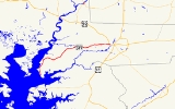
Maryland Route 349 is a state highway
in the U.S. state
of Maryland
. Known as Nanticoke Road, the state highway runs 22.32 miles (35.9 km) from a dead end in Nanticoke
east to U.S. Route 50 Business
(US 50 Business) in Salisbury
. The first segment of MD 349 was constructed by 1910 west of Salisbury. The modern highway reached Catchpenny by 1919, Bivalve
by 1925, and its western terminus by 1933. The only major change to MD 349 since is a realignment near Salisbury in the mid 1950s.
and Wicomico River
as the two rivers enter Tangier Sound
. The state highway heads north as a two-lane road through the village of Nanticoke. North of Jesterville Road, MD 349 crosses Windsor Creek and Dunn Creek. The state highway continues through the hamlet of Bivalve, where the highway negotiates two sharp curves. MD 349 curves to the east as it leaves Bivalve, intersecting Tyaskin Road, which was formerly MD 541. The state highway passes the west end of MD 352
(Capitola Road), then turns northeast past the Chesapeake Forest Lands and traverses Wetipquin Creek.
At the hamlet of Royal Oak, MD 349 turns east toward its intersections with MD 347
(Quantico Road) in Quantico and with the other end of MD 352 (Whitehaven Road) in Catchpenny, which heads south to the Whitehaven Ferry, a cable ferry
that crosses the Wicomico River. After passing North Upper Ferry Road, which heads toward the Upper Ferry cable ferry crossing of the Wicomico River, the state highway begins to pass residential subdivisions and crosses Rockawalking Creek. Just west of Salisbury, the old alignment of MD 349, MD 815 (Old Quantico Road), splits to the east when MD 349 veers southeast. The state highway expands to a four-lane undivided highway before intersecting Parsons Road and the other end of MD 815. Upon crossing Mitchell Pond, MD 349 enters the city of Salisbury and municipal maintenance begins. Main Street splits to the southeast from the eastbound direction of MD 349 immediately before the state highway reaches its eastern terminus at US 50 Business (Salisbury Parkway). The highway continues on the opposite side of the intersection as Isabella Street.
.
{| class=wikitable
!Location
!Mile
!Destinations
!Notes
|-
|rowspan=1|Nanticoke
|0.00
|Dead end
|rowspan=1|Western terminus
|-
|rowspan=2|Bivalve
|6.04
|Tyaskin Road north – Tyaskin
|rowspan=1|Former MD 541
|-
|7.58
|
|-
|rowspan=1|Quantico
|15.14
|
|-
|rowspan=2|Catchpenny
|15.77
|
|-
|17.46
|North Upper Ferry Road south – Upper Ferry
|-
|rowspan=5|Salisbury
|21.45
|
|rowspan=2|Old alignment of MD 349
|-
|22.15
|
|-
|22.29
|Main Street east
|rowspan=1|Old alignment of US 50
|-
|rowspan=2|22.32
|
|rowspan=2|Eastern terminus
|-
|Isabella Street east
State highway
State highway, state road or state route can refer to one of three related concepts, two of them related to a state or provincial government in a country that is divided into states or provinces :#A...
in the U.S. state
U.S. state
A U.S. state is any one of the 50 federated states of the United States of America that share sovereignty with the federal government. Because of this shared sovereignty, an American is a citizen both of the federal entity and of his or her state of domicile. Four states use the official title of...
of Maryland
Maryland
Maryland is a U.S. state located in the Mid Atlantic region of the United States, bordering Virginia, West Virginia, and the District of Columbia to its south and west; Pennsylvania to its north; and Delaware to its east...
. Known as Nanticoke Road, the state highway runs 22.32 miles (35.9 km) from a dead end in Nanticoke
Nanticoke, Maryland
Nanticoke is an unincorporated community in Wicomico County, Maryland, United States.-References:...
east to U.S. Route 50 Business
U.S. Route 50 Business (Salisbury, Maryland)
U.S. Route 50 Business is a business route of U.S. Route 50 in the U.S. state of Maryland. The highway runs between US 50 on the northwest side of Salisbury and US 50 on the east side of Salisbury, the county seat of Wicomico County...
(US 50 Business) in Salisbury
Salisbury, Maryland
-Demographics:Salisbury is the principal city of the Salisbury-Ocean Pines CSA, a Combined Statistical Area that includes the Salisbury metropolitan area and the Ocean Pines micropolitan area , which had a combined population of 176,657 at the 2010 census.As of the census of 2000, there were...
. The first segment of MD 349 was constructed by 1910 west of Salisbury. The modern highway reached Catchpenny by 1919, Bivalve
Bivalve, Maryland
Bivalve is a small town along the eastern shore of the lower Nanticoke River, near its mouth on the Chesapeake Bay, in Wicomico County, Maryland, United States. Bivalve takes its name from the oyster, upon which the town's economy once depended. Currently there is no economy to speak of. It is...
by 1925, and its western terminus by 1933. The only major change to MD 349 since is a realignment near Salisbury in the mid 1950s.
Route description
MD 349 begins at a dead end at Jones Creek near the confluence of the Nanticoke RiverNanticoke River
The Nanticoke River is a major tributary of the Chesapeake Bay on the Delmarva Peninsula. It rises in southern Kent County, Delaware, flows through Sussex County, Delaware, and forms the boundary between Dorchester County, Maryland and Wicomico County, Maryland. The river course proceeds southwest...
and Wicomico River
Wicomico River (Maryland eastern shore)
The Wicomico River is a tributary of the Chesapeake Bay on the eastern shore of Maryland. It drains an area of low marshlands and farming country in the middle Delmarva Peninsula. The name "Wicomico" derives from the words wicko mekee, meaning "a place where houses are built," apparently...
as the two rivers enter Tangier Sound
Tangier Sound
Tangier Sound is a sound of the Chesapeake Bay bounded on the west by Tangier Island in Virginia, and Smith Island and South Marsh Island in Maryland, by Deal Island in Maryland on the north, and the mainland of the Eastern Shore of Maryland and Pocomoke Sound on the east...
. The state highway heads north as a two-lane road through the village of Nanticoke. North of Jesterville Road, MD 349 crosses Windsor Creek and Dunn Creek. The state highway continues through the hamlet of Bivalve, where the highway negotiates two sharp curves. MD 349 curves to the east as it leaves Bivalve, intersecting Tyaskin Road, which was formerly MD 541. The state highway passes the west end of MD 352
Maryland Route 352
Maryland Route 352 is an east–west state highway in the U.S. state of Maryland. The state highway runs between intersections with MD 349 near Bivalve on the west and Catchpenny on the east. The Whitehaven Road portion of MD 352 was constructed as a state highway from Catchpenny west to...
(Capitola Road), then turns northeast past the Chesapeake Forest Lands and traverses Wetipquin Creek.
At the hamlet of Royal Oak, MD 349 turns east toward its intersections with MD 347
Maryland Route 347
Maryland Route 347 is a state highway in the U.S. state of Maryland. The state highway runs from MD 349 in Quantico north to U.S. Route 50 in Hebron. MD 347 was constructed as a modern highway in Hebron in the mid 1910s...
(Quantico Road) in Quantico and with the other end of MD 352 (Whitehaven Road) in Catchpenny, which heads south to the Whitehaven Ferry, a cable ferry
Cable ferry
A cable ferry is guided and in many cases propelled across a river or other larger body of water by cables connected to both shores. They are also called chain ferries, floating bridges, or punts....
that crosses the Wicomico River. After passing North Upper Ferry Road, which heads toward the Upper Ferry cable ferry crossing of the Wicomico River, the state highway begins to pass residential subdivisions and crosses Rockawalking Creek. Just west of Salisbury, the old alignment of MD 349, MD 815 (Old Quantico Road), splits to the east when MD 349 veers southeast. The state highway expands to a four-lane undivided highway before intersecting Parsons Road and the other end of MD 815. Upon crossing Mitchell Pond, MD 349 enters the city of Salisbury and municipal maintenance begins. Main Street splits to the southeast from the eastbound direction of MD 349 immediately before the state highway reaches its eastern terminus at US 50 Business (Salisbury Parkway). The highway continues on the opposite side of the intersection as Isabella Street.
History
MD 349 was paved from Salisbury west to Rockawalking Creek by 1910. The improved highway extended west to Catchpenny in 1919 and to Royal Oak in 1921. MD 349 was complete to Wetipquin Creek in 1923 and to Bivalve in 1925. The highway was complete to its western terminus in Nanticoke in 1933. Beyond the widening of the road from Salisbury to Tyaskin Road in 1950, the only significant change in MD 349 is the realignment of the highway just west of Salisbury in 1956, with MD 815 assigned to the old alignment.Junction list
The entire route is in Wicomico CountyWicomico County, Maryland
As of the census of 2010, there were 98,733 people, 37,220 households, and 24,172 families residing in the county. The population density was 261.7 people per square mile . There were 41,192 housing units at an average density of 109.2 per square mile...
.
{| class=wikitable
!Location
!Mile
!Destinations
!Notes
|-
|rowspan=1|Nanticoke
Nanticoke, Maryland
Nanticoke is an unincorporated community in Wicomico County, Maryland, United States.-References:...
|0.00
|Dead end
|rowspan=1|Western terminus
|-
|rowspan=2|Bivalve
Bivalve, Maryland
Bivalve is a small town along the eastern shore of the lower Nanticoke River, near its mouth on the Chesapeake Bay, in Wicomico County, Maryland, United States. Bivalve takes its name from the oyster, upon which the town's economy once depended. Currently there is no economy to speak of. It is...
|6.04
|Tyaskin Road north – Tyaskin
Tyaskin, Maryland
Tyaskin is an unincorporated community in Wicomico County, Maryland, United States.-References:...
|rowspan=1|Former MD 541
|-
|7.58
|
|-
|rowspan=1|Quantico
Quantico, Maryland
Quantico is an unincorporated community in Wicomico County, Maryland, United States, along the former stage route from Vienna to the port of Whitehaven on the Wicomico River. It consists of approximately 35 homes on the Quantico Creek. The community lies four miles from Hebron, Maryland along...
|15.14
|
|-
|rowspan=2|Catchpenny
|15.77
|
|-
|17.46
|North Upper Ferry Road south – Upper Ferry
|-
|rowspan=5|Salisbury
Salisbury, Maryland
-Demographics:Salisbury is the principal city of the Salisbury-Ocean Pines CSA, a Combined Statistical Area that includes the Salisbury metropolitan area and the Ocean Pines micropolitan area , which had a combined population of 176,657 at the 2010 census.As of the census of 2000, there were...
|21.45
|
|rowspan=2|Old alignment of MD 349
|-
|22.15
|
|-
|22.29
|Main Street east
|rowspan=1|Old alignment of US 50
|-
|rowspan=2|22.32
|
|rowspan=2|Eastern terminus
|-
|Isabella Street east