
Maryland Route 260
Encyclopedia
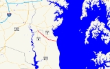
Maryland Route 260 is a state highway
in Calvert County and Anne Arundel County, Maryland
. Route 260 starts at the northern border of Calvert and Anne Arundel counties, branching off from Maryland Route 4
by way of an overpass
interchange. It then proceeds diagonally southeast as a two-lane road, where it briefly passes through Anne Arundel County before re-entering Calvert County and intersecting with Maryland Route 2
in Owings
. Past Owings
, Route 260 takes a turn to the direct east and becomes a four-lane dual highway. Route 260 remains a dual highway until reaching the Chesapeake Beach
town limits, where it returns to two lanes and ends at Maryland Route 261
near the Chesapeake Bay
.
Along with Route 2-4
, Route 260 is the only other four-lane divided highway in Calvert County.
via an interchange atop the Calvert
/Anne Arundel
border. It turns southeast, passing through the wooded country of Calvert County on the two-lane, shouldered Chesapeake Beach Road. The route serves mostly side roads leading to residential areas and farmland in this area. Eventually the route crosses the Anne Arundel County border and passes through that county for 1.38 miles (2.22 km). Once it returns to Calvert County, the route spreads to four lanes undivided momentarily to meet a wide ramped intersection with MD 2
(Solomons Island Road), which also spreads to four lanes in this respect.
MD 260 passes through Owings
just beyond this intersection, intersecting MD 778 within the community. It continues through another short stretch of woods and farmland before it meets an interchange with Mount Harmony Road. Here, MD 260 turns east and upgrades into a four-lane divided highway. This stretch of the highway is largely wooded as well; various roads branch from the highway and follow it, providing direct access to homes. As it near Chesapeake Beach
, the route narrows to two lanes wide with a shared left-turn lane. It passes through the town, intersecting several streets before coming to its eastern end at MD 261
(Bayside Road), mere feet from the shore of the Chesapeake Bay
.
Highway
A highway is any public road. In American English, the term is common and almost always designates major roads. In British English, the term designates any road open to the public. Any interconnected set of highways can be variously referred to as a "highway system", a "highway network", or a...
in Calvert County and Anne Arundel County, Maryland
Maryland
Maryland is a U.S. state located in the Mid Atlantic region of the United States, bordering Virginia, West Virginia, and the District of Columbia to its south and west; Pennsylvania to its north; and Delaware to its east...
. Route 260 starts at the northern border of Calvert and Anne Arundel counties, branching off from Maryland Route 4
Maryland Route 4
Maryland Route 4 is a state highway in the U.S. state of Maryland. The state highway runs from MD 5 in Leonardtown north to Southern Avenue at the Washington, D.C. border, past which the highway continues as Pennsylvania Avenue...
by way of an overpass
Overpass
An overpass is a bridge, road, railway or similar structure that crosses over another road or railway...
interchange. It then proceeds diagonally southeast as a two-lane road, where it briefly passes through Anne Arundel County before re-entering Calvert County and intersecting with Maryland Route 2
Maryland Route 2
Maryland Route 2 is the longest state highway in the U.S. state of Maryland. The route runs from Solomons Island in Calvert County north to an intersection with U.S. Route 1 and U.S. Route 40 Truck in Baltimore...
in Owings
Owings, Maryland
Owings is a census-designated place in Calvert County, Maryland, United States. The population was 1,325 at the 2000 census.-Geography:Owings is located at ....
. Past Owings
Owings, Maryland
Owings is a census-designated place in Calvert County, Maryland, United States. The population was 1,325 at the 2000 census.-Geography:Owings is located at ....
, Route 260 takes a turn to the direct east and becomes a four-lane dual highway. Route 260 remains a dual highway until reaching the Chesapeake Beach
Chesapeake Beach, Maryland
Chesapeake Beach is a town in Calvert County, Maryland, United States. Its major attractions include a Railway Museum & Trail, the Chesapeake Beach Water Park, marinas, piers, charter boat fishing, and a Veterans Memorial Park...
town limits, where it returns to two lanes and ends at Maryland Route 261
Maryland Route 261
Maryland Route 261 is a state highway in the U.S. state of Maryland. The route runs from Maryland Route 263 near Parran north to Maryland Route 778 in Friendship...
near the Chesapeake Bay
Chesapeake Bay
The Chesapeake Bay is the largest estuary in the United States. It lies off the Atlantic Ocean, surrounded by Maryland and Virginia. The Chesapeake Bay's drainage basin covers in the District of Columbia and parts of six states: New York, Pennsylvania, Delaware, Maryland, Virginia, and West...
.
Along with Route 2-4
Maryland Route 4
Maryland Route 4 is a state highway in the U.S. state of Maryland. The state highway runs from MD 5 in Leonardtown north to Southern Avenue at the Washington, D.C. border, past which the highway continues as Pennsylvania Avenue...
, Route 260 is the only other four-lane divided highway in Calvert County.
Route description
Maryland Route 260 begins in the west as it branches off Maryland Route 4Maryland Route 4
Maryland Route 4 is a state highway in the U.S. state of Maryland. The state highway runs from MD 5 in Leonardtown north to Southern Avenue at the Washington, D.C. border, past which the highway continues as Pennsylvania Avenue...
via an interchange atop the Calvert
Calvert County, Maryland
Calvert County is a county located in the U.S. state of Maryland. It occupies the Calvert Peninsula which is bordered on the east by the Chesapeake Bay and on the west by the Patuxent River. Calvert County is part of the Southern Maryland region. Calvert County's residents are among the highest...
/Anne Arundel
Anne Arundel County, Maryland
Anne Arundel County is a county located in the U.S. state of Maryland. It is named for Anne Arundell , a member of the ancient family of Arundells in Cornwall, England and the wife of Cæcilius Calvert, 2nd Baron Baltimore. Its county seat is Annapolis, which is also the capital of the state...
border. It turns southeast, passing through the wooded country of Calvert County on the two-lane, shouldered Chesapeake Beach Road. The route serves mostly side roads leading to residential areas and farmland in this area. Eventually the route crosses the Anne Arundel County border and passes through that county for 1.38 miles (2.22 km). Once it returns to Calvert County, the route spreads to four lanes undivided momentarily to meet a wide ramped intersection with MD 2
Maryland Route 2
Maryland Route 2 is the longest state highway in the U.S. state of Maryland. The route runs from Solomons Island in Calvert County north to an intersection with U.S. Route 1 and U.S. Route 40 Truck in Baltimore...
(Solomons Island Road), which also spreads to four lanes in this respect.
MD 260 passes through Owings
Owings, Maryland
Owings is a census-designated place in Calvert County, Maryland, United States. The population was 1,325 at the 2000 census.-Geography:Owings is located at ....
just beyond this intersection, intersecting MD 778 within the community. It continues through another short stretch of woods and farmland before it meets an interchange with Mount Harmony Road. Here, MD 260 turns east and upgrades into a four-lane divided highway. This stretch of the highway is largely wooded as well; various roads branch from the highway and follow it, providing direct access to homes. As it near Chesapeake Beach
Chesapeake Beach, Maryland
Chesapeake Beach is a town in Calvert County, Maryland, United States. Its major attractions include a Railway Museum & Trail, the Chesapeake Beach Water Park, marinas, piers, charter boat fishing, and a Veterans Memorial Park...
, the route narrows to two lanes wide with a shared left-turn lane. It passes through the town, intersecting several streets before coming to its eastern end at MD 261
Maryland Route 261
Maryland Route 261 is a state highway in the U.S. state of Maryland. The route runs from Maryland Route 263 near Parran north to Maryland Route 778 in Friendship...
(Bayside Road), mere feet from the shore of the Chesapeake Bay
Chesapeake Bay
The Chesapeake Bay is the largest estuary in the United States. It lies off the Atlantic Ocean, surrounded by Maryland and Virginia. The Chesapeake Bay's drainage basin covers in the District of Columbia and parts of six states: New York, Pennsylvania, Delaware, Maryland, Virginia, and West...
.
Junction list
| County | Location | Mile | Intersection | Notes |
|---|---|---|---|---|
| Calvert Calvert County, Maryland Calvert County is a county located in the U.S. state of Maryland. It occupies the Calvert Peninsula which is bordered on the east by the Chesapeake Bay and on the west by the Patuxent River. Calvert County is part of the Southern Maryland region. Calvert County's residents are among the highest... |
Lyons Creek Lyons Creek, Maryland Lyons Creek is an tributary of the Patuxent River in Maryland. Lyons Creek serves as the border between southern Anne Arundel County, Maryland and northern Calvert County, Maryland.... |
0.00 | , Washington Washington, D.C. Washington, D.C., formally the District of Columbia and commonly referred to as Washington, "the District", or simply D.C., is the capital of the United States. On July 16, 1790, the United States Congress approved the creation of a permanent national capital as permitted by the U.S. Constitution.... |
Interchange, western terminus |
| No major junctions in Anne Arundel County Anne Arundel County, Maryland Anne Arundel County is a county located in the U.S. state of Maryland. It is named for Anne Arundell , a member of the ancient family of Arundells in Cornwall, England and the wife of Cæcilius Calvert, 2nd Baron Baltimore. Its county seat is Annapolis, which is also the capital of the state... |
||||
| Calvert Calvert County, Maryland Calvert County is a county located in the U.S. state of Maryland. It occupies the Calvert Peninsula which is bordered on the east by the Chesapeake Bay and on the west by the Patuxent River. Calvert County is part of the Southern Maryland region. Calvert County's residents are among the highest... |
Owings Owings, Maryland Owings is a census-designated place in Calvert County, Maryland, United States. The population was 1,325 at the 2000 census.-Geography:Owings is located at .... |
3.94 | ||
| 4.20 | ||||
| Chesapeake Beach Chesapeake Beach, Maryland Chesapeake Beach is a town in Calvert County, Maryland, United States. Its major attractions include a Railway Museum & Trail, the Chesapeake Beach Water Park, marinas, piers, charter boat fishing, and a Veterans Memorial Park... |
8.51 | Eastern terminus | ||