
Maryland Route 122
Encyclopedia
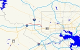
Maryland Route 122 better known locally as Security Boulevard, is a six-lane highway that runs near the Social Security Administration
complex located in Woodlawn
in western Baltimore County, Maryland
. The numbered route came into existence in 1990, though the road was there long before.
complex. It begins at an intersection with Rolling Road, following Security Boulevard on a six-lane, divided alignment. Here, the route directly faces Security Square Mall
and provides direct access to it. The route then interchanges with I-695 at an interchange which incorporates elements of a diamond and cloverleaf; the ramps for the I-70
to I-695 are inside the south end of this interchange with no direct access to I-70. However, access to I-70 is available in the westbound direction via Ingleside Avenue.
MD 122 continues through the business area, exiting it and curving south through a forest, toward Leakin Park. Access to Leakin Park is available via either North Forest Park Avenue to Windsor Mill Road
or via Cooks Lane and Briarclift Road. The route runs through Dead Run Park, where it interchanges with the national eastern terminus of Interstate 70. The route continues until it touches the Baltimore City
line, where it changes to Cooks Lane (ending the MD 122 designation there) and terminates at the Edmondson Avenue portion of US 40
.
Social Security Administration
The United States Social Security Administration is an independent agency of the United States federal government that administers Social Security, a social insurance program consisting of retirement, disability, and survivors' benefits...
complex located in Woodlawn
Woodlawn, Baltimore County, Maryland
Woodlawn is an unincorporated community and a census-designated place in Baltimore County, Maryland, United States. The population was 36,079 at the 2000 census. It is home to both the headquarters of the Social Security Administration as well as the Centers for Medicare and Medicaid Services...
in western Baltimore County, Maryland
Baltimore County, Maryland
Baltimore County is a county located in the northern part of the US state of Maryland. In 2010, its population was 805,029. It is part of the Baltimore-Washington Metropolitan Area. Its county seat is Towson. The name of the county was derived from the barony of the Proprietor of the Maryland...
. The numbered route came into existence in 1990, though the road was there long before.
Route description
The route is a six lane divided highway that serves the Social Security AdministrationSocial Security Administration
The United States Social Security Administration is an independent agency of the United States federal government that administers Social Security, a social insurance program consisting of retirement, disability, and survivors' benefits...
complex. It begins at an intersection with Rolling Road, following Security Boulevard on a six-lane, divided alignment. Here, the route directly faces Security Square Mall
Security Square Mall
Security Square Mall is a large mall in the suburbs of Baltimore, Maryland, United States. The mall features over 100 stores and restaurants, as well as a food court, with Burlington Coat Factory, Macy's, Old Navy and Sears serving as anchor stores. One section of the mall, Seoul Plaza, used to...
and provides direct access to it. The route then interchanges with I-695 at an interchange which incorporates elements of a diamond and cloverleaf; the ramps for the I-70
Interstate 70 in Maryland
Interstate 70 is a part of the Interstate Highway System that runs from Cove Fort, Utah to Baltimore, Maryland. In Maryland, the Interstate Highway runs from the Pennsylvania state line in Hancock east to the Interstate's eastern terminus near its junction with I-695 at a park and ride in...
to I-695 are inside the south end of this interchange with no direct access to I-70. However, access to I-70 is available in the westbound direction via Ingleside Avenue.
MD 122 continues through the business area, exiting it and curving south through a forest, toward Leakin Park. Access to Leakin Park is available via either North Forest Park Avenue to Windsor Mill Road
Windsor Mill Road
Windsor Mill Road is a road that runs through parts of Baltimore, Maryland and its western suburb Woodlawn. The road starts as a one way street named Edgewood Street, then makes a slight left corner and becomes Windsor Mill Road...
or via Cooks Lane and Briarclift Road. The route runs through Dead Run Park, where it interchanges with the national eastern terminus of Interstate 70. The route continues until it touches the Baltimore City
Baltimore
Baltimore is the largest independent city in the United States and the largest city and cultural center of the US state of Maryland. The city is located in central Maryland along the tidal portion of the Patapsco River, an arm of the Chesapeake Bay. Baltimore is sometimes referred to as Baltimore...
line, where it changes to Cooks Lane (ending the MD 122 designation there) and terminates at the Edmondson Avenue portion of US 40
U.S. Route 40 in Maryland
U.S. Route 40 in the U.S. state of Maryland runs from western Maryland to Cecil County in the state's northeastern corner. With a total length of over , it is the longest numbered highway in Maryland. Almost half of the road overlaps with Interstate 68 or Interstate 70, while the old alignment...
.
Junction list
| County | Location | Mile | Destinations | Notes |
|---|---|---|---|---|
| Baltimore Baltimore County, Maryland Baltimore County is a county located in the northern part of the US state of Maryland. In 2010, its population was 805,029. It is part of the Baltimore-Washington Metropolitan Area. Its county seat is Towson. The name of the county was derived from the barony of the Proprietor of the Maryland... |
Woodlawn Woodlawn, Baltimore County, Maryland Woodlawn is an unincorporated community and a census-designated place in Baltimore County, Maryland, United States. The population was 36,079 at the 2000 census. It is home to both the headquarters of the Social Security Administration as well as the Centers for Medicare and Medicaid Services... |
0.00 | Western terminus | |
| 0.15 | Lord Baltimore Drive | entrance to Security Square Mall Security Square Mall Security Square Mall is a large mall in the suburbs of Baltimore, Maryland, United States. The mall features over 100 stores and restaurants, as well as a food court, with Burlington Coat Factory, Macy's, Old Navy and Sears serving as anchor stores. One section of the mall, Seoul Plaza, used to... |
||
| 0.27 | Belmont Avenue | |||
| 0.58 | Interchange | |||
| 0.58 | ||||
| 1.09 | Woodlawn Drive - to Gwynn Oak Avenue | |||
| 1.26 | West Perimeter Drive - Social Security Administration Social Security Administration The United States Social Security Administration is an independent agency of the United States federal government that administers Social Security, a social insurance program consisting of retirement, disability, and survivors' benefits... |
|||
| 1.38 | Gwynn Oak Avenue | |||
| 1.59 | East Perimeter Drive - Social Security Administration Social Security Administration The United States Social Security Administration is an independent agency of the United States federal government that administers Social Security, a social insurance program consisting of retirement, disability, and survivors' benefits... |
|||
| 2.07 | Colonial Road / Kernan Drive | |||
| 2.59 | Ingleside Avenue / North Forest Park Avenue – Leakin Park | |||
| 2.78 | last eastbound exit on I-70; eastbound ramps link to Park and Ride Park and ride Park and ride facilities are car parks with connections to public transport that allow commuters and other people wishing to travel into city centres to leave their vehicles and transfer to a bus, rail system , or carpool for the rest of their trip... and Leakin Park |
|||
| Baltimore City | 2.96 | Eastern terminus Roadway continues as Cooks Lane to US 40 |
||