

Martian dichotomy
Encyclopedia
Geology of Mars
The geology of Mars is the scientific study of the surface, crust, and interior of the planet Mars. It emphasizes the composition, structure, history, and physical processes that shape the planet. It is fully analogous to the field of terrestrial geology. In planetary science, the term geology is...
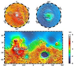
is a sharp contrast, known as the Martian dichotomy, between the rugged southern highlands and the relatively smooth northern basins. The two hemispheres differ in elevation by 1 to 3 km. The average thickness of the Martian crust is 45 km, with 32 km in the northern lowlands region, and 58 km in the southern highlands.
The boundary between the two regions is quite complex in places. One distinctive type of topography is called fretted terrain
Fretted terrain
Fretted terrain is a type of surface feature common to certain areas of Mars and discovered in Mariner 9 images. It lies between two different types of terrain...
. It contains mesas, knobs, and flat-floored valleys having walls about a mile high. Around many of the mesas and knobs are lobate debris apron
Lobate Debris Apron
Lobate debris aprons are geological features on Mars, first seen by the Viking Orbiters, consisting of piles of rock debris below cliffs. These features have a convex topography and a gentle slope from cliffs or escarpments, which suggest flow away from the steep source cliff...
s that have been shown to be rock-covered glaciers.
Many large river valleys cut through the dichotomy.
The Martian dichotomy boundary includes the regions called Deuteronilus Mensae
Deuteronilus Mensae
Deuteronilus Mensae is a region on Mars 937 km across and centered at . It covers 344° -325° West and 40°-48° North. Deuteronilus region lies just to the north of Arabia Terra and is included in the Ismenius Lacus quadrangle. It is along the dichotomy boundary, that is between the old,...
, Protonilus Mensae
Protonilus Mensae
Protonilus Mensae is an area of Mars in the Ismenius Lacus quadrangle. It is centered on the coordinates of 43.86° N and 49.4° E. Its western and eastern longitudes are 37° E and 59.7° E. North and south latitudes are 47.06° N and 39.87° N. Protonilus Mensae is between Deuteronilus Mensae and...
, and Nilosyrtis Mensae
Nilosyrtis Mensae
Nilosyrtis Mensae is an area of Mars in the Casius quadrangle. It is centered on the coodinates of 36.87° N and 67.9° E. Its western and eastern longitudes are 51.1° E and 74.4° E. North and south latitudes are 36.87° N and 29.61° N. Nilosyrtis Mensae is just to the east of Protonilus Mensae...
. All three regions have been studied extensively because they contain landforms believed to have been produced by the movement of ice.
The northern lowlands comprise about one-third of the surface of Mars and are relatively flat, with occasional impact craters. The other two-thirds of the Martian surface are the highlands of the southern hemisphere. The difference in elevation between the hemispheres is dramatic. Because of the density of impact craters, scientists believe the southern hemisphere to be far older than the northern plains. The heavily cratered southern highlands date back to the period of heavy bombardment.
Three major hypotheses have been proposed for the origin of the crustal dichotomy: endogenic (by mantle processes), single impact, or multiple impact. Both impact-related hypotheses involve processes that could have occurred before the end of the primordial bombardment, implying that the crustal dichotomy has its origins early in the history of Mars.
Single Impact Hypothesis
A single mega-impact would produce a very large, circular depression in the crust. The proposed depression has been named the Borealis BasinNorth Polar Basin (Mars)
The North Polar Basin, or Borealis basin, is a large basin in the northern hemisphere of Mars that covers 40% of the planet. Chryse Planitia, the landing site of the Viking 1 lander, is a bay which opens into this basin....
. However, most estimations of the shape of the lowlands area produce a shape that in places dramatically deviates from the circular shape. Additional processes could create those deviations from circularity. Also if the proposed Borealis basin is a depression created by an impact, it would make it the largest impact crater in the Solar System. An object that large could have hit Mars sometime during the process of the Solar System accretion.
It is expected that the impact of such magnitude would have produced an ejecta blanket that should be found in areas around the lowland. However, if the impact occurred around 4.5 Ga, erosional factors could explain the absence of the ejecta blanket. Also, the mega-impact could have scattered a large portion of the debris into outer space and across the southern hemisphere. Geologic evidence of the debris would provide very convincing support for this hypothesis.
A 2008 study provided additional research that supports the single giant impact theory. In the past tracing of the impact boundaries was complicated by the presence of the Tharsis volcanic rise. The Tharsis volcanic rise buried the proposed dichotomy boundary under 30 km of basalt. The researchers at MIT and Jet Propulsion Lab at CIT have been able to use gravity and topography of Mars to constrain the location of the dichotomy beneath the Tharsis rise, thus creating an elliptical model of the dichotomy boundary. The elliptical shape of the Borealis Basin further supports the Single Impact Hypothesis. This hypothesis is favored by many due to its relative simplicity, and because impacts of that magnitude were known to occur early in the history of the Solar System.
Endogenic Origin Hypothesis
It is believed that plate tectonic processes could have been active on Mars early in the planet’s history. Large-scale redistribution of lithospheric crustal material is known to be caused by plate tectonic processes on Earth. Even though it is still not entirely clear how mantle processes affect plate tectonics on Earth, mantle convection is believed to be involved as cells or plumes. Since endogenic processes of Earth are still to be completely understood, studying of similar processes on Mars is very difficult.The dichotomy could be created at the time of the creation of the Martian core. The roughly circular shape of the lowland could then be attributed to plume-like first-order overturn which could occur in the process of rapid core formation. There is evidence for internally driven tectonic events in the vicinity of the lowland area that clearly occurred at the end of the early bombardment phase.
A 2005 study suggests that degree-1 mantle convection could have created the dichotomy. Degree-1 mantle convection is a convective process in which one hemisphere is dominated by an
upwelling, while the other hemisphere is downwelling.
Some of the evidence is the abundance of extensive fracturing and igneous activity of late Noachian to early Hesperian age. A counter argument to the endogenic hypothesis is the possibility of those tectonic events occurring in the Borealis basin due to the post-impact weakening of the crust.
In order to further support the endogenic origin hypothesis geologic evidence of faulting and flexing of the crust prior to the end of the primordial bombardment is needed.
Multiple Impact Hypothesis
The multiple impact hypothesis is supported by correlation of segments of the dichotomy with the rims of several large impact basins. But there are large parts of the Borealis Basin outside the rims of those impact basins. If the Martian lowlands were formed by the multiple basins then their inner ejecta and rims should stand above upland elevations. The rims and ejecta blankets of the lowland impact craters are still much below the upland areas. There are also areas in the lowlands that are outside any of the impact basins, these areas must be overlain by multiple ejecta blankets and should stand at elevations similar to the original planetary surface. That clearly is not the case either.One approach explaining the absence of ejecta blankets infers that no ejecta was ever present ). Absence of ejecta could be caused by a large impactor scattering the ejecta into outer space. Another approach proposed the formation of the dichotomy by cooling at depth and crustal loading by later volcanism.
The multiple-impact hypothesis is also statistically unfavorable, it is unlikely that multiple impacts basins occur and overlap primarily in the northern hemisphere.
See also
- Geology of MarsGeology of MarsThe geology of Mars is the scientific study of the surface, crust, and interior of the planet Mars. It emphasizes the composition, structure, history, and physical processes that shape the planet. It is fully analogous to the field of terrestrial geology. In planetary science, the term geology is...
- AreographyAreographyThe geography of Mars, also known as areography, entails the delineation and characterization of regions on Mars. Martian geography is mainly focused on what is called physical geography on Earth; that is the distribution of physical features across Mars and their cartographic...
- Water on MarsWater on MarsWater on Mars is a psychedelic rock and electronic music group from Quebec City, Québec, Canada. The music trio is led by Philippe Navarro, guitarist, vocalist, arranger, producer, principal lyricist, and music composer....
- Fretted terrainFretted terrainFretted terrain is a type of surface feature common to certain areas of Mars and discovered in Mariner 9 images. It lies between two different types of terrain...
- Lobate Debris ApronLobate Debris ApronLobate debris aprons are geological features on Mars, first seen by the Viking Orbiters, consisting of piles of rock debris below cliffs. These features have a convex topography and a gentle slope from cliffs or escarpments, which suggest flow away from the steep source cliff...
- Deuteronilus MensaeDeuteronilus MensaeDeuteronilus Mensae is a region on Mars 937 km across and centered at . It covers 344° -325° West and 40°-48° North. Deuteronilus region lies just to the north of Arabia Terra and is included in the Ismenius Lacus quadrangle. It is along the dichotomy boundary, that is between the old,...
- Protonilus MensaeProtonilus MensaeProtonilus Mensae is an area of Mars in the Ismenius Lacus quadrangle. It is centered on the coordinates of 43.86° N and 49.4° E. Its western and eastern longitudes are 37° E and 59.7° E. North and south latitudes are 47.06° N and 39.87° N. Protonilus Mensae is between Deuteronilus Mensae and...
- Nilosyrtis MensaeNilosyrtis MensaeNilosyrtis Mensae is an area of Mars in the Casius quadrangle. It is centered on the coodinates of 36.87° N and 67.9° E. Its western and eastern longitudes are 51.1° E and 74.4° E. North and south latitudes are 36.87° N and 29.61° N. Nilosyrtis Mensae is just to the east of Protonilus Mensae...
- GlacierGlacierA glacier is a large persistent body of ice that forms where the accumulation of snow exceeds its ablation over many years, often centuries. At least 0.1 km² in area and 50 m thick, but often much larger, a glacier slowly deforms and flows due to stresses induced by its weight...
- Glaciers on MarsGlaciers on MarsGlaciers formed much of the observable surface in large areas of Mars. Most of the area in high latitudes, especially the Ismenius Lacus quadrangle, is believed to still contain enormous amounts of water ice. Recent evidence has led many planetary scientists to believe that water ice still exists...
External links
- Google Mars - Google MapsGoogle MapsGoogle Maps is a web mapping service application and technology provided by Google, free , that powers many map-based services, including the Google Maps website, Google Ride Finder, Google Transit, and maps embedded on third-party websites via the Google Maps API...