
Mark Trail Wilderness
Encyclopedia

Mark Trail
Mark Trail is a newspaper comic strip created by the American cartoonist Ed Dodd. Introduced April 15, 1946, the strip centers on environmental and ecological themes. In 2006, King Features syndicated the strip to nearly 175 newspapers....
, a daily newspaper
Newspaper
A newspaper is a scheduled publication containing news of current events, informative articles, diverse features and advertising. It usually is printed on relatively inexpensive, low-grade paper such as newsprint. By 2007, there were 6580 daily newspapers in the world selling 395 million copies a...
comic strip
Comic strip
A comic strip is a sequence of drawings arranged in interrelated panels to display brief humor or form a narrative, often serialized, with text in balloons and captions....
created by the American
United States
The United States of America is a federal constitutional republic comprising fifty states and a federal district...
cartoonist
Cartoonist
A cartoonist is a person who specializes in drawing cartoons. This work is usually humorous, mainly created for entertainment, political commentary or advertising...
Ed Dodd
Ed Dodd
Edward Benton Dodd was a 20th century American cartoonist known for his Mark Trail comic strip.-Early years:...
. The Wilderness is located within the borders of the Chattahoochee National Forest in White
White County, Georgia
White County is a county located in the northeast corner of the U.S. state of Georgia. It was created on December 22, 1857, from part of Habersham County. The county was named for Newton County Representative David T. White, who helped a Habersham representative successfully attain passage of an...
, Towns
Towns County, Georgia
Towns County is a county located in the U.S. state of Georgia. It was created on March 6, 1856. As of the 2000 census, the population was 9,319. The 2007 Census Estimate shows a population of 10,894. Its county seat is Hiawassee.-History:...
, and Union
Union County, Georgia
Union County is a county located in the U.S. state of Georgia. As of 2000, the population was 17,289. The 2007 Census Estimate shows a population of 20,968. The county seat is Blairsville.Its Sole commissioner is Lamar Paris, who has served since 2001....
counties, Georgia
Georgia (U.S. state)
Georgia is a state located in the southeastern United States. It was established in 1732, the last of the original Thirteen Colonies. The state is named after King George II of Great Britain. Georgia was the fourth state to ratify the United States Constitution, on January 2, 1788...
. The Wilderness is managed by the United States Forest Service
United States Forest Service
The United States Forest Service is an agency of the United States Department of Agriculture that administers the nation's 155 national forests and 20 national grasslands, which encompass...
and is part of the National Wilderness Preservation System
National Wilderness Preservation System
The National Wilderness Preservation System of the United States protects federally managed land areas designated for preservation in their natural condition. It was established by the Wilderness Act upon the signature of President Lyndon B. Johnson on September 3, 1964...
.
The highest elevation
Elevation
The elevation of a geographic location is its height above a fixed reference point, most commonly a reference geoid, a mathematical model of the Earth's sea level as an equipotential gravitational surface ....
in the Mark Trail Wilderness is the 4045 feet (1,233 m) peak of Horsetrough Mountain
Horsetrough Mountain
Horsetrough Mountain, with a summit elevation of , is located in Union and White counties in northeastern Georgia, USA. It is also within the boundaries of the Chattahoochee National Forest and is part of the Mark Trail Wilderness. The Eastern Continental Divide follows the main ridge line that...
. Fourteen miles (21 km) of the Appalachian Trail
Appalachian Trail
The Appalachian National Scenic Trail, generally known as the Appalachian Trail or simply the AT, is a marked hiking trail in the eastern United States extending between Springer Mountain in Georgia and Mount Katahdin in Maine. It is approximately long...
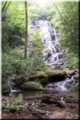
cross the Wilderness. The Wilderness features other peaks and Horsetrough Falls
Horsetrough Falls
Horsetrough Falls are located on one of the flanks of Horsetrough Mountain in Union County, Georgia. This 70 foot waterfall is located on a creek that is part of the headwaters of the Chattahoochee River and is in the Mark Trail Wilderness. There is an observation platform at the falls which can...
on the headwaters of the Chattahoochee River
Chattahoochee River
The Chattahoochee River flows through or along the borders of the U.S. states of Georgia, Alabama, and Florida. It is a tributary of the Apalachicola River, a relatively short river formed by the confluence of the Chattahoochee and Flint Rivers and emptying into Apalachicola Bay in the Gulf of...
. The Tray Mountain Wilderness
Tray Mountain Wilderness
The Tray Mountain Wilderness was designated in 1986 and currently consists of . The Wilderness is located within the borders of the Chattahoochee National Forest in Habersham, Rabun, Towns and White counties, Georgia and is managed in the Chattooga Ranger District...
is located across State Route 75 to the east.