
Marble, Colorado
Encyclopedia

Gunnison County, Colorado
Gunnison County is the fifth most extensive of the 64 counties of the state of Colorado in the United States. The county population was 15,324 at the 2010 census. The county was named for John W. Gunnison, a United States Army officer and captain in the Army Topographical Engineers, who surveyed...
, Colorado
Colorado
Colorado is a U.S. state that encompasses much of the Rocky Mountains as well as the northeastern portion of the Colorado Plateau and the western edge of the Great Plains...
, United States
United States
The United States of America is a federal constitutional republic comprising fifty states and a federal district...
. The population was 131 at the 2010 census.
History
The town of Marble was first incorporated in 1899. Marble remains a statutory townColorado municipalities
The U.S. state of Colorado currently has 271 active incorporated municipalities, including 196 towns, 73 cities, and two consolidated city and county governments.-Municipal government:...
within the state of Colorado as of 2007.
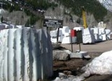
The quarry
The town is the location of a historic YuleYule Marble
Yule Marble is a type of metamorphed limestone found only in the Yule Creek Valley, in the West Elk Mountains of Colorado, just south of the town of Marble, Colorado . Quarried today at 9,300 feet above sea level, Yule Marble is famous for its uniform pure white consistency, lacking, for the most...
Marble
Marble
Marble is a metamorphic rock composed of recrystallized carbonate minerals, most commonly calcite or dolomite.Geologists use the term "marble" to refer to metamorphosed limestone; however stonemasons use the term more broadly to encompass unmetamorphosed limestone.Marble is commonly used for...
quarry along the mountains that began operations in the late 19th century, and from which the town draws its name. The marble of the quarry is considered to be of exceptional quality and has been used for the Tomb of the Unknowns
Tomb of the Unknowns
The Tomb of the Unknowns is a monument dedicated to American service members who have died without their remains being identified. It is located in Arlington National Cemetery in the United States...
, as well as for parts of the Lincoln Memorial
Lincoln Memorial
The Lincoln Memorial is an American memorial built to honor the 16th President of the United States, Abraham Lincoln. It is located on the National Mall in Washington, D.C. The architect was Henry Bacon, the sculptor of the main statue was Daniel Chester French, and the painter of the interior...
in Washington, D.C.
Washington, D.C.
Washington, D.C., formally the District of Columbia and commonly referred to as Washington, "the District", or simply D.C., is the capital of the United States. On July 16, 1790, the United States Congress approved the creation of a permanent national capital as permitted by the U.S. Constitution....
, and civic buildings in San Francisco. It was also used for the construction of the Equitable Building
Equitable Building (Manhattan)
The Equitable Building is a 38-story office building in New York City, located at 120 Broadway in the Financial District of Lower Manhattan. A landmark engineering achievement as a skyscraper, it was designed by Ernest R. Graham and completed in 1915...
, a historically important early skyscraper
Skyscraper
A skyscraper is a tall, continuously habitable building of many stories, often designed for office and commercial use. There is no official definition or height above which a building may be classified as a skyscraper...
in New York City
New York City
New York is the most populous city in the United States and the center of the New York Metropolitan Area, one of the most populous metropolitan areas in the world. New York exerts a significant impact upon global commerce, finance, media, art, fashion, research, technology, education, and...
.
The quarry has enjoyed a renaissance since its acquisition in 2004 by Polycor, a Canadian-based dimension stone company. In spite of significant transportation costs, this high-quality stone is now exported in large quantities to Europe and Asia for transformation and use throughout the world, as well as being sold into the US market.
Tourism
In the late 20th century and the 21st century, Marble has become a summer tourist destination, benefiting from the quarry's renown. It is also the gateway to the nearby CrystalCrystal, Colorado
Crystal is a ghost town in a valley on the upper Crystal River in Gunnison County, Colorado, United States, on a four-wheel-drive road between Marble and Crested Butte...
townsite. It is the site of the Marble/marble sculpting symposium http://www.marbleinst.org held every summer since 1988.
Seven sites within Marble have been listed on the National Register of Historic Places
National Register of Historic Places
The National Register of Historic Places is the United States government's official list of districts, sites, buildings, structures, and objects deemed worthy of preservation...
: http://www.nr.nps.gov/iwisapi/explorer.dll?IWS_SCHEMA=NRIS1&IWS_LOGIN=1&IWS_REPORT=100000042
- Haxby House
- William S. Parry House
- St. Paul's ChurchMarble Community ChurchMarble Community Church, formerly called St. Paul's Church, is a historic Episcopal church at 123 State Street in Marble, Colorado. The church's main building was originally the building of the St. John’s Episcopal Chapel, which was built in Aspen, Colorado in 1886...
- Marble City State Bank building
- Marble High School
- Marble Mill Site
- Marble Town Hall
Geography
Marble is located at 39°4′20"N 107°11′22"W (39.072274, -107.189516).According to the United States Census Bureau
United States Census Bureau
The United States Census Bureau is the government agency that is responsible for the United States Census. It also gathers other national demographic and economic data...
, the town has a total area of 0.4 square miles (1 km²), all of it land.
The community is located in a valley of the upper Crystal River
Crystal River (Colorado)
The Crystal River is a tributary of the Roaring Fork River, approximately 40 mi long, in western Colorado in the United States. It drains a glacial valley, called the Valley of the Coal Miners, south of Carbondale which was historically known as a center of coal mining in southwestern Colorado...
along the Elk Mountains
Elk Mountains (Colorado)
The Elk Mountains are a high, rugged mountain range in the Rocky Mountains of west-central Colorado in the United States. The mountains sit on the western side of the Continental Divide, largely in southern Pitkin and northern Gunnison counties, in the area southwest of Aspen, south of the Roaring...
, accessible by a paved road from State Highway 133
Colorado State Highway 133
State Highway 133 is a long north–south byway connecting State Highway 82 to the north and State Highway 92 to the south, and travels through the towns of Hotchkiss, Somerset, Redstone, and Carbondale. Highway 133 travels over a significant mountain pass on the northern end, called McClure Pass,...
. Unlike most of Gunnison County, the town is located on the north side of McClure Pass
McClure Pass
McClure Pass is a high mountain pass in the Rocky Mountains of western Colorado in the United States.- Overview :...
, and is thus somewhat separated geographically from the rest of the county.
Demographics
As of the censusCensus
A census is the procedure of systematically acquiring and recording information about the members of a given population. It is a regularly occurring and official count of a particular population. The term is used mostly in connection with national population and housing censuses; other common...
of 2000, there were 105 people, 45 households, and 27 families residing in the town. The population density
Population density
Population density is a measurement of population per unit area or unit volume. It is frequently applied to living organisms, and particularly to humans...
was 282.2 people per square mile (109.6/km²). There were 74 housing units at an average density of 198.9 per square mile (77.2/km²). The racial makeup of the town was 99.05% White, 0.95% from other races
Race (United States Census)
Race and ethnicity in the United States Census, as defined by the Federal Office of Management and Budget and the United States Census Bureau, are self-identification data items in which residents choose the race or races with which they most closely identify, and indicate whether or not they are...
. Hispanic or Latino of any race were 0.95% of the population.
There were 45 households out of which 22.2% had children under the age of 18 living with them, 60.0% were married couples
Marriage
Marriage is a social union or legal contract between people that creates kinship. It is an institution in which interpersonal relationships, usually intimate and sexual, are acknowledged in a variety of ways, depending on the culture or subculture in which it is found...
living together, and 40.0% were non-families. 26.7% of all households were made up of individuals and 4.4% had someone living alone who was 65 years of age or older. The average household size was 2.33 and the average family size was 2.89.
In the town the population was spread out with 20.0% under the age of 18, 2.9% from 18 to 24, 27.6% from 25 to 44, 42.9% from 45 to 64, and 6.7% who were 65 years of age or older. The median age was 44 years. For every 100 females there were 118.8 males. For every 100 females age 18 and over, there were 133.3 males.
The median income for a household in the town was $46,094, and the median income for a family was $47,292. Males had a median income of $29,375 versus $20,000 for females. The per capita income
Per capita income
Per capita income or income per person is a measure of mean income within an economic aggregate, such as a country or city. It is calculated by taking a measure of all sources of income in the aggregate and dividing it by the total population...
for the town was $18,509. There were no families and 2.7% of the population living below the poverty line, including no under eighteens and none of those over 64.