
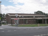
Marayong, New South Wales
Encyclopedia
Marayong is a suburb
of Sydney
, in the state of New South Wales
, Australia
. Marayong is located 38 kilometres west of the Sydney central business district
, in the local government area of the City of Blacktown
and is part of the Greater Western Sydney
region.
Around 1900–1905, large areas were subdivided and market garden
s and poultry farms were established. The area was part of Quakers Hill
but in 1926 the Marayong Progress Association applied to have Marayong made a suburb, in its own right.
The area was mostly rural until the 1960s. Housing Commission (public housing) estates, opened in the 1960s, marked the urbanisation of the suburb predominantly south of the railway line. In addition, an industrial area was also released north of the railway line.
(6.5%) and the number of Catholics in Marayong (40.6%) was well above the national average.
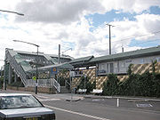 Marayong railway station is on the Richmond branch of the Western Line
of the CityRail
network. It provides services out to Richmond
and in to the city via Blacktown
and Parramatta
.
Richmond Road
marks the southern boundary of the suburb and provides links to Blacktown
and Richmond
while the Westlink M7
curls around the suburb and can be accessed via the Sunnyholt Road intersection at Kings Park
or the Richmond Road intersection at Dean Park
.
Suburb
The word suburb mostly refers to a residential area, either existing as part of a city or as a separate residential community within commuting distance of a city . Some suburbs have a degree of administrative autonomy, and most have lower population density than inner city neighborhoods...
of Sydney
Sydney
Sydney is the most populous city in Australia and the state capital of New South Wales. Sydney is located on Australia's south-east coast of the Tasman Sea. As of June 2010, the greater metropolitan area had an approximate population of 4.6 million people...
, in the state of New South Wales
New South Wales
New South Wales is a state of :Australia, located in the east of the country. It is bordered by Queensland, Victoria and South Australia to the north, south and west respectively. To the east, the state is bordered by the Tasman Sea, which forms part of the Pacific Ocean. New South Wales...
, Australia
Australia
Australia , officially the Commonwealth of Australia, is a country in the Southern Hemisphere comprising the mainland of the Australian continent, the island of Tasmania, and numerous smaller islands in the Indian and Pacific Oceans. It is the world's sixth-largest country by total area...
. Marayong is located 38 kilometres west of the Sydney central business district
Sydney central business district
The Sydney central business district is the main commercial centre of Sydney, New South Wales, Australia. It extends southwards for about 3 kilometres from Sydney Cove, the point of first European settlement. Its north–south axis runs from Circular Quay in the north to Central railway station in...
, in the local government area of the City of Blacktown
City of Blacktown
The City of Blacktown is a Local Government Area in the heart of Western Sydney, situated on the Cumberland Plain, approximately 35 km from Sydney CBD. It is bounded by the Local Government Areas of Penrith, Parramatta, Fairfield, Holroyd, Hawkesbury and The Hills Shire. It occupies an area...
and is part of the Greater Western Sydney
Greater Western Sydney
Greater Western Sydney is a term used to describe the western region of the metropolitan area of Sydney, Australia. The University of Western Sydney defines Greater Western Sydney as comprising 14 local government areas...
region.
History
Marayong is derived from an Aboriginal word 'Marriang' meaning emu or place of cranes. The name was first given by the New South Wales Railways to the railway station when it opened in October 1922.Around 1900–1905, large areas were subdivided and market garden
Market gardening
A market garden is the relatively small-scale production of fruits, vegetables and flowers as cash crops, frequently sold directly to consumers and restaurants. It is distinguishable from other types of farming by the diversity of crops grown on a small area of land, typically, from under one acre ...
s and poultry farms were established. The area was part of Quakers Hill
Quakers Hill, New South Wales
Quakers Hill is a suburb of Sydney, in the state of New South Wales, Australia. Quakers Hill is located 40 kilometres west of the Sydney central business district, in the local government area of the City of Blacktown. Quakers Hill is part of the Greater Western Sydney...
but in 1926 the Marayong Progress Association applied to have Marayong made a suburb, in its own right.
The area was mostly rural until the 1960s. Housing Commission (public housing) estates, opened in the 1960s, marked the urbanisation of the suburb predominantly south of the railway line. In addition, an industrial area was also released north of the railway line.
Population
The population of Marayong was 6821 at the 2006 census. The median household income of $993 per week was a bit less than the national average and there were a higher than average number of clerical and administrative workers (18.4%) and technicians and tradesworkers (16.4%). There were a substantial number of people born in the PhilippinesPhilippines
The Philippines , officially known as the Republic of the Philippines , is a country in Southeast Asia in the western Pacific Ocean. To its north across the Luzon Strait lies Taiwan. West across the South China Sea sits Vietnam...
(6.5%) and the number of Catholics in Marayong (40.6%) was well above the national average.
Transport
Western railway line, Sydney
The Western Line is part of the CityRail metropolitan rail network in Sydney, and is the suburban section of the Main West line which connects Sydney with the west of New South Wales. It connects the Sydney CBD to the employment centre of Parramatta and the outer western suburbs, terminating at Emu...
of the CityRail
CityRail
CityRail is an operating brand of RailCorp, a corporation owned by the state government of New South Wales, Australia. It is responsible for providing commuter rail services, and some coach services, in and around Sydney, Newcastle and Wollongong, the three largest cities of New South Wales. It is...
network. It provides services out to Richmond
Richmond, New South Wales
Richmond is a town in New South Wales, north-west of Sydney, in the Local Government Area of the City of Hawkesbury. It is located at a latitude of 33° 35' 54" South and a longitude of 150°45' 04" east, 19 metres above sea level on the alluvial Hawkesbury River flats, at the foot of the Blue...
and in to the city via Blacktown
Blacktown, New South Wales
Blacktown is a suburb in the City of Blacktown, in Western Sydney, in the state of New South Wales, Australia. Blacktown is located 34 kilometres west of the Sydney central business district and is the administrative centre of the local government area of City of Blacktown.Blacktown is the largest...
and Parramatta
Parramatta, New South Wales
Parramatta is a suburb of Sydney, in the state of New South Wales, Australia. It is located in Greater Western Sydney west of the Sydney central business district on the banks of the Parramatta River. Parramatta is the administrative seat of the Local Government Area of the City of Parramatta...
.
Richmond Road
Richmond Road
Richmond Road can refer to any of the following:* Richmond Road, Adelaide - a continuation of Greenhill Road, Adelaide, South Australia* Richmond Road * Richmond Road, Kentucky - An historic road name still used as the name for a segment of U.S...
marks the southern boundary of the suburb and provides links to Blacktown
Blacktown, New South Wales
Blacktown is a suburb in the City of Blacktown, in Western Sydney, in the state of New South Wales, Australia. Blacktown is located 34 kilometres west of the Sydney central business district and is the administrative centre of the local government area of City of Blacktown.Blacktown is the largest...
and Richmond
Richmond, New South Wales
Richmond is a town in New South Wales, north-west of Sydney, in the Local Government Area of the City of Hawkesbury. It is located at a latitude of 33° 35' 54" South and a longitude of 150°45' 04" east, 19 metres above sea level on the alluvial Hawkesbury River flats, at the foot of the Blue...
while the Westlink M7
Westlink M7
Westlink M7 - formerly Western Sydney Orbital - is one of Sydney, Australia's urban motorways and a part of Metroad 7 and the Sydney Orbital Network. It connects three Metroads: M5 at Prestons, M4 at Eastern Creek and M2 at Baulkham Hills...
curls around the suburb and can be accessed via the Sunnyholt Road intersection at Kings Park
Kings Park, New South Wales
Kings Park is a suburb of Sydney, in the state of New South Wales, Australia. Kings Park is located 40 km west of the Sydney central business district, in the local government area of the City of Blacktown and part of the Greater Western Sydney region....
or the Richmond Road intersection at Dean Park
Dean Park, New South Wales
Dean Park is a suburb of Sydney, in the state of New South Wales, Australia. Dean Park is located 43 kilometres west of the Sydney central business district, in the local government area of the City of Blacktown and is part of the Western Sydney region....
.