

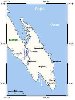
Maramasike Passage
Encyclopedia
Strait
A strait or straits is a narrow, typically navigable channel of water that connects two larger, navigable bodies of water. It most commonly refers to a channel of water that lies between two land masses, but it may also refer to a navigable channel through a body of water that is otherwise not...
which separates the two islands of Malaita Province
Malaita Province
Malaita Province is one of the largest provinces of the Solomon Islands. It is named for its largest island, Malaita . Other islands include South Malaita Island , Sikaiana Island, and Ontong Java Atoll. The provincial capital and largest urban center is Auki, located on Big Malaita...
in the Solomon Islands
Solomon Islands
Solomon Islands is a sovereign state in Oceania, east of Papua New Guinea, consisting of nearly one thousand islands. It covers a land mass of . The capital, Honiara, is located on the island of Guadalcanal...
, the larger Malaita
Malaita
Malaita is the largest island of the Malaita Province in the Solomon Islands. A tropical and mountainous island, Malaita's pristine river systems and tropical forests have not been exploited. Malaita is the most populous island of the Solomon Islands, with 140,000 people or more than a third of the...
and the smaller South Malaita Island
South Malaita Island
South Malaita Island, also known as Small Malaita and Maramasike, is a large island at the southern tip of the larger island of Malaita in the eastern part of the Solomon Islands. It is called "small" to distinguish it from the much larger mainland. It is now part of Malaita Province...
, also known as Maramasike. A similar passage is found between the Florida Islands
Florida Islands
The Nggela Islands, also known as the Florida Islands, are a small island group in the Central Province of the Solomon Islands, a state in the southwest Pacific Ocean....
. The channel is the result of volcanic activity. The northern mouth leads to Raroi Su'u Lagoon, a sheltered bay.
The channel is 28 miles long and is navigable by small vessels. The northern mouth is much wider than the southern mouth, and is several miles wide with scattered barrier island
Shoal
Shoal, shoals or shoaling may mean:* Shoal, a sandbank or reef creating shallow water, especially where it forms a hazard to shipping* Shoal draught , of a boat with shallow draught which can pass over some shoals: see Draft...
s and mangrove
Mangrove
Mangroves are various kinds of trees up to medium height and shrubs that grow in saline coastal sediment habitats in the tropics and subtropics – mainly between latitudes N and S...
patches. It narrows at the southern end, and is much deeper and is surrounded by cliffs. In places, the passage is less than 400 m wide and only about 4 m deep.
The Saltwater Crocodile
Saltwater Crocodile
The saltwater crocodile, also known as estuarine or Indo-Pacific crocodile, is the largest of all living reptiles...
may inhabit the area, particularly the Taha River and Taramata Creek near the northern end of the passage.
There are several villages along the passage, particularly on the northern stretch.
A protected area including the passage, the 'Are'are Lagoon, southern Malaita and western South Malaita has been proposed.