
Mansfield Dam
Encyclopedia
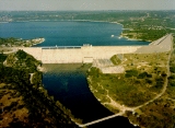
Mansfield Dam is a dam
located at 30.3923°N 97.9073°W (WGS 84
datum) across a canyon
at Marshall Ford on the Colorado River
, 13 miles (21 km) northwest of Austin, Texas
. Construction of the dam began in 1937 and was completed in 1941 as a joint project by the Lower Colorado River Authority
(LCRA) and the United States Bureau of Reclamation
. The company Brown and Root was awarded the contract to construct the dam. Brown and Root appointed James E. Walters, Sr (decades later Mr. Walters was selected to direct the construction of the Greater New Orleans Causeway
touted as the longest bridge in the world) to direct the project. Originally called Marshall Ford Dam, the name was changed in 1941 in honor of United States Representative
J.J. Mansfield
. The reservoir behind Mansfield Dam is named Lake Travis
. The dam is owned and operated by the LCRA.
Mansfield Dam is 278 feet (85 m) high, 7089 feet (2 km) long, and 213 feet (65 m) thick at the base. The concrete gravity dam with embankment
wings and saddle dikes was designed to control flood
ing; to store 1.4 km³ (369 billion US gallons) of water
; and to generate hydroelectric power (102 megawatts).
A two-lane highway, RM 620
, crossed the top of the dam, but traffic congestion brought on by the growth of the city of Austin and expanded popularity of recreation at Lake Travis forced the state to build a four-lane highway bridge on the downstream side of the dam. Traffic is no longer allowed on the road across the dam, except for service vehicles.
Dam
A dam is a barrier that impounds water or underground streams. Dams generally serve the primary purpose of retaining water, while other structures such as floodgates or levees are used to manage or prevent water flow into specific land regions. Hydropower and pumped-storage hydroelectricity are...
located at 30.3923°N 97.9073°W (WGS 84
World Geodetic System
The World Geodetic System is a standard for use in cartography, geodesy, and navigation. It comprises a standard coordinate frame for the Earth, a standard spheroidal reference surface for raw altitude data, and a gravitational equipotential surface that defines the nominal sea level.The latest...
datum) across a canyon
Canyon
A canyon or gorge is a deep ravine between cliffs often carved from the landscape by a river. Rivers have a natural tendency to reach a baseline elevation, which is the same elevation as the body of water it will eventually drain into. This forms a canyon. Most canyons were formed by a process of...
at Marshall Ford on the Colorado River
Colorado River (Texas)
The Colorado River is a river that runs through the U.S. state of Texas; it should not be confused with the much longer Colorado River which flows from Colorado into the Gulf of California....
, 13 miles (21 km) northwest of Austin, Texas
Austin, Texas
Austin is the capital city of the U.S. state of :Texas and the seat of Travis County. Located in Central Texas on the eastern edge of the American Southwest, it is the fourth-largest city in Texas and the 14th most populous city in the United States. It was the third-fastest-growing large city in...
. Construction of the dam began in 1937 and was completed in 1941 as a joint project by the Lower Colorado River Authority
Lower Colorado River Authority
The Lower Colorado River Authority or LCRA is a nonprofit public utility that was created in November 1934 by the Texas Legislature. LCRA's mission is to protect people, property and the environment by providing public services for more than one million people in Central and Southeast Texas...
(LCRA) and the United States Bureau of Reclamation
United States Bureau of Reclamation
The United States Bureau of Reclamation , and formerly the United States Reclamation Service , is an agency under the U.S...
. The company Brown and Root was awarded the contract to construct the dam. Brown and Root appointed James E. Walters, Sr (decades later Mr. Walters was selected to direct the construction of the Greater New Orleans Causeway
Lake Pontchartrain Causeway
The Lake Pontchartrain Causeway, or the Causeway, consists of two parallel bridges crossing Lake Pontchartrain in southern Louisiana, United States. The longer of the two bridges is long...
touted as the longest bridge in the world) to direct the project. Originally called Marshall Ford Dam, the name was changed in 1941 in honor of United States Representative
United States House of Representatives
The United States House of Representatives is one of the two Houses of the United States Congress, the bicameral legislature which also includes the Senate.The composition and powers of the House are established in Article One of the Constitution...
J.J. Mansfield
Joseph J. Mansfield
Joseph Jefferson Mansfield was a member of the United States House of Representatives from the U.S. state of Texas from 1917-1947.Mansfield was born on February 9, 1861. He was born in Wayne, West Virginia. However when he was born this was still part of state of Virginia...
. The reservoir behind Mansfield Dam is named Lake Travis
Lake Travis
Lake Travis is a reservoir on the Colorado River in central Texas in the United States. The reservoir was formed in 1942 by the construction of Mansfield Dam on the western edge of Austin, Texas by the Lower Colorado River Authority...
. The dam is owned and operated by the LCRA.
Mansfield Dam is 278 feet (85 m) high, 7089 feet (2 km) long, and 213 feet (65 m) thick at the base. The concrete gravity dam with embankment
Embankment dam
An embankment dam is a massive artificial water barrier. It is typically created by the emplacement and compaction of a complex semi-plastic mound of various compositions of soil, sand, clay and/or rock. It has a semi-permanent waterproof natural covering for its surface, and a dense, waterproof...
wings and saddle dikes was designed to control flood
Flood
A flood is an overflow of an expanse of water that submerges land. The EU Floods directive defines a flood as a temporary covering by water of land not normally covered by water...
ing; to store 1.4 km³ (369 billion US gallons) of water
Water
Water is a chemical substance with the chemical formula H2O. A water molecule contains one oxygen and two hydrogen atoms connected by covalent bonds. Water is a liquid at ambient conditions, but it often co-exists on Earth with its solid state, ice, and gaseous state . Water also exists in a...
; and to generate hydroelectric power (102 megawatts).
A two-lane highway, RM 620
Ranch to Market Road 620
Ranch to Market Road 620, Ranch Road 620, or RM 620 is a Ranch to Market Road in the U.S. state of Texas maintained by the Texas Department of Transportation . The road begins at in Bee Cave in Travis County west of Austin passing along southeastern Lake Travis, western Austin, and several...
, crossed the top of the dam, but traffic congestion brought on by the growth of the city of Austin and expanded popularity of recreation at Lake Travis forced the state to build a four-lane highway bridge on the downstream side of the dam. Traffic is no longer allowed on the road across the dam, except for service vehicles.