
Manitoba Highway 12
Encyclopedia
Provincial Trunk Highway 12 (PTH 12) is a provincial highway in the Canadian
province of Manitoba
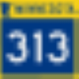
. It runs from the U.S. border (where it meets with Minnesota State Highway 313
) to a dead end in Grand Beach. PTH 12 forms the Manitoba section of MOM's Way
, a route from Thunder Bay to Winnipeg.
Canada
Canada is a North American country consisting of ten provinces and three territories. Located in the northern part of the continent, it extends from the Atlantic Ocean in the east to the Pacific Ocean in the west, and northward into the Arctic Ocean...
province of Manitoba
Manitoba
Manitoba is a Canadian prairie province with an area of . The province has over 110,000 lakes and has a largely continental climate because of its flat topography. Agriculture, mostly concentrated in the fertile southern and western parts of the province, is vital to the province's economy; other...
. It runs from the U.S. border (where it meets with Minnesota State Highway 313
Minnesota State Highway 313
Minnesota State Highway 313 is a highway in northwest Minnesota, which runs from its intersection with State Highway 11 in Warroad and continues north to its northern terminus at the U.S.-Canadian border; where the route becomes Manitoba Highway 12 upon crossing the border, near the communities of...
) to a dead end in Grand Beach. PTH 12 forms the Manitoba section of MOM's Way
Mom's Way
MOM's Way is the name for a series of highways in the Canadian provinces of Ontario and Manitoba, and the U.S. state of Minnesota. The name "MOM" is an acronym for Manitoba, Ontario, and Minnesota, the two provinces and one state traversed by this multi-highway route.The roads included along the...
, a route from Thunder Bay to Winnipeg.
Travel Route
This is the travel route for Provincial Trunk Highway 12 (PTH 12) from south to north.| km | Municipality | Location | Interescting highway | Notes |
|---|---|---|---|---|
| 0 | Piney R.M. | US-Canada Border | PTH 12 begins highway travels west for the first 48 kilometres |
|
| 6 | Middlebro | |||
| 21 | ||||
| 31 | – Roseau Roseau, Minnesota As of the census of 2000, there were 2,756 people, 1,157 households, and 713 families residing in the city. The population density was 1,153.6 people per square mile . There were 1,229 housing units at an average density of 514.4 per square mile... |
|||
| 48 | , Roseau Roseau, Minnesota As of the census of 2000, there were 2,756 people, 1,157 households, and 713 families residing in the city. The population density was 1,153.6 people per square mile . There were 1,229 housing units at an average density of 514.4 per square mile... , Red Lake Red Lake, Minnesota There is also a Red Lake County in Minnesota.Red Lake is a census-designated place within the Lower Red Lake unorganized territory located in Beltrami County, Minnesota, United States. As of the 2000 census, Red Lake had a total population of 1,436... , Bemidji Bemidji, Minnesota Bemidji is a city in Beltrami County, Minnesota, United States. Its population was at 13,431 at the 2010 census. It is the county seat of Beltrami County. Bemidji is the most major city in North Central Minnesota and the largest commercial center between Grand Forks, North Dakota and Duluth,... |
PTH 12 turns northwest | ||
| 62 | ||||
| 84 | Stuartburn R.M. Stuartburn, Manitoba (rural municipality) Stuartburn is a rural municipality located in the Eastman Region of Manitoba, Canada. It had a population of 1,629 according to the Canada 2006 Census. It is home to the Ukrainian-Canadian village of Stuartburn... |
PTH 12 turns west | ||
| 94 | La Broquerie R.M. La Broquerie, Manitoba (rural municipality) La Broquerie is a rural municipality in the province of Manitoba in Western Canada. It is located in the southeastern part of the province, just southeast of the city of Steinbach. The 2006 Census reported a population of 3,659 persons, a 26.4% increase from the 2,894 reported in the 2001 Census... |
Zhoda Zhoda, Manitoba Zhoda is a community in Manitoba, Canada, approximately 20 kilometres north of the town of Vita. Zhoda is situated on the intersection of Highway 302 and Highway 12, in the Rural Municipality of La Broquerie.... |
PR 302 to Vita formerly PR 208 south | |
| 102 | ||||
| 113 | Hanover R.M. Hanover, Manitoba Hanover is a rural municipality in southeastern Manitoba, Canada. It is located southeast of Winnipeg. It is located in Division No. 2. The city of Steinbach is located in the northeastern part of the municipality, although it is self-governing and is not technically part of the Hanover... |
PTH 12 turns north 3 km before junction | ||
| 121 | ||||
| 128 | Steinbach Steinbach, Manitoba Steinbach is a city of approx. 13,500 people in the southeast corner of the province of Manitoba, Canada, a short distance from the capital Winnipeg. Steinbach is the largest community in the Eastman region of Manitoba. The city is located in the R.M. of Hanover and bordered to the east by the R.M... |
|||
| 133 | begin PR 311 west concurrence | |||
| 137 | Blumenort Blumenort, Manitoba Blumenort is a village of about 1,000 people, in the Canadian province of Manitoba. It is located in the Rural Municipality of Hanover, just north of the city of Steinbach. It was founded in 1874 by Mennonite farmers... |
end PR 311 west concurrence | ||
| 144 | Ste. Anne R.M. Ste. Anne, Manitoba (rural municipality) Ste. Anne is a rural municipality lying southeast of Winnipeg, Manitoba, Canada. It is part of the Eastman Region and the Manitoba Census Division No. 2. Its 2001 census population was 4,427. The separately administered town of Ste. Anne lies within the borders of the municipality, in its... |
begin PR 210 east concurrence | ||
| 145 | Ste. Anne | end PR 210 east concurrence | ||
| 147 | , Kenora Kenora, Ontario Kenora , originally named Rat Portage, is a small city situated on the Lake of the Woods in Northwestern Ontario, Canada, close to the Manitoba boundary, and about east of Winnipeg... |
|||
| 152 | Taché R.M. Taché, Manitoba Incorporated in 1880, Taché is a rural municipality in Manitoba, Canada. Named after the Bishop Taché , it is located to the south-east of Winnipeg, stretching from the Red River Floodway in the west to the beginning of the Canadian Shield in the east... |
|||
| 166 | Springfield R.M. | Anola Anola, Manitoba Anola, Manitoba, Canada, is a small town located 24 km east of Winnipeg and 40 km north of Steinbach in the Rural Municipality of Springfield... |
||
| 176 | Brokenhead R.M. Brokenhead, Manitoba Brokenhead is a rural municipality in the province of Manitoba in Western Canada. The separately administered town of Beausejour lies within the borders of the municipality, south of its centre.- Notable natives or residents :... |
|||
| 185 | ||||
| 187 | PTH 12 turns east begin PTH 44 east concurrence |
|||
| 197 | Beausejour Beausejour, Manitoba Beausejour is a town of 2,772 inhabitants in the Canadian province of Manitoba located in the Rural Municipality of Brokenhead. It is located 46 kilometres northeast of Winnipeg just west of the Canadian Shield and Whiteshell Provincial Park... |
PTH 12 turns north end PTH 44 east concurrence |
||
| 205 | , Milner Ridge | |||
| 218 | ||||
| 232 | St. Clements R.M. St. Clements, Manitoba St. Clements is a rural municipality in Manitoba, Canada. It is located to the north-east of Winnipeg, stretching from East St. Paul and Birds Hill Provincial Park in the south to Lake Winnipeg and Grand Beach Provincial Park to the north. The Red River demarcates the western boundary of the... |
PTH 12 turns northwest | ||
| 237 | Alexander R.M. Alexander, Manitoba Alexander is a rural municipality in Manitoba, Canada. According to the Canada 2006 Census, this rural municipality, for the first time, ranked above 1,000 in terms of population. The town of Powerview-Pine Falls lies adjacent to the municipality, as does the Fort Alexander First Nation Indian... |
PTH 12 turns north begin PTH 59 north concurrence |
||
| 239 | – Beaconia |
|||
| 247 | PTH 12 turns northwest end PTH 59 north concurrence |
|||
| 251 | – Beaconia | |||
| 254 | Grand Marais | |||
| 256 | Grand Beach Grand Beach, Manitoba Grand Beach is a freshwater beach on the eastern shore of Lake Winnipeg in Manitoba, Canada. It is located on the northern edge of the town of Grand Marais.-History:... |
PTH 12 ends | ||