

Manhattan Waterfront Greenway
Encyclopedia


Foreshoreway
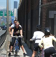
A foreshoreway is a type of greenway that provides a public right of way along the edge of a waterbody.Foreshoreways are usually focused on sustainable behaviours and hence are a common facility for sustainable transport. The terminology was derived to assist to avoid the perception of a pavement...
for walking
Walking
Walking is one of the main gaits of locomotion among legged animals, and is typically slower than running and other gaits. Walking is defined by an 'inverted pendulum' gait in which the body vaults over the stiff limb or limbs with each step...
or cycling
Cycling
Cycling, also called bicycling or biking, is the use of bicycles for transport, recreation, or for sport. Persons engaged in cycling are cyclists or bicyclists...
, 32 miles (51.5 km) long, around the island of Manhattan
Manhattan
Manhattan is the oldest and the most densely populated of the five boroughs of New York City. Located primarily on the island of Manhattan at the mouth of the Hudson River, the boundaries of the borough are identical to those of New York County, an original county of the state of New York...
. The largest portions are operated by the New York City Department of Parks. It is separated from motor traffic, and many sections also separate pedestrian
Pedestrian
A pedestrian is a person traveling on foot, whether walking or running. In some communities, those traveling using roller skates or skateboards are also considered to be pedestrians. In modern times, the term mostly refers to someone walking on a road or footpath, but this was not the case...
s from cyclists. There are three principal parts:
Hudson River Greenway
HRGW is the longest, running along the West Side, from Dyckman Street in the north to Battery ParkBattery Park
Battery Park is a 25-acre public park located at the Battery, the southern tip of Manhattan Island in New York City, facing New York Harbor. The Battery is named for artillery batteries that were positioned there in the city's early years in order to protect the settlement behind them...
in the south, mostly through Riverside Park
Riverside Park (Manhattan)
Riverside Park is a scenic waterfront public park on the Upper West Side of the borough of Manhattan in New York City, operated and maintained by the New York City Department of Parks and Recreation. The park consists of a narrow four-mile strip of land between the Hudson River and the gently...
and Hudson River Park
Hudson River Park
Hudson River Park is a waterside park on the Hudson River that extends from 59th Street south to Battery Park in the New York City borough of Manhattan. Bicycle and pedestrian paths, including the Manhattan Waterfront Greenway, span the park north to south, opening up the waterfront for...
. A gap in West Harlem
Harlem
Harlem is a neighborhood in the New York City borough of Manhattan, which since the 1920s has been a major African-American residential, cultural and business center. Originally a Dutch village, formally organized in 1658, it is named after the city of Haarlem in the Netherlands...
was filled in early October 2008 with the opening of the Harlem Piers bike lane. A roughly 10-block detour in the west 80s, where a walkway had crumbled into the river in the late 20th century, was eliminated on May 20, 2010, when the rebuilt section of greenway was opened.
The Hudson River Greenway is the most heavily used bikeway
Bikeway
A Bikeway is a route, way or path which in some manner is specifically designed and /or designated for bicycle travel.-See also:*Bicycle boulevard*Bicycle trail*Bicycle transportation engineering*Foreshoreway*Greenway* List of cycleways...
in the United States
United States
The United States of America is a federal constitutional republic comprising fifty states and a federal district...
. Most is near Hudson River
Hudson River
The Hudson is a river that flows from north to south through eastern New York. The highest official source is at Lake Tear of the Clouds, on the slopes of Mount Marcy in the Adirondack Mountains. The river itself officially begins in Henderson Lake in Newcomb, New York...
water level, except the portion north of George Washington Bridge
George Washington Bridge
The George Washington Bridge is a suspension bridge spanning the Hudson River, connecting the Washington Heights neighborhood in the borough of Manhattan in New York City to Fort Lee, Bergen County, New Jersey. Interstate 95 and U.S. Route 1/9 cross the river via the bridge. U.S...
where it climbs steeply, to approximately 160 feet (50 m) and includes Inspiration Point.
Near the downtown end, ongoing renovation work on the South Ferry subway station
South Ferry (New York City Subway)
The South Ferry loops are a pair of New York City Subway underground stations in South Ferry, Manhattan that have been disused since March 2009...
is to result in a connection through Battery Park to the East River Greenway. Travelers to Brooklyn
Brooklyn
Brooklyn is the most populous of New York City's five boroughs, with nearly 2.6 million residents, and the second-largest in area. Since 1896, Brooklyn has had the same boundaries as Kings County, which is now the most populous county in New York State and the second-most densely populated...
use a bike lane in Warren Street and a one-way bike path (opened in September 2008) through the north end of City Hall Park to connect to the Brooklyn Bridge
Brooklyn Bridge
The Brooklyn Bridge is one of the oldest suspension bridges in the United States. Completed in 1883, it connects the New York City boroughs of Manhattan and Brooklyn by spanning the East River...
. Those arriving from Brooklyn use lanes in Park Row
Park Row (Manhattan)
Park Row is a street located in the Financial District of the New York City borough of Manhattan. It was previously called Chatham Street and during the late 19th century it was nicknamed Newspaper Row, as most of New York City's newspapers located on the street to be close to the action at New...
and Murray Street to reach the Greenway.
Footpaths continue a mile north from Dyckman Street into Inwood Hill Park
Inwood Hill Park
Inwood Hill Park is a city-owned and maintained public park in Inwood, Upper Manhattan, New York City, operated by the New York City Department of Parks and Recreation. It stretches along the Hudson River from Dyckman Street to the northern tip of the island. Inwood Hill Park's densely folded,...
alongside the western ball fields, at which point the path crosses the Amtrak rail tracks using a bridge with steps. This continues northeast into the park as part of the park trail system and connects north to bikeways in Spuyten Duyvil in the Bronx via the Henry Hudson Bridge
Henry Hudson Bridge
The Henry Hudson Bridge is a steel arch toll bridge in New York City across the Spuyten Duyvil Creek. It connects the Spuyten Duyvil section of The Bronx with the northern end of Manhattan to the south. On the Manhattan side, it touches Inwood Hill Park. The bridge was designed by David B. Steinman...
, and east to the bike lane on 218th St leading to the Broadway Bridge. However, Inwood Hill Park currently bans bicycles on all paths so the connections are not technically recognized nor officially encouraged at this time.
East River Greenway
This runs along the East Side from The BatteryBattery Park
Battery Park is a 25-acre public park located at the Battery, the southern tip of Manhattan Island in New York City, facing New York Harbor. The Battery is named for artillery batteries that were positioned there in the city's early years in order to protect the settlement behind them...
and past South Street Seaport
South Street Seaport
The South Street Seaport is a historic area in the New York City borough of Manhattan, located where Fulton Street meets the East River, and adjacent to the Financial District. The Seaport is a designated historic district, distinct from the neighboring Financial District...
to East Harlem with a 1.3 mile (2 km) gap from 34th
34th Street (Manhattan)
34th Street is a major cross-town street in the New York City borough of Manhattan, connecting the Lincoln Tunnel and Queens-Midtown Tunnel. Like many of New York City's major crosstown streets, it has its own bus routes and four subway stops serving the trains at Eighth Avenue, the trains at...
to 60th streets in Midtown
Midtown Manhattan
Midtown Manhattan, or simply Midtown, is an area of Manhattan, New York City home to world-famous commercial zones such as Rockefeller Center, Broadway, and Times Square...
where pedestrians use busy First
First Avenue (Manhattan)
First Avenue is a north-south thoroughfare on the East Side of the New York City borough of Manhattan, running from Houston Street northbound for over 125 blocks before terminating at the Willis Avenue Bridge into The Bronx at the Harlem River near East 127th Street. South of Houston Street, the...
and Second
Second Avenue (Manhattan)
Second Avenue is an avenue on the East Side of the New York City borough of Manhattan extending from Houston Street at its south end to the Harlem River Drive at 128th Street at its north end. A one-way street, vehicular traffic runs only downtown. A bicycle lane in the left hand portion from 55th...
Avenues to get around United Nations Headquarters
United Nations headquarters
The headquarters of the United Nations is a complex in New York City. The complex has served as the official headquarters of the United Nations since its completion in 1952. It is located in the Turtle Bay neighborhood of Manhattan, on spacious grounds overlooking the East River...
between the Upper East Side
Upper East Side
The Upper East Side is a neighborhood in the borough of Manhattan in New York City, between Central Park and the East River. The Upper East Side lies within an area bounded by 59th Street to 96th Street, and the East River to Fifth Avenue-Central Park...
and Kips Bay
Kips Bay
Kips Bay is a neighborhood in the New York City borough of Manhattan. Because there are no official boundaries for New York City neighborhoods, the limits of Kip's Bay are somewhat vague, but it is often considered to be the area between East 23rd Street and East 34th Street extending from...
portions of the Greenway. Cyclists going further north who do not wish to carry their bike up a long flight of stairs skip the 60th Street access and continue in the on street bike lane another mile (1.7 km) to 83rd Street. Some places are narrow due to sinkholes being blocked off by protective fencing, and one part squeezes between the highway and the dock of Con Edison's East River Station, requiring slower speeds. Other parts are shared space with motor access to Waterside Plaza
Waterside Plaza
Waterside Plaza, formerly a Mitchell-Lama Housing Program-funded rental apartment complex, is located on the East River in the Kips Bay section of Manhattan, New York City.- Overview :...
or a filling station. Approximately a mile near the southwest end is in the shadow of the elevated FDR Drive.
In the summer of 2008 the East River Greenway along with the Brooklyn Promenade provided viewing locations to see the New York City Waterfalls
New York City Waterfalls
New York City Waterfalls is a public art project by artist Olafur Eliasson, in collaboration with the Public Art Fund, consisting of four man-made waterfalls placed around New York City along the East River. At $15.5 million, it is the most expensive public arts project since Christo and...
.
In October 2011, the city and state reached an agreement to use the western portion of Robert Moses Playground
Robert Moses Playground
Robert Moses Playground is a playground and park in the New York City borough of Manhattan. It is located in the Murray Hill neighborhood on First Avenue between 41st and 42nd streets, immediately south of the United Nations Headquarters...
for an expansion of the United Nations campus. In exchange, the United Nations Development Corporation
United Nations Development Corporation
The United Nations Development Corporation is a public benefit corporation in New York State that helps the United Nations with its real estate and development needs....
would pay $73 million to fund the development of the gap in the Greenway between 38th and 60th streets.
Harlem River Greenway
Partially following the route of the old Harlem River Speedway, the Harlem River Greenway is the shortest portion of the Manhattan Waterfront Greenway and is completely uninterrupted, running north from 155th Street155th Street (Manhattan)
155th Street is a major crosstown street in the Harlem neighborhood, in the New York City borough of Manhattan. It is the northernmost of the 155 crosstown streets mapped out in the Commissioner's Plan of 1811 that established the numbered street grid in Manhattan.155th Street starts on the West...
, at the north end of Central Harlem, to Dyckman Street in northern Manhattan, between the Harlem River
Harlem River
The Harlem River is a navigable tidal strait in New York City, USA that flows 8 miles between the Hudson River and the East River, separating the boroughs of Manhattan and the Bronx...
and Harlem River Drive
Harlem River Drive
The Harlem River Drive is a north–south parkway in the New York City borough of Manhattan. It runs along the west bank of the Harlem River from the Triborough Bridge in East Harlem to 10th Avenue in Inwood, where the parkway continues north as Dyckman Street. The portion of the Harlem River Drive...
. Users of the East River Greenway must use ordinary streets through East Harlem to reach this portion. A bike lane in Dyckman Street through Inwood
Inwood, Manhattan
Inwood is the northernmost neighborhood on Manhattan Island in the New York City borough of Manhattan.-Geography:Inwood is physically bounded by the Harlem River to the north and east, and the Hudson River to the west. It extends southward to Fort Tryon Park and alternatively Dyckman Street or...
connects to Inwood Hill Park
Inwood Hill Park
Inwood Hill Park is a city-owned and maintained public park in Inwood, Upper Manhattan, New York City, operated by the New York City Department of Parks and Recreation. It stretches along the Hudson River from Dyckman Street to the northern tip of the island. Inwood Hill Park's densely folded,...
and the Hudson River Greenway via a shallow flight of stairs which is to be replaced by a bike ramp.