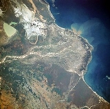
Mangoky River
Encyclopedia

Madagascar
The Republic of Madagascar is an island country located in the Indian Ocean off the southeastern coast of Africa...
. It rises in the Central Highlands
Central Highlands (Madagascar)
The Central Highlands, Central High Plateau, or Hauts-Plateaux are a mountainous biogeographical region in central Madagascar. They include the contiguous part of the island's interior above 800 m altitude...
of Madagascar
Madagascar
The Republic of Madagascar is an island country located in the Indian Ocean off the southeastern coast of Africa...
just east of the city of Fianarantsoa
Fianarantsoa
Fianarantsoa is a city in south central Madagascar.Fianarantsoa is the capital of Haute Matsiatra Region. It was built in the early 19th century by the Merina as the administrative capital for the newly conquered Betsileo kingdoms....
. The river flows generally in a westerly direction out of the highlands, crosses the southern extension of the Bemaraha Plateau, reaches the coastal plain and its delta, and enters the Mozambique Channel
Mozambique Channel
The Mozambique Channel is a portion of the Indian Ocean located between the island nation of Madagascar and southeast Africa, primarily the country of Mozambique. It was a World War II clashpoint during the Battle of Madagascar...
north of the city of Morombe
Morombe
Morombe is a coastal city in Atsimo-Andrefana Region, Madagascar. It is located at around and can be reached by pirogue from Morondava.- Literatur :...
at 21.3166667°S 43.5333333°E.
Most of Madagascar has undergone serious deforestation
Deforestation
Deforestation is the removal of a forest or stand of trees where the land is thereafter converted to a nonforest use. Examples of deforestation include conversion of forestland to farms, ranches, or urban use....
during the last 40 years, chiefly from slash-and-burn practises by indigenous peoples. This loss of forest has led to extreme soil erosion
Erosion
Erosion is when materials are removed from the surface and changed into something else. It only works by hydraulic actions and transport of solids in the natural environment, and leads to the deposition of these materials elsewhere...
in the Mangoky River basin, as evidenced by the many sandbars located within the river channel. Silt-laden, greenish-tan Lake Ihotry
Lake Ihotry
Lake Ihotry is a closed saline lake in semi-arid southwestern part of Madagascar. Its area varies seasonally, from 96 km² to 112 km².-References:* *...
is clearly discernible south of the river. Between the lake and the coast is a rather large, whitish area of sand interspersed with silt-laden ponds. The southern portion of the delta is dominated by successive barrier island and spit formation. In contrast, the northern, protected portion of the delta is dominated by tidal passes and mangrove
Mangrove
Mangroves are various kinds of trees up to medium height and shrubs that grow in saline coastal sediment habitats in the tropics and subtropics – mainly between latitudes N and S...
swamps.

