
Manaure, La Guajira
Encyclopedia
Manaure or Salinas de Manaure is a town and municipality located in the Colombia
n Department
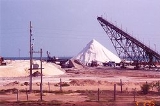
of La Guajira. Manaure's main economic activity is the exploitation of the vast amounts of salt in the area.
, in the Colombian Caribbean region, bordering to the north with the Caribbean Sea
to the east with the municipality of Uribia
; to the south with the municipality of Maicao and to the west with the municipality of Riohacha
.
The municipality of Manaure is within the Guajira-Barranquilla xeric scrub
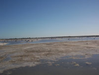
with water streams determined by precipitations during the rainy seasons. The municipality seat of Manaure is crossed by the Limón Creek which flows into the Caribbean sea. The coastline has high concentration of salt, rocks and clay over predominantly flat plains, slightly undulated in some areas.
 Chronicles from the Spanish explorer first detailed some indigenous in the area called Coanaos which traveled between the Cabo de la Vela
and the region of Valledupar
to exchange salt for gold. During the 19th century salt in the region was exploited at Honda Bay and Quebrada Bay on coasts of what is part of the municipality of Manaure which naturally formed lagoons. In 1777 the Spanish government ordered the administration of the Salinas.
In 1824 the government declared the Salinas or salt mines as national patrimony of the nation establishing a regulatory price control. In 1932 the bank of the Republic
was given authority over the administration and exploitation of salt mines in Zipaquirá
, Nemocón
and Sesquilé
.
Industrial exploitation and processing of salt in Manaure began in the 1920s when the government gave concessions to individual investors for the exploitation of the salt mine and until the 1940s the mode of collection went from artisan to industrial, when the Bank of the Republic took over the Manaure salt mines. By 1948 salt production in Manaure was between 20,000 and
30,000 tons a year. In 1970 the concession of Manaure salt mines was transferred to the IFI-Concesión Salinas which intensified the production to one million tons a year.
The Wayuu
began to claim the area as their ancestral land and historical owners of Manaure. In 1991 the government recognized the claim by the Wayuu and agreed to reorganize production and work conditions under a mixed economy, in which the indigenous would have 25% of the stocks in the company. The accords were not met and the Wayuus sued the government in 1994. The court ordered the creation of Sociedad Salinas de Manaure, SAMA based on the original agreement and linked to the then Ministry of Development. The Wayuu would have 25%, but once again the agreements were not met due to legal problems. In 2002 Law 773 of the same year reestablished the creation of the SAMA, distributing earnings among the Ministry of Development (51%) the indigenous Association "Sumain Ichi" (25%) and the municipality of Manaure (25%).
Colombia
Colombia, officially the Republic of Colombia , is a unitary constitutional republic comprising thirty-two departments. The country is located in northwestern South America, bordered to the east by Venezuela and Brazil; to the south by Ecuador and Peru; to the north by the Caribbean Sea; to the...
n Department
Departments of Colombia
Colombia is an unitary republic formed by thirty-two departments and a Capital District . Each department has a Governor and a Department Assembly , elected by popular vote for a four-year period. The governor cannot be re-elected in consecutive periods...
of La Guajira. Manaure's main economic activity is the exploitation of the vast amounts of salt in the area.
Geography
The municipality of Manaure is located in northern most part of South America, on the arid plains of the Guajira PeninsulaGuajira Peninsula
Guajira Peninsula , is a peninsula in northern Colombia and northwestern Venezuela in the Caribbean Sea...
, in the Colombian Caribbean region, bordering to the north with the Caribbean Sea
Caribbean Sea
The Caribbean Sea is a sea of the Atlantic Ocean located in the tropics of the Western hemisphere. It is bounded by Mexico and Central America to the west and southwest, to the north by the Greater Antilles, and to the east by the Lesser Antilles....
to the east with the municipality of Uribia
Uribia, La Guajira
Uribia is town and municipality of the Colombian Department of La Guajira. It is the youngest municipality of this Department since the year 2000. Northern Zone of the Cerrejón coal mines are located in this municipality. The municipality also contains the Serranía de Macuira mountain range which...
; to the south with the municipality of Maicao and to the west with the municipality of Riohacha
Riohacha
Riohacha, Rio Hacha or Rio de la Hacha , is a city in the Riohacha Municipality in the northern Caribbean Region of Colombia by the mouth of the Ranchería River and the Caribbean sea, capital city of the La Guajira Department. Founded by conquistador Nikolaus Federmann in 1535, Riohacha was named...
.
The municipality of Manaure is within the Guajira-Barranquilla xeric scrub
Guajira-Barranquilla xeric scrub
The Guajira-Barranquilla xeric scrub is a xeric shrubland ecoregion in Colombia, covering an estimated area of 150.000 km2.-Setting:The ecoregion occupies the Guajira Peninsula, the valley of Rancheria river and Guajira Department, covering parts of the northeastern coast of Venezuela...
with water streams determined by precipitations during the rainy seasons. The municipality seat of Manaure is crossed by the Limón Creek which flows into the Caribbean sea. The coastline has high concentration of salt, rocks and clay over predominantly flat plains, slightly undulated in some areas.
Climate
Climate in the municipality of Manaure is hot and dry throughout the year, averaging between 28°C and 38°C throughout the year with constant winds from the northeastern trade winds, evaporation of humidity is high. The area has two rainy seasons averaging 150 mm³ from May to June and from October to November) and two dry seasons in between these months.History
Cabo de la Vela
Cabo de la Vela is a headland in the Guajira Peninsula in Colombia with an adjacent small fishing village. It is a popular ecotourism destination of the Caribbean Region of Colombia-History:...
and the region of Valledupar
Valledupar
Valledupar is a city and municipality in northeastern Colombia. It is the capital of Cesar Department and was founded in 1550 by the Spanish conquistador Hernando de Santana. Its name, Valle de Upar , was established in honor of the Amerindian cacique who ruled the valley; Cacique Upar...
to exchange salt for gold. During the 19th century salt in the region was exploited at Honda Bay and Quebrada Bay on coasts of what is part of the municipality of Manaure which naturally formed lagoons. In 1777 the Spanish government ordered the administration of the Salinas.
In 1824 the government declared the Salinas or salt mines as national patrimony of the nation establishing a regulatory price control. In 1932 the bank of the Republic
Bank of the Republic (Colombia)
The Bank of the Republic is the state-run central bank of the Republic of Colombia. Its main functions are detailed by the Congress according to the . One of them is the issuance of the Colombian currency, the peso.-History:...
was given authority over the administration and exploitation of salt mines in Zipaquirá
Zipaquirá
Zipaquirá is a municipality and city of Colombia in the department of Cundinamarca. Its neighboring municipalities are Tausa and Cogua to the north; Nemocón, Gachancipá and Sopó to the east; Cajicá and Tabio to the south; and Subachoque and Pacho to the west. Its seat of municipal government is 49...
, Nemocón
Nemocón
Nemocón is a municipality and town of Colombia in the department of Cundinamarca.- History :Nemcón means "The cry of the warrior" in the Chibcha language. The city was founded by Spanish settlers in 1537.- Geography and description :...
and Sesquilé
Sesquilé
Sesquilé is a town and municipality in Almeidas Province, in the department of Cundinamarca, Colombia. Sesquile in Muisca language means hot water....
.
Industrial exploitation and processing of salt in Manaure began in the 1920s when the government gave concessions to individual investors for the exploitation of the salt mine and until the 1940s the mode of collection went from artisan to industrial, when the Bank of the Republic took over the Manaure salt mines. By 1948 salt production in Manaure was between 20,000 and
30,000 tons a year. In 1970 the concession of Manaure salt mines was transferred to the IFI-Concesión Salinas which intensified the production to one million tons a year.
The Wayuu
Wayuu
Wayuu is an Amerindian ethnic group of the La Guajira Peninsula in northern Colombia and northwest Venezuela. They are part of the Maipurean language family.- Geography :...
began to claim the area as their ancestral land and historical owners of Manaure. In 1991 the government recognized the claim by the Wayuu and agreed to reorganize production and work conditions under a mixed economy, in which the indigenous would have 25% of the stocks in the company. The accords were not met and the Wayuus sued the government in 1994. The court ordered the creation of Sociedad Salinas de Manaure, SAMA based on the original agreement and linked to the then Ministry of Development. The Wayuu would have 25%, but once again the agreements were not met due to legal problems. In 2002 Law 773 of the same year reestablished the creation of the SAMA, distributing earnings among the Ministry of Development (51%) the indigenous Association "Sumain Ichi" (25%) and the municipality of Manaure (25%).