
Manassa, Colorado
Encyclopedia
The Town of Manassa is a Statutory Town that is the most populous town in Conejos County
, Colorado
, United States
. With a population of 1,042 at the 2000 census, Manassa is the largest community in Conejos County.
This small town, surrounded by farms and ranches, is exactly one square mile in size, with a small amount of residential development on its outskirts. A mostly agricultural community, there are few business establishments in the town. A small-town feel abounds with no traffic control signals or stop lights.
The U.S. Post Office zip code for Manassa is 81141, and the area code is (719).
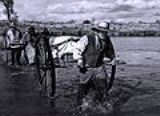
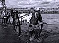 Today, approximately half of Manassa's residents are of Spanish and Mexican heritage. Migration patterns reflect people from northern New Mexico settled this area in the mid 19th century. Many are the descendants of colonists from the Spanish colonial period beginning in 1598 with Juan de Oñate colonization of New Mexico. Most of the other citizens of Manassa are the descendants of the Mormon pioneers who founded Manassa in 1879, and named the town after a son of the Israelite, Joseph.
Manassa was located a short distance from two ranches purchased by the Mormons from Hispanos on the south side of the Conejos River, across from Los Cerritos.
The selection of the land for the colony was made on the assurance that the railroad would soon be built nearby. However, one year later the railroad bypassed the colony, and instead passed through Romeo, Colorado, just three miles (5 km) to the west.
This legendary area is not far from the headwaters of the Rio Grande
, a short distance from the Continental Divide
and the Great Sand Dunes National Park and Preserve
and is surrounded by the world famous Rocky Mountains
.
Manassa's elevation is 7683 feet (2,341.8 m) above sea level, however, the land within Manassa city limits is entirely flat, with rolling hills nearby. Foothills and mountains (taller than 14,000 feet) are farther in each direction, including the Sangre de Cristo mountain range to the east and the San Juan mountain range to the west.
According to the United States Census Bureau
, the town has a total area of 0.9 square miles (2.3 km²), all of it land.
Manassa experiences a semi-arid climate (Köppen
BSk) with cold, dry winters and warm, somewhat wetter summers.
of 2000, there were 1,042 people, 362 households, and 280 families residing in the town. The population density
was 1,110.9 people per square mile (428.0/km²). There were 398 housing units at an average density of 424.3 per square mile (163.5/km²). The racial makeup of the town was 81.00% White, 0.48% African American, 1.63% Native American, 0.10% Asian, 0.19% Pacific Islander, 13.24% from other races
, and 3.36% from two or more races. Hispanic or Latino of any race were 48.75% of the population.
There were 362 households out of which 41.2% had children under the age of 18 living with them, 59.1% were married couples
living together, 13.5% had a female householder with no husband present, and 22.4% were non-families. 20.7% of all households were made up of individuals and 9.1% had someone living alone who was 65 years of age or older. The average household size was 2.88 and the average family size was 3.33.
In the town the population was spread out with 33.7% under the age of 18, 9.4% from 18 to 24, 22.9% from 25 to 44, 20.3% from 45 to 64, and 13.6% who were 65 years of age or older. The median age was 31 years. For every 100 females there were 95.9 males. For every 100 females age 18 and over, there were 97.4 males.
The median income for a household in the town was $23,092, and the median income for a family was $26,827. Males had a median income of $23,295 versus $16,029 for females. The per capita income
for the town was $12,576. About 23.2% of families and 28.6% of the population were below the poverty line, including 40.8% of those under age 18 and 19.4% of those age 65 or over.
s, are fashioned in a grid system. The town fits perfectly in a township and comprises one square mile made up of eight blocks by eight blocks for a total of 64 city blocks. From east to west, the streets are numbered First through Ninth. From south to north, the streets are named South, Jack, Morgan, Smith, Main (aka State Highway 142), Berthelson, Peterson, Dotson, and North.
Manassa's mile-long Main Street is also known as State Highway 142, connecting Romeo (3 miles to the west) with the historic town of San Luis (Costilla County) to the east. The San Luis Hills are east of Manassa, on State Highway 142, between Manassa and the town of San Luis
.
24 miles (38.6 km) to the north. Alamosa, with a population of about 8,500, is the home of Adams State College
and is also the main trading center for the San Luis Valley
.
There are two churches in Manassa: St. Theresa of the Baby Jesus Roman Catholic Church
and a meetinghouse for The Church of Jesus Christ of Latter-day Saints. The oldest church in Colorado is located in nearby Conejos, Colorado
, about ten miles (16 km) southwest of Manassa and near the town of Antonito.
A carnival at Pioneer Days brings the Tilt-a-Whirl, bumper cars, a merry-go-round and other midway rides. Bandstand entertainment and vendor booths line Manassa’s city park on Main Street.
One of the oldest festivals in the state, the 131st annual celebration was held in 2010 and is an annual event. The weekend-long affair is held on the weekend closest to July 24, in honor of the arrival of Brigham Young and fellow members of the Church of Jesus Christ of Latter-day Saints in Utah's Great Salt Lake Valley on July 24, 1847 [see Pioneer Day (Utah)].
The Mormon pioneers, as they were commonly known, left their settlement in Nauvoo, Illinois
, and journeyed West seeking refuge from religious persecution.
Each year, attendance at Manassa's Pioneer Days is estimated at close to 10,000 per day, with people coming from many parts of the country to visit family and friends and to enjoy the festivities.
 Manassa turquoise
is mined east of Manassa, in south central Colorado. It is known for its blue-green to green color with a golden or brown, non-webbed matrix. The Manassa mine is still in production, and owned by the King family, thus the alternate name sometimes used for this turquoise. This stone is a favorite of many; the beautiful green color is very striking, excellent when used in gold.
This site, originally mined by Ancestral Pueblo peoples, was rediscovered in 1890 by gold prospector I.P. King, and his descendants still work the claim. King’s Manassa turquoise is best known for its brilliant greens and golden matrices, but blue and blue-green turquoise was found amid these deposits as well.
While some turquoise has been mined in the low hills east of Manassa, most of the jewelry industry in Manassa, and nearby, has utilized and polished the raw turquoise found in the copper and silver mines of Arizona and Nevada. Additionally, coral from the seas and other semiprecious cabachons and cut stones have been added to silver and gold jewelry.
Conejos County Official Website
Conejos County, Colorado
Conejos County is one of the 64 counties of the State of Colorado in the United States. The county population was 8,400 at U.S. Census 2000. The county seat is the unincorporated town of Conejos.-History:...
, Colorado
Colorado
Colorado is a U.S. state that encompasses much of the Rocky Mountains as well as the northeastern portion of the Colorado Plateau and the western edge of the Great Plains...
, United States
United States
The United States of America is a federal constitutional republic comprising fifty states and a federal district...
. With a population of 1,042 at the 2000 census, Manassa is the largest community in Conejos County.
This small town, surrounded by farms and ranches, is exactly one square mile in size, with a small amount of residential development on its outskirts. A mostly agricultural community, there are few business establishments in the town. A small-town feel abounds with no traffic control signals or stop lights.
The U.S. Post Office zip code for Manassa is 81141, and the area code is (719).
History
Manassa was located a short distance from two ranches purchased by the Mormons from Hispanos on the south side of the Conejos River, across from Los Cerritos.
The selection of the land for the colony was made on the assurance that the railroad would soon be built nearby. However, one year later the railroad bypassed the colony, and instead passed through Romeo, Colorado, just three miles (5 km) to the west.
Geography
Just directly north of the New Mexico state border, Manassa is located in the San Luis Valley in just about the southernmost central part of the State of Colorado at 37°10′29"N 105°56′11"W ( Latitude 37.174695 North, Longitude 105.936359 West).This legendary area is not far from the headwaters of the Rio Grande
Rio Grande
The Rio Grande is a river that flows from southwestern Colorado in the United States to the Gulf of Mexico. Along the way it forms part of the Mexico – United States border. Its length varies as its course changes...
, a short distance from the Continental Divide
Continental Divide
The Continental Divide of the Americas, or merely the Continental Gulf of Division or Great Divide, is the name given to the principal, and largely mountainous, hydrological divide of the Americas that separates the watersheds that drain into the Pacific Ocean from those river systems that drain...
and the Great Sand Dunes National Park and Preserve
Great Sand Dunes National Park and Preserve
-Other features:The park also contains alpine lakes and tundra, six peaks over 13,000 feet in elevation, ancient spruce and pine forests, large stands of aspen and cottonwood, grasslands, and wetlands — all habitat for diverse wildlife and plant species.One of the most unusual features of...
and is surrounded by the world famous Rocky Mountains
Rocky Mountains
The Rocky Mountains are a major mountain range in western North America. The Rocky Mountains stretch more than from the northernmost part of British Columbia, in western Canada, to New Mexico, in the southwestern United States...
.
Manassa's elevation is 7683 feet (2,341.8 m) above sea level, however, the land within Manassa city limits is entirely flat, with rolling hills nearby. Foothills and mountains (taller than 14,000 feet) are farther in each direction, including the Sangre de Cristo mountain range to the east and the San Juan mountain range to the west.
According to the United States Census Bureau
United States Census Bureau
The United States Census Bureau is the government agency that is responsible for the United States Census. It also gathers other national demographic and economic data...
, the town has a total area of 0.9 square miles (2.3 km²), all of it land.
Manassa experiences a semi-arid climate (Köppen
Köppen climate classification
The Köppen climate classification is one of the most widely used climate classification systems. It was first published by Crimea German climatologist Wladimir Köppen in 1884, with several later modifications by Köppen himself, notably in 1918 and 1936...
BSk) with cold, dry winters and warm, somewhat wetter summers.
Demographics
As of the censusCensus
A census is the procedure of systematically acquiring and recording information about the members of a given population. It is a regularly occurring and official count of a particular population. The term is used mostly in connection with national population and housing censuses; other common...
of 2000, there were 1,042 people, 362 households, and 280 families residing in the town. The population density
Population density
Population density is a measurement of population per unit area or unit volume. It is frequently applied to living organisms, and particularly to humans...
was 1,110.9 people per square mile (428.0/km²). There were 398 housing units at an average density of 424.3 per square mile (163.5/km²). The racial makeup of the town was 81.00% White, 0.48% African American, 1.63% Native American, 0.10% Asian, 0.19% Pacific Islander, 13.24% from other races
Race (United States Census)
Race and ethnicity in the United States Census, as defined by the Federal Office of Management and Budget and the United States Census Bureau, are self-identification data items in which residents choose the race or races with which they most closely identify, and indicate whether or not they are...
, and 3.36% from two or more races. Hispanic or Latino of any race were 48.75% of the population.
There were 362 households out of which 41.2% had children under the age of 18 living with them, 59.1% were married couples
Marriage
Marriage is a social union or legal contract between people that creates kinship. It is an institution in which interpersonal relationships, usually intimate and sexual, are acknowledged in a variety of ways, depending on the culture or subculture in which it is found...
living together, 13.5% had a female householder with no husband present, and 22.4% were non-families. 20.7% of all households were made up of individuals and 9.1% had someone living alone who was 65 years of age or older. The average household size was 2.88 and the average family size was 3.33.
In the town the population was spread out with 33.7% under the age of 18, 9.4% from 18 to 24, 22.9% from 25 to 44, 20.3% from 45 to 64, and 13.6% who were 65 years of age or older. The median age was 31 years. For every 100 females there were 95.9 males. For every 100 females age 18 and over, there were 97.4 males.
The median income for a household in the town was $23,092, and the median income for a family was $26,827. Males had a median income of $23,295 versus $16,029 for females. The per capita income
Per capita income
Per capita income or income per person is a measure of mean income within an economic aggregate, such as a country or city. It is calculated by taking a measure of all sources of income in the aggregate and dividing it by the total population...
for the town was $12,576. About 23.2% of families and 28.6% of the population were below the poverty line, including 40.8% of those under age 18 and 19.4% of those age 65 or over.
Streets
Manassa's wide streets, such as those typically found elsewhere in towns started by MormonMormon
The term Mormon most commonly denotes an adherent, practitioner, follower, or constituent of Mormonism, which is the largest branch of the Latter Day Saint movement in restorationist Christianity...
s, are fashioned in a grid system. The town fits perfectly in a township and comprises one square mile made up of eight blocks by eight blocks for a total of 64 city blocks. From east to west, the streets are numbered First through Ninth. From south to north, the streets are named South, Jack, Morgan, Smith, Main (aka State Highway 142), Berthelson, Peterson, Dotson, and North.
Manassa's mile-long Main Street is also known as State Highway 142, connecting Romeo (3 miles to the west) with the historic town of San Luis (Costilla County) to the east. The San Luis Hills are east of Manassa, on State Highway 142, between Manassa and the town of San Luis
San Luis, Colorado
The Town of San Luis is a statutory town that is the county seat and the most populous town of Costilla County, Colorado, United States. The population was 739 at the 2000 census.-History:...
.
Transportation
Travel connections to major cities are generally made at Colorado Springs, Denver, or Albuquerque. With daily flights to Denver, the nearest commercial airport is in AlamosaAlamosa, Colorado
The city of Alamosa is a Home Rule Municipality that is the county seat and the most populous city of Alamosa County, Colorado, United States. The United States Census Bureau estimates that the city population was 8,682 in 2005...
24 miles (38.6 km) to the north. Alamosa, with a population of about 8,500, is the home of Adams State College
Adams State College
Adams State College is a small state-supported liberal arts college in Alamosa, Colorado, U.S., in the San Luis Valley.-History:Adams State was founded in 1921 as a teacher's college but now offers a variety of programs including masters degrees in many fields...
and is also the main trading center for the San Luis Valley
San Luis Valley
The San Luis Valley is an extensive alpine valley in the U.S. states of Colorado and New Mexico covering approximately and sitting at an average elevation of above sea level. The valley sits atop the Rio Grande Rift and is drained to the south by the Rio Grande River, which rises in the San Juan...
.
Schools and churches
Manassa students attend public schools in the North Conejos RE-1J School District. There is an elementary school in Manassa, however, older students attend the district's middle school (Centauri Middle School) and high school (Centauri High School) about 10 miles (16.1 km) north and west of Manassa, just south of the town of La Jara. The high school mascot is "Falcons" and the school colors are "Red" and "White".There are two churches in Manassa: St. Theresa of the Baby Jesus Roman Catholic Church
Roman Catholic Church
The Catholic Church, also known as the Roman Catholic Church, is the world's largest Christian church, with over a billion members. Led by the Pope, it defines its mission as spreading the gospel of Jesus Christ, administering the sacraments and exercising charity...
and a meetinghouse for The Church of Jesus Christ of Latter-day Saints. The oldest church in Colorado is located in nearby Conejos, Colorado
Conejos, Colorado
Conejos is a census-designated place, a U.S. Post Office, and the county seat of Conejos County, Colorado, United States. Conejos has the distinction of being the only unincorporated county seat in the State of Colorado. As of the 2010 Census, the CDP had a population of 58. The community is...
, about ten miles (16 km) southwest of Manassa and near the town of Antonito.
Pioneer Days
The community-at-large, and people from all over the San Luis Valley and beyond, still celebrates Manassa Pioneer Days with a remarkable parade on two days, horse races, rodeo, motorcross races, demolition derby, fireworks, entertainment, barbecues, 5K run and renewing of friendships while remembering the past.A carnival at Pioneer Days brings the Tilt-a-Whirl, bumper cars, a merry-go-round and other midway rides. Bandstand entertainment and vendor booths line Manassa’s city park on Main Street.
One of the oldest festivals in the state, the 131st annual celebration was held in 2010 and is an annual event. The weekend-long affair is held on the weekend closest to July 24, in honor of the arrival of Brigham Young and fellow members of the Church of Jesus Christ of Latter-day Saints in Utah's Great Salt Lake Valley on July 24, 1847 [see Pioneer Day (Utah)].
The Mormon pioneers, as they were commonly known, left their settlement in Nauvoo, Illinois
Nauvoo, Illinois
Nauvoo is a small city in Hancock County, Illinois, United States. Although the population was just 1,063 at the 2000 census, and despite being difficult to reach due to its location in a remote corner of Illinois, Nauvoo attracts large numbers of visitors for its historic importance and its...
, and journeyed West seeking refuge from religious persecution.
Each year, attendance at Manassa's Pioneer Days is estimated at close to 10,000 per day, with people coming from many parts of the country to visit family and friends and to enjoy the festivities.
Notable people
- Heavyweight champion boxer Jack DempseyJack DempseyWilliam Harrison "Jack" Dempsey was an American boxer who held the world heavyweight title from 1919 to 1926. Dempsey's aggressive style and exceptional punching power made him one of the most popular boxers in history. Many of his fights set financial and attendance records, including the first...
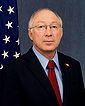
. The Jack Dempsey Museum is located on the town's main street. - Ken SalazarKen SalazarKenneth Lee "Ken" Salazar is the current United States Secretary of the Interior, in the administration of President Barack Obama. A member of the Democratic Party, he previously served as a United States Senator from Colorado from 2005 to 2009. He and Mel Martinez were the first Hispanic U.S...
Secretary of the Interior, Former U. S. Senator, Democrat, first elected 2004 for a six-year term. Former Attorney General for the State of Colorado. - John SalazarJohn SalazarJohn Tony Salazar is the former Congressman for , serving from 2005 until 2011. He is a member of the Democratic Party. Following his service in Congress, he was appointed as Commissioner of the Colorado Department of Agriculture in the Cabinet of Governor John Hickenlooper in 2011.-Early life,...
Commissioner of the Colorado Department of AgricultureColorado Department of AgricultureThe Colorado Department of Agriculture manages agriculture in the U.S. State of Colorado. Former U.S. Congressman John Salazar was appointed as Commissioner of the Department in 2011.-Mission:According to their mission statement,...
since 2011 and U.S. Congressman from Colorado's 3rd congressional districtColorado's 3rd congressional districtColorado's 3rd congressional district is a congressional district in the U.S. state of Colorado. The district is located in western and south central Colorado, encompassing most of the rural Western Slope...
from 2005 to 2011 - Anthony "Tony" Dunn, former defensive end in the National Football League. Tony played college football for the University of Northern ColoradoUniversity of Northern Colorado-Organization:The University of Northern Colorado offers 100 undergraduate programs and more than 100 graduate programs. The university has a satellite campus in Denver, Colorado...
where he received honors as a Div. II All-American, 3-time All-Conference, UNC Male athlete of the year. In 2003 Tony signed a free-agent contract with the Tennessee TitansTennessee TitansThe Tennessee Titans are a professional American football team based in Nashville, Tennessee, United States. They are members of the South Division of the American Football Conference in the National Football League . Previously known as the Houston Oilers, the team began play in 1960 as a charter...
. Dunn also played for the Arena Football League's Colorado Crush. Notably, Tony is the only All-American produced by the stellar coaching of Larry Jo Hunt.
Turquoise mine
Turquoise
Turquoise is an opaque, blue-to-green mineral that is a hydrous phosphate of copper and aluminium, with the chemical formula CuAl648·4. It is rare and valuable in finer grades and has been prized as a gem and ornamental stone for thousands of years owing to its unique hue...
is mined east of Manassa, in south central Colorado. It is known for its blue-green to green color with a golden or brown, non-webbed matrix. The Manassa mine is still in production, and owned by the King family, thus the alternate name sometimes used for this turquoise. This stone is a favorite of many; the beautiful green color is very striking, excellent when used in gold.
This site, originally mined by Ancestral Pueblo peoples, was rediscovered in 1890 by gold prospector I.P. King, and his descendants still work the claim. King’s Manassa turquoise is best known for its brilliant greens and golden matrices, but blue and blue-green turquoise was found amid these deposits as well.
Jewelry manufacturing
The Manassa area has long been known for its beautiful silver and turquoise jewelry and also for the production of fine pewter items.While some turquoise has been mined in the low hills east of Manassa, most of the jewelry industry in Manassa, and nearby, has utilized and polished the raw turquoise found in the copper and silver mines of Arizona and Nevada. Additionally, coral from the seas and other semiprecious cabachons and cut stones have been added to silver and gold jewelry.
Media
The Valley Courier Newspaper in Alamosa, Colorado, and the SLV Dweller, "a website dedicated to all things San Luis Valley," are two media outlets covering events in and near Manassa.Conejos County Official Website
Political representation
- Colorado State House District 32 (Ed Vigil, D-San Luis)
- Colorado State Senate District 5 (Gail Schwartz, D-Snowmass Village)
- U. S. Representative District 3 (John Salazar, D-Manassa)
- United States Senators: Mark Udall (D-Boulder), and Michael Bennet (D-Denver)
External links
- Town of Manassa contacts
- The Manassa Project Information about the Manassa Pioneer Day Celebration
- SLV Dweller - Since 2002, SLV Dweller has served as an agglomeration of San Luis Valley news and information from varied sources.
- Comprehensive Collection of video and quite a few photographs of Manassa and the surrounding area, as well as a collection of stories and articles from the San Luis Valley Dweller.
- Various Pictures of Sites Around Manassa and other information such as climate, population, income, et cetera.
- Beautiful pictures of the San Luis Valley, including one of the San Luis hills east of Manassa
- Photographs These are photographs of sites, not in Manassa, but within Conejos County, such as the new courthouse in the town of Conejos and the oldest church in the State of Colorado, located in Guadalupe