
Manam
Encyclopedia
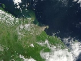
Manam, known locally as Manam Motu, is an island located in the Bismarck Sea
across the Stephan Strait from the northeast coast of mainland Papua New Guinea
. The island is 10 kilometers wide, and was created by the activity of the Manam Volcano, one of the country’s most active. It was inhabited until 2004, but it is now abandoned and its residents resettled elsewhere in Papua New Guinea. Prior to the most recent activity, the island was reached by boat from the mainland from nearby Bogia.
ic-andesitic
stratovolcano
, and despite remarkably symmetrical lower flanks has four distinct valleys, locally known as "avalanche valleys" due to their ability to focus avalanches and particularly pyroclastic flow
s generated at the summit. These valleys represent the highest-risk areas during eruptions, and, when the island was inhabited, were typically the first areas to be evacuated during heightened activity. The earliest documented eruption of Manam was in 1616.
 Thirteen local residents were killed during an eruption on 3 December 1996, when pyroclastic flows reached the village of Budua.
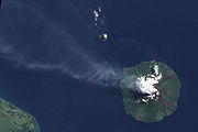
In November 2004, a major eruption forced the emergency evacuation of over 9,000 inhabitants of the island. The eruption began October 24 but was not seen as a major threat until the wind changed pushing ash and debris towards inhabited areas. Five people died during the eruption. On December 11, the threat was downgraded due to a reduction in activity. There remain significant problems at Bogia on the mainland where the evacuees are currently residing in resettlement camps at Mangem, Asarumba and Potsdam.
In March 2007 the government of Papua New Guinea made a large area of land available for permanent resettlement of displaced islanders at Andarum near Bogia. Also in March 2007, three people were killed by mudslides on the northern part of the island.
Bismarck Sea
The Bismarck Sea lies in the southwestern Pacific Ocean to the north of the island of Papua New Guinea and to the south of the Bismarck Archipelago and Admiralty Islands. Like the Bismarck archipelago, it is named in honour of the German chancellor Otto von Bismarck...
across the Stephan Strait from the northeast coast of mainland Papua New Guinea
Papua New Guinea
Papua New Guinea , officially the Independent State of Papua New Guinea, is a country in Oceania, occupying the eastern half of the island of New Guinea and numerous offshore islands...
. The island is 10 kilometers wide, and was created by the activity of the Manam Volcano, one of the country’s most active. It was inhabited until 2004, but it is now abandoned and its residents resettled elsewhere in Papua New Guinea. Prior to the most recent activity, the island was reached by boat from the mainland from nearby Bogia.
Geology
Manam is a basaltBasalt
Basalt is a common extrusive volcanic rock. It is usually grey to black and fine-grained due to rapid cooling of lava at the surface of a planet. It may be porphyritic containing larger crystals in a fine matrix, or vesicular, or frothy scoria. Unweathered basalt is black or grey...
ic-andesitic
Andesite
Andesite is an extrusive igneous, volcanic rock, of intermediate composition, with aphanitic to porphyritic texture. In a general sense, it is the intermediate type between basalt and dacite. The mineral assemblage is typically dominated by plagioclase plus pyroxene and/or hornblende. Magnetite,...
stratovolcano
Stratovolcano
A stratovolcano, also known as a composite volcano, is a tall, conical volcano built up by many layers of hardened lava, tephra, pumice, and volcanic ash. Unlike shield volcanoes, stratovolcanoes are characterized by a steep profile and periodic, explosive eruptions...
, and despite remarkably symmetrical lower flanks has four distinct valleys, locally known as "avalanche valleys" due to their ability to focus avalanches and particularly pyroclastic flow
Pyroclastic flow
A pyroclastic flow is a fast-moving current of superheated gas and rock , which reaches speeds moving away from a volcano of up to 700 km/h . The flows normally hug the ground and travel downhill, or spread laterally under gravity...
s generated at the summit. These valleys represent the highest-risk areas during eruptions, and, when the island was inhabited, were typically the first areas to be evacuated during heightened activity. The earliest documented eruption of Manam was in 1616.
Eruptions and hazards
In November 2004, a major eruption forced the emergency evacuation of over 9,000 inhabitants of the island. The eruption began October 24 but was not seen as a major threat until the wind changed pushing ash and debris towards inhabited areas. Five people died during the eruption. On December 11, the threat was downgraded due to a reduction in activity. There remain significant problems at Bogia on the mainland where the evacuees are currently residing in resettlement camps at Mangem, Asarumba and Potsdam.
In March 2007 the government of Papua New Guinea made a large area of land available for permanent resettlement of displaced islanders at Andarum near Bogia. Also in March 2007, three people were killed by mudslides on the northern part of the island.
Residents
Manam Islanders have their own language called Manam Pile (literally "Manam talk"), which is spoken on Manam and the nearby Boisa Islands. Manam islanders have a reputation in Papua New Guinea for musicianship and have produced several locally renowned musicians.External links
- http://www.radioaustralia.net.au/news/stories/s1876049.htm