

Main Western railway line, New South Wales
Encyclopedia
The Main Western Railway is a major railway in New South Wales
, Australia
. It runs through the Blue Mountains, Central West
, North West Slopes and the Far West regions.
 The Main Western Railway Line is a westwards continuation of what is known as the Main Suburban Line between Sydney Central station
and Parramatta
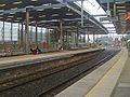
. The line is six electrified railway tracks between Central and Strathfield
, where the Main Northern line
branches off. The line is then four tracks as it passes through Lidcombe
, where the Main Southern Line
branches off, and then through the Sydney suburbs of Parramatta and Blacktown
, where the Richmond railway line branches off. At St Marys
, the line becomes two tracks as it passes through Penrith
and Emu Plains
, the extent of Sydney suburban passenger train operation. From Emu Plains, the line traverses the Blue Mountains passing through the townships of Katoomba
and Mount Victoria
before descending down the western side of the Blue Mountains through ten tunnels to the town of Lithgow
. Lithgow is the extent of electric passenger train services, although the electric wires extend to the town of Bowenfels
west of Lithgow. The line then proceeds through Wallerawang, where the line becomes single track, and then passes through Tarana
, Bathurst, Blayney
, Orange
(where the Broken Hill line branches), Wellington
, Dubbo, Narromine
, Nevertire
, Nyngan
, Byrock and Bourke
. The section between Nyngan and Bourke is now closed. A daily passenger train service operates as far as Dubbo.
 The Sydney Railway Company, a private company established to serve the interests of the port of Sydney, announced proposals to build a railway line to Bathurst
in 1848. The company was taken over by the New South Wales government in 1854, and in 1855 the first railway in the state was opened between Sydney
and the present-day Granville (see Rail transport in New South Wales
). This railway was extended from Granville to the current Parramatta station and Blacktown in 1860 and Penrith
in 1863.
The railway then crossed the Blue Mountains between 1867 and 1869. The Blue Mountains were a significant geographical barrier to the development of western New South Wales, and the crossing required significant feats of engineering for the railways, including two 'Zig Zags': one for the ascent at Lapstone, and another for the western descent. The first "little" zigzag
line opened near Glenbrook
in 1867 as part of the ascent of Lapstone Hill
on a gradient of 1 in 30-33. It was built with comparatively light earthwork, although it included a substantial seven-span sandstone viaduct (the Knapsack Viaduct) built by engineer, John Whitton
. By 1910, the line was replaced with a gentler alignment with 1 in 60 (1.67%) grades. The line reached Wentworth Falls in 1867 and Mount Victoria in 1868.
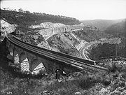
On the western descent form the Blue Mountains, the Lithgow Zig Zag Railway
, was constructed between 1866 and 1869. It was laid out in the shape of a 'Z' including reversing points
. It involved extremely heavy rock cuttings, three fine stone viaducts with 30 feet (9 m) semi-circular arches and a short tunnel. The Lithgow Zig Zag was replaced in 1910 by a deviation, which included ten tunnels.
From the western foot of the Blue Mountains, the line was promptly extended to Wallerawang by 1870, Tarana
in 1872, Bathurst, Blayney
in 1876 and Orange
in 1877.
By 1877, there was significant political pressure to minimise the diversion of trade from western New South Wales to Victoria and South Australia via river trade along the Darling and Murray Rivers. The town of Bourke
had become the key centre for pastoralists in western New South Wales since its formation in 1861. Provision was thus made to extend the line to Dubbo, reaching Wellington
in 1880 and Dubbo in 1881. At the time, Dubbo had grown into a town of strategic importance on the stock routes between northern New South Wales and the Victorian goldfields.
Beyond Dubbo, the railway opened up new land to European settlement, and was directly responsible for the development of townships. The line reached the future site of Narromine
in 1883, and the railway station was the first building in the future settlement. The line reached the site of Nevertire
in 1882, serving the nearby established village of Warren
(a branch opened to Warren in 1898). Construction reached the site of Nyngan
in 1883, with the nearby coach-stop village of Canonbar moving in its entirely to establish the town of Nyngan. Beyond Nyngan, the line swept across the plains in a straight line for 116 miles (186.7 km), then the longest stretch of straight railway line in the world. It reached the temporary terminus of Byrock
in 1884 before reaching its final destination of Bourke
in 1885.
Wool and livestock was the main source of goods traffic on the line throughout its life. In the 1890s, a severe drought caused a significant downturn in traffic, and additional lines to Brewarrina (in 1901) and Walgett (in 1908) reduced its catchment area. The line beyond Dubbo became loss-making in 1901, and continued that way throughout its existence. Tonnages increased following World War 2, but declined from the 1970s. Passenger services beyond Dubbo ended in 1974.
In the 1950s, the inner section of the line over the Blue Mountains was electrified
primarily as a means of easing the haulage of coal freight from the western coalfields to the coastal ports, but a by-product of this programme was the introduction of electric interurban passenger services as far west as Bowenfels, later cut back to the current terminus of Lithgow. Since the late 1990s goods trains are now exclusively diesel hauled, with the only electric trains being passenger services using double deck interurban cars.
In the 1990s the operate of interstate freight, the National Rail Corporation
, made the decision to divert Sydney- Perth traffic from the Blue Mountains section, to travel via the Main South
to Cootamundra, and then via the cross country line to Parkes
. This resulted in reduced goods traffic and subsequent reduction of the line between Wallerawang and Tarana from double to single track. Significant flooding saw the line cut between Nyngan and Bourke in 1989, and the army destroyed a section of track north of Nyngan to relieve flood waters surrounding the town. It was not financially viable to repair and maintain the line, and the line was thus abandoned between Nyngan and Bourke.
(via the Broken Hill line), and the section to Lithgow carries electric commuter trains to and from Sydney (the Blue Mountains Line).
New South Wales
New South Wales is a state of :Australia, located in the east of the country. It is bordered by Queensland, Victoria and South Australia to the north, south and west respectively. To the east, the state is bordered by the Tasman Sea, which forms part of the Pacific Ocean. New South Wales...
, Australia
Australia
Australia , officially the Commonwealth of Australia, is a country in the Southern Hemisphere comprising the mainland of the Australian continent, the island of Tasmania, and numerous smaller islands in the Indian and Pacific Oceans. It is the world's sixth-largest country by total area...
. It runs through the Blue Mountains, Central West
Central West, New South Wales
The Central West region refers to the area west of the Blue Mountains, New South Wales, Australia. It has an area of 63,262 square kilometers....
, North West Slopes and the Far West regions.
Description of route
Central railway station, Sydney
Central Railway Station, the largest railway station in Australia, is at the southern end of the Sydney CBD. It services almost all the lines on the CityRail network, and is the major terminus for interurban and interstate rail services...
and Parramatta
Parramatta, New South Wales
Parramatta is a suburb of Sydney, in the state of New South Wales, Australia. It is located in Greater Western Sydney west of the Sydney central business district on the banks of the Parramatta River. Parramatta is the administrative seat of the Local Government Area of the City of Parramatta...
. The line is six electrified railway tracks between Central and Strathfield
Strathfield, New South Wales
Strathfield is an Inner West suburb of Sydney, in the state of New South Wales, Australia. Strathfield is located 14 kilometres west of the Sydney central business district and is the administrative centre of the local government area of the Municipality of Strathfield...
, where the Main Northern line
Main North railway line, New South Wales
The Main North Line is a major railway in New South Wales, Australia. It runs through the Central Coast, Hunter and the New England regions. The line was the original main line between Sydney and Brisbane, however this required a change of gauge at Wallangarra...
branches off. The line is then four tracks as it passes through Lidcombe
Lidcombe, New South Wales
Lidcombe is a suburb in western Sydney, in the state of New South Wales Australia. Lidcombe is located 14 kilometres west of the Sydney central business district, in the local government area of Auburn Council....
, where the Main Southern Line
Main Southern railway line, New South Wales
The Main Southern Railway is a major railway in New South Wales, Australia. It runs through the Southern Highlands, Southern Tablelands, South West Slopes and the Riverina regions.- Description of route :...
branches off, and then through the Sydney suburbs of Parramatta and Blacktown
Blacktown, New South Wales
Blacktown is a suburb in the City of Blacktown, in Western Sydney, in the state of New South Wales, Australia. Blacktown is located 34 kilometres west of the Sydney central business district and is the administrative centre of the local government area of City of Blacktown.Blacktown is the largest...
, where the Richmond railway line branches off. At St Marys
St Marys, New South Wales
St Marys is a suburb in western Sydney, in the state of New South Wales Australia. St Marys is located 45 kilometres west of the Sydney central business district, in the local government area of the City of Penrith....
, the line becomes two tracks as it passes through Penrith
Penrith, New South Wales
Penrith is a suburb in western Sydney, in the state of New South Wales, Australia. Penrith is located west of the Sydney central business district and is the administrative centre for the local government area of the City of Penrith...
and Emu Plains
Emu Plains, New South Wales
Emu Plains is a town, in the state of New South Wales, Australia. Emu Plains is located 58 kilometres west of the Sydney central business district, in the local government area of the City of Penrith and is part of the Greater Western Sydney region....
, the extent of Sydney suburban passenger train operation. From Emu Plains, the line traverses the Blue Mountains passing through the townships of Katoomba
Katoomba, New South Wales
Katoomba is the chief town of the City of Blue Mountains in New South Wales, Australia and the administrative headquarters of Blue Mountains City Council. It is on the Great Western Highway 110 kilometres west of Sydney and 39 kilometres south-east of Lithgow. Katoomba railway station is on the...
and Mount Victoria
Mount Victoria, New South Wales
Mount Victoria is a small township in the Blue Mountains of New South Wales, Australia. It is the westernmost village in the City of Blue Mountains, located approximately 120 kilometres via road from Sydney and 1043 metres above sea-level...
before descending down the western side of the Blue Mountains through ten tunnels to the town of Lithgow
Lithgow, New South Wales
Lithgow is a city in the Central Tablelands of New South Wales, Australia and is the centre of the local political division City of Lithgow. It is located in a mountain valley named Lithgow's Valley by John Oxley in honour of William Lithgow, the first Auditor-General of New South Wales.Lithgow is...
. Lithgow is the extent of electric passenger train services, although the electric wires extend to the town of Bowenfels
Bowenfels, New South Wales
Bowenfels is a small town on the western outskirts of Lithgow, New South Wales, Australia.-History:The town was founded in the 1830s to service travellers along the new road to Bathurst, which opened in 1832. The town was the first settlement in the valley and pre-dated Lithgow by 40 years...
west of Lithgow. The line then proceeds through Wallerawang, where the line becomes single track, and then passes through Tarana
Tarana, New South Wales
Tarana is a small town in the Central West of New South Wales, Australia in the City of Lithgow.It is the former junction of the Oberon Branch railway with the Main Western Line. This branch line was notable for its steep 1 in 30 gradients and sharp 100 m curves. This little station could be...
, Bathurst, Blayney
Blayney, New South Wales
Blayney is a farming town and administrative centre with a population of 2,745 in 2006, in the Central West region of New South Wales, Australia...
, Orange
Orange, New South Wales
Orange is a city in the Central West region of New South Wales, Australia. It is west of the state capital, Sydney, at an altitude of . Orange has an estimated population of 39,329 and the city is a major provincial centre....
(where the Broken Hill line branches), Wellington
Wellington, New South Wales
Wellington is a town in inland New South Wales, Australia located at the junction of the Macquarie and Bell Rivers. The town is the administrative centre of the Wellington Shire Local Government Area. The town is 362 kilometres from Sydney on the Great Western Highway and Mitchell Highway...
, Dubbo, Narromine
Narromine, New South Wales
Narromine is a town located about 40 kilometres west of Dubbo in the Orana region of New South Wales, Australia. It is the centre of Narromine Shire. At the 2006 census, Narromine had a population of 3,599 people...
, Nevertire
Nevertire, New South Wales
Nevertire is a rural village in New South Wales, Australia. It is located at the junction of the Mitchell Highway and the Oxley Highway, in Warren Shire. Nevertire is about 525 kilometres northwest of Sydney, 68 km north-west of Narromine and about 90 km from Dubbo. It is about...
, Nyngan
Nyngan, New South Wales
Nyngan [pr: ning-g'n] is a town in the central west of New South Wales, Australia. It is located in the Bogan Shire Local Government Area. At the 2006 census, Nyngan had a population of 1,975 people. Nyngan is situated on the Bogan River between Narromine and Bourke, on the junction of the...
, Byrock and Bourke
Bourke, New South Wales
-Transportation:Bourke can be reached by the Mitchell Highway, with additional sealed roads from town to the north , east and south . The town is also served by Bourke Airport and has Countrylink bus service to other regional centres, like Dubbo...
. The section between Nyngan and Bourke is now closed. A daily passenger train service operates as far as Dubbo.
History
Bathurst, New South Wales
-CBD and suburbs:Bathurst's CBD is located on William, George, Howick, Russell, and Durham Streets. The CBD is approximately 25 hectares and surrounds two city blocks. Within this block layout is banking, government services, shopping centres, retail shops, a park* and monuments...
in 1848. The company was taken over by the New South Wales government in 1854, and in 1855 the first railway in the state was opened between Sydney
Sydney
Sydney is the most populous city in Australia and the state capital of New South Wales. Sydney is located on Australia's south-east coast of the Tasman Sea. As of June 2010, the greater metropolitan area had an approximate population of 4.6 million people...
and the present-day Granville (see Rail transport in New South Wales
Rail transport in New South Wales
The Australian state of New South Wales has an extensive network of railways, which were integral to the growth and development of the state. The vast majority of railway lines were government built and operated, but there were also several private railways, some of which operate to this...
). This railway was extended from Granville to the current Parramatta station and Blacktown in 1860 and Penrith
Penrith railway station, Sydney
Penrith railway station is a railway station on the CityRail network in New South Wales, Australia. Located in the Sydney suburb of Penrith, the station serves as a major interchange between Western line, Blue Mountains line trains. Western-bound CountryLink XPT and Xplorer services also stop here...
in 1863.
The railway then crossed the Blue Mountains between 1867 and 1869. The Blue Mountains were a significant geographical barrier to the development of western New South Wales, and the crossing required significant feats of engineering for the railways, including two 'Zig Zags': one for the ascent at Lapstone, and another for the western descent. The first "little" zigzag
Lapstone Zig Zag
The Lapstone Zig Zag was a ##Zig Zag #railway#|zig zag railway## built near ##Lapstone, New South Wales|Lapstone## on the ##Main Western railway line, New South Wales|Great Western Railway## of ##New South Wales## in ##Australia## between 1863 and 1865, to overcome an otherwise insurmountable climb...
line opened near Glenbrook
Glenbrook, New South Wales
Glenbrook is a suburb of the Lower Blue Mountains of New South Wales, Australia. It is located 70 kilometres west of Sydney in the local government area of the City of Blue Mountains. At the 2006 census, Glenbrook had a population of 5,138 people....
in 1867 as part of the ascent of Lapstone Hill
Lapstone, New South Wales
Lapstone is a small village on the eastern escarpment of the Blue Mountains in New South Wales, Australia. Lapstone is located 62 kilometres west of Sydney in the local government area of the City of Blue Mountains and is part of the federal electorate of Macquarie. The village consists mostly of...
on a gradient of 1 in 30-33. It was built with comparatively light earthwork, although it included a substantial seven-span sandstone viaduct (the Knapsack Viaduct) built by engineer, John Whitton
John Whitton
John Whitton was appointed Engineer-in-Charge for the New South Wales Railways, Australia, in January 1867. Over the next 32 years he completed 2811 miles of railway around NSW and Victoria...
. By 1910, the line was replaced with a gentler alignment with 1 in 60 (1.67%) grades. The line reached Wentworth Falls in 1867 and Mount Victoria in 1868.
On the western descent form the Blue Mountains, the Lithgow Zig Zag Railway
Zig Zag Railway
The Zig Zag Railway is a heritage railway at Lithgow in New South Wales, Australia on the site of the famous Great or Lithgow Zig Zag which operated between 1869 and 1910. As built, the line formed part of the Main West line from Sydney across the Blue Mountains and served to lower the line from...
, was constructed between 1866 and 1869. It was laid out in the shape of a 'Z' including reversing points
Railroad switch
A railroad switch, turnout or [set of] points is a mechanical installation enabling railway trains to be guided from one track to another at a railway junction....
. It involved extremely heavy rock cuttings, three fine stone viaducts with 30 feet (9 m) semi-circular arches and a short tunnel. The Lithgow Zig Zag was replaced in 1910 by a deviation, which included ten tunnels.
From the western foot of the Blue Mountains, the line was promptly extended to Wallerawang by 1870, Tarana
Tarana, New South Wales
Tarana is a small town in the Central West of New South Wales, Australia in the City of Lithgow.It is the former junction of the Oberon Branch railway with the Main Western Line. This branch line was notable for its steep 1 in 30 gradients and sharp 100 m curves. This little station could be...
in 1872, Bathurst, Blayney
Blayney, New South Wales
Blayney is a farming town and administrative centre with a population of 2,745 in 2006, in the Central West region of New South Wales, Australia...
in 1876 and Orange
Orange, New South Wales
Orange is a city in the Central West region of New South Wales, Australia. It is west of the state capital, Sydney, at an altitude of . Orange has an estimated population of 39,329 and the city is a major provincial centre....
in 1877.
By 1877, there was significant political pressure to minimise the diversion of trade from western New South Wales to Victoria and South Australia via river trade along the Darling and Murray Rivers. The town of Bourke
Bourke, New South Wales
-Transportation:Bourke can be reached by the Mitchell Highway, with additional sealed roads from town to the north , east and south . The town is also served by Bourke Airport and has Countrylink bus service to other regional centres, like Dubbo...
had become the key centre for pastoralists in western New South Wales since its formation in 1861. Provision was thus made to extend the line to Dubbo, reaching Wellington
Wellington, New South Wales
Wellington is a town in inland New South Wales, Australia located at the junction of the Macquarie and Bell Rivers. The town is the administrative centre of the Wellington Shire Local Government Area. The town is 362 kilometres from Sydney on the Great Western Highway and Mitchell Highway...
in 1880 and Dubbo in 1881. At the time, Dubbo had grown into a town of strategic importance on the stock routes between northern New South Wales and the Victorian goldfields.
Beyond Dubbo, the railway opened up new land to European settlement, and was directly responsible for the development of townships. The line reached the future site of Narromine
Narromine, New South Wales
Narromine is a town located about 40 kilometres west of Dubbo in the Orana region of New South Wales, Australia. It is the centre of Narromine Shire. At the 2006 census, Narromine had a population of 3,599 people...
in 1883, and the railway station was the first building in the future settlement. The line reached the site of Nevertire
Nevertire, New South Wales
Nevertire is a rural village in New South Wales, Australia. It is located at the junction of the Mitchell Highway and the Oxley Highway, in Warren Shire. Nevertire is about 525 kilometres northwest of Sydney, 68 km north-west of Narromine and about 90 km from Dubbo. It is about...
in 1882, serving the nearby established village of Warren
Warren, New South Wales
Warren is a town and the seat of a local government area, Warren Shire, on the Macquarie River in central New South Wales, Australia. The town is located on the Oxley Highway 120 kilometres north west of Dubbo. It was laid out in the 1860s and incorporated as a municipality in 1895. The railway...
(a branch opened to Warren in 1898). Construction reached the site of Nyngan
Nyngan, New South Wales
Nyngan [pr: ning-g'n] is a town in the central west of New South Wales, Australia. It is located in the Bogan Shire Local Government Area. At the 2006 census, Nyngan had a population of 1,975 people. Nyngan is situated on the Bogan River between Narromine and Bourke, on the junction of the...
in 1883, with the nearby coach-stop village of Canonbar moving in its entirely to establish the town of Nyngan. Beyond Nyngan, the line swept across the plains in a straight line for 116 miles (186.7 km), then the longest stretch of straight railway line in the world. It reached the temporary terminus of Byrock
Byrock, New South Wales
Byrock is a small village in north western New South Wales, Australia in Bourke Shire. In 2006, Byrock had a population of 90 people.It is named after a rock hole, called Bai by the Nyammba tribe...
in 1884 before reaching its final destination of Bourke
Bourke, New South Wales
-Transportation:Bourke can be reached by the Mitchell Highway, with additional sealed roads from town to the north , east and south . The town is also served by Bourke Airport and has Countrylink bus service to other regional centres, like Dubbo...
in 1885.
Wool and livestock was the main source of goods traffic on the line throughout its life. In the 1890s, a severe drought caused a significant downturn in traffic, and additional lines to Brewarrina (in 1901) and Walgett (in 1908) reduced its catchment area. The line beyond Dubbo became loss-making in 1901, and continued that way throughout its existence. Tonnages increased following World War 2, but declined from the 1970s. Passenger services beyond Dubbo ended in 1974.
In the 1950s, the inner section of the line over the Blue Mountains was electrified
Railway electrification system
A railway electrification system supplies electrical energy to railway locomotives and multiple units as well as trams so that they can operate without having an on-board prime mover. There are several different electrification systems in use throughout the world...
primarily as a means of easing the haulage of coal freight from the western coalfields to the coastal ports, but a by-product of this programme was the introduction of electric interurban passenger services as far west as Bowenfels, later cut back to the current terminus of Lithgow. Since the late 1990s goods trains are now exclusively diesel hauled, with the only electric trains being passenger services using double deck interurban cars.
In the 1990s the operate of interstate freight, the National Rail Corporation
National Rail Corporation
The National Rail Corporation was a rail operator in Australia. The Australian Government, New South Wales and Victoria established the National Rail Corporation in 1992...
, made the decision to divert Sydney- Perth traffic from the Blue Mountains section, to travel via the Main South
Main Southern railway line, New South Wales
The Main Southern Railway is a major railway in New South Wales, Australia. It runs through the Southern Highlands, Southern Tablelands, South West Slopes and the Riverina regions.- Description of route :...
to Cootamundra, and then via the cross country line to Parkes
Parkes, New South Wales
- Transport :Parkes has a local bus service provided by Western Road Liners, which acquired Harris Bus Lines in March 2006. The Indian Pacific also stops twice a week, as well as the Broken Hill Outback Xplorer service, run by CountryLink, which heads to Broken Hill on Mondays and Sydney on...
. This resulted in reduced goods traffic and subsequent reduction of the line between Wallerawang and Tarana from double to single track. Significant flooding saw the line cut between Nyngan and Bourke in 1989, and the army destroyed a section of track north of Nyngan to relieve flood waters surrounding the town. It was not financially viable to repair and maintain the line, and the line was thus abandoned between Nyngan and Bourke.
Branch lines
Many branch lines were built from the Main Western Line, some of which remain operational.- A branch line ran from Newnes Junction (near Clarence) to NewnesNewnes, New South WalesNewnes located in the Wolgan Valley, New South Wales, Australia, and partly surrounded by the Wollemi National Park, is an abandoned oil shale mining site that was operational in the early 20th centuries...
(now in the Wollemi National ParkWollemi National ParkWollemi National Park is the second largest national park in New South Wales, and contains most of the largest wilderness area, the Wollemi Wilderness...
) from 1907 to 1932 to service an oil shaleOil shaleOil shale, an organic-rich fine-grained sedimentary rock, contains significant amounts of kerogen from which liquid hydrocarbons called shale oil can be produced...
mine. Its tunnelsNewnes Glow Worm TunnelThe Newnes glow worm tunnel is a disused railway tunnel in the Wolgan Valley, New South Wales, Australia, that is famous for its resident glow worms, the bioluminescent larvae of Arachnocampa richardsae, a type of fungus gnat.-Description and history:...
have become home to glow wormsArachnocampaArachnocampa is a genus of four fungus gnat species which are, in their larval stage, glowworms. They are found mostly in New Zealand and Australia in caves and grottos, or sheltered places in forests....
since their abandonment.
- The Gwabegar line opened from Wallerawang to CaperteeCapertee, New South WalesCapertee is a village 45km north of Lithgow, New South Wales, Australia located on an elevated site above the Capertee Valley. In 2006, the town had a population of 72 people. Situated on the Castlereagh Highway between Lithgow and Mudgee, Capertee is surrounded by National Parks and grazing land...
in 1882, Mudgee in 1884, GulgongGulgong, New South WalesGulgong is a 19th century gold rush town in the Central-West of the Australian state of New South Wales. The town is located about north west of Sydney, and about 30 km north of Mudgee along the Castlereagh Highway. At the 2006 census, Gulgong had a population of 1,907 people...
in 1909, Craboon, and DunedooDunedoo, New South WalesDunedoo ) is a village of 836 inhabitants situated within the Warrumbungle Shire of central western New South Wales, Australia. Dunedoo is well known to Australian travellers due to its distinctive name...
in 1910, Merrygoen, BinnawayBinnaway, New South WalesBinnaway is a small town located on the Castlereagh River in central New South Wales near the larger centre of Coonabarabran, which is about 35 kilometres to the north. In 2006, the town had a population of 495 people. The road linking these two towns closely follows the meandering Castlereagh River...
and CoonabarabranCoonabarabran, New South WalesCoonabarabran is a town in Warrumbungle Shire in northern New South Wales, Australia. At the 2006 census, the town had a population of 2,609.-History and description:...
in 1917 and Gwabegar in 1923. At one time it was proposed to extend it to Burren Junction to connect with the lines to WalgettWalgett, New South WalesWalgett is a town in North-West New South Wales, Australia and the seat of Walgett Shire. It is at the junction of the Barwon and Namoi rivers and near the junction of the Kamilaroi and Castlereagh Highways...
and Pokataroo (near CollarenebriCollarenebri, New South WalesCollarenebri is a town with a population of 478 people in north western New South Wales, Australia. It is situated in Walgett Shire, on the Barwon River approximately 75 km northeast of Walgett and south west of Mungindi on the Gwydir Highway. It is from Pokataroo which was the nearest...
). The section north of Coonabarabran has been abandoned.
- The Dubbo to Merrygoen line was opened in 1918, connecting with the Binnaway to Werris Creek line in 1923. These lines completed an inland route from JuneeJunee, New South WalesJunee is a medium sized town in the Riverina region of New South Wales, Australia. The town's prosperity and mixed services economy is based on a combination of agriculture, rail transport, light industry and government services, and in particular correctional services...
on the Main South lineMain Southern railway line, New South WalesThe Main Southern Railway is a major railway in New South Wales, Australia. It runs through the Southern Highlands, Southern Tablelands, South West Slopes and the Riverina regions.- Description of route :...
to the Hunter ValleyHunter ValleyThe Hunter Region, more commonly known as the Hunter Valley, is a region of New South Wales, Australia, extending from approximately to north of Sydney with an approximate population of 645,395 people. Most of the population of the Hunter Region lives within of the coast, with 55% of the entire...
.
- The Oberon branch connected Tarana with OberonOberon, New South Wales-See also:*Oberon Correctional Centre*Mount Trickett*Mount Bindo*Shooters Hill-External links:***...
from 1923 to 1979.
- The Broken Hill line, now the mainline between Sydney to Perth, was constructed as a branch from the Main West at Orange between 1885 and 1927.
- The Coonamble branch was built from Dubbo to GilgandraGilgandra, New South WalesGilgandra, is a town and Local Government Area in the Central West region of New South Wales, Australia. It is located on the junction of the Newell Highway, Oxley Highway and Castlereagh Highway. It can be reached in about six hours by car from Sydney. Like Coonabarabran, Gilgandra can be...
and CoonambleCoonamble, New South WalesCoonamble is a town on the central-western plains of New South Wales, Australia. It lies on the Castlereagh Highway north-west of Gilgandra. At the 2006 census, Coonamble had a population of 2,549...
in 1903.
- The Parkes- Narromine line was opened from Narromine as an overland route to the Broken Hill line at Parkes (and eventually to the Main South lineMain Southern railway line, New South WalesThe Main Southern Railway is a major railway in New South Wales, Australia. It runs through the Southern Highlands, Southern Tablelands, South West Slopes and the Riverina regions.- Description of route :...
at Junee). It opened to Peak HillPeak Hill, New South WalesPeak Hill is a town in Parkes Shire in the Central West of New South Wales, Australia. At the 2006 census, Peak Hill had a population of 946 people.It is on the Newell Highway and the Dubbo to Parkes railway line, completed to Peak Hill in 1910...
in 1910 and Parkes in 1914.
- The Warren line, a short branch from Nevertire to WarrenWarren, New South WalesWarren is a town and the seat of a local government area, Warren Shire, on the Macquarie River in central New South Wales, Australia. The town is located on the Oxley Highway 120 kilometres north west of Dubbo. It was laid out in the 1860s and incorporated as a municipality in 1895. The railway...
opened in 1898.
- The Cobar line was built from Nyngan to CobarCobar, New South Wales-Notable people:*Nik Kosef, former rugby league player for the Manly-Warringah Sea Eagles, 1996 premiership player, NSW & Australia representative*Ernie Toshack, cricketer, member of Bradman's Invincibles* Jemma Heather, state representative 4 times....
in 1894 and the CSA Mine (12 km northwest of Cobar) in 1963.
- The Brewarrina line line was built from ByrockByrock, New South WalesByrock is a small village in north western New South Wales, Australia in Bourke Shire. In 2006, Byrock had a population of 90 people.It is named after a rock hole, called Bai by the Nyammba tribe...
to BrewarrinaBrewarrina, New South WalesBrewarrina is a small town in North West New South Wales, Australia on the banks of the Barwon River in Brewarrina Shire. It is 98 km east of Bourke and west of Walgett on the Kamilaroi Highway, and 808 km from Sydney. Brewarrina has had its population decrease from 1,197 persons in...
in 1901 and closed in 1974.
Present operation
Goods traffic continues as far as Nyngan, to and from the Cobar branch which connects at this point. Passenger traffic (one train per day) operates to Dubbo. The section between Sydney and Orange carries the Indian Pacific train to PerthPerth, Western Australia
Perth is the capital and largest city of the Australian state of Western Australia and the fourth most populous city in Australia. The Perth metropolitan area has an estimated population of almost 1,700,000....
(via the Broken Hill line), and the section to Lithgow carries electric commuter trains to and from Sydney (the Blue Mountains Line).
Further reading
- Across the Tableland, Bathurst to Orange Singleton, C.C. Australian Railway Historical Society BulletinAustralian Railway HistoryAustralian Railway History , is the premier magazine covering railway history in Australia...
, June 1940 - Across the Tableland, Orange to Dubbo Singleton, C.C. Australian Railway Historical Society BulletinAustralian Railway HistoryAustralian Railway History , is the premier magazine covering railway history in Australia...
, July 1940 - The Western Plains Section, Dubbo to Bourke Singleton, C.C. Australian Railway Historical Society BulletinAustralian Railway HistoryAustralian Railway History , is the premier magazine covering railway history in Australia...
, September 1940