
Main Turkmen Canal
Encyclopedia
The Main Turkmen Canal was a large-scale irrigation
project in Soviet Turkmenistan
. The canal was intended to transport water from the Amu Darya
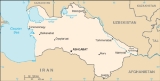
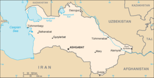
river to Krasnovodsk (now Türkmenbaşy), a city in Turkmenistan
on the coast of the Caspian Sea
. The canal was going to bring the water to the city along the course of the ancient, dried Uzboy River
bed.
. The project was supported by Hydrologist V, Tsinzerling, who estimated the volume of water taken from the river to be around 17-35 cu km of water, which, according to estimations, should not have injured the economy of Uzbekistan
or the ecology of the Aral Sea
. It was intended to fill Sarykamysskoe Lake and to take from 30 to 50 kubic kilometers per year for 4 to 8 years. This version was approved by the State Planning Committee of the USSR in 1932. The second plan was chosen. The length of the canal was assumed to be more than 1200 kilometers, beginning from Takhiatash, a town/city in Uzbekistan, then extended 10 km from the town of Nukus
to Krasnovodsk
which is a city on the Caspian Coast of Turkmenistan. However, the discharge of the water into the Caspian Sea
was not planned.
s, sluices, reservoir
s, hydroelectric power plants, diverters and conduits, with a length of more than 1000 kilometers was planned along the route of the canal. At the beginning of the canal at Takhiatash, Uzbekistan, there was an enormous weir built which had to be combined with the hydroelectric power plant. 25 percent of the water from the Amu Darya
was to be drained into the canal in order to drain the Aral Sea
. With the level of the Aral Sea lowered, the intention was to use the earth, which arose with the retreat of the sea, in agriculture, but the salt of the lower reaches of the Amu Darya river had to be lowered according to calculations.
The purpose of the canal was cotton
growing, mastery of the new earth in the Karakum Desert
, and also later, navigation from the Volga River
to the Amu Darya. It was planned that the use of ten thousand dump trucks
, bulldozers
and excavators
would be necessary to build the canal. The width of the canal
was planned to be more than 100 meters, the depth to be 6–7 meters. There was another projected 10 thousand kilometers of main and distributive canals, two thousand reservoirs and three hydroelectric power plants each producing 100 thousand kilowatts. Construction of the canal was intended to be finished by 1957.
(which at that time was part of the Uzbek Soviet Socialist Republic). They chose Urgench because it is where the railroad lines reached to. November 1950, construction workers approached the building site of the worker camps that would hold 2000 people. In December, they laid the new city of Takhiatash on the Amu Darya's west side. Before the city was built, on that site, stood two shelters that provided barge haulers protection from foul weather. When the city was first being constructed there were two camps beginning to be built in the city for 1500 prisoners or people.
Massive loads of goods from the entire country began to enter into Takhiatash, and according to recollections kept, the goods were stored very poorly. Substantial parts of the goods were considered un-usable because of the poor storage. In 1951, several camps and economic objects were built. On June 15, 1952 the railroad from Takhiatash to Chardzhou (now, Türkmenabat
) was opened. Infrastructure for the development of the city was created, searching expeditions were organized and aviation was connected. The number of workers during the construction is estimated to be around 10 thousand people, where more than half of them were prisoners.
began; running along a different route far to the south, it eventually reached a length of 1300 kilometers and irrigated a substantial part of Turkmenistan. The Qaraqum Canal still remains the most important canal of Turkmenistan.
Irrigation
Irrigation may be defined as the science of artificial application of water to the land or soil. It is used to assist in the growing of agricultural crops, maintenance of landscapes, and revegetation of disturbed soils in dry areas and during periods of inadequate rainfall...
project in Soviet Turkmenistan
Turkmen SSR
The Turkmen Soviet Socialist Republic , also known as the Turkmen SSR for short, was one of republics of the Soviet Union in Central Asia. It was initially established on 7 August 1921 as the Turkmen Oblast of the Turkestan ASSR. On 13 May 1925 it was transformed into Turkmen SSR and became a...
. The canal was intended to transport water from the Amu Darya
Amu Darya
The Amu Darya , also called Oxus and Amu River, is a major river in Central Asia. It is formed by the junction of the Vakhsh and Panj rivers...
river to Krasnovodsk (now Türkmenbaşy), a city in Turkmenistan
Turkmenistan
Turkmenistan , formerly also known as Turkmenia is one of the Turkic states in Central Asia. Until 1991, it was a constituent republic of the Soviet Union, the Turkmen Soviet Socialist Republic . Turkmenistan is one of the six independent Turkic states...
on the coast of the Caspian Sea
Caspian Sea
The Caspian Sea is the largest enclosed body of water on Earth by area, variously classed as the world's largest lake or a full-fledged sea. The sea has a surface area of and a volume of...
. The canal was going to bring the water to the city along the course of the ancient, dried Uzboy River
Uzboy River
The Uzboy River was a distributary of the Amu Darya which flowed through the northwestern part of the Karakum Desert of Turkmenistan until the 18th century, when it abruptly dried up, destroying in the process the Turkmen civilization which had thrived along its banks.Now a dry river channel and a...
bed.
Idea
The building of canals and channels for the irrigation of Turkmenistan began in the 1930s. In 1929, the Bassaga-Kerkinskiy Canal was completed at a length of 100 km. The development of the outlet design for the Amu Darya began in 1932. The design was to bring water from the Amu Darya across Turkmenistan and to the coast of the Caspian Sea, all in order to irrigate the Karakum DesertKarakum Desert
The Karakum Desert, also spelled Kara-Kum and Gara Gum is a desert in Central Asia. It occupies about 70 percent, or 350,000 km², of the area of Turkmenistan....
. The project was supported by Hydrologist V, Tsinzerling, who estimated the volume of water taken from the river to be around 17-35 cu km of water, which, according to estimations, should not have injured the economy of Uzbekistan
Uzbekistan
Uzbekistan , officially the Republic of Uzbekistan is a doubly landlocked country in Central Asia and one of the six independent Turkic states. It shares borders with Kazakhstan to the west and to the north, Kyrgyzstan and Tajikistan to the east, and Afghanistan and Turkmenistan to the south....
or the ecology of the Aral Sea
Aral Sea
The Aral Sea was a lake that lay between Kazakhstan in the north and Karakalpakstan, an autonomous region of Uzbekistan, in the south...
. It was intended to fill Sarykamysskoe Lake and to take from 30 to 50 kubic kilometers per year for 4 to 8 years. This version was approved by the State Planning Committee of the USSR in 1932. The second plan was chosen. The length of the canal was assumed to be more than 1200 kilometers, beginning from Takhiatash, a town/city in Uzbekistan, then extended 10 km from the town of Nukus
Nukus
Nukus is the sixth-largest city in Uzbekistan, and the capital of the autonomous Karakalpakstan Republic. It has a population of 260,000...
to Krasnovodsk
Türkmenbasy, Turkmenistan
Türkmenbaşy , formerly known as Krasnovodsk and, more properly, Kyzyl-Su, is a city in Balkan Province in Turkmenistan, on the Krasnovodsk Gulf of the Caspian Sea. It is located at latitude 40.0231 North; longitude 52.9697 East, at an altitude of 27 meters. The population was 86,800, mostly...
which is a city on the Caspian Coast of Turkmenistan. However, the discharge of the water into the Caspian Sea
Caspian Sea
The Caspian Sea is the largest enclosed body of water on Earth by area, variously classed as the world's largest lake or a full-fledged sea. The sea has a surface area of and a volume of...
was not planned.
The Canal
A system of weirWeir
A weir is a small overflow dam used to alter the flow characteristics of a river or stream. In most cases weirs take the form of a barrier across the river that causes water to pool behind the structure , but allows water to flow over the top...
s, sluices, reservoir
Reservoir
A reservoir , artificial lake or dam is used to store water.Reservoirs may be created in river valleys by the construction of a dam or may be built by excavation in the ground or by conventional construction techniques such as brickwork or cast concrete.The term reservoir may also be used to...
s, hydroelectric power plants, diverters and conduits, with a length of more than 1000 kilometers was planned along the route of the canal. At the beginning of the canal at Takhiatash, Uzbekistan, there was an enormous weir built which had to be combined with the hydroelectric power plant. 25 percent of the water from the Amu Darya
Amu Darya
The Amu Darya , also called Oxus and Amu River, is a major river in Central Asia. It is formed by the junction of the Vakhsh and Panj rivers...
was to be drained into the canal in order to drain the Aral Sea
Aral Sea
The Aral Sea was a lake that lay between Kazakhstan in the north and Karakalpakstan, an autonomous region of Uzbekistan, in the south...
. With the level of the Aral Sea lowered, the intention was to use the earth, which arose with the retreat of the sea, in agriculture, but the salt of the lower reaches of the Amu Darya river had to be lowered according to calculations.
The purpose of the canal was cotton
Cotton
Cotton is a soft, fluffy staple fiber that grows in a boll, or protective capsule, around the seeds of cotton plants of the genus Gossypium. The fiber is almost pure cellulose. The botanical purpose of cotton fiber is to aid in seed dispersal....
growing, mastery of the new earth in the Karakum Desert
Karakum Desert
The Karakum Desert, also spelled Kara-Kum and Gara Gum is a desert in Central Asia. It occupies about 70 percent, or 350,000 km², of the area of Turkmenistan....
, and also later, navigation from the Volga River
Volga River
The Volga is the largest river in Europe in terms of length, discharge, and watershed. It flows through central Russia, and is widely viewed as the national river of Russia. Out of the twenty largest cities of Russia, eleven, including the capital Moscow, are situated in the Volga's drainage...
to the Amu Darya. It was planned that the use of ten thousand dump trucks
Dump truck
A dump truck is a truck used for transporting loose material for construction. A typical dump truck is equipped with a hydraulically operated open-box bed hinged at the rear, the front of which can be lifted up to allow the contents to be deposited on the ground behind the truck at the site of...
, bulldozers
Bulldozer
A bulldozer is a crawler equipped with a substantial metal plate used to push large quantities of soil, sand, rubble, etc., during construction work and typically equipped at the rear with a claw-like device to loosen densely-compacted materials.Bulldozers can be found on a wide range of sites,...
and excavators
Excavator
Excavators are heavy construction equipment consisting of a boom, stick, bucket and cab on a rotating platform . The house sits atop an undercarriage with tracks or wheels. A cable-operated excavator uses winches and steel ropes to accomplish the movements. They are a natural progression from the...
would be necessary to build the canal. The width of the canal
Canal
Canals are man-made channels for water. There are two types of canal:#Waterways: navigable transportation canals used for carrying ships and boats shipping goods and conveying people, further subdivided into two kinds:...
was planned to be more than 100 meters, the depth to be 6–7 meters. There was another projected 10 thousand kilometers of main and distributive canals, two thousand reservoirs and three hydroelectric power plants each producing 100 thousand kilowatts. Construction of the canal was intended to be finished by 1957.
Construction
Building began after the decision of the Council of Ministers in September 1950. The construction was based out of UrgenchUrgench
Urgench is a city in western Uzbekistan. It is the capital of the Khorezm Province, on the Amu Darya River and the Shavat canal. The city is situated 450 km west of Bukhara across the Kyzyl Kum Desert. It is located at latitude 41° 32' 60N longitude 60° 37' 60E, at an altitude of 91 meters.The...
(which at that time was part of the Uzbek Soviet Socialist Republic). They chose Urgench because it is where the railroad lines reached to. November 1950, construction workers approached the building site of the worker camps that would hold 2000 people. In December, they laid the new city of Takhiatash on the Amu Darya's west side. Before the city was built, on that site, stood two shelters that provided barge haulers protection from foul weather. When the city was first being constructed there were two camps beginning to be built in the city for 1500 prisoners or people.
Massive loads of goods from the entire country began to enter into Takhiatash, and according to recollections kept, the goods were stored very poorly. Substantial parts of the goods were considered un-usable because of the poor storage. In 1951, several camps and economic objects were built. On June 15, 1952 the railroad from Takhiatash to Chardzhou (now, Türkmenabat
Türkmenabat
Türkmenabat , formerly and since the medieval times, Chardzhou , also spelled Çärjew, Chardjui, Charjou, Chardzhev, Charjev, Chärjew, or Charjew , ancient Amul, is a town in Turkmenistan, capital of Lebap Province...
) was opened. Infrastructure for the development of the city was created, searching expeditions were organized and aviation was connected. The number of workers during the construction is estimated to be around 10 thousand people, where more than half of them were prisoners.
End of an Idea
In 1953, after Stalin's death, the building of the Main Turkmen Canal was stopped. Instead, in 1954, the construction of the Qaraqum CanalQaraqum Canal
The Qaraqum Canal in Turkmenistan is one of the largest irrigation and water supply canals in the world...
began; running along a different route far to the south, it eventually reached a length of 1300 kilometers and irrigated a substantial part of Turkmenistan. The Qaraqum Canal still remains the most important canal of Turkmenistan.