

Macclesfield Bank
Encyclopedia
Atoll
An atoll is a coral island that encircles a lagoon partially or completely.- Usage :The word atoll comes from the Dhivehi word atholhu OED...
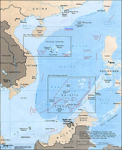
of underwater reefs and shoals in the South China Sea
South China Sea
The South China Sea is a marginal sea that is part of the Pacific Ocean, encompassing an area from the Singapore and Malacca Straits to the Strait of Taiwan of around...
and part of the disputed South China Sea Islands
South China Sea Islands
The South China Sea Islands consist of over 250 around 1-km² islands, atolls, cays, shoals, reefs, and sandbars in the South China Sea, most of which have no indigenous people, many of which are naturally under water at high tide, some of which are permanently submerged...
, centred around 16°00′N 114°30′E, east of the Paracel Islands
Paracel Islands
The Paracel Islands, also called Xisha Islands in Chinese and Hoàng Sa Islands in Vietnamese, is a group of islands under the administration of Hainan Province, The People's Republic of China. Vietnam and the Republic of China also claim sovereignty of these islands...
. Its length exceeds 130 km (81 mi) southwest-northeast, with a maximal width of more than 70 km (43 mi). With an area of 6448 km² (2,490 sq mi) within the outer rim of the reef, although completely submerged without any emergent cays or islets, it is one of the largest atolls of the world.
The broken coral reef rim of Macclesfield Bank, with a width of up to 8 km (5 mi), has depths of 11.8 m (39 ft) at Pygmy Shoal on the northeast end of the bank and depths of 11.6 to 18 m (59 ft) elsewhere. Within the lagoon, Walker Shoal marks the least known depth of 9.2 metres. In general, the central lagoon is very deep, with depths up to 100 metres.
Macclesfield Bank is claimed by the People's Republic of China
People's Republic of China
China , officially the People's Republic of China , is the most populous country in the world, with over 1.3 billion citizens. Located in East Asia, the country covers approximately 9.6 million square kilometres...
, Republic of China
Republic of China
The Republic of China , commonly known as Taiwan , is a unitary sovereign state located in East Asia. Originally based in mainland China, the Republic of China currently governs the island of Taiwan , which forms over 99% of its current territory, as well as Penghu, Kinmen, Matsu and other minor...
(Taiwan
Taiwan
Taiwan , also known, especially in the past, as Formosa , is the largest island of the same-named island group of East Asia in the western Pacific Ocean and located off the southeastern coast of mainland China. The island forms over 99% of the current territory of the Republic of China following...
), and the Philippines
Philippines
The Philippines , officially known as the Republic of the Philippines , is a country in Southeast Asia in the western Pacific Ocean. To its north across the Luzon Strait lies Taiwan. West across the South China Sea sits Vietnam...
. It is located east of the Paracel Islands
Paracel Islands
The Paracel Islands, also called Xisha Islands in Chinese and Hoàng Sa Islands in Vietnamese, is a group of islands under the administration of Hainan Province, The People's Republic of China. Vietnam and the Republic of China also claim sovereignty of these islands...
, distantly southwest of the Pratas Islands
Pratas Islands
The Pratas Islands or Dongsha Islands consists of three islands forming from an atoll located in northeastern South China Sea, southeast of Hong Kong. The islands are governed by the Republic of China . The People's Republic of China claims sovereignty over these islands along with all other...
and north of the Spratly Islands
Spratly Islands
The Spratly Islands are a group of more than 750 reefs, islets, atolls, cays and islands in the South China Sea. The archipelago lies off the coasts of the Philippines and Malaysia , about one third of the way from there to southern Vietnam. They comprise less than four square kilometers of land...
.
There are no military stations there. It is a rich fishing ground and difficult to navigate due to the shallow submerged reefs.
Geography
The elongated atoll consists of:| English English language English is a West Germanic language that arose in the Anglo-Saxon kingdoms of England and spread into what was to become south-east Scotland under the influence of the Anglian medieval kingdom of Northumbria... Name |
Romanized Romanization of Chinese The romanization of Mandarin Chinese is the use of the Latin alphabet to write Chinese. Because Chinese is a tonal language with a logographic script, its characters do not represent phonemes directly. There have been many systems of romanization throughout history... Name |
Chinese Chinese language The Chinese language is a language or language family consisting of varieties which are mutually intelligible to varying degrees. Originally the indigenous languages spoken by the Han Chinese in China, it forms one of the branches of Sino-Tibetan family of languages... Name |
Coordinates Geographic coordinate system A geographic coordinate system is a coordinate system that enables every location on the Earth to be specified by a set of numbers. The coordinates are often chosen such that one of the numbers represent vertical position, and two or three of the numbers represent horizontal position... |
|---|---|---|---|
| Siamese Shoal | Simen Ansha | 西門暗沙 | 15°58′N 114°03′E |
| Bankok Shoal | Bengu Ansha | 本固暗沙 | 16°00′N 114°06′E |
| Magpie Shoal | Meibin Ansha | 美濱暗沙 | 16°03′N 114°13′E |
| Carpenter Shoal | Luban Ansha | 魯班暗沙 | 16°04′N 114°18′E |
| Oliver Shoal | Lifu Ansha | 立夫暗沙 | 15°57′N 115°24′E |
| Pigmy (Pygmy) Shoal | Biwei Ansha | 比微暗沙 | 16°13′N 114°44′E |
| Engeria (Egeria) Bank | Yinji Ansha | 隱磯灘 | 16°03′N 114°56′E |
| Howard Shoal | Wuyong Ansha | 武勇暗沙 | 15°52′N 114°47′E |
| Learmonth Shoal | Jimeng Ansha | 濟猛暗沙 | 15°42′N 114°41′E |
| Plover Shoal | Haijiu Ansha | 海鳩暗沙 | 15°36′N 114°28′E |
| Addington Patch | Anding Lianjiao | 安定連礁 | 15°37′N 114°24′E |
| Smith Shoal | Meisi Ansha | 美溪暗沙 | 15°27′N 114°12′E |
| Bassett Shoal | Bude Ansha | 布德暗沙 | 15°27′N 114°10′E |
| Balfour Shoal | Pofu Ansha | 波洑暗沙 or伏洑暗沙 | 15°27′N 114°00′E |
| Parry Shoal | Paipo Ansha | 排波暗沙 | 15°29′N 113°51′E |
| Cawston Shoal | Guodian Ansha | 果淀暗沙 | 15°32′N 113°46′E |
| Penguin Bank | Paihong Ansha | 排洪灘 | 15°38′N 113°43′E |
| Tanered Shoal | Taojing Ansha | 濤靜暗沙 | 15°41′N 113°54′E |
| Combe Shoal | Kongpai Ansha | 控湃暗沙 | 15°48′N 113°54′E |
| Cathy (Cathay) Shoal | Huaxia Ansha | 華夏暗沙 | 15°54′N 113°58′E |
| Hardy Patches | Shitanglian Lianjiao | 石塘連礁 | 16°02′N 114°46′E |
| Hand Shoal | Zhizhang Ansha | 指掌暗沙 | 16°00′N 114°39′E |
| Margesson Shoal | Nanfei Ansha | 南扉暗沙 | 15°55′N 114°38′E |
| Walker Shoal | Manbu Ansha | 漫步暗沙 | 15°55′N 114°29′E |
| Phillip's Shoal | Lexi Ansha | 樂西暗沙 | 15°52′N 114°25′E |
| Payne Shoal | Pingnan Ansha | 屏南暗沙 | 15°52′N 114°34′E |
The definition of Zhongsha Islands
The PRC's term Zhongsha Islands for the Macclesfield Bank has a wider meaning than the geographic feature or atoll; it includes some geographically separate features: -To the east, near the Philippines are:
- Scarborough ShoalScarborough ShoalScarborough Shoal or Scarborough Reef , more correctly described as a group of islands and reefs in an atoll shape than a shoal, is located between the Macclesfield Bank and Luzon, Philippines in the South China Sea. As with most of the landforms in this sea, the sovereignty of the area is disputed...
(Nanyan Dao 南巖島 or Huangyan Dao 黃岩島; 15°11′N 117°46′E) - Truro Shoal (Sianfa Ansha or Shianfa Ansha 特魯暗沙; 16°20′N 116°44′E)
Far to the north are:
- Helen Shoal (Itung Ansha or Yitong Ansha 一統暗沙; 19°12′N 113°53′E) - It is a few kilometers south of Hong KongHong KongHong Kong is one of two Special Administrative Regions of the People's Republic of China , the other being Macau. A city-state situated on China's south coast and enclosed by the Pearl River Delta and South China Sea, it is renowned for its expansive skyline and deep natural harbour...
. - Stewart Shoal (Ssu-ti-wa-erh-t'e Ansha 管事暗灘; 17°20′N 118°50′E)
- Huangyan Seamount (黃岩海山)
- Shixing Seamount (石星海山)
- Xianbei Seamount (憲北海山)
- Xiannan Seamount (憲南海山)
- Zhangzhong Seamount (漲中海山)
- Zhenbei Seamount (珍貝海山)
To the south, near the Spratly Islands
Spratly Islands
The Spratly Islands are a group of more than 750 reefs, islets, atolls, cays and islands in the South China Sea. The archipelago lies off the coasts of the Philippines and Malaysia , about one third of the way from there to southern Vietnam. They comprise less than four square kilometers of land...
, are:
- Dreyer Shoal (Zhongnan Ansha, 中南暗沙)
- Zhongnan Seamount (中南海山)
- Longnan Seamount (龍南海山)
- Changlong Seamount (長龍海山)
See also
- South China SeaSouth China SeaThe South China Sea is a marginal sea that is part of the Pacific Ocean, encompassing an area from the Singapore and Malacca Straits to the Strait of Taiwan of around...
- South China Sea IslandsSouth China Sea IslandsThe South China Sea Islands consist of over 250 around 1-km² islands, atolls, cays, shoals, reefs, and sandbars in the South China Sea, most of which have no indigenous people, many of which are naturally under water at high tide, some of which are permanently submerged...
- Administration Office for Xisha Islands, Zhongsha Islands and Nansha Islands