Luzon Volcanic Arc
Encyclopedia

Volcanic arc
A volcanic arc is a chain of volcanoes positioned in an arc shape as seen from above. Offshore volcanoes form islands, resulting in a volcanic island arc. Generally they result from the subduction of an oceanic tectonic plate under another tectonic plate, and often parallel an oceanic trench...
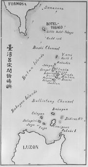
in a north south line across the Luzon Strait
Luzon Strait
The Luzon Strait is the strait between the island country of Taiwan and Luzon island of the Philippines. The strait thereby connects the Philippine Sea to the South China Sea in the western Pacific Ocean....
from Taiwan
Taiwan
Taiwan , also known, especially in the past, as Formosa , is the largest island of the same-named island group of East Asia in the western Pacific Ocean and located off the southeastern coast of mainland China. The island forms over 99% of the current territory of the Republic of China following...
to Luzon
Luzon
Luzon is the largest island in the Philippines. It is located in the northernmost region of the archipelago, and is also the name for one of the three primary island groups in the country centered on the Island of Luzon...
. It is the northern extension of the Philippine Mobile Belt
Philippine Mobile Belt
The Philippine Mobile Belt is a complex portion of the tectonic boundary between the Eurasian Plate and the Philippine Sea Plate, comprising most of the country of the Philippines. It includes two subduction zones, the Manila Trench to the west and the Philippine Trench to the east, as well as the...
. It is formed back from the western edge Philippine Sea Plate as it overrides the Yangtze Plate
Yangtze Plate
The Yangtze Plate, also called the South China Block or the South China Subplate, comprises the bulk of southern China. It is separated on the east from the Okinawa Plate by a rift that forms the Okinawa Trough which is a Back arc basin, on the south by the Sunda Plate and the Philippine Sea...
which is subducted in the Manila Trench
Manila Trench
The Manila Trench is an ocean trench in the South China Sea, west of the Philippines. It reaches a depth of about 5,400 m, in contrast with the average depth of the South China Sea of about 1,500 m...
.
Islands that form part of the arc are the Eastern Coastal Range of Taiwan
Taiwan
Taiwan , also known, especially in the past, as Formosa , is the largest island of the same-named island group of East Asia in the western Pacific Ocean and located off the southeastern coast of mainland China. The island forms over 99% of the current territory of the Republic of China following...
, Green Island, Taiwan
Green Island, Taiwan
Green Island is a small volcanic island in the Pacific Ocean, about off the eastern coast of Taiwan. In the 19th century it was known as Samasana Island and the Japanese called it Kasho-to . The island is 15.092 km² at high tide and 17.329 km² at low tide...
, Orchid Island
Orchid Island
Orchid Island is a 45-km² volcanic island off the southeastern coast of Taiwan island and separated from the Batanes of the Philippines by the Bashi Channel of the Luzon Strait. It is governed as Lanyu Township of Taitung County...
, Kaotai Rock, Mavudis or Y'ami Island, Mabudis, Siayan Island
Siayan Island
Siayan is one of the Batanes Islands of the Philippines. Also known as Ditarem Island in the native language, the island is about 1/2 mile to 3/4 miles in diameter and lies about 5 miles north-northeastward of Itbayat Island. The closest island is Mabudis Island which is about 1 miles...
, Itbayat Island
Itbayat Island
Itbayat is one of the Batanes Islands of the Philippines. Together with some other islands it forms the municipality of Itbayat in Batanes Province....
, Diogo Island
Diogo Island
Diogo Island is an uninhabited volcanic island in the province of Batanes, the northernmost province in the Philippines. Also known as Dinem Island in the native language, Diogo is a lone rock rising out of the sea, with steep cliffs on every side, and dangerous currents make landing there...
, Batan Island
Batan Island
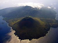
Batan island is the main island of the Batanes Province in the Philippines, part of the Batanes Islands group and the Luzon Volcanic Arc. It is home to the provincial capital Basco. The island is known chiefly for Mount Iraya....
, Unnamed volcano
Unnamed volcano (Ibugos)
Unnamed volcano , is a submarine volcano near the island Ibugos in the Philippines.-Location:The volcano is located 5 kilometres off Ibugos Island, one of the Batanes Islands, in the province of Batanes, in the Cagayan Valley Region, in the Philippines, within the Luzon Strait between Luzon and...
Ibuhos, Sabtang Island
Sabtang Island
Sabtang is an inactive volcanic island, one of the Batanes Islands of the Philippines. Together with some other islands it forms the municipality of Sabtang in Batanes Province.-External links:*...
, Babuyan, Didicas, Camiguin Island. At the south end it terminates on Luzon
Luzon
Luzon is the largest island in the Philippines. It is located in the northernmost region of the archipelago, and is also the name for one of the three primary island groups in the country centered on the Island of Luzon...
.


