

Lower South Providence, Providence, Rhode Island
Encyclopedia
Providence, Rhode Island
Providence is the capital and most populous city of Rhode Island and was one of the first cities established in the United States. Located in Providence County, it is the third largest city in the New England region...
, Rhode Island
Rhode Island
The state of Rhode Island and Providence Plantations, more commonly referred to as Rhode Island , is a state in the New England region of the United States. It is the smallest U.S. state by area...
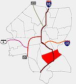
. It is bounded from Upper South Providence
Upper South Providence, Providence, Rhode Island
Upper South Providence is an official neighborhood in the South Side in the city of Providence, Rhode Island. It is bound to the north by Interstate 95, the east by the Providence River, to the south by Public Street, and the west by Broad Street...
by Public Street to the north, Interstate 95
Interstate 95 in Rhode Island
Interstate 95, the main north–south Interstate Highway on the east coast of the United States, runs generally southwest-northeast through the U.S. state of Rhode Island. It runs from the border with Connecticut near Westerly through Warwick and Providence and to the Massachusetts state line...
, to the south, and Broad Street, and the Providence River
Providence River
thumb|The city of Providence as seen from the Providence River at its confluence with the Narragansett BayThe Providence River is a tidal river in the U.S. state of Rhode Island. It flows approximately 8 miles...
to the west and east respectively. Though often associated closely with Upper South Providence, they are differentiated by location and the far more frequent occurrence in the latter of institutional buildings and space.
History
Originally the area that is now Lower South Providence was pasture land. The area was ceded to the new town of CranstonCranston, Rhode Island
Cranston, once known as Pawtuxet, is a city in Providence County, Rhode Island, United States. With a population of 80,387 at the 2010 census, it is the third largest city in the state. The center of population of Rhode Island is located in Cranston...
in 1754 and would not rejoin Providence until 1868.
A streetcar added in 1865 ran west along Public Street, and then south down Ocean Street, and would transform the Lower South Side into Providence's first streetcar suburb
Streetcar suburb
A streetcar suburb is a residential community whose growth and development was strongly shaped by the use of streetcar lines as a primary means of transportation. Early suburbs were served by horsecars, but by the late 19th century cable cars and electric streetcars, or trams, were used, allowing...
. In the next ten years, the streets along which the streetcar ran developed quickly.
Between 1860 and 1880, as the population of Providence doubled to 104,857, Irish immigrants, which had hitherto been confined further north, began to populate the southern part of Lower South Providence. Because the city of Cranston was traditionally Republican, residents began to fear that a large immigrant population, which overwhelmingly voted Democratic, would undermine its Republican political affiliations. For this reason, Cranston ceded the Lower South Side (along with Washington Park) back to Providence in 1868.
While the Upper South Side attracted industry for its proximity to downtown, the Lower South Side had greater access to Narragansett Bay
Narragansett Bay
Narragansett Bay is a bay and estuary on the north side of Rhode Island Sound. Covering 147 mi2 , the Bay forms New England's largest estuary, which functions as an expansive natural harbor, and includes a small archipelago...
and freight lines via the Port of Providence. Metal and jewelry factories appeared. Since factory owners and workers both lived near work, these operations encourage class mixture, which is reflected in the area's architectural stock. By the 1870s, fewer and grander single-family houses appeared, and the majority of housing became rented duplexes, rented by working class tenants.
By 1900, the large amount of housing construction and creation of new electrified rail lines, gave the area fast transportation and ample affordable housing, and the Lower South Side thrived. Between 1900 and 1950, now second and third-generation immigrants moved into newer, more affluent areas, with the increased prosperity they'd attained, depriving the region of its middle class. In 1943, the Roger Williams Housing Project was created, and though it was successful for the first 15 years, cuts in funding ultimately resulted in the most of the project's buildings being demolished.
After 1950, the automobile sentenced the area to a long inexorable decline. The creation of Interstate 95 under the Eisenhower Interstate System
Interstate Highway System
The Dwight D. Eisenhower National System of Interstate and Defense Highways, , is a network of limited-access roads including freeways, highways, and expressways forming part of the National Highway System of the United States of America...
required demolition of existing buildings and severed the region's historical connection to the waterfront. Green space was lost as lots and yards were converted into driveways and garages. Street renovation resulted in the loss of hitherto tree-lined streetscapes. Tenants owning cars began to look further out for newer, more prosperous neighborhoods.
As absentee landlords carved up single-family residences into multi-family dwellings, proper maintenance often neglected. Speculative purchases in the 1980s led many landlords in debt, raising rent, and further neglecting their properties.
Demographics
As of 1990, over half (54.1%) of Lower South Providence's residents were African-American, one in three was Hispanics, and roughly one in five was white. Four percent was Asian, and another 3.3 percent were Native American. More than four in ten residents did not speak fluent English, and less than half of the population under the age of 25 had completed high school. Unemployment was 20 percent compared with the city-wide average of 9.2 percent. Roughly one in three jobs were in manufacturing and another one in three were in professional services, accounting for the largest share of jobs.Median family income was $18,867, and 30.1% of families lived below the poverty line, an improvement from 40.4% in 1980.