

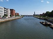
Providence River
Encyclopedia

Tidal river
A tidal river is a river, or more typically a stretch of a river, whose flow and level is influenced by tides. An example of a tidal river is the portion of the Connecticut River flowing from Windsor Locks, Connecticut, to the Atlantic Ocean. The Brisbane River, which flows into the Pacific Ocean...
in the U.S. state of Rhode Island
Rhode Island
The state of Rhode Island and Providence Plantations, more commonly referred to as Rhode Island , is a state in the New England region of the United States. It is the smallest U.S. state by area...
. It flows approximately 8 miles (13 km). There are no dams along the river's length, although the Fox Point Hurricane Barrier
Fox Point Hurricane Barrier
The Fox Point Hurricane Barrier is a long tidal flood barrier spanning the Providence River in Providence, Rhode Island, located upstream from Fox Point...
is located south of downtown, to protect the city of Providence
Providence, Rhode Island
Providence is the capital and most populous city of Rhode Island and was one of the first cities established in the United States. Located in Providence County, it is the third largest city in the New England region...
from damaging tidal floods.
The southern part of the river has been dredged at a cost of $65 million in federal and state funds to benefit nearby marinas and commercial shipping interests.
Owing to Adriaen Block
Adriaen Block
Adriaen Block was a Dutch private trader and navigator who is best known for exploring the coastal and river valley areas between present-day New Jersey and Massachusetts during four voyages from 1611 to 1614, following the 1609 expedition by Henry Hudson...
's exploration of Narragansett Bay, the Providence River (which the Dutch called the Nassau River) was the northeastern limit of Dutch claims in the colonial era from 1614 until the Hartford Treaty of 1650 and can therefore be regarded as the original boundary between the English New England
New England
New England is a region in the northeastern corner of the United States consisting of the six states of Maine, New Hampshire, Vermont, Massachusetts, Rhode Island, and Connecticut...
colonies and the Dutch colony of New Netherland
New Netherland
New Netherland, or Nieuw-Nederland in Dutch, was the 17th-century colonial province of the Republic of the Seven United Netherlands on the East Coast of North America. The claimed territories were the lands from the Delmarva Peninsula to extreme southwestern Cape Cod...
.
Course
The river is formed by the confluence of the WoonasquatucketWoonasquatucket River
The Woonasquatucket River is a river in the U.S. state of Rhode Island. It flows approximately and drains a watershed of 130 km² ....
and Moshassuck
Moshassuck River
The Moshassuck River is a river in the U.S. state of Rhode Island. It flows from the town of Lincoln to the city of Providence. There are six dams along the river's length.- History :...
rivers in downtown Providence. One half mile downstream, it is joined from the east by the Seekonk River
Seekonk River
The Seekonk River is a tidal extension of the Providence River in the U.S. state of Rhode Island. It flows approximately 8 km . Most historical scholars agree that the name is derived from two Native American words, sucki and honc...
and continues south. The cities of Providence, Cranston
Cranston, Rhode Island
Cranston, once known as Pawtuxet, is a city in Providence County, Rhode Island, United States. With a population of 80,387 at the 2010 census, it is the third largest city in the state. The center of population of Rhode Island is located in Cranston...
, and Warwick
Warwick, Rhode Island
Warwick is a city in Kent County, Rhode Island, United States. It is the second largest city in the state, with a population of 82,672 at the 2010 census. Its mayor has been Scott Avedisian since 2000...
lie to the west of the river, while the city of East Providence
East Providence, Rhode Island
East Providence is a city in Providence County, Rhode Island, United States. The population was 47,037 at the 2010 census, making it the fifth largest city in the state.-Geography:East Providence is located at ....
and the town of Barrington
Barrington, Rhode Island
Barrington is a town in Bristol County, Rhode Island, United States. The population was 16,310 at the 2010 census.In July 2005, CNN/Money and Money magazine ranked Barrington sixth on its list of the 100 best places to live in the United States.-History:...
lie to the east. At the narrows between Conimicut Point, in Warwick to the west and Nayatt Point in Barrington to the east, the Conimicut Shoal Lighthouse (http://www.lighthouse.cc/conimicut/) marks the entrance to the river from Narragansett Bay
Narragansett Bay
Narragansett Bay is a bay and estuary on the north side of Rhode Island Sound. Covering 147 mi2 , the Bay forms New England's largest estuary, which functions as an expansive natural harbor, and includes a small archipelago...
.
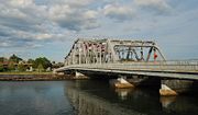
Crossings
Below is a list of all crossings over the Providence River. The list starts at the headwaters and goes downstream.- Providence
- Washington Place
- College Street
- Crawford Street
- Interstate 195Interstate 195 (Rhode Island-Massachusetts)Interstate 195 is an Interstate Highway running a combined 40.1 miles in the U.S. states of Massachusetts and Rhode Island. It travels from a junction with Interstate 95 in Providence, Rhode Island east to a junction with Interstate 495 and Route 25 in Wareham, Massachusetts...
- Point Street
- Fox Point Hurricane BarrierFox Point Hurricane BarrierThe Fox Point Hurricane Barrier is a long tidal flood barrier spanning the Providence River in Providence, Rhode Island, located upstream from Fox Point...
- Providence River Bridge (relocated Interstate 195)
Tributaries
- Seekonk RiverSeekonk RiverThe Seekonk River is a tidal extension of the Providence River in the U.S. state of Rhode Island. It flows approximately 8 km . Most historical scholars agree that the name is derived from two Native American words, sucki and honc...
- Pawtuxet RiverPawtuxet RiverThe Pawtuxet River is a river in the U.S. state of Rhode Island. It flows and drains a watershed of . There are four dams along the river's length.-Course:...
- Moshassuck RiverMoshassuck RiverThe Moshassuck River is a river in the U.S. state of Rhode Island. It flows from the town of Lincoln to the city of Providence. There are six dams along the river's length.- History :...
- Woonasquatucket RiverWoonasquatucket RiverThe Woonasquatucket River is a river in the U.S. state of Rhode Island. It flows approximately and drains a watershed of 130 km² ....
See also
- Providence, Rhode IslandProvidence, Rhode IslandProvidence is the capital and most populous city of Rhode Island and was one of the first cities established in the United States. Located in Providence County, it is the third largest city in the New England region...
- List of rivers in Rhode Island
- Moshassuck RiverMoshassuck RiverThe Moshassuck River is a river in the U.S. state of Rhode Island. It flows from the town of Lincoln to the city of Providence. There are six dams along the river's length.- History :...
- Pawtuxet RiverPawtuxet RiverThe Pawtuxet River is a river in the U.S. state of Rhode Island. It flows and drains a watershed of . There are four dams along the river's length.-Course:...
- Seekonk RiverSeekonk RiverThe Seekonk River is a tidal extension of the Providence River in the U.S. state of Rhode Island. It flows approximately 8 km . Most historical scholars agree that the name is derived from two Native American words, sucki and honc...
- Warren RiverWarren RiverThe Warren River is a tidal extension of the Palmer River in the U.S. state of Rhode Island. It flows approximately 6.5 km . There are no dams along the river's length.-Course:...
- Woonasquatucket RiverWoonasquatucket RiverThe Woonasquatucket River is a river in the U.S. state of Rhode Island. It flows approximately and drains a watershed of 130 km² ....
- Narragansett BayNarragansett BayNarragansett Bay is a bay and estuary on the north side of Rhode Island Sound. Covering 147 mi2 , the Bay forms New England's largest estuary, which functions as an expansive natural harbor, and includes a small archipelago...