
Louhajang River
Encyclopedia
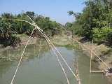
Louhajang River is located in central Bangladesh
. It branches out from the Jamuna at Baisnabbari in Tangail District
. Thereafter it splits into two parts before the parts meet up again. It flows past Tangail town, Karotia and Jamurki before joining the Bangshi
Louhajang is linked with the Dhaleshwari
The average depth is 3 foot (0.9144 m) and maximum depth is 9 feet (2.7 m).
Until around the 80s, launches and big boats carrying merchandise used to anchor at Tangail. A road at College Para in the town was named 'Amghat' as mangoes from Rajshahi were unloaded there. Besides, the river linked shoals in the western part with rest of the district. The river started dying after the Water Development Board constructed a sluice gate near the confluence of Louhajang and Dhaleshwari rivers in 1992 under its Flood Action Plan-20. Boats stopped plying the route since then as the river lost navigability. In the subsequent years, encroachment of its banks and shore areas increased.
Bangladesh
Bangladesh , officially the People's Republic of Bangladesh is a sovereign state located in South Asia. It is bordered by India on all sides except for a small border with Burma to the far southeast and by the Bay of Bengal to the south...
. It branches out from the Jamuna at Baisnabbari in Tangail District
Tangail District
Tangail is a district in central region of Bangladesh. It is a part of the Dhaka division. The population of Tangail zilla is about 3.2 million and its surface area is 3,414.39 km². The main town of Tangail District is the district town Tangail...
. Thereafter it splits into two parts before the parts meet up again. It flows past Tangail town, Karotia and Jamurki before joining the Bangshi
Bangshi River
Bangshi River is an important river in central Bangladesh. It originates in Jamalpur, from the course of the old Brahmaputra and flows past the Madhupur tract. It flows through Tangail and meets the Tongi in Ghazipur. It passes near Jatiyo Smriti Soudho in Savar and falls into the Dhaleshwari...
Louhajang is linked with the Dhaleshwari
Dhaleshwari River
The Dhaleshwari River is a 160-km-long distributary of the Jamuna River in central Bangladesh. It starts off the Jamuna near the northwestern tip of Tangail District. After that it divides into two branches: the north branch retains the name Dhaleshwari and merges with the other branch, the...
The average depth is 3 foot (0.9144 m) and maximum depth is 9 feet (2.7 m).
Until around the 80s, launches and big boats carrying merchandise used to anchor at Tangail. A road at College Para in the town was named 'Amghat' as mangoes from Rajshahi were unloaded there. Besides, the river linked shoals in the western part with rest of the district. The river started dying after the Water Development Board constructed a sluice gate near the confluence of Louhajang and Dhaleshwari rivers in 1992 under its Flood Action Plan-20. Boats stopped plying the route since then as the river lost navigability. In the subsequent years, encroachment of its banks and shore areas increased.