

Long Stratton
Encyclopedia
Long Stratton is a civil parish in South Norfolk
, in the East of England, UK
. It consists of two villages; the larger, Stratton St. Mary, is to the south, and the other, Stratton St. Michael, is to the north. It is home to a substantial population
of 3,701 (Census 2001
).
and the market town of Diss
; along the Roman
built road, the A140
(once known as Pye Road
) - which runs from Cromer
(North Norfolk
) to Ipswich
(Suffolk
).
Long Stratton borders five other parishes: Tharston and Hapton
, Tasburgh
, Morning Thorpe
, Pulham Market
, Wacton
.
.
, Long Stratton CP is home to 3,701 people, who reside in a total of 1,598 dwellings, and have a mean age of 38.63.
The statistics further confirm that Long Stratton is used as a commuter village, with the average employed person traveling 17.25 miles to their place of work.
around Long Stratton for over 60 years. Builders of the new "Churchfields" housing estate to the east of the village proposed to build a bypass as part of the submission for planning permission in the mid-1990s, though this was rejected by the Highways Agency on the grounds that the planned road was not of a sufficiently high standard to redesignate it as part of the main A140
Trunk Road
.
2006 was supposed to bring about the construction of the new bypass by Norfolk County Council, who had assumed responsibility for the A140
from the Highways Agency in 2001.
There was considerable opposition to the bypass on either side of the A140
, by residents of the village of Tharston to the west, and those of the hamlet of Wood Green Common to the east. Eventually, it was decided that a bypass to the east would have less environmental impact.
The total cost of the three miles stretch of dual carriageway
, with a roundabout at either end, was estimated to be £21.8m (2004) - compared to earlier estimates of £6m to £16m (2002).
Following the May 2005 elections, the planning suffered a one year delay, when changes to the planning permission
laws meant that the application for the permission of the bypass had to be resubmitted.
Subsequent changes to the way in which local road building projects are prioritised and funded have led to a decision to suspend construction of the bypass until 2016 at the earliest, despite Norfolk County Council already having spent over £1m on site preparation & legal fees. This led local resident Jason Bunn to establish an online petition on the Prime Minister's website calling for the funding to be made available immediately. Local MP Richard Bacon
also joined in the campaign, lobbying Transport Secretary Alistair Darling
and Roads Minister Stephen Ladyman
for a change in the decision.

 The village accommodates three schools first known as: Manor Field First School, St. Mary's Middle School, and Long Stratton High School. However, in September 2006, 'Manor Field First school' became 'Manor Field Infant school' and 'St. Mary's middle school' became 'St. Mary's church of England junior school'. Shops are located in two small shopping centres (South Norfolk Shopping Precinct and The Icehouse Precinct - so called because it was built adjacent to the Victorian icehouse belonging to Long Stratton Manor) as well as along the main street. Recently, a Co-op has been built in the centre of the village (see right) as well as a new Doctors Surgery, a bead shop, a book shop and lots of takeaways and hairdressers.
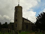
Long Stratton has two Church of England
churches (St Mary and St Michael), as well as a Methodist church. The church of Long Stratton St Mary (see right) is one of 124 existing round-tower church
es in Norfolk
.
The village has also seen the creation of two new housing estates for the new millennium, increasing the village population and size.
South Norfolk
South Norfolk is a local government district in Norfolk, England. Its council is based in Long Stratton.-History:The district was formed on April 1, 1974, under the Local Government Act 1972, as a merger of Diss Urban District, Wymondham Urban District, Depwade Rural District, Forehoe and Henstead...
, in the East of England, UK
United Kingdom
The United Kingdom of Great Britain and Northern IrelandIn the United Kingdom and Dependencies, other languages have been officially recognised as legitimate autochthonous languages under the European Charter for Regional or Minority Languages...
. It consists of two villages; the larger, Stratton St. Mary, is to the south, and the other, Stratton St. Michael, is to the north. It is home to a substantial population
Population
A population is all the organisms that both belong to the same group or species and live in the same geographical area. The area that is used to define a sexual population is such that inter-breeding is possible between any pair within the area and more probable than cross-breeding with individuals...
of 3,701 (Census 2001
Demographics of England from the 2001 United Kingdom census
The demography of England has since 1801 been measured by the decennial national census, and is marked by centuries of population growth and urbanisation...
).
Location
The village is situated half-way between the regional capital, NorwichNorwich
Norwich is a city in England. It is the regional administrative centre and county town of Norfolk. During the 11th century, Norwich was the largest city in England after London, and one of the most important places in the kingdom...
and the market town of Diss
Diss
Diss is a town in Norfolk, England close to the border with the neighbouring East Anglian county of Suffolk.The town lies in the valley of the River Waveney, around a mere that covers . The mere is up to deep, although there is another of mud, making it one of the deepest natural inland lakes...
; along the Roman
Roman Britain
Roman Britain was the part of the island of Great Britain controlled by the Roman Empire from AD 43 until ca. AD 410.The Romans referred to the imperial province as Britannia, which eventually comprised all of the island of Great Britain south of the fluid frontier with Caledonia...
built road, the A140
A140 road
The A140 is an 'A-class' road in Norfolk and Suffolk, East Anglia, England partly following the route of the Roman Pye Road. It runs from the A14 near Needham Market to the A149 south of Cromer. It is of primary status for the entirety of its route. It is approximately 56 miles in length...
(once known as Pye Road
Pye Road
Pye Road is a Roman road running from Camulodunum to Venta Icenorum -Route:The road runs from Camulodunum to Venta Icenorum partly sharing a route with the A140 road.-References:...
) - which runs from Cromer
Cromer
Cromer is a coastal town and civil parish in north Norfolk, England. The local government authority is North Norfolk District Council, whose headquarters is in Holt Road in the town. The town is situated 23 miles north of the county town, Norwich, and is 4 miles east of Sheringham...
(North Norfolk
North Norfolk
North Norfolk is a local government district in Norfolk, United Kingdom. Its council is based in Cromer. The council headquarters can be found approximately out of the town of Cromer on the Holt Road.-History:...
) to Ipswich
Ipswich
Ipswich is a large town and a non-metropolitan district. It is the county town of Suffolk, England. Ipswich is located on the estuary of the River Orwell...
(Suffolk
Suffolk
Suffolk is a non-metropolitan county of historic origin in East Anglia, England. It has borders with Norfolk to the north, Cambridgeshire to the west and Essex to the south. The North Sea lies to the east...
).
Long Stratton borders five other parishes: Tharston and Hapton
Tharston and Hapton
The civil parish of Tharston and Hapton lies in the south of the county of Norfolk, England. It encompasses the two villages of Tharston and Hapton, covering a total area of . The parish had a population of 599 in 231 households as of the 2001 census....
, Tasburgh
Tasburgh
Tasburgh is a civil parish and a village in the south of Norfolk, England. The River Tas flows nearby and Tasburgh Hall lies to the west of the village. The local church is dedicated to St...
, Morning Thorpe
Morning Thorpe
Morningthorpe is a village and civil parish in the English county of Norfolk. It is situated some south of the city of Norwich. Besides the village of Morningthorpe itself, the parish also includes the village of Fritton. The two villages are 1 km apart.The civil parish has an area of and in...
, Pulham Market
Pulham Market
Pulham Market and its sister village Pulham St Mary are situated approximately 9 miles north of Diss in Norfolk, England. It covers an area of and had a population of 999 in 443 households as of the 2001 census....
, Wacton
Wacton, Norfolk
Wacton is a village in the English county of Norfolk. It is located about one mile south-west of Long Stratton. It covers an area of and had a population of 319 in 128 households as of the 2001 census....
.
History
One of the ancient parishes that make up the modern village of Long Stratton was served by St Michael's church, whose rector from 1779 to 1823, Francis Wickham Swanton, was an Oxford contemporary of the celebrated Parson James WoodfordeJames Woodforde
James Woodforde was an English clergyman, best known as the author of The Diary of a Country Parson.-Early life:James Woodforde was born at the Parsonage, Ansford, Somerset, England on 27 June 1740...
.
Village Demographics
According to the 2001 United Kingdom CensusDemographics of England from the 2001 United Kingdom census
The demography of England has since 1801 been measured by the decennial national census, and is marked by centuries of population growth and urbanisation...
, Long Stratton CP is home to 3,701 people, who reside in a total of 1,598 dwellings, and have a mean age of 38.63.
The statistics further confirm that Long Stratton is used as a commuter village, with the average employed person traveling 17.25 miles to their place of work.
Bypass proposals
There has been cause for the building of a bypassBypass (road)
A bypass is a road or highway that avoids or "bypasses" a built-up area, town, or village, to let through traffic flow without interference from local traffic, to reduce congestion in the built-up area, and to improve road safety....
around Long Stratton for over 60 years. Builders of the new "Churchfields" housing estate to the east of the village proposed to build a bypass as part of the submission for planning permission in the mid-1990s, though this was rejected by the Highways Agency on the grounds that the planned road was not of a sufficiently high standard to redesignate it as part of the main A140
A140 road
The A140 is an 'A-class' road in Norfolk and Suffolk, East Anglia, England partly following the route of the Roman Pye Road. It runs from the A14 near Needham Market to the A149 south of Cromer. It is of primary status for the entirety of its route. It is approximately 56 miles in length...
Trunk Road
Trunk road
A trunk road, trunk highway, or strategic road is a major road—usually connecting two or more cities, ports, airports, and other things.—which is the recommended route for long-distance and freight traffic...
.
2006 was supposed to bring about the construction of the new bypass by Norfolk County Council, who had assumed responsibility for the A140
A140 road
The A140 is an 'A-class' road in Norfolk and Suffolk, East Anglia, England partly following the route of the Roman Pye Road. It runs from the A14 near Needham Market to the A149 south of Cromer. It is of primary status for the entirety of its route. It is approximately 56 miles in length...
from the Highways Agency in 2001.
There was considerable opposition to the bypass on either side of the A140
A140 road
The A140 is an 'A-class' road in Norfolk and Suffolk, East Anglia, England partly following the route of the Roman Pye Road. It runs from the A14 near Needham Market to the A149 south of Cromer. It is of primary status for the entirety of its route. It is approximately 56 miles in length...
, by residents of the village of Tharston to the west, and those of the hamlet of Wood Green Common to the east. Eventually, it was decided that a bypass to the east would have less environmental impact.
The total cost of the three miles stretch of dual carriageway
Dual carriageway
A dual carriageway is a class of highway with two carriageways for traffic travelling in opposite directions separated by a central reservation...
, with a roundabout at either end, was estimated to be £21.8m (2004) - compared to earlier estimates of £6m to £16m (2002).
Following the May 2005 elections, the planning suffered a one year delay, when changes to the planning permission
Planning permission
Planning permission or planning consent is the permission required in the United Kingdom in order to be allowed to build on land, or change the use of land or buildings. Within the UK the occupier of any land or building will need title to that land or building , but will also need "planning...
laws meant that the application for the permission of the bypass had to be resubmitted.
Subsequent changes to the way in which local road building projects are prioritised and funded have led to a decision to suspend construction of the bypass until 2016 at the earliest, despite Norfolk County Council already having spent over £1m on site preparation & legal fees. This led local resident Jason Bunn to establish an online petition on the Prime Minister's website calling for the funding to be made available immediately. Local MP Richard Bacon
Richard Bacon (politician)
Richard Michael Bacon is a British Conservative Party politician and the Member of Parliament for the South Norfolk constituency.-Early life:...
also joined in the campaign, lobbying Transport Secretary Alistair Darling
Alistair Darling
Alistair Maclean Darling is a Scottish Labour Party politician who has been a Member of Parliament since 1987, currently for Edinburgh South West. He served as the Chancellor of the Exchequer from 2007 to 2010...
and Roads Minister Stephen Ladyman
Stephen Ladyman
Stephen John Ladyman is a British Labour Party politician who was the Member of Parliament for South Thanet from 1997 until 2010.-Early life:...
for a change in the decision.
Facilities and amenities
Long Stratton has two Church of England
Church of England
The Church of England is the officially established Christian church in England and the Mother Church of the worldwide Anglican Communion. The church considers itself within the tradition of Western Christianity and dates its formal establishment principally to the mission to England by St...
churches (St Mary and St Michael), as well as a Methodist church. The church of Long Stratton St Mary (see right) is one of 124 existing round-tower church
Round-tower church
Round-tower churches are a type of church found mainly in England, almost solely in East Anglia; of about 185 surviving examples in the country, 124 are in Norfolk, 38 in Suffolk, 6 in Essex, 3 in Sussex and 2 each in Cambridgeshire and Berkshire. There is evidence of about twenty round-tower...
es in Norfolk
Norfolk
Norfolk is a low-lying county in the East of England. It has borders with Lincolnshire to the west, Cambridgeshire to the west and southwest and Suffolk to the south. Its northern and eastern boundaries are the North Sea coast and to the north-west the county is bordered by The Wash. The county...
.
The village has also seen the creation of two new housing estates for the new millennium, increasing the village population and size.
SNYA Radio
SNYA Radio is a community youth internet radio station run by and for young people in South Norfolk. Its studios are based at Long Stratton Leisure Centre.External links
- Website with photos of Long Stratton St Mary, a round-tower churchRound-tower churchRound-tower churches are a type of church found mainly in England, almost solely in East Anglia; of about 185 surviving examples in the country, 124 are in Norfolk, 38 in Suffolk, 6 in Essex, 3 in Sussex and 2 each in Cambridgeshire and Berkshire. There is evidence of about twenty round-tower...
- Diss Express - village's local newspaper website
- Information from Genuki Norfolk on Long Stratton.