
Llullaillaco National Park
Encyclopedia
Llullaillaco National Park is a national park of Chile
, located 275 km southeast of Antofagasta
in the Andes
. It lies between the eastern slopes of the Cordillera Domeyko
and the international border with Argentina
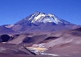
. In the park there are several important mountains that culminate at the summit of Llullaillaco
volcano. The park also is characterized by extensive semi-desert plains interspersed by Quebradas. A part of the Inca road system
is found in Río Frío area.
ecoregion
. In the park have been recorded 126 flora species, 21 of which are endemic to the area.
Herds of vicuña
s wander through the park.
Chile
Chile ,officially the Republic of Chile , is a country in South America occupying a long, narrow coastal strip between the Andes mountains to the east and the Pacific Ocean to the west. It borders Peru to the north, Bolivia to the northeast, Argentina to the east, and the Drake Passage in the far...
, located 275 km southeast of Antofagasta
Antofagasta
Antofagasta is a port city in northern Chile, about north of Santiago. It is the capital of Antofagasta Province and Antofagasta Region. According to the 2002 census, the city has a population of 296,905...
in the Andes
Andes
The Andes is the world's longest continental mountain range. It is a continual range of highlands along the western coast of South America. This range is about long, about to wide , and of an average height of about .Along its length, the Andes is split into several ranges, which are separated...
. It lies between the eastern slopes of the Cordillera Domeyko
Cordillera Domeyko
The Cordillera Domeyko is a mountain range of the Andes located in northern Chile, west of Salar de Atacama. It runs north-south for approximately 600 km, parallel to the main chain...
and the international border with Argentina
Argentina
Argentina , officially the Argentine Republic , is the second largest country in South America by land area, after Brazil. It is constituted as a federation of 23 provinces and an autonomous city, Buenos Aires...
. In the park there are several important mountains that culminate at the summit of Llullaillaco
Llullaillaco
Llullaillaco is a stratovolcano at the border of Argentina and Chile. It lies in the Puna de Atacama, a region of very high volcanic peaks on a high plateau within the Atacama Desert, one of the driest places in the world...
volcano. The park also is characterized by extensive semi-desert plains interspersed by Quebradas. A part of the Inca road system
Inca road system
The Inca road system was the most extensive and advanced transportation system in pre-Columbian South America. The network was based on two north-south roads with numerous branches. The best known portion of the road system is the Inca Trail to Machu Picchu...
is found in Río Frío area.
Vegetation
The park lies within the Central Andean dry punaCentral Andean dry puna
The Central Andean dry puna is an ecoregion, in the Montane grasslands and shrublands biome, located in the Andean High plateau, in South America...
ecoregion
Ecoregion
An ecoregion , sometimes called a bioregion, is an ecologically and geographically defined area that is smaller than an ecozone and larger than an ecosystem. Ecoregions cover relatively large areas of land or water, and contain characteristic, geographically distinct assemblages of natural...
. In the park have been recorded 126 flora species, 21 of which are endemic to the area.
Access
To access this area,the travel must be programmed and have official permission from the CONAF (National Forrest Guard of Chile) in Antofagasta City.Herds of vicuña
Vicuña
The vicuña or vicugna is one of two wild South American camelids, along with the guanaco, which live in the high alpine areas of the Andes. It is a relative of the llama, and is now believed to share a wild ancestor with domesticated alpacas, which are raised for their fibre...
s wander through the park.