
Llanyblodwel and Pant
Encyclopedia
| Llanyblodwel and Pant Ward | |
|---|---|
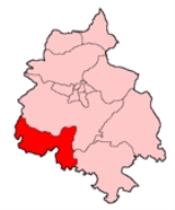
 Shown within the former Oswestry Borough Oswestry (borough) Oswestry was a small local government district with borough status in Shropshire, England. It was the smallest of the five districts of Shropshire in terms of both population and land area.... |
|
| Geography | |
| Status: | Electoral ward |
| Region Regions of England In England, the region is the highest tier of sub-national division used by central Government. Between 1994 and 2011, the nine regions had an administrative role in the implementation of UK Government policy, and as the areas covered by elected bodies... : |
West Midlands West Midlands (region) The West Midlands is an official region of England, covering the western half of the area traditionally known as the Midlands. It contains the second most populous British city, Birmingham, and the larger West Midlands conurbation, which includes the city of Wolverhampton and large towns of Dudley,... |
| County: | Shropshire Shropshire Shropshire is a county in the West Midlands region of England. For Eurostat purposes, the county is a NUTS 3 region and is one of four counties or unitary districts that comprise the "Shropshire and Staffordshire" NUTS 2 region. It borders Wales to the west... |
| District Non-metropolitan district Non-metropolitan districts, or colloquially shire districts, are a type of local government district in England. As created, they are sub-divisions of non-metropolitan counties in a so-called "two-tier" arrangement... : |
Oswestry Oswestry (borough) Oswestry was a small local government district with borough status in Shropshire, England. It was the smallest of the five districts of Shropshire in terms of both population and land area.... |
| Area Surface area Surface area is the measure of how much exposed area a solid object has, expressed in square units. Mathematical description of the surface area is considerably more involved than the definition of arc length of a curve. For polyhedra the surface area is the sum of the areas of its faces... : - Total |
25.95072 1 E7 m² To help compare sizes of different geographic regions, we list here areas between 10 km2 and 100 km2... km² |
| ONS code ONS coding system In the United Kingdom, the Office for National Statistics maintains a series of codes to represent a wide range of geographical areas of the UK, for use in tabulating census and other statistical data... : |
39UDFZ |
| Demographics | |
| Population Population A population is all the organisms that both belong to the same group or species and live in the same geographical area. The area that is used to define a sexual population is such that inter-breeding is possible between any pair within the area and more probable than cross-breeding with individuals... : - Total (2001) - Density Density The mass density or density of a material is defined as its mass per unit volume. The symbol most often used for density is ρ . In some cases , density is also defined as its weight per unit volume; although, this quantity is more properly called specific weight... |
2,317 89.29 / km² |
| Ethnicity: -(2001) |
98.6% White - British |
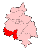
Llanyblodwel and Pant was a ward
Wards of the United Kingdom
A ward in the United Kingdom is an electoral district at sub-national level represented by one or more councillors. It is the primary unit of British administrative and electoral geography .-England:...
in the county of Shropshire
Shropshire
Shropshire is a county in the West Midlands region of England. For Eurostat purposes, the county is a NUTS 3 region and is one of four counties or unitary districts that comprise the "Shropshire and Staffordshire" NUTS 2 region. It borders Wales to the west...
.
Abolition
With the re-organisation of local government in Shropshire in 2009 (i.e. the abolition of the borough of Oswestry and the creation of a unitary Shropshire CouncilShropshire Council
Shropshire Council is a unitary authority in Shropshire, United Kingdom.It replaced the former two-tier local government structure in the non-metropolitan county of Shropshire on 1 April 2009, which involved its immediate predecessor, Shropshire County Council, and five non-metropolitan districts -...
) the ward was abolished and now forms part of a wider Llanymynech electoral division.
Geography
The ward covered the villages of PantPant, Shropshire
Pant is a village in Shropshire, England. It lies near the border with Wales. Pant means 'hollow' in Welsh: it is directly below the disused mines at Llanymynech Rocks Nature Reserve....
, Llynclys
Llynclys
Llynclys is a small village in Shropshire, England, in the civil parish of Llanyblodwel. It lies north of Pant at the crossroads of the A483 and B4396, where there are several houses and a pub, the White Lion....
, Porth-y-waen and Llanyblodwel
Llanyblodwel
Llanyblodwel is a village and civil parish in Shropshire, England; the spelling "Llanyblodwell" was commonly used in the past, and the village was sometimes simply referred to as "Blodwell". It lies 7 miles west of the nearest town, Oswestry, in the valley of the River Tanat.The parish had a...
, as well as half of Nantmawr
Nantmawr
Nantmawr is a village in Shropshire, England. It is located about 8 km south west of Oswestry and close to the Welsh border. The Offa's Dyke Path runs through the village....
and the English half of Llanymynech
Llanymynech
Llanymynech is a village straddling the border between Montgomeryshire/Powys, Wales and Shropshire, England about 9 miles north of the Welsh town of Welshpool. The name is Welsh for "Church of the Monks"....
, and contained the two parishes of Llanyblodwel
Llanyblodwel
Llanyblodwel is a village and civil parish in Shropshire, England; the spelling "Llanyblodwell" was commonly used in the past, and the village was sometimes simply referred to as "Blodwell". It lies 7 miles west of the nearest town, Oswestry, in the valley of the River Tanat.The parish had a...
and Llanymynech and Pant
Llanymynech and Pant
Llanymynech and Pant is a civil parish in Shropshire, England. The population of the parish is approximately 2,100.The two main villages within the parish are Llanymynech and Pant, though only the English half of Llanymynech is in the parish as the other half is in Powys, Wales.The parish is home...
. Despite being in England, almost without exception the villages and other settlements are named in Welsh
Welsh language
Welsh is a member of the Brythonic branch of the Celtic languages spoken natively in Wales, by some along the Welsh border in England, and in Y Wladfa...
, a vestige of the area's history as part of neighbouring Wales
Wales
Wales is a country that is part of the United Kingdom and the island of Great Britain, bordered by England to its east and the Atlantic Ocean and Irish Sea to its west. It has a population of three million, and a total area of 20,779 km²...
.
The terrain varies from flat farming land at an elevation of roughly 60m to the east of Llanymynech in the south, to rugged hills in the west reaching an elevation of roughly 310m to the north of Bryn.