
Llactapata
Encyclopedia
Llactapata is a combination of two Quechua words. The pronunciation of Llaqtapata is yakta-pahta.
Hiram Bingham
, discoverer of Machu Picchu and many other Incan sites, states that Llacta Pata is a descriptive term; "llacta" means "town" and "pata" means "a height". Thus, more than one site has been, and is, referred to by this name.
 A third site is also mentioned.
Hiram Bingham
first discovered Llactapata in 1912. "We found evidence that some Inca chieftain had built his home here and had included in the plan ten or a dozen buildings."
Bingham locates the site "on top of a ridge between the valleys of the Aobamba and the Salcantay, about 5,000 feet above the estate of Huaquina." "Here we discovered a number of ruins and two or three modern huts. The Indians said that the place was called Llacta Pata."
Bingham did not investigate the ruins thoroughly, however, and they were not studied again for another 70 years.
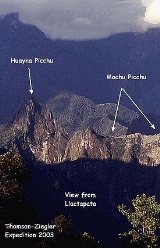
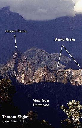
A mid-2003 study of the site conducted by Thomson and Ziegler concluded that Llactapata's location along the Inca trail suggested that it was an important rest stop and roadside shrine on the journey to Machu Picchu. The complex is located some four to five kilometers west of Machu Picchu high on a ridge between the Aobamba and Santa Teresa drainages. This and subsequent investigations have revealed an extensive complex of structures and features related to and connected with Machu Picchu by a continuation of the Inca Trail leading onward into the Vilcabamba. Llactapata may have been a member of the network of interrelated administrative and ceremonial sites which supported the regional center at Machu Picchu. It probably played an important astronomical function during the solstice
s and equinox
es.
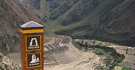
 Although the Llactapata to the east of Machu Picchu (at: 13.2325095°N 72.424922°W) is not the site referred to by Bingham as Llactapata it does appear to have acquired the common use name of Llactapata, as evidenced by the photograph of a sign from a check point along the Inca trail.
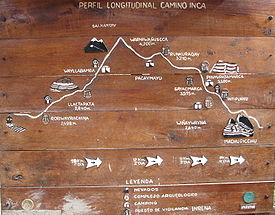
In addition to the site referred to in the section on Llactapata west, Bingham located another site "at Qquente, and near the mouth of the Pampaccahuana river, on top of a series of terraces". His associate Mr. Herman Tucker reported that the name of the town was Patallacta containing about one hundred houses. Above it were several important sites including Huayllabamba. This site is located 1.5 km (0.93205910497471 mi) from the start of the "Classic Inca Trail" which begins at Km 88.
 Patallacta and Llactapata east appear to be the same place.
This site housed a large number of occupants, including travellers and soldiers who manned the nearby "hill fort" of Willkaraqay. A shrine with rounded walls, known as Pulpituyoc, had religious and ceremonial functions.
Llactapata was burned by Manco Inca Yupanqui
, who destroyed a number of settlements along the Inca trail
during his retreat from Cusco
in 1536 to discourage Spanish pursuit. In part due to these efforts, the Spanish never discovered the Inca trail or any of its settlements.
Hiram Bingham
Hiram Bingham III
Hiram Bingham, formally Hiram Bingham III, was an academic, explorer, treasure hunter and politician from the United States. He made public the existence of the Quechua citadel of Machu Picchu in 1911 with the guidance of local indigenous farmers...
, discoverer of Machu Picchu and many other Incan sites, states that Llacta Pata is a descriptive term; "llacta" means "town" and "pata" means "a height". Thus, more than one site has been, and is, referred to by this name.
Sites associated with the name Llactapata
In the vicinity of Machu Picchu there appear to be two locations commonly referred to as Llactapata: one is a site about 5 km (3.1 mi) to the west of Machu Picchu; while the other is a site some 15 km (9.3 mi) to the south east of Machu Picchu. Both sites appear to be commonly known as Llactapata; both sites have Incan ruins; both sites are on different stretches of a trail known as the Inca trail.Llactapata west
The Llactapata to the west of Machu Picchu (at: 13.1756028°N 72.5859833°W) appears to be the site originally reported by Bingham as having this name. Although the site was little explored by Bingham, it was more extensively explored and mapped by the Thomson and Ziegler expedition of 2003.Hiram Bingham
Hiram Bingham III
Hiram Bingham, formally Hiram Bingham III, was an academic, explorer, treasure hunter and politician from the United States. He made public the existence of the Quechua citadel of Machu Picchu in 1911 with the guidance of local indigenous farmers...
first discovered Llactapata in 1912. "We found evidence that some Inca chieftain had built his home here and had included in the plan ten or a dozen buildings."
Bingham locates the site "on top of a ridge between the valleys of the Aobamba and the Salcantay, about 5,000 feet above the estate of Huaquina." "Here we discovered a number of ruins and two or three modern huts. The Indians said that the place was called Llacta Pata."
Bingham did not investigate the ruins thoroughly, however, and they were not studied again for another 70 years.
A mid-2003 study of the site conducted by Thomson and Ziegler concluded that Llactapata's location along the Inca trail suggested that it was an important rest stop and roadside shrine on the journey to Machu Picchu. The complex is located some four to five kilometers west of Machu Picchu high on a ridge between the Aobamba and Santa Teresa drainages. This and subsequent investigations have revealed an extensive complex of structures and features related to and connected with Machu Picchu by a continuation of the Inca Trail leading onward into the Vilcabamba. Llactapata may have been a member of the network of interrelated administrative and ceremonial sites which supported the regional center at Machu Picchu. It probably played an important astronomical function during the solstice
Solstice
A solstice is an astronomical event that happens twice each year when the Sun's apparent position in the sky, as viewed from Earth, reaches its northernmost or southernmost extremes...
s and equinox
Equinox
An equinox occurs twice a year, when the tilt of the Earth's axis is inclined neither away from nor towards the Sun, the center of the Sun being in the same plane as the Earth's equator...
es.
Lactapata east
In addition to the site referred to in the section on Llactapata west, Bingham located another site "at Qquente, and near the mouth of the Pampaccahuana river, on top of a series of terraces". His associate Mr. Herman Tucker reported that the name of the town was Patallacta containing about one hundred houses. Above it were several important sites including Huayllabamba. This site is located 1.5 km (0.93205910497471 mi) from the start of the "Classic Inca Trail" which begins at Km 88.
This site housed a large number of occupants, including travellers and soldiers who manned the nearby "hill fort" of Willkaraqay. A shrine with rounded walls, known as Pulpituyoc, had religious and ceremonial functions.
Llactapata was burned by Manco Inca Yupanqui
Manco Inca Yupanqui
Manco Inca Yupanqui was one of the Incas of Vilcabamba. He was also known as "Manco II" and "Manco Cápac II" . Born in 1516, he was one of the sons of Huayna Cápac and came from a lower class of the nobility.Túpac Huallpa, a puppet ruler crowned by conquistador Francisco Pizarro, died in 1533...
, who destroyed a number of settlements along the Inca trail
Inca road system
The Inca road system was the most extensive and advanced transportation system in pre-Columbian South America. The network was based on two north-south roads with numerous branches. The best known portion of the road system is the Inca Trail to Machu Picchu...
during his retreat from Cusco
Cusco
Cusco , often spelled Cuzco , is a city in southeastern Peru, near the Urubamba Valley of the Andes mountain range. It is the capital of the Cusco Region as well as the Cuzco Province. In 2007, the city had a population of 358,935 which was triple the figure of 20 years ago...
in 1536 to discourage Spanish pursuit. In part due to these efforts, the Spanish never discovered the Inca trail or any of its settlements.
A possible third site
A third site consisting of carved stone and buildings, Q'enqo, above Cuzco, may have been the death house of Pachakuti, called Chinchaysuyu or Patallacta.External Links
- Llactapata - a blog on Llactapata by Hugh Thomson
- an online version of 'Inca Land - Explorations in the Highlands of Peru' by Hiram Bingham