

List of volcanoes in Azores
Encyclopedia
Although there are no active volcanoes in the continental territory of Portugal, apart from geological remnants of ancient volcanism, the Portuguese Atlantic island possessions have a long history of active volcanism. The following is a list of active and extinct volcanoes in the Portuguese territories of the Azores
and Madeira
.
Azores
The Archipelago of the Azores is composed of nine volcanic islands situated in the middle of the North Atlantic Ocean, and is located about west from Lisbon and about east from the east coast of North America. The islands, and their economic exclusion zone, form the Autonomous Region of the...
and Madeira
Madeira
Madeira is a Portuguese archipelago that lies between and , just under 400 km north of Tenerife, Canary Islands, in the north Atlantic Ocean and an outermost region of the European Union...
.
Azores
| Name | Metres | Feet | Location | Island | Coordinate | Last eruption |
| Água de Pau (Fogo) | 947 | 947 metres (3,107 ft) | Serra de Água de Pau | São Miguel São Miguel Island São Miguel Island , nicknamed "The Green Island", is the largest and most populous island in the Portuguese Azores archipelago. The island covers and has around 140,000 inhabitants, 45,000 of these people located in the largest city in the archipelago: Ponta Delgada.-History:In 1427, São Miguel... |
||
| Caldeirão | 718 | 718 metres (2,355.6 ft) | Morro dos Homens Morro dos Homens Morro dos Homens is the highest mountain of Corvo Island, Azores, Portugal.... |
Corvo Corvo Island Corvo Island , literally the Island of the Crow, is the smallest and the northernmost island of the Azores archipelago and the northernmost in Macaronesia, with a population of approximately 468 inhabitants constituting the smallest single municipality in Azores and in Portugal.-History:A small... |
||
| - | ||||||
| Don Joao de Castro Bank | -43 | -43 m | Atlantic Ocean Atlantic Ocean The Atlantic Ocean is the second-largest of the world's oceanic divisions. With a total area of about , it covers approximately 20% of the Earth's surface and about 26% of its water surface area... |
|||
| 1720 | ||||||
| Sete Cidades | 856 | 856 metres (2,808.4 ft) | Sete Cidades Massif | São Miguel São Miguel Island São Miguel Island , nicknamed "The Green Island", is the largest and most populous island in the Portuguese Azores archipelago. The island covers and has around 140,000 inhabitants, 45,000 of these people located in the largest city in the archipelago: Ponta Delgada.-History:In 1427, São Miguel... |
||
| 1880 | ||||||
| Pico das Éguas | 874 | 874 metres (2,867.5 ft) | Sete Cidades Massif | São Miguel São Miguel Island São Miguel Island , nicknamed "The Green Island", is the largest and most populous island in the Portuguese Azores archipelago. The island covers and has around 140,000 inhabitants, 45,000 of these people located in the largest city in the archipelago: Ponta Delgada.-History:In 1427, São Miguel... |
||
| - | ||||||
| Serra Gorda | 485 | 485 metres (1,591.2 ft) | Picos Fissural Region | São Miguel São Miguel Island São Miguel Island , nicknamed "The Green Island", is the largest and most populous island in the Portuguese Azores archipelago. The island covers and has around 140,000 inhabitants, 45,000 of these people located in the largest city in the archipelago: Ponta Delgada.-History:In 1427, São Miguel... |
||
| - | ||||||
| Congro | 560 | 560 metres (1,837.3 ft) | Achada das Furnas | São Miguel São Miguel Island São Miguel Island , nicknamed "The Green Island", is the largest and most populous island in the Portuguese Azores archipelago. The island covers and has around 140,000 inhabitants, 45,000 of these people located in the largest city in the archipelago: Ponta Delgada.-History:In 1427, São Miguel... |
||
| -3400 | ||||||
| Furnas | 804 | 804 metres (2,637.8 ft) | Achada das Furnas | São Miguel São Miguel Island São Miguel Island , nicknamed "The Green Island", is the largest and most populous island in the Portuguese Azores archipelago. The island covers and has around 140,000 inhabitants, 45,000 of these people located in the largest city in the archipelago: Ponta Delgada.-History:In 1427, São Miguel... |
||
| 1630 | ||||||
| Santa Bárbara | 1021 | 1021 metres (3,349.7 ft) | Mistério Negros | Terceira Terceira Island Referred to as the “Ilha Lilás” , Terceira is an island in the Azores archipelago, in the middle of the North Atlantic Ocean. It is one of the larger islands of the archipelago, with a population of 56,000 inhabitants in an area of approximately 396.75 km²... |
||
| 1761 | ||||||
| Pico Alto | 808 | 808 metres (2,650.9 ft) | ||||
| Terceira Terceira Island Referred to as the “Ilha Lilás” , Terceira is an island in the Azores archipelago, in the middle of the North Atlantic Ocean. It is one of the larger islands of the archipelago, with a population of 56,000 inhabitants in an area of approximately 396.75 km²... |
||||||
| -1000 | ||||||
| Caldeira | 402 | 402 metres (1,318.9 ft) | ||||
| Graciosa | ||||||
| -10000 | ||||||
| Pico Mount Pico Mount Pico is a stratovolcano and the highest point on Pico Island in the Azores. It reaches an altitude of 2,351 meters above sea level, which makes it the highest point in Portugal and also in the Mid-Atlantic Ridge... |
2351 | 2351 metres (7,713.3 ft) | ||||
| Pico Pico Island Pico Island , is an island in the Central Group of the Portuguese Azores noted for its eponymous volcano, Ponta do Pico, which is the highest mountain in Portugal, the Azores, and the highest elevation of the Mid-Atlantic Ridge... |
||||||
| 1718 | ||||||
| Capelinhos | 755 | 755 metres (2,477 ft) | Costa de Nau | Faial Faial Island Faial Island , also known in English as Fayal, is a Portuguese island of the Central Group of the Azores.... |
||
| 1958 | ||||||
| Caldeira | 1043 | 1043 metres (3,421.9 ft) | Cabeço Gordo | Faial Faial Island Faial Island , also known in English as Fayal, is a Portuguese island of the Central Group of the Azores.... |
||
| 1958 | ||||||
| S.V. Serreta | 300 | 300 metres (984.3 ft) | Atlantic Ocean Atlantic Ocean The Atlantic Ocean is the second-largest of the world's oceanic divisions. With a total area of about , it covers approximately 20% of the Earth's surface and about 26% of its water surface area... |
|||
| 2001 | ||||||
| S.V. Velas | -32 | -32 m | Atlantic Ocean Atlantic Ocean The Atlantic Ocean is the second-largest of the world's oceanic divisions. With a total area of about , it covers approximately 20% of the Earth's surface and about 26% of its water surface area... |
|||
| 1964 | ||||||
| S.V. Cachorro | -130 | -130 m | Atlantic Ocean Atlantic Ocean The Atlantic Ocean is the second-largest of the world's oceanic divisions. With a total area of about , it covers approximately 20% of the Earth's surface and about 26% of its water surface area... |
|||
| 1963 | ||||||
| Monaco Bank | -197 | -197 m | Atlantic Ocean Atlantic Ocean The Atlantic Ocean is the second-largest of the world's oceanic divisions. With a total area of about , it covers approximately 20% of the Earth's surface and about 26% of its water surface area... |
|||
| S.V. Sabrina Sabrina Island (Azores) Sabrina Island was an islet formed during the months of June and July 1811 by a submarine volcanic eruption off Ponta da Ferraria, São Miguel Island, Azores, one of many that have been felt in the Sete Cidades Massif over time... |
-26 | -26 m | Atlantic Ocean Atlantic Ocean The Atlantic Ocean is the second-largest of the world's oceanic divisions. With a total area of about , it covers approximately 20% of the Earth's surface and about 26% of its water surface area... |
|||
| 1811 | ||||||
| Urzelina Urzelina (volcano) The Urzelina Volcano was a volcanic eruption that occurred in 1808, from a fissural cone along the island of São Jorge in the Azores, responsible for the destruction and deaths in the community of Urzelina, Velas, producing a basalt field of volcanic rock extending to the Ponta da Urzelina... |
900 | 900 metres (2,952.8 ft) | Mato da Urzelina | São Jorge | ||
| 1808 | ||||||
| Pico Vermelho | 937 | 937 metres (3,074.1 ft) | Fissural Zone | Terceira Terceira Island Referred to as the “Ilha Lilás” , Terceira is an island in the Azores archipelago, in the middle of the North Atlantic Ocean. It is one of the larger islands of the archipelago, with a population of 56,000 inhabitants in an area of approximately 396.75 km²... |
||
| 1761 | ||||||
| Cabeços do Fogo | 445 | 445 metres (1,460 ft) | Fissural Zone | Pico Pico Island Pico Island , is an island in the Central Group of the Portuguese Azores noted for its eponymous volcano, Ponta do Pico, which is the highest mountain in Portugal, the Azores, and the highest elevation of the Mid-Atlantic Ridge... |
||
| 1720 | ||||||
| S.V. Hirondella | -2665 | -2665 m | Atlantic Ocean Atlantic Ocean The Atlantic Ocean is the second-largest of the world's oceanic divisions. With a total area of about , it covers approximately 20% of the Earth's surface and about 26% of its water surface area... |
|||
| 1682 | ||||||
| Cabeço do Fogo | 104 | 104 metres (341.2 ft) | Capelo | Faial Faial Island Faial Island , also known in English as Fayal, is a Portuguese island of the Central Group of the Azores.... |
||
| 1672 | ||||||
| Picarito | 430 | 430 metres (1,410.8 ft) | Capelo | Faial Faial Island Faial Island , also known in English as Fayal, is a Portuguese island of the Central Group of the Azores.... |
||
| 1673 | ||||||
| Pico do Fogo | 275 | 275 metres (902.2 ft) | Fissural Zone | São Miguel São Miguel Island São Miguel Island , nicknamed "The Green Island", is the largest and most populous island in the Portuguese Azores archipelago. The island covers and has around 140,000 inhabitants, 45,000 of these people located in the largest city in the archipelago: Ponta Delgada.-History:In 1427, São Miguel... |
||
| 1652 | ||||||
| S.V. Candelária | -115 | -115 m | Ponta da Candelária | São Miguel São Miguel Island São Miguel Island , nicknamed "The Green Island", is the largest and most populous island in the Portuguese Azores archipelago. The island covers and has around 140,000 inhabitants, 45,000 of these people located in the largest city in the archipelago: Ponta Delgada.-History:In 1427, São Miguel... |
||
| 1638 | ||||||
| Lagoa Seca | 375 | 375 metres (1,230.3 ft) | Furnas | São Miguel São Miguel Island São Miguel Island , nicknamed "The Green Island", is the largest and most populous island in the Portuguese Azores archipelago. The island covers and has around 140,000 inhabitants, 45,000 of these people located in the largest city in the archipelago: Ponta Delgada.-History:In 1427, São Miguel... |
||
| 1630 | ||||||
| Mistério da Queimada | 264 | 264 metres (866.1 ft) | Fissual Zones Manadas | São Jorge | ||
| 1580 | ||||||
| Pico do Sapateiro (Pico Queimado) | 348 | 348 metres (1,141.7 ft) | Serra de Água de Paul | São Miguel São Miguel Island São Miguel Island , nicknamed "The Green Island", is the largest and most populous island in the Portuguese Azores archipelago. The island covers and has around 140,000 inhabitants, 45,000 of these people located in the largest city in the archipelago: Ponta Delgada.-History:In 1427, São Miguel... |
||
| 1563 | ||||||
| Cabeços do Mistério | 816 | 816 metres (2,677.2 ft) | Fissural Zone | Pico Pico Island Pico Island , is an island in the Central Group of the Portuguese Azores noted for its eponymous volcano, Ponta do Pico, which is the highest mountain in Portugal, the Azores, and the highest elevation of the Mid-Atlantic Ridge... |
||
| 1564 | ||||||
| Pico do Gaspar | 361 | 361 metres (1,184.4 ft) | Achada das Furnas | São Miguel São Miguel Island São Miguel Island , nicknamed "The Green Island", is the largest and most populous island in the Portuguese Azores archipelago. The island covers and has around 140,000 inhabitants, 45,000 of these people located in the largest city in the archipelago: Ponta Delgada.-History:In 1427, São Miguel... |
||
| 1443 |
Madeira
 |
| Name | Metres | Feet | Location | Island | Coordinate | Last eruption |
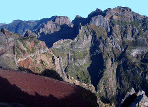
| Pico do Arieiro Pico do Arieiro Pico do Arieiro, at 1818 meters high , is the Madeira Island's third highest peak. The footpath northwards towards Pico Ruivo is an important tourist attraction, with a daily average of 1000 tourists trekking on it.... |
1818 | 1818 metres (5,964.6 ft) | Planalto da Madeira | Madeira Madeira Madeira is a Portuguese archipelago that lies between and , just under 400 km north of Tenerife, Canary Islands, in the north Atlantic Ocean and an outermost region of the European Union... |
||
| Pico Ruivo Pico Ruivo Pico Ruivo is the highest peak on the Madeira Islands. It can be reached only by foot, usually either from Pico do Arieiro after a strenuous hike, or from Achada do Teixeira with a shorter, easier trail. There is an additional trail leading west to Encumeada... |
1862 | 1862 metres (6,108.9 ft) | Planalto da Madeira | Madeira Madeira Madeira is a Portuguese archipelago that lies between and , just under 400 km north of Tenerife, Canary Islands, in the north Atlantic Ocean and an outermost region of the European Union... |
||
| Pico das Torres Pico das Torres Pico das Torres is the second highest peak on the island of Madeira. It lies roughly midway between the Pico Ruivo and Pico do Arieiro at an altitude of and is only accessible from the trail between these two peaks.... |
1853 | 1853 metres (6,079.4 ft) | Planalto da Madeira | Madeira Madeira Madeira is a Portuguese archipelago that lies between and , just under 400 km north of Tenerife, Canary Islands, in the north Atlantic Ocean and an outermost region of the European Union... |
||