
List of reservoirs and dams
Encyclopedia
The following is a list of reservoirs and dam
s, arranged by continent and country.
Dam
A dam is a barrier that impounds water or underground streams. Dams generally serve the primary purpose of retaining water, while other structures such as floodgates or levees are used to manage or prevent water flow into specific land regions. Hydropower and pumped-storage hydroelectricity are...
s, arranged by continent and country.
Ethiopia
- Gilgel Gibe I Dam
- Gilgel Gibe III Dam
- Kessem Dam
- Tendaho Irrigation Dam
- Tekeze Hydroelectric Dam
Kenya
- Gitaru Reservoir
- Kiambere Reservoir
- Kindaruma Reservoir
- Masinga Reservoir
- Nairobi DamNairobi DamThe Nairobi Dam is an embankment dam on the Nairobi River in Nairobi, Kenya.-Background:The Dam constructed in 1953 holds back a reservoir with storage capacity of and surface area of...
Morocco
- Aït Ouarda Dam
- Allal al Fassi DamAllal al Fassi DamThe Allal al Fassi Dam is a embankment dam located northeast of Sefrou on the Sebou River in the Fès-Boulemane region of Morocco. Completed in 1991, the dam provides water for irrigation and hydroelectric power production. The dam's hydroelectric power station is located to the north on the...
- Al Massira DamAl Massira DamThe Al Massira Dam is a gravity dam located south of Settat on the Oum Er-Rbia River in Settat Province, Morocco. Completed in 1979, the dam provides water for the irrigation of over of farmland in the Doukkala region. The dam's hydroelectric power plant also generates 221 GWh on average...
- Al Wahda DamAl Wahda Dam (Morocco)Al Wahda Dam, formerly known as M'Jaara Dam, is an embankment dam on the Ouergha River near M´Jaara in Sidi Kacem Province, Morocco. It was constructed for flood control, irrigation, water supply and hydroelectric power production. It is the second largest dam in Africa and the largest in Morocco...
- Bin el Ouidane DamBin el Ouidane DamThe Bin el Ouidane Dam is an arch dam located south of Beni Mellal on the El Abid River in Azilal Province, Morocco. Constructed between 1949 and 1953, the purpose of the dam is hydroelectric power production and irrigation. Its 135 MW power station produces an average of 287 GWh annually and...
- Daourat Dam
- Hassan I DamHassan I DamThe Hassan I Dam is an embankment dam located northeast of Demnate on the Lakhdar River in Azilal Province, Morocco. Completed in 1986, the dam provides water for the irrigation of over of farmland. The dam's hydroelectric power plant also generates 132 GWh on average annually. At in height, it...
- Hassan II Dam
- Idriss I Dam
- Imfout Dam
- Mohamed V DamMohamed V DamThe Mohamed V Dam is an arch-gravity dam located south of Zaio on the Moulouya River in Oujda-Angad Province, Morocco. The primary purpose of the dam is supplying water for the irrigation of downstream. Water is also used for hydroelectric power production and water supply to the city of Nador....
- Tanafnit El Borj Dam
- Youssef Ibn Tachfin Dam
Nigeria
- Asejire Dam, Oyo StateOyo StateỌyọ State is an inland state in south-western Nigeria, with its capital at Ibadan. It is bounded in the north by Kwara State, in the east by Osun State, in the south by Ogun State and in the west partly by Ogun State and partly by the Republic of Benin....
- Bakolori DamBakolori DamThe Bakolori Dam is in Sokoto State in the Northwest of Nigeria, completed in 1978 and its reservoir filled by 1981. It is a major reservoir on the Sokoto River, a tributary of the Rima River, which in turn feeds the Niger River...
, Sokoto StateSokoto StateSokoto State is located in the extreme northwest of Nigeria, near to the confluence of the Sokoto River and the Rima River. As of 2005 it has an estimated population of more than 4.2 million... - Challawa Gorge DamChallawa Gorge DamThe Challawa Gorge Dam is in Kano State in the Northeast of Nigeria, about 90 km southwest of Kano city. It is a major reservoir on the Challawa River, a tributary of the Kano River, which is the main tributary of the Hadejia River.-Construction:...
, Kano StateKano StateKano State is a state located in North-Western Nigeria. Created on May 27, 1967 from part of the Northern Region, Kano state borders Katsina State to the north-west, Jigawa State to the north-east, Bauchi State to the south-east and Kaduna State to the south-west... - Cham Dam, Gombe StateGombe StateGombe State, located in the northeastern part of Nigeria, is one of the country's 36 states; its capital is Gombe. The boundaries of the state roughly correspond to those of the Gombe Emirate,a traditional state.[2]...
- Dadin Kowa DamDadin Kowa DamThe Dadin Kowa Dam is in Yamaltu local government area of Gombe State in the north east of Nigeria.The dam is located about 35 kilometers to the east of Gombe town, and provides drinking water for the town...
, Gombe StateGombe StateGombe State, located in the northeastern part of Nigeria, is one of the country's 36 states; its capital is Gombe. The boundaries of the state roughly correspond to those of the Gombe Emirate,a traditional state.[2]... - Goronyo DamGoronyo DamThe Goronyo Dam impounds the Rima River in Goronyo local government area of Sokoto State in the north of Nigeria. It was completed in 1984 and commissioned in 1992...
, Sokoto StateSokoto StateSokoto State is located in the extreme northwest of Nigeria, near to the confluence of the Sokoto River and the Rima River. As of 2005 it has an estimated population of more than 4.2 million... - Gusau Dam, Zamfara StateZamfara StateZamfara State is a state in northwestern Nigeria. Its capital is Gusau and its Governor is Abdul'aziz Abubakar Yari, a member of the All Nigeria Peoples Party . Until 1996 the area was part of Sokoto State....
- Ikere Gorge DamIkere Gorge DamThe Ikere Gorge Dam is a major earth-fill dam in Iseyin local government area of Oyo State in the south west of Nigeria on the Ogun River.Reservoir capacity is 690 million m3....
, Oyo StateOyo StateỌyọ State is an inland state in south-western Nigeria, with its capital at Ibadan. It is bounded in the north by Kwara State, in the east by Osun State, in the south by Ogun State and in the west partly by Ogun State and partly by the Republic of Benin.... - Jibiya DamJibiya DamThe Jibiya Dam is in Jibiya local government area of Katsina State in the north of Nigeria. It is an earth-fill structure with a geomembrane liner, with a height of 23.5 m and a total length of 3,660 m, and has a capacity of 142 million m3....
, Katsina StateKatsina StateKatsina State is a state in northern Nigeria. Its capital is Katsina, and its governor is Ibrahim Shema, a member of the People's Democratic Party... - Jebba Dam, Kwara StateKwara StateKwara State is one of the 36 states of Nigeria. Its capital is Ilorin. The primary ethnic group of Kwara State is Yoruba, with significant Nupe, Bariba and Fulani minorities.- History :...
- Kafin Zaki DamKafin Zaki DamThe Kafin Zaki Dam is a controversial project to build a reservoir on the Jama'are River in Bauchi State in the Northeast of Nigeria.-Proposed dam and reservoir:...
, Bauchi StateBauchi StateBauchi State is a State in northern Nigeria. Its capital is the city of Bauchi. The state was formed in 1976 when the former North-Eastern State was broken up... - Kainji DamKainji DamKainji Dam is a dam across the Niger River in western Nigeria. Construction of the dam began in 1964 and was completed in 1968. The total cost was estimated at $209 million, with one-quarter of this amount used to resettle people displaced by the construction of the dam and its reservoir,...
, Niger StateNiger StateNiger State is a state in the western part of Nigeria and the largest state in the country. The state capital is Minna, and other major cities are Bida, Kontagora, and Suleja. It was formed in 1976 when the then North-Western State was bifurcated into Niger State and Sokoto State.The state is named... - Kiri DamKiri DamThe Kiri Dam is in Guyuk local government area of Adamawa State in the north east of Nigeria, damming the Gongola River.It is a 1.2 km long, 20 m high zoned embankment with an internal clay blanket.The dam was mainly completed in 1982....
, Adamawa StateAdamawa StateAdamawa is a state in northeastern Nigeria, with its capital at Yola. It was formed in 1991 from part of Gongola State with four administrative divisions namely: Adamawa, Ganye, Mubi and Numan. It is one of the thirty-six States which constitute the Federal Republic of Nigeria.-Geography:Adamawa... - Obudu DamObudu DamThe Obudu Dam is in Obudu local government area of Cross River State in the south east of Nigeria. It is an earth-fill structure with a height of 15 m and a total crest length of 425 m, and has a capacity of 4.2 million m3....
, Cross River StateCross River StateCross River State is a coastal state in southeastern Nigeria, bordering Cameroon to the east. Its capital is at Calabar, and it is named for the Cross River , which passes through the state... - Oyan Dam, Ogun StateOgun StateOgun State is a state in South-western Nigeria. It borders Lagos State to the South, Oyo and Osun states to the North, Ondo State to the east and the republic of Benin to the west. Abeokuta is the capital and largest city in the state...
- Shiroro Dam, Niger StateNiger StateNiger State is a state in the western part of Nigeria and the largest state in the country. The state capital is Minna, and other major cities are Bida, Kontagora, and Suleja. It was formed in 1976 when the then North-Western State was bifurcated into Niger State and Sokoto State.The state is named...
- Swashi Dam, Niger StateNiger StateNiger State is a state in the western part of Nigeria and the largest state in the country. The state capital is Minna, and other major cities are Bida, Kontagora, and Suleja. It was formed in 1976 when the then North-Western State was bifurcated into Niger State and Sokoto State.The state is named...
- Tiga DamTiga DamThe Tiga Dam is in Kano State in the Northeast of Nigeria, constructed in 1971-1974. It is a major reservoir on the Kano River, the main tributary of the Hadejia River. Water from the dam supplies the Kano River Irrigation Project as well as Kano City...
, Kano StateKano StateKano State is a state located in North-Western Nigeria. Created on May 27, 1967 from part of the Northern Region, Kano state borders Katsina State to the north-west, Jigawa State to the north-east, Bauchi State to the south-east and Kaduna State to the south-west... - Zobe DamZobe DamThe Zobe Dam is in Dutsin-Ma local government area of Katsina State in the north of Nigeria. It is an earth-fill structure with a height of 19 m and a total length of 2,750 m.The dam has a storage capacity of 179 Mca and irrigation potential of 8,000 hectares....
, Katsina StateKatsina StateKatsina State is a state in northern Nigeria. Its capital is Katsina, and its governor is Ibrahim Shema, a member of the People's Democratic Party...
Tanzania
- KidatuKidatuKidatu is a town in southern Tanzania located in Kilombero district, Morogoro Region. The local population is about 3300. Primary economic activity is the large Illovo sugar plantation.Kidatu is a town in central Tanzania...
- Kihansi DamKihansi DamKihansi Dam is a hydroelectric dam located on the Kihansi River at the end of the Kihansi Gorge before the convergence with the Ulanga River in Tanzania approximately 450 km southwest of the capital Dar Es Salaam.-Kihansi Dam:...
- Mtera DamMtera damMtera Dam is a hydroelectric dam in Tanzania. The dam is located midway between Iringa and Dodoma on the border between the Iringa Region and the Dodoma Region. The travel time from Dodoma is about three hours on a gravel road.-Overview:...
- Nyumba ya Mungu
- Hombolo DamHombolo DamHombolo Dam is a dam in Tanzania. It is at Hombolo-Bwawani village, in Dodoma-rural District. The dam was constructed by the colonial government in 1957 for irrigation, domestic water supply, and water for livestock.- Overview :...
Uganda
- Ayago Power StationAyago Power Station-Location:The Power Station will be located at Ayago , on the Victoria Nile, in Nwoya District. This location lies approximately , by road, south of Nwoya, the location of the district headquarters. This location is within the confines of Murchison Falls National Park...
- Bujagali Power StationBujagali Power Station-Location:The power station is located across the Victoria Nile, about north of Jinja immediately north of the former location of Bujagali Falls. This location lies at the border between Buikwe District to the west and Jinja District to the east...
- Isimba Power StationIsimba Power StationIsimba Power Station is a 140MW hydroelectric power project to be constructed in Uganda.-Location:The Power Station will be is located at the village of Isimba, on the Victoria Nile, in Kamuli District. The approximate coordinates of the power station are:0° 56' 24.00"N, 32° 57' 54.00"E...
- Karuma Power StationKaruma Power Station-Location:The Power Station will be located at Karuma, on the Victoria Nile, at the present location of the Karuma Falls. This location is adjacent to the location where the Masindi-Gulu Highway, crosses the river Nile. It is approximately , by road, northeast of Masindi and approximately , by...
- Kiira Power StationKiira Power StationKiira Power Station, sometimes spelled Kiyira Power Station, is a hydroelectric power station with an installed capacity of 200MW, in Uganda.-Location:...
- Nalubaale Power StationNalubaale Power StationNalubaale Power Station, often known by its old name, Owen Falls Dam, is a hydroelectric power station across the White Nile near to its source at Lake Victoria in Uganda...
Japan
- Hakusui DamHakusui Damthumb|Hakusui DamThe Hakusui Dam is a concrete gravity dam on the upper reaches of the Ōno River in Taketa, Ōita Prefecture, Japan. It was constructed in 1938 and is 86m wide and 14m tall....
, Oita - Hōnen'ike DamHonen'ike DamHōnen'ike Dam is a multiple-arch dam in the Sanuki Mountain range at Ōnohara, Kagawa Prefecture, Japan. The reservoir it creates is used for irrigation. Construction began in 1926 and was completed in 1930. The dam is 31 m high and has a crest length of 128 m. It is supported by six arched...
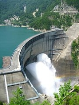
, Kagawa - Kurobe damKurobe damThe or , is a variable-radius arch dam on the Kurobe River in Toyama Prefecture on the island of Honshū, Japan. It supports the 335 MW Kurobe No. 4 Hydropower Plant and is owned by Kansai Electric Power Company. At high, it is the tallest dam in Japan. It was constructed between 1956 and 1963 at...
, Toyama. Japan's largest - Nibutani DamNibutani Damis a dam on the Saru River in Hokkaidō, Japan, which stands at Nibutani in Biratori town, Saru District. Work on the dam began in 1990. It was completed in March 1997, despite objections from the local Ainu people.-Controversy:...
, Hokkaido
Malaysia
- Air Itam Dam
- Babagon Dam
- Bakun Dam
- Batang Ai DamBatang Ai DamThe Batang Ai Dam is a concrete-faced rockfill hydroelectric dam in Batang Ai National Park in Sarawak, Malaysia. The power station comprises four turbines, totalling the installed capacity to . The station is operated by Sarawak Electricity Supply Corporation. Preparations for the dam began as...
- Beris Dam
- Batu DamBatu DamBatu Dam is one of the major dams of Klang Valley located in Selangor, Malaysia. The dam is a water supply dam. The dam holding capacity is 30,199 million litres. The Sungai Batu water treatment plant produces 114 million litres per day of treated water, 23.7 of which is used in industrial...
- Chenderoh Dam
- Kenyir Dam
- Klang Gates
- Mengkuang DamMengkuang DamMengkuang Dam is a Dam located less than 28 km to the north-east of Butterworth town. It is the only dam situated in Province Wellesley and the second dam built in Penang after Ayer Itam dam. It was officially opened by the former Governor, Dr. Tun Awang bin Hassan in 1985...
- Pedu LakePedu LakePedu Lake is a man made lake located in the State of Kedah, North Malaysia. Located about 5 km from Thailand, this huge lake covers an area of 75 km²....
- Pergau DamPergau DamPergau Dam is the hydroelectric dam in Kuala Yong, Kelantan, Malaysia. It is located about 100 km west of Kota Bharu.-Power station:The power station is a hydroelectric power station, using 4 turbines of 150 MW installed capacity...
- Teluk Bahang Dam
- Temenggor DamTemenggor DamThe Temenggor Dam or Temenggor Power Station is a dam in Gerik, Perak, Malaysia. It is located on Sungai Perak about 200 km northeast of Ipoh. Construction of the dam impounded Temenggor Lake.-Power station:...
Philippines
- Ambuklao DamAmbuklao DamAmbuklao Dam is a dam that supports a hydroelectric plant in the mountains of Bokod, Benguet province of Philippines. The development of the Agno River for purposes of hydroelectric power generation, flood control, and irrigation had been conceived as early as the late 1940s...
- Agusan DamAgusan DamThe Agusan Hydroelectric Plant, the downstream plant of two proposed plants, was constructed in Damilag, Manolo, Fortich, and Bukidnon to serve the immediate domestic and industrial requirements of the area. The watershed is small, and covers an area of around 25 km2 at the diversion dam...
- Angat DamAngat DamAngat Dam is a concrete water reservoir embankment hydroelectric dam that supplies the Manila metropolitan area water. It was a part of the Angat-Ipo-La Mesa water system...
- Binga DamBinga DamBinga Dam, or Binga Powerplant is a hydroelectric plant situated at Barrio Binga, Itogon, Benguet, Philippines. The plant was constructed in 1956 and was opened in 1960, three years after Ambuklao Dam was opened.-References:*...
- Caliraya DamCaliraya DamCaliraya Dam is an embankment dam located in the town of Lumban province of Laguna, in the Sierra Madre Mountain Range of the Philippines. The reservoir created by the dam, Lake Caliraya, initially supplied one of the oldest hydroelectric plants in the Philippines, and later became a popular...
- Calumpang Dam
- Ipo DamIpo DamIpo Dam is a gravity concrete water reservoir dam found in the Philippines. The dam is located about 7.5 kilometers downstream of the Angat Dam in Norzagaray, Bulacan province. It was a part of the Angat-Ipo-La Mesa water system.-References:*...
- La Mesa DamLa Mesa DamThe La Mesa Watershed and Eco-Park is a dam and an ecological reservation site in Quezon City commissioned in 1929 in the Philippines. It is part of the Angat-Ipo-La Mesa water system, which supplies most of the water supply of Metro Manila...
- Magat DamMagat DamMagat Dam is a large rock-fill dam on the island of Luzon in the Philippines. The dam is located on Magat River, a major tributary of Cagayan River. Construction of the dam started in 1975 and completed in 1982...
- Pantabangan DamPantabangan DamPantabangan Dam is an earth-fill embankment dam on the Pampanga River located near Pantabangan in Nueva Ecija province of the Philippines. The multi-purpose dam provides water for irrigation and hydroelectric power generation while its reservoir affords flood control. The reservoir is considered...
- San Roque DamSan Roque Dam (Philippines)The San Roque Dam, operated under San Roque Multipurpose Project is a massive gated spillway of 200 meters height, 1.2 kilometer length embankment dam on the Agno River spanning the municipalities of San Manuel and San Nicolas, Pangasinan, nearly 200 km north of Metro Manila.The dam impounds...
- Wawa Dam
Syria
- Baath DamBaath DamThe Baath Dam is a dam on the Euphrates, located upstream from the city of Ar-Raqqah in Ar-Raqqah Governorate, Syria. Construction of the dam started in 1983 and was finished in 1986. It is intended to generate hydroelectric power as well as regulate the irregular flow from the Tabqa Dam, which...
- Hassakeh East Dam
- Hassakeh South Dam
- Hassakeh West Dam
- Tabqa Dam
- Tishrin DamTishrin DamThe Tishrin Dam is a dam on the Euphrates, located east of Aleppo in Aleppo Governorate, Syria. The dam is high and has 6 water turbines capable of producing 630 MW. Construction lasted between 1991 and 1999...
Taiwan
- Feitsui DamFeitsui DamFeitsui or Feicuei Dam spans the Xindian River in northern Taiwan, southeast of the city of Taipei. It is one of two major reservoirs supplying water to the Taipei-Tamsui-Taoyuan region, the other being Shimen Dam to the west. The dam was built almost exclusively for municipal water supply,...
- Junghua DamJunghua DamJunghua Dam is a dam crossing the Dahan River, a tributary to the Tamsui River, in Fuxing, Taoyuan County, Taiwan.The dam was started in December 1978 and finished in June 1984. The cost was NT$1.83 billion....
- Mingte Dam
- Mingtan DamMingtan DamThe Mingtan Dam spans the Shuili River about downstream from the outlet of Sun Moon Lake in central Taiwan. About high, the dam was completed in 1990. It forms Minghu Reservoir which is the lower reservoir for the Minghu Pumped-Storage Project...
- Shimen DamShimen DamShimen Dam is an embankment dam crossing the Dahan River in Taoyuan County, Taiwan. Serving mainly for municipal water supply and flood control, the dam creates Shimen Reservoir in the mountains south of Longtan. The construction plan was created in 1938 under Japanese rule, but was not...
- Techi DamTechi DamThe Techi Dam is a concrete thin arch dam on the Dajia River in the mountains of central Taiwan, some south of Heping in Taichung County. At high, it is one of the tallest dams in the country. It serves primarily for flood control and hydroelectric generation...
- Wushantou Dam
- Zengwun DamZengwun DamZengwun Dam is a major earthen dam in southern Taiwan on the Zengwun River. It is one of the largest dams in the country and also forms the largest reservoir in Taiwan...
Austria
- Erlauf Dam
- Gepatsch Reservoir
- Kölnbrein Dam
- Schlegeis Reservoir
- Silvretta Dam
- Kaprun Dam
- Ottenstein Dam
- Lake Wienerwald
Finland
- Kemijärvi area 130–285 km² (regulated volume 1,067 million m³)
- Lokka reservoirLokka ReservoirThe Lokka Reservoir , is a reservoir, upstream of the Luiro River in Sodankylä, in northern Finland. Depending on the water level, its area ranges from 216 to 418 km². The corresponding water levels above mean sea level are 240–245 meters...
(Lokan tekojärvi) area 216–417 km² (regulated volume 1,444 million m³) - Porttipahta reservoirPorttipahta ReservoirPorttipahta Reservoir is a lake of Finland.-References:* *...
(Porttipahdan tekojärvi) area 34–214 km² (regulated volume 1,097 million m³)
Iceland
- BlöndulónBlöndulónAt 57 km², Blöndulón is one of Iceland's largest lakes. It was created in 1984-1991 as a reservoir for the Blönduvirkjun power plant, and has a greatest depth of 39 m. It is situated near Kjölur highland road in the Highlands of Iceland. The hot springs of Hveravellir are situated some...
- Kárahnjúkar Hydropower ProjectKárahnjúkar Hydropower ProjectKárahnjúkar Hydropower Plant is a hydroelectric power plant in eastern Iceland designed to produce 4,600 GWh annually for Alcoa's Fjardaál aluminum smelter to the east in Reyðarfjörður. The project, named after nearby Mount Kárahnjúkur, involves damming the Jökulsá á Dal River and the Jökulsá...
- SigöldulónSigöldulónThe lake Sigöldulón is a reservoir in Iceland, also known as Krókslón. Situated in the south of the country, not far from Landmannalaugar, it is one of the country's 20 largest lakes at 14 km²....
- ÞórisvatnÞórisvatnÞórisvatn, is the largest lake of Iceland, situated at the south end of Sprengisandur highland road within the highlands of Iceland.It is a reservoir of a surface about 88 km² and uses the energy of the river Þjórsá, which comes down from the glacier Hofsjökull. Here in the south, it is exploited...
Ireland
- Ardnacrusha
- Cathlene's Falls
- Cliff
- Golden falls
- Iniscara
- Leixlip lake
- Poulaphucca
Russia
- Chirkey Reservoir
- Chogray ReservoirChogray ReservoirChogray Reservoir is an artificial reservoir on the East Manych River on the border of Stavropol Krai and Kalmykia in southern Russia.The reservoir, 49 km long, was constructed in 1969-1973, primarily to satisfy the demands of local irrigated farming....
- Gorky ReservoirGorky ReservoirGorky Reservoir is an artificial lake in the central part of the Volga River formed by a hydroelectric dam of Gorky Hydroelectric Station built in 1955 between the towns of Gorodets and Zavolzhye and filled in 1955 – 1957...
- Iovsky Reservoir
- Ivankovo Reservoir
- Kama ReservoirKama ReservoirThe Kama Reservoir, also known as the Perm Reservoir , is a reservoir formed by the dam of the Kama Hydroelectric Station near Perm . The Kama Reservoir has a surface area of 1,915 km² and a water volume of 12,2 cubic km. Its length along the Kama is 272 km, major width - up to...
- Kovdozersky Reservoir
- Krasnodar Reservoir
- Kuybyshev Reservoir
- Narva ReservoirNarva ReservoirNarva Reservoir is a reservoir by Narva River, shared by Russia and Estonia.The reservoir was constructed during 1955-1956, during the Soviet times. It provides water to Narva Hydroelectric Station and cooling water to the Estonian Narva Power Plants...
(shared with Estonia) - Nizhnekamsk ReservoirNizhnekamsk ReservoirLower Kama Reservoir or Nizhnekamsk Reservoir is the lowest reservoir from the Kama River hydroelectric cascade. It is situated in Tatarstan, Udmurtia, Bashkortostan and Perm Krai, Russian Federation. The reservoir was filled in 1978-81 up to 62 m above sea level after the construction of dam of...
- Pirengsky Reservoir
- Proletarsky Reservoir
- Rybinsk ReservoirRybinsk ReservoirRybinsk Reservoir , informally called the Rybinsk Sea, is a water reservoir on the Volga River and its tributaries Sheksna and Mologa, formed by Rybinsk Hydroelectric Station dam, located on the territories of Tver, Vologda, and Yaroslavl Oblasts. At the time of its construction, it was the largest...
- Saratov ReservoirSaratov ReservoirSaratov Reservoir is an artificial lake in the lower part of the Volga River in Russia formed by a the dam of the Saratov Hydroelectric Station situated in the city of Balakovo. Filling of the reservoir started in 1967. The uppermost point of the reservoir is situated in Tolyatti, it stretches...
- Serebryansky Reservoir
- Sheksna ReservoirSheksna ReservoirThe Sheknsna Reservoir or the Sheksninskoe Reservoir is a water reservoir on Sheksna River and Lake Beloye, in Belozersky, Vashkinsky, Kirillovsky, and Sheksninsky Districts of Vologda Oblast in Russia...
- Tsimlyansk ReservoirTsimlyansk ReservoirTsimlyansk Reservoir or Tsimlyanskoye Reservoir is an artificial lake on the Don River in the territories of Rostov and Volgograd Oblasts at . Completed in 1952, the reservoir is one of the largest in Russia, providing power and irrigation to the Rostov and Volgograd regions...
- Uglich ReservoirUglich ReservoirUglich Reservoir or Uglichskoye Reservoir is an artificial lake in the upper part of the Volga River formed by a hydroelectric dam built in 1939 in the town of Uglich. It is located in Tver and Yaroslavl Oblasts in central Russia....
- Vazuzskoye Reservoir
- Verkhnetulomsky Reservoir
- Verkhnevolzhsky Reservoir
- Veselovsky Reservoir
- Votkinsk ReservoirVotkinsk ReservoirThe Votkinsk Reservoir , is a reservoir formed by the dam of the Votkinsk Hydroelectric Station on the Kama River in Perm Krai and Udmurtia, Russia. The reservoir filling took place in 1962-1964. The Votkinsk Reservoir has a surface area of 1,120 km² and a water volume of 9,4 cubic km. Its...
- Vyshnevolotsk Reservoir
Slovakia
- Orava (reservoir)Orava (reservoir)Orava is a reservoir in northernmost Slovakia, which is the largest lake in Slovakia . It has been constructed between 1941 and 1953 as a dam built on the former two sources of the Orava river. Several former villages had to be inundated for this purpose...
- Gabčíkovo DamGabcíkovo - Nagymaros DamsThe Gabčíkovo – Nagymaros Dams is a large barrage project on the Danube. It was initiated by the Budapest Treaty of 16 September 1977 between Czechoslovakia and Hungary...
on river DanubeDanubeThe Danube is a river in the Central Europe and the Europe's second longest river after the Volga. It is classified as an international waterway.... - Liptovská MaraLiptovská MaraLiptovská Mara is a reservoir in northern Slovakia, on the Váh river near Liptovský Mikuláš, in the Liptov region. The dam is named after one of the inundated villages....
on river VáhVáhThe Váh is the longest river in entire Slovakia. A left tributary of the Danube river, the Váh is 406 km long, including its Čierny Váh branch... - Sĺňava on river VáhVáhThe Váh is the longest river in entire Slovakia. A left tributary of the Danube river, the Váh is 406 km long, including its Čierny Váh branch...
- TajchyTajchyTajchy are artificial water reservoirs in the Štiavnica Mountains, in central Slovakia. Most of them were built in order to provide energy for the silver mines of Banská Štiavnica in the 18th century. At their height, tajchy comprised a sophisticated system of 60 reservoirs, connected to each...
artificial water reservoirs in the Štiavnica MountainsŠtiavnica MountainsThe Štiavnica Mountains are a volcanic mountain range southern central Slovakia. They are part of Inner Western Carpathians and the Slovenské stredohorie Mountains... - Veľká DomašaVelká DomašaDomaša is a dam situated in the mountains surrounding The Low Beskids, in the north of the town Vranov nad Topľou, in Eastern Slovakia.-Geography and history:...
on river OndavaOndavaThe Ondava is a 146.5 km long river in Slovakia, the northern source river of the Bodrog. Its source is in the Low Beskids , near the village Nižná Polianka, close to the border with Poland... - Zemplínska ŠíravaZemplínska šíravaZemplínska šírava is a dam and lake in eastern Slovakia, near the town of Michalovce, wholly belonging to the Michalovce District. The name recalls the historical Zemplín region. The dam was built in 1961–1965, covers an area of , has an average depth of , with a maximum depth of...
on river Laborec
Spain
- Aldeadávila DamAldeadávila DamAldeadávila Dam is a concrete arch-gravity dam on the Douro River on the border between Spain and Portugal. The Douro River forms the international boundary between Portugal and Spain. The nearest Spanish town is Aldeadávila de la Ribera in the Province of Salamanca, about to the east...
- El Atazar DamEl Atazar DamEl Atazar Dam is an arch dam built near Madrid, Spain on the Lozoya River, very close to where the Lozoya joins the Jarama. It is the oldest dome dam in the world. The curved design of the dam is optimum for the narrow gorge in which it was built to retain water in the reservoir...
- Entrepeñas
- ItoizItoizItoiz was the name of a Basque music band from the coastal towns of Mutriku and Ondarroa, started off in 1978 and disbanded in 1988. Born in turmoil times for the Basque Country , Itoiz stems from a dancing music band called Indar Trabes , which performed mainly in evening festivities of towns...
- Riaño
- Salime
- Talarn DamTalarn DamTalarn Dam is a concrete gravity dam on the Noguera Pallaresa River, a tributary of the Ebro River, north of Tremp near Lleida in Catalonia, Spain. The dam is 206 meters long and 82 meters high and supplies a hydro-electric station with an output of 300,000 kW.Construction of the dam began in...
- Tous
Panama
- Bayano DamBayano DamThe Bayano Dam is a dam on the Bayano River in Darién Province, Panama. The dam was built in 1976; its construction flooded hundreds of thousands of square kilometers of rainforest, displacing thousands of indigenous residents. The flooded area is now Bayano Lake. The dam is the second-largest...
- Gatun DamGatun DamThe Gatun Dam is a large earthen dam across the Chagres River in Panama, near the town of Gatun. The dam, constructed between 1907 and 1913, is a crucial element of the Panama Canal; it impounds the artificial Gatun Lake, which in turn carries ships for of their transit across the Isthmus of Panama...
- Fortuna DamFortuna DamThe Fortuna Dam is a dam in western Panama. It is the single largest energy source in Panama, providing 30% of the country's electricity....
- Madden Dam
- Panama CanalPanama CanalThe Panama Canal is a ship canal in Panama that joins the Atlantic Ocean and the Pacific Ocean and is a key conduit for international maritime trade. Built from 1904 to 1914, the canal has seen annual traffic rise from about 1,000 ships early on to 14,702 vessels measuring a total of 309.6...
Argentina
- AlicuráAlicurá DamThe Alicurá Dam is the first of five dams on the Limay River in northwestern Argentine Patagonia , about 100 km from the city of San Carlos de Bariloche and 705 m above mean sea level. It was inaugurated in 1985.The dam is used primarily for the generation of hydroelectricity with an installed...
- ArroyitoArroyito DamThe Arroyito Dam is the fifth of five dams on the Limay River in northwestern Argentine Patagonia , approximately at , 315 m above mean sea level. It was inaugurated in 1979....
- Blas Brisoli
- El Cajón Dam
- Casa de Piedra
- ChocónEl Chocón DamThe El Chocón Dam is the fourth of the five dams on the Limay River in the northwestern Argentine Patagonia , at , above mean sea level. El Chocón is on the Limay River at about upstream of its confluence with the Neuquén River....
- Ingeniero Ballester
- Mari - Menuco
- Loma de la Lata
- Los MolinosLos Molinos DamThe Los Molinos Dam is a dam over the course of the Los Molinos River in the center-west of the province of Córdoba, Argentina, at , about 769 m above mean sea level....
- Pichi Picún LeufúPichi Picún Leufú DamThe Pichi Picún Leufú Dam is the third of five dams on the Limay River in northwestern Argentine Patagonia , near the town of Piedra del Águila, Neuquén, at ....
- Piedra del AguilaPiedra del Águila DamThe Piedra del Águila Dam is the second of five dams on the Limay River in northwestern Argentine Patagonia and 590 m above mean sea level, downstream from the confluence of the Limay and the Collón Curá River...
- Planicie Banderita
- Portezuelo (grande)
- Salto GrandeSalto Grande DamThe Salto Grande Dam is a large hydroelectric dam on the Uruguay River, located between Concordia, Argentina, and Salto, Uruguay; thus is shared between the two countries....
(shared with Uruguay) - San RoqueSan Roque LakeThe San Roque Lake is a reservoir in the province of Córdoba, Argentina. It was created by the damming of several rivers, especially the Suquía and the Cosquín. It is located next to the city of Villa Carlos Paz, about 600 m above mean sea level...
- Yaciretá DamYaciretá DamThe Yacyretá Dam or Hydroelectric Power Station Jasyretâ-Apipé is a dam and hydroelectric power plant built over the waterfalls of Jasyretâ-Apipé in the Paraná River, between the Argentine Province of Corrientes and the Paraguayan City of Ayolas. The dam is named for Yacyretâ Island just upstream,...
(shared with Paraguay)
Brazil
- BalbinaBalbina DamThe Balbina Dam is a hydroelectric dam and power station on the Uatumã River in the Amazon Rainforest, Brazil. The location is under the municipality of Presidente Figueiredo jurisdiction, in the state of Amazonas....
- Billings
- Castanhão Dam
- Corumbá I
- Corumbá II
- Corumbá III
- Corumbá IV
- FurnasFurnas (lake)The Furnas Dam is a hydroelectric dam in the Minas Gerais state of Brazil. A small settlement was built near the dam with the same name, to house the workers during the dam construction. The main purpose of the dam and reservoir are the production of electricity and the regulation of the flow of...
- GuarapirangaGuarapirangaThe Reservoir of Guarapiranga is a reservoir in the southern area of the city of São Paulo, in the State of São Paulo, Brazil.-Construction:...
- Itaipu Dam (shared with Paraguay)
- Jirau DamJirau DamThe Jirau Dam is a hydroelectric dam currently under construction on the Madeira River in the state of Rondônia, Brazil.The dam is part of a planned four power plant Madeira river hydroelectric complex, which will consist of two dams in Brazil , a third on the border of Brazil and Bolivia,...
- Orós Dam
- Porto PrimaveraEng Sérgio Motta DamThe Engineer Sérgio Motta Dam, formerly known as the Porto Primavera Dam, is an embankment dam on the Paraná River near Rosana in São Paulo, Brazil. It was constructed between 1980 and 1999 for hydroelectric power production, flood control and navigation. The dam is named for Sergio Roberto Vieira...
- Santo Antonio DamSanto Antônio DamThe Santo Antônio Dam is an under construction hydroelectric dam on the Madeira River southwest of Porto Velho in the state of Rondônia, Brazil....
- Serra da MesaSerra da Mesa DamThe Serra da Mesa Dam, once known as Sao Felix, is an embankment dam on the Tocantins River near Minaçu in Goiás, Brazil. The dam serves an associated hydroelectric power plant with a 1,275 MW installed capacity...
- SobradinhoSobradinhoThe Sobradinho Reservoir is a large reservoir located in Sobradinho, north of the Brazilian state of Bahia. The reservoir measures approximately long, in surface area, and a storage capacity of at its nominal elevation of , making it the 12th-largest reservoir in the world...
- Tres MariasTrês MariasTrês Marias is a small Brazilian city in northwestern Minas Gerais. In 2007 the population was 26,431 in a total area of 2,763 km².-Climate:...
- Tucurui DamTucurui damThe Tucuruí Dam is a concrete gravity dam on the Tocantins River located on the Tucuruí County in the State of Pará, Brazil. The main purpose of the dam is hydroelectric power production and navigation. It is the first large-scale hydroelectric project in the Brazilian Amazon rainforest. The...
Chile
- Santa Juana
- Puclaro
- RecoletaRecoletaRecoleta is a downtown residential neighborhood in the city of Autonomous City of Buenos Aires, Argentina; it is an area of great historical and architectural interest, due, particularly to the Recoleta Cemetery located there...
- PalomaPalomaPaloma or Palomma is a female given name. Which means dove, pigeon derived from Latin "palumba". The name can be understood to mean the Christian symbol of The Holy Spirit in this bird...
- Cogotí
- Aromos
- El Yeso
- Rapel
- Convento Viejo
- La Invernada
- ColbunColbúnColbún is a Chilean town and commune in Linares Province, Maule Region. The commune has a population of over 17,000 inhabitants and covers an area of , making it the province's largest. Its capital, the town of Colbún, has 3,679 inhabitants...
- Machicura
- Melado
- Laguna del MauleLaguna del MauleLaguna del Maule is a lake located in the Andes of Central Chile. The lake is natural in origin but its water level was raised by a dam inaugurated in 1957. It has a capacity of 1,420 million m³....
- Digua
- Vega Larga
- Calabocillo
- Polcura
- Lago Laja
- Pangue
- Ralco