

List of protected areas of Belize
Encyclopedia
This is a list of protected areas in Belize
.
s are areas designed for the protection and preservation of natural and asthetic features of national significance for the benefit and enjoyment of the people. Therefore, they are areas of recreation and tourism, as well as environmental protection. National parks are gazetted under the National Parks System Act of 1981. They are administered by the Forest Department and managed through partnership agreements with community-based non-governmental organisations.
 A natural monument
is designated for the preservation of unique geographic feature
s of the landscape. The designation is primarily based on a feature's high scenic value, but may also be regarded as a cultural landmark that represents or contributes to a national identity.
Natural monuments are gazetted under the National Parks System Act of 1981; marine-based monuments additionally come under the Fisheries Act. Of the five natural monuments in the country, three are terrestrial, administered by the Forest Department, while the remaining two are marine-based and come under the authority of the Fisheries Department.
s enjoy the highest level of protection within the national protected areas system. The designation was created for the strict protection of biological communities or ecosystems, and the maintenance of natural processes in an undisturbed state. They are typically pristine, wilderness
ecosystems.
Nature reserves are legislated under the National Parks System Act of 1981. It is the strictest designation of all categories within the country's national protected areas system, with no extractive use or tourism access permitted. Permits are required to enter the area and are restricted to researchers only. The nature reserves are under the authority of the Forest Department.
The oldest of these, Bladen Nature Reserve, forms the centrepiece of the Maya Mountains
biological corridor, and is considered one of the most biodiversity-rich, and topographically unique areas within the Mesoamerican biodiversity hotspot.
in the ecosystem. By preserving enough area for them to live in, many other species receive the protection they need as well.
Wildlife sanctuaries are gazetted under the National Parks System Act of 1981, and are the responsibility of the Forest Department. There are currently seven wildlife sanctuaries, three of which are being managed under co-management partnerships, whilst the other four are managed under informal arrangements. Two of the following wildlife sanctuaries are considered to be marine protected areas, and may also have collaborative agreements with the Fisheries Department in place.
 Forest reserves, overseen by the Forest Department, are designed for the sustainable extraction of timber
without destroying the biodiversity of the location. These are gazetted under the Forests Act of 1927, which allows the department to grant permits to logging companies after extensive review. There are currently 16 forest reserves with a combined acreage of 380328 hectares (939,810.1 acre), making up 9.3% of total national territory.
 Marine reserves
are designed for the conservation
of aquatic ecosystem
s, including marine wildlife and its environment. The majority of these reserves contribute to the conservation of Belize's Barrier Reef
, which provides a protective shelter
for pristine atolls, seagrass meadows and rich marine life. The preservation of the Barrier Reef system has been recognised as a global interest through the collective designation of seven protected areas, including four of the following marine reserves, as a World Heritage Site.
Marine reserves are legislated under the Fisheries Act, and are administered by the Fisheries Department. One of the department's key responsibilities is to ensure the sustainable extraction of marine resources
. There are currently eight marine reserves, management of which is either direct, by the department, or in partnership with non-governmental agencies.
for the protection of waterfowl
nesting and roosting colonies
. They were later reorganised under the National Parks System Act in 1981. They are under the jurisdiction of the Forest Department. All of them are tiny islands with a combined surface area of 6 hectares (14.8 acre).
All the sanctuaries are nesting and roosting sites for wading birds, though the species vary.
, in the southern end of the country, have suggested that it formed the centre of political struggles in the southern Maya lowlands. The complex covered an area much larger than present-day Belize City
and supported more than twice the modern city's population. Meanwhile, Lamanai
, in the north, is known for being the longest continually-occupied site in Mesoamerica
, settled during the early Preclassic era
and continuously occupied up to and during the area's colonisation.
While the majority of reserves under this category are related to the pre-colonial era, Serpon Sugar Mill
and Yarborough Cemetery
, both designated in 2009, only date from the 19th century and are alternatively described as historical reserves
.
The country's 15 archaeological site
s are managed by the Institute of Archaeology, a branch of the National Institute of Culture and History (NICH), which comes under the authority of the Ministry of Tourism, Civil Aviation and Culture. This type of protected area was gazetted under the Ancient Monuments and Antiquities Act, 1 May 1972. All of the following reserves are open to the public. Many other sites, such as Cuello
and Uxbenka
, are located on private land and can only be visited if prior permission is obtained from the landowner.
are owned and operated by non-governmental conservation initiatives, and enjoy various levels of protection. Most of them are essentially multiple-use reserves, and include managed extraction of resources.
In 2003, the Belize Association of Private Protected Areas (BAPPA) was formed to assist in the co-ordinatation of private conservation initiatives as a cohesive group, and to represent and assist landowners in attaining recognition from the Belizean government and integration into the national protected areas system. It maintains a directory of landowners that are attempting to manage their land holdings for conservation purposes.
A total of eight private reserves have so far been officially recognised as national protected areas. It should be noted that whilst most of these recognised reserves have no formal or legal commitment to remain under conservation management, there are additional private landholdings which are considered to be very effective in biodiversity conservation and critical to the national protected areas system, but which are not yet recognised within the system. Formal adoption and implementation of proposed legislation to manage and regulate such areas is required to attain such recognition.
They cover a combined total area of approximately 131663 hectares (325,346.1 acre).
Belize
Belize is a constitutional monarchy and the northernmost country in Central America. Belize has a diverse society, comprising many cultures and languages. Even though Kriol and Spanish are spoken among the population, Belize is the only country in Central America where English is the official...
.
National parks
In Belize, national parkNational park
A national park is a reserve of natural, semi-natural, or developed land that a sovereign state declares or owns. Although individual nations designate their own national parks differently A national park is a reserve of natural, semi-natural, or developed land that a sovereign state declares or...
s are areas designed for the protection and preservation of natural and asthetic features of national significance for the benefit and enjoyment of the people. Therefore, they are areas of recreation and tourism, as well as environmental protection. National parks are gazetted under the National Parks System Act of 1981. They are administered by the Forest Department and managed through partnership agreements with community-based non-governmental organisations.
| Reserve | | District | Size (ha) | Size (acres) | | IUCN | Co-management | Est. | | Description |
|---|---|---|---|---|---|---|
| Aguas Turbias | Orange Walk Orange Walk District Orange Walk District is a district in the northwest of the nation of Belize, with its district capital in Orange Walk Town.- Main settlements :... |
3541 hectares (8,750 acre) | II | — | 1994 | |
| Bacalar Chico Bacalar Chico National Park and Marine Reserve Bacalar Chico National Park and Marine Reserve is a protected area and UNESCO World Heritage Site on the northern part of Ambergris Caye in Belize.-History:... |
Belize Belize District The Belize District is a district of the nation of Belize, with its district capital being the nation's largest city, Belize City.- Settlements :... |
4510 hectares (11,144.4 acre) | V | Green Reef Environmental Institute | 1996 | Excludes adjacent marine reserve. |
| Billy Barquedier | Stann Creek Stann Creek District Stann Creek District is a district in the south east region of Belize. According to the 2010 census, the district had a population of 32,166 people... |
663 hectares (1,638.3 acre) | II | Steadfast Tourism and Conservation Association | 2001 | |
| Chiquibul Chiquibul National Park Chiquibul National Park is Belize's largest national park. It is in size. The park is located in Belize's Cayo District. The national park surrounds Caracol, a Mayan city. Caracol has been designated as an archaeological reserve and is not included within the park's total area... |
Cayo Cayo District Cayo District is a district in the west of the nation of Belize. The District capital is the town of San Ignacio.- Geography :The Cayo District is the largest district in Belize. It is located on the western side of the country which borders Guatemala. The nation's capital, Belmopan, is... |
106839 hectares (264,004.7 acre) | II | Friends for Conservation and Development | 1995 | Excludes adjacent forest reserve. |
| Five Blues Lake | Cayo Cayo District Cayo District is a district in the west of the nation of Belize. The District capital is the town of San Ignacio.- Geography :The Cayo District is the largest district in Belize. It is located on the western side of the country which borders Guatemala. The nation's capital, Belmopan, is... |
1643 hectares (4,059.9 acre) | II | Friends of Five Blues Lake National Park | 1994 | |
| Gra Gra Lagoon | Stann Creek Stann Creek District Stann Creek District is a district in the south east region of Belize. According to the 2010 census, the district had a population of 32,166 people... |
534 hectares (1,319.5 acre) | II | Friends of Gra Gra Lagoon | 2002 | |
| Guanacaste Guanacaste National Park (Belize) Guanacaste National Park is a park in central Belize. It is named after a huge Guanacaste tree that escaped being logged because its trunk divided into three bases, reducing its value as timber.... |
Cayo Cayo District Cayo District is a district in the west of the nation of Belize. The District capital is the town of San Ignacio.- Geography :The Cayo District is the largest district in Belize. It is located on the western side of the country which borders Guatemala. The nation's capital, Belmopan, is... |
23 hectares (56.8 acre) | II | Belize Audubon Society Belize Audubon Society The Belize Audubon Society is a non-governmental conservation organisation founded in 1969 to encourage and develop conservation initiatives in Belize. It currently manages nine of the country's protected areas in partnership with the Belizean government.... |
1994 | |
| Honey Camp | Corozal Corozal District Corozal District is the northernmost district of the nation of Belize. The population was 33,335 as of 2000. The district capital is Corozal Town.-The Villages of Corozal District:... / Orange Walk Orange Walk District Orange Walk District is a district in the northwest of the nation of Belize, with its district capital in Orange Walk Town.- Main settlements :... |
3145 hectares (7,771.5 acre) | II | Association of Friends of Freshwater Creek | 2001 | |
| Laughing Bird Caye Laughing Bird Caye Laughing Bird Caye is an island off the coast of Placencia, Belize. On 21 December 1991, Laughing Bird Caye National Park was declared. It is spread in an area of . The national park is named after Laughingbird gull which breeds there.-References:... |
Stann Creek Stann Creek District Stann Creek District is a district in the south east region of Belize. According to the 2010 census, the district had a population of 32,166 people... |
4095 hectares (10,119 acre) | II | Southern Environmental Association | 1996 | |
| Mayflower Bocawina | Stann Creek Stann Creek District Stann Creek District is a district in the south east region of Belize. According to the 2010 census, the district had a population of 32,166 people... |
2868 hectares (7,087 acre) | II | Friends of Mayflower Bocawina National Park | 2001 | |
| Monkey Bay | Belize Belize District The Belize District is a district of the nation of Belize, with its district capital being the nation's largest city, Belize City.- Settlements :... |
859 hectares (2,122.6 acre) | II | Guardians of the Jewel | 1994 | |
| Nojkaaxmeen Elijio Panti | Cayo Cayo District Cayo District is a district in the west of the nation of Belize. The District capital is the town of San Ignacio.- Geography :The Cayo District is the largest district in Belize. It is located on the western side of the country which borders Guatemala. The nation's capital, Belmopan, is... |
5130 hectares (12,676.5 acre) | II | Belize Development Foundation | 2001 | |
| Payne's Creek Payne's Creek National Park Payne's Creek National Park is a nature reserve in the Toledo District of southern Belize. This national park, stretched along the lower reaches of the Monkey River, was previously disturbed by banana farming and slash-and-burn agricultural practises; however, in 2007 a verdant broadleaf secondary... |
Toledo Toledo District Toledo District is the southernmost district in Belize, and Punta Gorda the District capital. Although the least developed region in the country, it features some of the most pristine rainforests, extensive cave networks, coastal lowland plains, and offshore cays... |
14739 hectares (36,420.8 acre) | II | Toledo Institute for Development and Environment | 1994 | |
| Peccary Hills | Belize Belize District The Belize District is a district of the nation of Belize, with its district capital being the nation's largest city, Belize City.- Settlements :... |
4260 hectares (10,526.7 acre) | II | Gracie Rock Reserve for Adventure, Culture and Ecotourism | 2007 | |
| Río Blanco | Toledo Toledo District Toledo District is the southernmost district in Belize, and Punta Gorda the District capital. Although the least developed region in the country, it features some of the most pristine rainforests, extensive cave networks, coastal lowland plains, and offshore cays... |
38 hectares (93.9 acre) | II | Río Blanco Mayan Association | 1994 | |
| Sarstoon-Temash Sarstoon-Temash National Park Sarstoon-Temash is the southernmost national park in Belize, established in 1994. It is managed by the Sarstoon Temash Institute for Indigenous Management , in partnership with the Forest Department... |
Toledo Toledo District Toledo District is the southernmost district in Belize, and Punta Gorda the District capital. Although the least developed region in the country, it features some of the most pristine rainforests, extensive cave networks, coastal lowland plains, and offshore cays... |
16938 hectares (41,854.7 acre) | II | Sarstoon Temash Institute for Indigenous Management | 1994 | Ramsar site. |
| St. Herman's Blue Hole | Toledo Toledo District Toledo District is the southernmost district in Belize, and Punta Gorda the District capital. Although the least developed region in the country, it features some of the most pristine rainforests, extensive cave networks, coastal lowland plains, and offshore cays... |
269 hectares (664.7 acre) | II | Belize Audubon Society | 1986 |
Natural monuments
Natural Monument
A natural monument is a natural or natural/cultural feature of outstanding or unique value because of its inherent rarity, representative of aesthetic qualities or cultural significance....
is designated for the preservation of unique geographic feature
Geographic feature
Geographical features are the components of the Earth. There are two types of geographical features, namely natural geographical features and artificial geographical features. Natural geographical features include but are not limited to landforms and ecosystems...
s of the landscape. The designation is primarily based on a feature's high scenic value, but may also be regarded as a cultural landmark that represents or contributes to a national identity.
Natural monuments are gazetted under the National Parks System Act of 1981; marine-based monuments additionally come under the Fisheries Act. Of the five natural monuments in the country, three are terrestrial, administered by the Forest Department, while the remaining two are marine-based and come under the authority of the Fisheries Department.
| Image | | Reserve | | District | Size (ha) | Size (acres) | | IUCN | Co-management | Est. | | Description |
|---|---|---|---|---|---|---|---|
| Actun Tunichil Muknal Actun Tunichil Muknal thumb|200px|The Crystal Maiden.Actun Tunichil Muknal is a cave in Belize, near San Ignacio, Cayo District, notable as a Maya archaeological site that includes skeletons, ceramics, and stoneware. There are several areas of skeletal remains in the main chamber... |
Cayo Cayo District Cayo District is a district in the west of the nation of Belize. The District capital is the town of San Ignacio.- Geography :The Cayo District is the largest district in Belize. It is located on the western side of the country which borders Guatemala. The nation's capital, Belmopan, is... |
185 hectares (457.1 acre) | Ia | Belize Audubon Society Belize Audubon Society The Belize Audubon Society is a non-governmental conservation organisation founded in 1969 to encourage and develop conservation initiatives in Belize. It currently manages nine of the country's protected areas in partnership with the Belizean government.... ; Institute of Archaeology |
2004 | Terrestrial. | |
| Blue Hole Great Blue Hole The Great Blue Hole is a large submarine sinkhole off the coast of Belize. It lies near the center of Lighthouse Reef, a small atoll from the mainland and Belize City. The hole is circular in shape, over across and deep... |
Belize Belize District The Belize District is a district of the nation of Belize, with its district capital being the nation's largest city, Belize City.- Settlements :... |
414 hectares (1,023 acre) | III | Belize Audubon Society | 1996 | Marine. | |
| Half Moon Caye Half Moon Caye Half Moon Caye is an island and natural monument in Belize.... |
Belize Belize District The Belize District is a district of the nation of Belize, with its district capital being the nation's largest city, Belize City.- Settlements :... |
3954 hectares (9,770.5 acre) | II | Belize Audubon Society | 1982 | Marine. | |
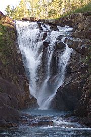
| Thousand Foot Falls Thousand Foot Falls Thousand Foot Falls is a waterfall and natural monument in Belize. It is surrounded by the Mountain Pine Ridge Forest Reserve.... |
Cayo Cayo District Cayo District is a district in the west of the nation of Belize. The District capital is the town of San Ignacio.- Geography :The Cayo District is the largest district in Belize. It is located on the western side of the country which borders Guatemala. The nation's capital, Belmopan, is... |
522 hectares (1,289.9 acre) | III | — | 2004 | Terrestrial. | |
| Victoria Peak Victoria Peak (Belize) Victoria Peak within the Maya Mountains is the second highest mountain in Belize. The highest peak in the country, Doyle's Delight at a height of , is located SW of Victoria Peak... |
Stann Creek Stann Creek District Stann Creek District is a district in the south east region of Belize. According to the 2010 census, the district had a population of 32,166 people... |
1959 hectares (4,840.8 acre) | III | Belize Audubon Society | 1998 | Terrestrial. |
Nature reserves
The country's three nature reserveNature reserve
A nature reserve is a protected area of importance for wildlife, flora, fauna or features of geological or other special interest, which is reserved and managed for conservation and to provide special opportunities for study or research...
s enjoy the highest level of protection within the national protected areas system. The designation was created for the strict protection of biological communities or ecosystems, and the maintenance of natural processes in an undisturbed state. They are typically pristine, wilderness
Wilderness
Wilderness or wildland is a natural environment on Earth that has not been significantly modified by human activity. It may also be defined as: "The most intact, undisturbed wild natural areas left on our planet—those last truly wild places that humans do not control and have not developed with...
ecosystems.
Nature reserves are legislated under the National Parks System Act of 1981. It is the strictest designation of all categories within the country's national protected areas system, with no extractive use or tourism access permitted. Permits are required to enter the area and are restricted to researchers only. The nature reserves are under the authority of the Forest Department.
The oldest of these, Bladen Nature Reserve, forms the centrepiece of the Maya Mountains
Maya Mountains
The Maya Mountains are a mountain range in Belize and eastern Guatemala. The highest peaks are Doyle's Delight at and Victoria Peak at . The Maya Mountains and associated foothills contain a number of important Mayan ruins including the sites of Lubaantun, Nim Li Punit, Cahal Pech, and Chaa Creek;...
biological corridor, and is considered one of the most biodiversity-rich, and topographically unique areas within the Mesoamerican biodiversity hotspot.
| Reserve | | District | Size (ha) | Size (acres) | | IUCN | Co-management | Est. | | Description |
|---|---|---|---|---|---|---|
| Bladen Bladen Nature Reserve Bladen Nature Reserve is a landscape of caves, sinkholes, pristine streams and rivers, undisturbed old growth rainforest and an abundance of highly diverse flora and fauna which includes a great deal of rare and endemic species.... |
Toledo Toledo District Toledo District is the southernmost district in Belize, and Punta Gorda the District capital. Although the least developed region in the country, it features some of the most pristine rainforests, extensive cave networks, coastal lowland plains, and offshore cays... |
40411 hectares (99,857.7 acre) | Ia | Ya’axché Conservation Trust; Bladen Management Consortium | 1990 | |
| Burdon Canal Burdon Canal Nature Reserve The Burdon Canal Nature Reserve in Belize is a low lying basin, comprising the backswamps of the Belize River/Haulover Creek delta. It is permanently waterlogged, with a gradient of saline to fresh water arising from regular tidal inundation at the seaward fringe and freshwater flooding from... |
Belize Belize District The Belize District is a district of the nation of Belize, with its district capital being the nation's largest city, Belize City.- Settlements :... |
2126 hectares (5,253.5 acre) | Ia | — | 1992 | |
| Tapir Mountain | Cayo Cayo District Cayo District is a district in the west of the nation of Belize. The District capital is the town of San Ignacio.- Geography :The Cayo District is the largest district in Belize. It is located on the western side of the country which borders Guatemala. The nation's capital, Belmopan, is... |
2550 hectares (6,301.2 acre) | Ia | Belize Audubon Society Belize Audubon Society The Belize Audubon Society is a non-governmental conservation organisation founded in 1969 to encourage and develop conservation initiatives in Belize. It currently manages nine of the country's protected areas in partnership with the Belizean government.... |
1994 | Formerly known as Society Hall Nature Reserve. |
Wildlife sanctuaries
Wildlife sanctuaries are created for the preservation of an important keystone speciesKeystone species
A keystone species is a species that has a disproportionately large effect on its environment relative to its abundance. Such species play a critical role in maintaining the structure of an ecological community, affecting many other organisms in an ecosystem and helping to determine the types and...
in the ecosystem. By preserving enough area for them to live in, many other species receive the protection they need as well.
Wildlife sanctuaries are gazetted under the National Parks System Act of 1981, and are the responsibility of the Forest Department. There are currently seven wildlife sanctuaries, three of which are being managed under co-management partnerships, whilst the other four are managed under informal arrangements. Two of the following wildlife sanctuaries are considered to be marine protected areas, and may also have collaborative agreements with the Fisheries Department in place.
| Reserve | | District | Size (ha) | Size (acres) | | IUCN | Co-management | Est. | | Description |
|---|---|---|---|---|---|---|
| Aguacaliente | Toledo Toledo District Toledo District is the southernmost district in Belize, and Punta Gorda the District capital. Although the least developed region in the country, it features some of the most pristine rainforests, extensive cave networks, coastal lowland plains, and offshore cays... |
2213 hectares (5,468.4 acre) | IV | Aguacaliente Management Team | 1998 | Terrestrial. |
| Cockscomb Basin Cockscomb Basin Wildlife Sanctuary The Cockscomb Basin Wildlife Sanctuary is a nature reserve in south-central Belize established to protect the forests, fauna and watersheds of an approximately 400 square kilometre area of the eastern slopes of the Maya Mountains... |
Stann Creek Stann Creek District Stann Creek District is a district in the south east region of Belize. According to the 2010 census, the district had a population of 32,166 people... / Toledo Toledo District Toledo District is the southernmost district in Belize, and Punta Gorda the District capital. Although the least developed region in the country, it features some of the most pristine rainforests, extensive cave networks, coastal lowland plains, and offshore cays... |
49477 hectares (122,260.2 acre) | IV | Belize Audubon Society Belize Audubon Society The Belize Audubon Society is a non-governmental conservation organisation founded in 1969 to encourage and develop conservation initiatives in Belize. It currently manages nine of the country's protected areas in partnership with the Belizean government.... |
1997 | Terrestrial. |
| Corozal Bay | Belize Belize District The Belize District is a district of the nation of Belize, with its district capital being the nation's largest city, Belize City.- Settlements :... / Corozal Corozal District Corozal District is the northernmost district of the nation of Belize. The population was 33,335 as of 2000. The district capital is Corozal Town.-The Villages of Corozal District:... |
73049 hectares (180,507.9 acre) | IV | Sarteneja Alliance for Conservation and Development | 1998 | Marine. |
| Crooked Tree Crooked Tree Wildlife Sanctuary The Crooked Tree Wildlife Sanctuary is a wildlife reserve in Belize. It is particularly important for birds, which flock to the area during the dry season, to take advantage of the shallow waters, and abundance of food resources.... |
Belize Belize District The Belize District is a district of the nation of Belize, with its district capital being the nation's largest city, Belize City.- Settlements :... / Orange Walk Orange Walk District Orange Walk District is a district in the northwest of the nation of Belize, with its district capital in Orange Walk Town.- Main settlements :... |
15372 hectares (37,985 acre) | IV | Belize Audubon Society | 1984 | Ramsar site. Boundaries ill defined. Terrestrial. |
| Gales Point | Belize Belize District The Belize District is a district of the nation of Belize, with its district capital being the nation's largest city, Belize City.- Settlements :... |
3681 hectares (9,095.9 acre) | IV | Gales Point Wildlife Sanctuary Community Management Committee | 1998 | Terrestrial. |
| Spanish Creek | Belize Belize District The Belize District is a district of the nation of Belize, with its district capital being the nation's largest city, Belize City.- Settlements :... / Orange Walk Orange Walk District Orange Walk District is a district in the northwest of the nation of Belize, with its district capital in Orange Walk Town.- Main settlements :... |
2428 hectares (5,999.7 acre) | IV | Rancho Dolores Development Group | 2002 | Terrestrial. |
| Swallow Caye | Belize Belize District The Belize District is a district of the nation of Belize, with its district capital being the nation's largest city, Belize City.- Settlements :... |
3631 hectares (8,972.4 acre) | IV | Friends of Swallow Caye | 2002 | Marine. |
Forest reserves
Logging
Logging is the cutting, skidding, on-site processing, and loading of trees or logs onto trucks.In forestry, the term logging is sometimes used in a narrow sense concerning the logistics of moving wood from the stump to somewhere outside the forest, usually a sawmill or a lumber yard...
without destroying the biodiversity of the location. These are gazetted under the Forests Act of 1927, which allows the department to grant permits to logging companies after extensive review. There are currently 16 forest reserves with a combined acreage of 380328 hectares (939,810.1 acre), making up 9.3% of total national territory.
| Reserve | | District | Size (ha) | Size (acres) | | IUCN | Est. | | Description |
|---|---|---|---|---|---|
| Caye Caulker Caye Caulker Caye Caulker is a small limestone coral island off the coast of Belize in the Caribbean Sea measuring about by less than . The town on the island is known by the name Caye Caulker Village... |
Belize Belize District The Belize District is a district of the nation of Belize, with its district capital being the nation's largest city, Belize City.- Settlements :... |
38 hectares (93.9 acre) | VI | 1998 | Excludes adjacent marine reserve. |
| Chiquibul | Cayo Cayo District Cayo District is a district in the west of the nation of Belize. The District capital is the town of San Ignacio.- Geography :The Cayo District is the largest district in Belize. It is located on the western side of the country which borders Guatemala. The nation's capital, Belmopan, is... |
59822 hectares (147,823.3 acre) | VI | 1995 | Excludes adjacent national park. |
| Columbia River | Cayo Cayo District Cayo District is a district in the west of the nation of Belize. The District capital is the town of San Ignacio.- Geography :The Cayo District is the largest district in Belize. It is located on the western side of the country which borders Guatemala. The nation's capital, Belmopan, is... / Toledo Toledo District Toledo District is the southernmost district in Belize, and Punta Gorda the District capital. Although the least developed region in the country, it features some of the most pristine rainforests, extensive cave networks, coastal lowland plains, and offshore cays... |
60016 hectares (148,302.6 acre) | VI | 1997 | |
| Deep River | Toledo Toledo District Toledo District is the southernmost district in Belize, and Punta Gorda the District capital. Although the least developed region in the country, it features some of the most pristine rainforests, extensive cave networks, coastal lowland plains, and offshore cays... |
27232 hectares (67,291.7 acre) | VI | ||
| Fresh Water Creek | Corozal Corozal District Corozal District is the northernmost district of the nation of Belize. The population was 33,335 as of 2000. The district capital is Corozal Town.-The Villages of Corozal District:... / Orange Walk Orange Walk District Orange Walk District is a district in the northwest of the nation of Belize, with its district capital in Orange Walk Town.- Main settlements :... |
13513 hectares (33,391.3 acre) | VI | 1926 | |
| Grants Work | Stann Creek Stann Creek District Stann Creek District is a district in the south east region of Belize. According to the 2010 census, the district had a population of 32,166 people... |
3199 hectares (7,904.9 acre) | VI | 1989 | |
| Machaca | Toledo Toledo District Toledo District is the southernmost district in Belize, and Punta Gorda the District capital. Although the least developed region in the country, it features some of the most pristine rainforests, extensive cave networks, coastal lowland plains, and offshore cays... |
1253 hectares (3,096.2 acre) | VI | 1998 | |
| Manatee | Belize Belize District The Belize District is a district of the nation of Belize, with its district capital being the nation's largest city, Belize City.- Settlements :... / Stann Creek Stann Creek District Stann Creek District is a district in the south east region of Belize. According to the 2010 census, the district had a population of 32,166 people... |
36621 hectares (90,492.4 acre) | VI | 1959 | |
| Mango Creek | Stann Creek Stann Creek District Stann Creek District is a district in the south east region of Belize. According to the 2010 census, the district had a population of 32,166 people... / Toledo Toledo District Toledo District is the southernmost district in Belize, and Punta Gorda the District capital. Although the least developed region in the country, it features some of the most pristine rainforests, extensive cave networks, coastal lowland plains, and offshore cays... |
12090 hectares (29,875 acre) | VI | 1989 | Comprises two separate segments. |
| Monkey Caye | Toledo Toledo District Toledo District is the southernmost district in Belize, and Punta Gorda the District capital. Although the least developed region in the country, it features some of the most pristine rainforests, extensive cave networks, coastal lowland plains, and offshore cays... |
669 hectares (1,653.1 acre) | VI | 1996 | |
| Mountain Pine Ridge Mountain Pine Ridge Forest Reserve Mountain Pine Ridge Forest Reserve is a nature reserve in the Cayo District of southern central Belize. It was established in 1944 to protect and manage the native pine forest... |
Cayo Cayo District Cayo District is a district in the west of the nation of Belize. The District capital is the town of San Ignacio.- Geography :The Cayo District is the largest district in Belize. It is located on the western side of the country which borders Guatemala. The nation's capital, Belmopan, is... |
43372 hectares (107,174.5 acre) | VI | 1944 | |
| Maya Mountain | Stann Creek Stann Creek District Stann Creek District is a district in the south east region of Belize. According to the 2010 census, the district had a population of 32,166 people... |
16887 hectares (41,728.6 acre) | VI | 1997 | |
| Sibun | Cayo Cayo District Cayo District is a district in the west of the nation of Belize. The District capital is the town of San Ignacio.- Geography :The Cayo District is the largest district in Belize. It is located on the western side of the country which borders Guatemala. The nation's capital, Belmopan, is... |
32849 hectares (81,171.6 acre) | VI | 1959 | |
| Sittee River | Stann Creek Stann Creek District Stann Creek District is a district in the south east region of Belize. According to the 2010 census, the district had a population of 32,166 people... |
37360 hectares (92,318.5 acre) | VI | ||
| Swasey Bladen | Toledo Toledo District Toledo District is the southernmost district in Belize, and Punta Gorda the District capital. Although the least developed region in the country, it features some of the most pristine rainforests, extensive cave networks, coastal lowland plains, and offshore cays... |
5980 hectares (14,776.9 acre) | VI | 1989 | |
| Vaca | Cayo Cayo District Cayo District is a district in the west of the nation of Belize. The District capital is the town of San Ignacio.- Geography :The Cayo District is the largest district in Belize. It is located on the western side of the country which borders Guatemala. The nation's capital, Belmopan, is... |
14118 hectares (34,886.3 acre) | VI | 1991 |
Marine reserves
Marine Protected Area
Marine Protected Areas, like any protected area, are regions in which human activity has been placed under some restrictions in the interest of conserving the natural environment, it's surrounding waters and the occupant ecosystems, and any cultural or historical resources that may require...
are designed for the conservation
Marine conservation
Marine conservation, also known as marine resources conservation, is the protection and preservation of ecosystems in oceans and seas. Marine conservation focuses on limiting human-caused damage to marine ecosystems, and on restoring damaged marine ecosystems...
of aquatic ecosystem
Aquatic ecosystem
An aquatic ecosystem is an ecosystem in a body of water. Communities of organisms that are dependent on each other and on their environment live in aquatic ecosystems. The two main types of aquatic ecosystems are marine ecosystems and freshwater ecosystems....
s, including marine wildlife and its environment. The majority of these reserves contribute to the conservation of Belize's Barrier Reef
Belize Barrier Reef
The Belize Barrier Reef is a series of coral reefs straddling the coast of Belize, roughly offshore in the north and in the south within the country limits...
, which provides a protective shelter
Barrier reef
Barrier reef may refer to:*a kind of coral reef*the Great Barrier Reef in Australia*the Mesoamerican Barrier Reef System*the Belize Barrier Reef*the New Caledonia Barrier Reef*Barrier Reef , an Australian television series...
for pristine atolls, seagrass meadows and rich marine life. The preservation of the Barrier Reef system has been recognised as a global interest through the collective designation of seven protected areas, including four of the following marine reserves, as a World Heritage Site.
Marine reserves are legislated under the Fisheries Act, and are administered by the Fisheries Department. One of the department's key responsibilities is to ensure the sustainable extraction of marine resources
Sustainable fisheries
Sustainability in fisheries combines theoretical disciplines, such as the population dynamics of fisheries, with practical strategies, such as avoiding overfishing through techniques such as individual fishing quotas, curtailing destructive and illegal fishing practices by lobbying for appropriate...
. There are currently eight marine reserves, management of which is either direct, by the department, or in partnership with non-governmental agencies.
| Reserve | | District | Size (ha) | Size (acres) | | IUCN | Co-management | Est. | | Description |
|---|---|---|---|---|---|---|
| Bacalar Chico Bacalar Chico National Park and Marine Reserve Bacalar Chico National Park and Marine Reserve is a protected area and UNESCO World Heritage Site on the northern part of Ambergris Caye in Belize.-History:... |
Belize Belize District The Belize District is a district of the nation of Belize, with its district capital being the nation's largest city, Belize City.- Settlements :... |
6391 hectares (15,792.5 acre) | IV | Green Reef Environmental Institute | 1996 | Excludes adjacent national park. Divided into two zones: a conservation zone, and a general use zone. |
| Caye Caulker Caye Caulker Caye Caulker is a small limestone coral island off the coast of Belize in the Caribbean Sea measuring about by less than . The town on the island is known by the name Caye Caulker Village... |
Belize Belize District The Belize District is a district of the nation of Belize, with its district capital being the nation's largest city, Belize City.- Settlements :... |
3913 hectares (9,669.2 acre) | VI | Forest & Marine Reserves Association of Caye Caulker | 1998 | Excludes adjacent forest reserve. |
| Gladden Spit and Silk Cayes Gladden Spit and Silk Cayes Marine Reserve Gladden Spit and Silk Cayes Marine Reserve is a protected marine reserve in the central part of Belize's Barrier Reef. It covers approximately lying off the coast of Placencia... |
Stann Creek Stann Creek District Stann Creek District is a district in the south east region of Belize. According to the 2010 census, the district had a population of 32,166 people... |
10514 hectares (25,980.6 acre) | IV | Southern Environmental Association | 2000 | Divided into two zones: a general use zone, and a conservation zone. |
| Glover's Reef Glover's Reef Glover's Reef is a partially submerged atoll located off the southern coast of Belize, approximately 45 kilometres from the mainland. It forms part of the outermost boundary of the Belize Barrier Reef.-Topography:... |
Belize Belize District The Belize District is a district of the nation of Belize, with its district capital being the nation's largest city, Belize City.- Settlements :... |
86653 hectares (214,124 acre) | IV | — | 1993 | In 2001, the reserve was divided into four zones: a general use zone, a conservation zone, a seasonal closure zone, and a wilderness zone. A spawning aggregation zone was broken off in 2003 and comes under separate management (see below). |
| Hol Chan Hol Chan Marine Reserve Hol Chan Marine Reserve is a marine reserve close to Ambergris Caye and Caye Caulker, off the coast of Belize. It covers approximately 18 km² of coral reefs, seagrass beds, and mangrove forest... |
Belize Belize District The Belize District is a district of the nation of Belize, with its district capital being the nation's largest city, Belize City.- Settlements :... |
1444 hectares (3,568.2 acre) | II | Hol Chan Trust Fund | 1987 | Divided into four zones: Mangrove, Seagrass, Shark Ray Alley, and Coral Reef. |
| Port Honduras Port Honduras Marine Reserve Port Honduras Marine Reserve is a national protected marine reserve in the Toledo district of Belize. It was established in January 2000, and covers of mangrove and coastal ecosystems... |
Toledo Toledo District Toledo District is the southernmost district in Belize, and Punta Gorda the District capital. Although the least developed region in the country, it features some of the most pristine rainforests, extensive cave networks, coastal lowland plains, and offshore cays... |
40470 hectares (100,003.5 acre) | IV | Toledo Institute for Development and Environment | 2000 | Divided into two zones: a general use zone, and a conservation zone. |
| Sapodilla Cayes Sapodilla Cayes Sapodilla Cayes is an uninhabited atoll in the Gulf of Honduras. It is generally considered to be within the territorial waters of Belize, but Guatemala claims that the Belize–Guatemala maritime boundary is northwest of Sapodilla... |
Toledo Toledo District Toledo District is the southernmost district in Belize, and Punta Gorda the District capital. Although the least developed region in the country, it features some of the most pristine rainforests, extensive cave networks, coastal lowland plains, and offshore cays... |
15618 hectares (38,592.9 acre) | IV | Southern Environmental Association | 1996 | |
| South Water Caye South Water Caye Marine Reserve South Water Caye Marine Reserve is the largest marine reserve in the Stann Creek district of Belize. It was established in 1996 and covers of mangrove and coastal ecosystems.... |
Stann Creek Stann Creek District Stann Creek District is a district in the south east region of Belize. According to the 2010 census, the district had a population of 32,166 people... |
47702 hectares (117,874.1 acre) | IV | — | 1996 |
Spawning aggregation sites
| Aggregation zone | | District | Size (ha) | Size (acres) | | IUCN | Est. | | Description |
|---|---|---|---|---|---|
| Dog Flea | Belize Belize District The Belize District is a district of the nation of Belize, with its district capital being the nation's largest city, Belize City.- Settlements :... |
576 hectares (1,423.3 acre) | IV | 2003 | |
| Emily or Glory Caye | Belize Belize District The Belize District is a district of the nation of Belize, with its district capital being the nation's largest city, Belize City.- Settlements :... |
0 hectare (0 acre) | IV | 2003 | |
| Gladden Spit | Belize Belize District The Belize District is a district of the nation of Belize, with its district capital being the nation's largest city, Belize City.- Settlements :... |
1617 hectares (3,995.7 acre) | IV | 2003 | Managed as part of Gladden Spit and Silk Cayes Marine Reserve. |
| Nicholas Caye | Belize Belize District The Belize District is a district of the nation of Belize, with its district capital being the nation's largest city, Belize City.- Settlements :... |
673 hectares (1,663 acre) | IV | 2003 | Managed as part of Sapodilla Marine Reserve. |
| Northern Glover's Reef | Belize Belize District The Belize District is a district of the nation of Belize, with its district capital being the nation's largest city, Belize City.- Settlements :... |
621 hectares (1,534.5 acre) | IV | 2003 | Managed as part of Glover's Reef Marine Reserve. |
| Rise and Fall Bank | Belize Belize District The Belize District is a district of the nation of Belize, with its district capital being the nation's largest city, Belize City.- Settlements :... |
1721 hectares (4,252.7 acre) | IV | 2003 | |
| Rocky Point | Belize Belize District The Belize District is a district of the nation of Belize, with its district capital being the nation's largest city, Belize City.- Settlements :... |
570 hectares (1,408.5 acre) | IV | 2003 | Managed as part of Bacalar Chico Marine Reserve. |
| Sandbore | Belize Belize District The Belize District is a district of the nation of Belize, with its district capital being the nation's largest city, Belize City.- Settlements :... |
521 hectares (1,287.4 acre) | IV | 2003 | |
| Seal Caye | Toledo Toledo District Toledo District is the southernmost district in Belize, and Punta Gorda the District capital. Although the least developed region in the country, it features some of the most pristine rainforests, extensive cave networks, coastal lowland plains, and offshore cays... |
648 hectares (1,601.2 acre) | IV | 2003 | |
| South Point Lighthouse | Belize Belize District The Belize District is a district of the nation of Belize, with its district capital being the nation's largest city, Belize City.- Settlements :... |
533 hectares (1,317.1 acre) | IV | 2003 | |
| South Point Turneffe | Belize Belize District The Belize District is a district of the nation of Belize, with its district capital being the nation's largest city, Belize City.- Settlements :... |
558 hectares (1,378.8 acre) | IV | 2003 |
Bird sanctuaries
The seven bird sanctuaries are some of the country's oldest protected areas established for the purpose of biodiversity conservation. They were gazetted in 1977 as crown reservesCrown land
In Commonwealth realms, Crown land is an area belonging to the monarch , the equivalent of an entailed estate that passed with the monarchy and could not be alienated from it....
for the protection of waterfowl
Waterfowl
Waterfowl are certain wildfowl of the order Anseriformes, especially members of the family Anatidae, which includes ducks, geese, and swans....
nesting and roosting colonies
Bird colony
A bird colony is a large congregation of individuals of one or more species of bird that nest or roost in close proximity at a particular location. Many kinds of birds are known to congregate in groups of varying size; a congregation of nesting birds is called a breeding colony...
. They were later reorganised under the National Parks System Act in 1981. They are under the jurisdiction of the Forest Department. All of them are tiny islands with a combined surface area of 6 hectares (14.8 acre).
All the sanctuaries are nesting and roosting sites for wading birds, though the species vary.
| Reserve | | District | Size (ha) | Size (acres) | | IUCN | Est. | | Description |
|---|---|---|---|---|---|
| Bird Caye | Belize Belize District The Belize District is a district of the nation of Belize, with its district capital being the nation's largest city, Belize City.- Settlements :... |
0.5 hectares (1.2 acre) | IV | 1977 | |
| Doubloon Bank | Orange Walk Orange Walk District Orange Walk District is a district in the northwest of the nation of Belize, with its district capital in Orange Walk Town.- Main settlements :... |
1.5 hectares (3.7 acre) | IV | 1977 | |
| Little Guana Caye | Belize Belize District The Belize District is a district of the nation of Belize, with its district capital being the nation's largest city, Belize City.- Settlements :... |
1 hectares (2.5 acre) | IV | 1977 | |
| Los Salones | Belize Belize District The Belize District is a district of the nation of Belize, with its district capital being the nation's largest city, Belize City.- Settlements :... |
1 hectares (2.5 acre) | IV | 1977 | |
| Monkey Caye | Toledo Toledo District Toledo District is the southernmost district in Belize, and Punta Gorda the District capital. Although the least developed region in the country, it features some of the most pristine rainforests, extensive cave networks, coastal lowland plains, and offshore cays... |
0.5 hectares (1.2 acre) | IV | 1977 | |
| Man of War Caye | Toledo Toledo District Toledo District is the southernmost district in Belize, and Punta Gorda the District capital. Although the least developed region in the country, it features some of the most pristine rainforests, extensive cave networks, coastal lowland plains, and offshore cays... |
1 hectares (2.5 acre) | IV | 1977 | |
| Unnamed Caye | Belize Belize District The Belize District is a district of the nation of Belize, with its district capital being the nation's largest city, Belize City.- Settlements :... |
0.5 hectares (1.2 acre) | IV | 1977 |
Archaeological reserves
Before the arrival of Europeans in America, Belize lay in the heartland of the Maya civilisation, and consequently contains some of the earliest and most important Maya ruins. Archaeological findings at CaracolCaracol
Caracol is the name given to a large ancient Maya archaeological site, located in what is now the Cayo District of Belize. It is situated approximately 40 kilometres south of Xunantunich and the town of San Ignacio Cayo, and 15 kilometers away from the Macal River. It rests on the Vaca Plateau at...
, in the southern end of the country, have suggested that it formed the centre of political struggles in the southern Maya lowlands. The complex covered an area much larger than present-day Belize City
Belize City
Belize City is the largest city in the Central American nation of Belize. Unofficial estimates place the population of Belize City at 70,000 or more. It is located at the mouth of the Belize River on the coast of the Caribbean. The city is the country's principal port and its financial and...
and supported more than twice the modern city's population. Meanwhile, Lamanai
Lamanai
Lamanai is a Mesoamerican archaeological site, and was once a considerably sized city of the Maya civilization, located in the north of Belize, in Orange Walk District...
, in the north, is known for being the longest continually-occupied site in Mesoamerica
Mesoamerica
Mesoamerica is a region and culture area in the Americas, extending approximately from central Mexico to Belize, Guatemala, El Salvador, Honduras, Nicaragua, and Costa Rica, within which a number of pre-Columbian societies flourished before the Spanish colonization of the Americas in the 15th and...
, settled during the early Preclassic era
Mesoamerican chronology
Mesoamerican chronology divides the history of pre-Columbian Mesoamerica into several periods: the Paleo-Indian , the Archaic , the Preclassic , the Classic , and the Postclassic...
and continuously occupied up to and during the area's colonisation.
While the majority of reserves under this category are related to the pre-colonial era, Serpon Sugar Mill
Serpon Sugar Mill
Serpon Sugar Mill is an historical site in Belize, consisting of the remnants of a steam-powered sugar mill whose constructed in 1865 marked the beginning of the country's industrial era...
and Yarborough Cemetery
Yarborough Cemetery
Yarborough Cemetery is an historical cemetery located in Belize City, Belize. It was the first cemetery in British Honduras, used from 1787 until 1896, and was established for the burial of members of the colonial Anglican Church. It was named after the magistrate who owned the land...
, both designated in 2009, only date from the 19th century and are alternatively described as historical reserves
Historic site
A historic site is an official location where pieces of political, military or social history have been preserved. Historic sites are usually protected by law, and many have recognized with the official national historic site status...
.
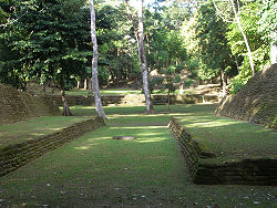
The country's 15 archaeological site
Archaeological site
An archaeological site is a place in which evidence of past activity is preserved , and which has been, or may be, investigated using the discipline of archaeology and represents a part of the archaeological record.Beyond this, the definition and geographical extent of a 'site' can vary widely,...
s are managed by the Institute of Archaeology, a branch of the National Institute of Culture and History (NICH), which comes under the authority of the Ministry of Tourism, Civil Aviation and Culture. This type of protected area was gazetted under the Ancient Monuments and Antiquities Act, 1 May 1972. All of the following reserves are open to the public. Many other sites, such as Cuello
Cuello
Cuello is a Maya archaeological site in northern Belize. The site is that of a farming village with a long occupational history stretching back to approximately 1200 BC, during the Middle Preclassic period. Its inhabitants lived in pole-and-thatch houses that were built on top of low plaster-coated...
and Uxbenka
Uxbenka
Uxbenka is a pre-Columbian Mesoamerican archaeological site located in Belize's southernmost district of Toledo. An urban settlement of the pre-Columbian Maya, it is the earliest-known Maya polity in the southern Belizean lowlands, with evidence of occupation dating to the Early Classic period of...
, are located on private land and can only be visited if prior permission is obtained from the landowner.
| Image | | Reserve | | District | Size (ha) | Size (acres) | | IUCN | Est. | | Description |
|---|---|---|---|---|---|---|
| Altun Ha Altun Ha Altun Ha is the name given ruins of an ancient Maya city in Belize, located in the Belize District about 30 miles north of Belize City and about 6 miles west of the shore of the Caribbean Sea.... |
Belize Belize District The Belize District is a district of the nation of Belize, with its district capital being the nation's largest city, Belize City.- Settlements :... |
15.5 hectares (38.3 acre) | II | 1995 | ||
| Barton Creek Barton Creek Cave Barton Creek Cave is a natural cave in Belize, known as both an archaeological site and as a tourist destination. It is located near San Ignacio in the Cayo District.- Physical description :... |
Belize Belize District The Belize District is a district of the nation of Belize, with its district capital being the nation's largest city, Belize City.- Settlements :... |
2 hectares (4.9 acre) | II | 2003 | ||
| Cahal Pech Cahal Pech Cahal Pech is a Maya site located near the Town of San Ignacio in the Cayo District of Belize. The site was a hilltop palacio home for an elite Maya family, and though most major construction dates to the Classic period, evidence of continuous habitation has been dated to as far back as far as 1200... |
Cayo Cayo District Cayo District is a district in the west of the nation of Belize. The District capital is the town of San Ignacio.- Geography :The Cayo District is the largest district in Belize. It is located on the western side of the country which borders Guatemala. The nation's capital, Belmopan, is... |
9 hectares (22.2 acre) | II | 1995 | ||
| Caracol Caracol Caracol is the name given to a large ancient Maya archaeological site, located in what is now the Cayo District of Belize. It is situated approximately 40 kilometres south of Xunantunich and the town of San Ignacio Cayo, and 15 kilometers away from the Macal River. It rests on the Vaca Plateau at... |
Cayo Cayo District Cayo District is a district in the west of the nation of Belize. The District capital is the town of San Ignacio.- Geography :The Cayo District is the largest district in Belize. It is located on the western side of the country which borders Guatemala. The nation's capital, Belmopan, is... |
10339 hectares (25,548.2 acre) | II | 1995 | ||
| Cerro Maya Cerros Cerros is a Maya archaeological site in northern Belize that reached its apogee during the Mesoamerican Late Preclassic. At its nadir, it held a population of approximately 1,089 people. The site is strategically located on a peninsula at the mouth of the New River where it empties into Chetumal... |
Corozal Corozal District Corozal District is the northernmost district of the nation of Belize. The population was 33,335 as of 2000. The district capital is Corozal Town.-The Villages of Corozal District:... |
10 hectares (24.7 acre) | II | 1976 | ||
| El Pilar El Pilar El Pilar is an ancient Maya city center located on the Belize-Guatemala border. It can be accessed from the Cayo District in Belize, north-west of the town of San Ignacio, or from the department of El Petén in Guatemala, north of Melchor de Mencos.... |
Cayo Cayo District Cayo District is a district in the west of the nation of Belize. The District capital is the town of San Ignacio.- Geography :The Cayo District is the largest district in Belize. It is located on the western side of the country which borders Guatemala. The nation's capital, Belmopan, is... |
771 hectares (1,905.2 acre) | II | 1998 | ||
| Lamanai Lamanai Lamanai is a Mesoamerican archaeological site, and was once a considerably sized city of the Maya civilization, located in the north of Belize, in Orange Walk District... |
Orange Walk Orange Walk District Orange Walk District is a district in the northwest of the nation of Belize, with its district capital in Orange Walk Town.- Main settlements :... |
396 hectares (978.5 acre) | II | 1985 | ||
| Lubaantun Lubaantun Lubaantun is a pre-Columbian ruined city of the Maya civilization in southern Belize, Central America... |
Toledo Toledo District Toledo District is the southernmost district in Belize, and Punta Gorda the District capital. Although the least developed region in the country, it features some of the most pristine rainforests, extensive cave networks, coastal lowland plains, and offshore cays... |
16 hectares (39.5 acre) | II | 1995 | ||
| Marco Gonzalez Marco Gonzalez Marco Gonzales is a Maya archaeological site located near the southern tip of Ambergris Caye off the coast of Belize. It was first recorded in 1984 by Drs... |
Belize Belize District The Belize District is a district of the nation of Belize, with its district capital being the nation's largest city, Belize City.- Settlements :... |
3.1 hectares (7.7 acre) | II | 2011 | ||
 |
Nim Li Punit Nim Li Punit Nim Li Punit, is a Maya Classic Period site in the Toledo District of the nation of Belize, located 40 kilometres north of the town of Punta Gorda, at 16° 19' N, 88° 47' 60W... |
Toledo Toledo District Toledo District is the southernmost district in Belize, and Punta Gorda the District capital. Although the least developed region in the country, it features some of the most pristine rainforests, extensive cave networks, coastal lowland plains, and offshore cays... |
24 hectares (59.3 acre) | II | 1985 | |
| Nohoch Che'en Nohoch Che'en Nohoch Che'en, also commonly known as Caves Branch, is an archaeological reserve in Belize, consisting of a network of limestone caves.... |
Cayo Cayo District Cayo District is a district in the west of the nation of Belize. The District capital is the town of San Ignacio.- Geography :The Cayo District is the largest district in Belize. It is located on the western side of the country which borders Guatemala. The nation's capital, Belmopan, is... |
7 hectares (17.3 acre) | II | 2010 | Also known as Caves Branch. Formerly a private reserve owned by Jaguar Paw. | |
| Santa Rita | Corozal Corozal District Corozal District is the northernmost district of the nation of Belize. The population was 33,335 as of 2000. The district capital is Corozal Town.-The Villages of Corozal District:... |
0.1 hectare (0.247105163015276 acre) | II | 1995 | ||
| Serpon Sugar Mill Serpon Sugar Mill Serpon Sugar Mill is an historical site in Belize, consisting of the remnants of a steam-powered sugar mill whose constructed in 1865 marked the beginning of the country's industrial era... |
Stann Creek Stann Creek District Stann Creek District is a district in the south east region of Belize. According to the 2010 census, the district had a population of 32,166 people... |
13 hectares (32.1 acre) | II | 2009 | ||
| Xunantunich Xunantunich Xunantunich is a Maya archaeological site in western Belize, about 80 miles west of Belize City , in the Cayo District. Xunantunich is located atop a ridge above the Mopan River, within sight of the Guatemala border... |
Cayo Cayo District Cayo District is a district in the west of the nation of Belize. The District capital is the town of San Ignacio.- Geography :The Cayo District is the largest district in Belize. It is located on the western side of the country which borders Guatemala. The nation's capital, Belmopan, is... |
3 hectares (7.4 acre) | II | 1995 | ||
| Yarborough Cemetery Yarborough Cemetery Yarborough Cemetery is an historical cemetery located in Belize City, Belize. It was the first cemetery in British Honduras, used from 1787 until 1896, and was established for the burial of members of the colonial Anglican Church. It was named after the magistrate who owned the land... |
Belize Belize District The Belize District is a district of the nation of Belize, with its district capital being the nation's largest city, Belize City.- Settlements :... |
0.5 hectares (1.2 acre) | II | 2009 |
Private reserves
Private reservesPrivate protected area
A Private Protected Area, also known as a 'Private Reserve' is not an official category within IUCN's Protected Area guidelines, but simply encompasses those protected areas that fall under geographical space that is privately owned and 'kept aside' for public benefit and will be likely to fall...
are owned and operated by non-governmental conservation initiatives, and enjoy various levels of protection. Most of them are essentially multiple-use reserves, and include managed extraction of resources.
In 2003, the Belize Association of Private Protected Areas (BAPPA) was formed to assist in the co-ordinatation of private conservation initiatives as a cohesive group, and to represent and assist landowners in attaining recognition from the Belizean government and integration into the national protected areas system. It maintains a directory of landowners that are attempting to manage their land holdings for conservation purposes.
A total of eight private reserves have so far been officially recognised as national protected areas. It should be noted that whilst most of these recognised reserves have no formal or legal commitment to remain under conservation management, there are additional private landholdings which are considered to be very effective in biodiversity conservation and critical to the national protected areas system, but which are not yet recognised within the system. Formal adoption and implementation of proposed legislation to manage and regulate such areas is required to attain such recognition.
Official
As of January 2005, a total of eight private reserves were officially recognised as being part of the country's national protected areas system. Two have a standing agreement with the government, while the remaining six have their own management system in place. Of the following, Aguacate Lagoon is the only non-participatory reserve, its management expressing little interest in being part of the system.They cover a combined total area of approximately 131663 hectares (325,346.1 acre).
| Reserve | | District | Size (ha) | Size (acres) | | IUCN | Management | Est. | | Description |
|---|---|---|---|---|---|---|
| Aguacate Lagoon | Cayo Cayo District Cayo District is a district in the west of the nation of Belize. The District capital is the town of San Ignacio.- Geography :The Cayo District is the largest district in Belize. It is located on the western side of the country which borders Guatemala. The nation's capital, Belmopan, is... |
115 hectares (284.2 acre) | IV | Aguacate Park | 1987 | |
| Block 127 | Toledo Toledo District Toledo District is the southernmost district in Belize, and Punta Gorda the District capital. Although the least developed region in the country, it features some of the most pristine rainforests, extensive cave networks, coastal lowland plains, and offshore cays... |
3736 hectares (9,231.8 acre) | IV | Toledo Institute for Development and Environment | 2001 | Forms one block of the TIDE Private Protected Lands, which total 12000 hectares (29,652.6 acre). |
| Community Baboon Sanctuary | Belize Belize District The Belize District is a district of the nation of Belize, with its district capital being the nation's largest city, Belize City.- Settlements :... |
5253 hectares (12,980.4 acre) | IV | Women's Conservation Group | 1985 | |
| Golden Stream | Toledo Toledo District Toledo District is the southernmost district in Belize, and Punta Gorda the District capital. Although the least developed region in the country, it features some of the most pristine rainforests, extensive cave networks, coastal lowland plains, and offshore cays... |
6085 hectares (15,036.3 acre) | IV | Ya’axché Conservation Trust; Fauna & Flora International | 1998 | Formally known as Golden Stream Corridor Preserve. |
| Monkey Bay | Belize Belize District The Belize District is a district of the nation of Belize, with its district capital being the nation's largest city, Belize City.- Settlements :... |
465 hectares (1,149 acre) | IV | Monkey Bay Wildlife Sanctuary | 1987 | Formally known as Monkey Bay Wildlife Sanctuary. |
| Río Bravo Rio Bravo Conservation and Management Area Rio Bravo Conservation and Management Area is a nature reserve located in northwestern Belize. Rio Bravo, as it is known, was established by Programme for Belize in 1988 with the purchase of 110,044 acres of land from Gallon Jug Agroindustries. With logging encroachment imminent in 1989, the... |
Orange Walk Orange Walk District Orange Walk District is a district in the northwest of the nation of Belize, with its district capital in Orange Walk Town.- Main settlements :... |
104897 hectares (259,205.9 acre) | IV | Programme for Belize Programme for Belize The Programme for Belize is the first project undertaken by the World Land Trust, in 1989. The goal of the project was to purchase and protect tropical rainforests in Belize to save them from exploitation like over-logging. The project was initiated by a fundraiser held in the London Butterfly... |
1988 | Formally known as Río Bravo Conservation and Management Area. |
| Runaway Creek | Belize Belize District The Belize District is a district of the nation of Belize, with its district capital being the nation's largest city, Belize City.- Settlements :... |
2431 hectares (6,007.1 acre) | IV | Foundation for Wildlife Conservation; Birds Without Borders | 1998 | |
| Shipstern | Corozal Corozal District Corozal District is the northernmost district of the nation of Belize. The population was 33,335 as of 2000. The district capital is Corozal Town.-The Villages of Corozal District:... |
8228 hectares (20,331.8 acre) | IV | International Tropical Conservation Foundation; Papiliorama-Nocturama Foundation | 1987 | Formally known as Shipstern Nature Reserve. |
Proposed
| Reserve | | District | Size (ha) | Size (acres) | | IUCN | Management | Est. | | Description |
|---|---|---|---|---|---|---|
| Balam Na | Corozal Corozal District Corozal District is the northernmost district of the nation of Belize. The population was 33,335 as of 2000. The district capital is Corozal Town.-The Villages of Corozal District:... |
166 hectares (410.2 acre) | IV | Wildtracks; Tropical Rainforest Coalition | 2000 | |
| BFREE | Toledo Toledo District Toledo District is the southernmost district in Belize, and Punta Gorda the District capital. Although the least developed region in the country, it features some of the most pristine rainforests, extensive cave networks, coastal lowland plains, and offshore cays... |
572 hectares (1,413.4 acre) | IV | Belize Foundation for Research & Environmental Education | 1995 | |
| Boden Creek | Toledo Toledo District Toledo District is the southernmost district in Belize, and Punta Gorda the District capital. Although the least developed region in the country, it features some of the most pristine rainforests, extensive cave networks, coastal lowland plains, and offshore cays... |
5447 hectares (13,459.8 acre) | IV | Belize Lodge and Excursions | 1998 | Formally know as Boden Creek Ecological Preserve. |
| Fireburn | Corozal Corozal District Corozal District is the northernmost district of the nation of Belize. The population was 33,335 as of 2000. The district capital is Corozal Town.-The Villages of Corozal District:... |
745 hectares (1,840.9 acre) | IV | Wildtracks; Fireburn Community | ||
| Gallon Jug | Orange Walk Orange Walk District Orange Walk District is a district in the northwest of the nation of Belize, with its district capital in Orange Walk Town.- Main settlements :... |
54154 hectares (133,817.3 acre) | IV | Gallon Jug Estate | ||
| Green Hills | Cayo Cayo District Cayo District is a district in the west of the nation of Belize. The District capital is the town of San Ignacio.- Geography :The Cayo District is the largest district in Belize. It is located on the western side of the country which borders Guatemala. The nation's capital, Belmopan, is... |
43 hectares (106.3 acre) | IV | Meerman, Jan | 1996 | Formally known as Green Hills Private Conservation Management Area. |
| Hidden Valley | Cayo Cayo District Cayo District is a district in the west of the nation of Belize. The District capital is the town of San Ignacio.- Geography :The Cayo District is the largest district in Belize. It is located on the western side of the country which borders Guatemala. The nation's capital, Belmopan, is... |
2925 hectares (7,227.8 acre) | IV | Hidden Valley Institute |
Others
Others- St. Georges Caye Mangrove Reserve http://www.biodiversity.bz/find/protected_area/profile.phtml?pa_id=107642
- Commerce Bight Forest Reserve (1986), 1200 hectares (2,965.3 acre)
- Dolphin Park National Public Reserve http://www.biodiversity.bz/find/protected_area/profile.phtml?pa_id=107619
- Krooman Reserve http://www.biodiversity.bz/find/protected_area/profile.phtml?pa_id=107632
- Mexico RocksMexico RocksMexico Rocks is a shallow patch reef complex located off the far northern tip of Ambergris Caye, in the Belizean Barrier Reef. The site consists of approximately 100 Holocene patch reefs, clustered on a ridge of Pleistocene limestone, and is composed predominantly of boulder corals...