

List of lakes of the LCRV (birdwatching)
Encyclopedia
Lower Colorado River Valley
The Lower Colorado River Valley is the river region of the lower Colorado River of the southwestern United States in North America that rises in the Rocky Mountains and has its outlet at the Colorado River Delta in the northern Sea of Cortez in northwestern Mexico, between the states of Baja...
Colorado
Colorado River
The Colorado River , is a river in the Southwestern United States and northwestern Mexico, approximately long, draining a part of the arid regions on the western slope of the Rocky Mountains. The watershed of the Colorado River covers in parts of seven U.S. states and two Mexican states...
River Valley
Lower Colorado River Valley
The Lower Colorado River Valley is the river region of the lower Colorado River of the southwestern United States in North America that rises in the Rocky Mountains and has its outlet at the Colorado River Delta in the northern Sea of Cortez in northwestern Mexico, between the states of Baja...
(birdwatching) has the purpose of defining many of the local lakes (ponds) that can be used for birdwatching. These are local to the Colorado River proper, or the riparian associated environment.
Major lakes
- Lake MohaveLake MohaveLake Mohave is a reservoir formed by Davis Dam on the Colorado River, which defines the border between Nevada and Arizona in the United States. The lake lies at an elevation of near Laughlin, Nevada, Searchlight, Nevada, Cottonwood Cove, Nevada, and Bullhead City, Arizona, about downstream from...
- Lake HavasuLake HavasuLake Havasu is a large reservoir behind Parker Dam on the Colorado River, on the border between California and Arizona. Lake Havasu City sits on the lake's eastern shore. The lake has a capacity of . The concrete arch dam was built by the United States Bureau of Reclamation between 1934 and 1938...
- Martinez LakeMartinez LakeMartinez Lake is a lake in the southwestern corner of the U.S. state of Arizona, about 60 miles north of Yuma, Arizona on the Lower Colorado River...
— semi-major(with Cibola NWR)- Mittry LakeMittry LakeMittry Lake is located in the southwest corner of Arizona, just north of Yuma on the Lower Colorado River. It is located in between the upstream Imperial Dam and the downstream Laguna Dam. Mittry Lake comprises about , with much of the shoreline covered with cattails and bullrush...
— (minor)
- Mittry Lake
List of lakes — North to South
The lakes in bold are minor lakes.North
--Nev/Ariz
--Calif/Ariz
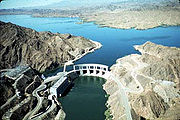
- (Lake MeadLake MeadLake Mead is the largest reservoir in the United States. It is located on the Colorado River about southeast of Las Vegas, Nevada, in the states of Nevada and Arizona. Formed by water impounded by the Hoover Dam, it extends behind the dam, holding approximately of water.-History:The lake was...
) - Lake MohaveLake MohaveLake Mohave is a reservoir formed by Davis Dam on the Colorado River, which defines the border between Nevada and Arizona in the United States. The lake lies at an elevation of near Laughlin, Nevada, Searchlight, Nevada, Cottonwood Cove, Nevada, and Bullhead City, Arizona, about downstream from...
/Davis DamDavis DamDavis Dam is a dam on the Colorado River about downstream from Hoover Dam. It stretches across the border between Arizona and Nevada. Originally called Bullhead Dam, Davis Dam was renamed after Arthur Powell Davis, who was the director of the U.S. Bureau of Reclamation from 1914 to 1932...
- Katherine Landing (Ariz)
- at TopockTopock, ArizonaTopock is a small unincorporated community in Mohave County, Arizona. Topock has a ZIP Code of 86436; in 2000, the population of the 86436 ZCTA was 1,790....
/(Needles):- Topock MarshTopock MarshThe Topock Marsh is one of the larger birdwatching sites found in the Lower Colorado River Valley, found from south of Hoover Dam to the Colorado River Delta in Mohave County, Arizona...
—Lake Havasu NWR - Beal Lake—Lake Havasu NWR
- Catfish Paradise
- Topock Marsh
- Topock Gorge—3 mi S of Topock
- Gene Wash Reservoir—Colorado River AqueductColorado River AqueductThe Colorado River Aqueduct, or CRA, is a water conveyance in Southern California in the United States, operated by the Metropolitan Water District of Southern California . The aqueduct impounds water from the Colorado River at Lake Havasu on the California-Arizona border west across the Mojave...
—at Parker Dam, CaliforniaParker Dam, CaliforniaParker Dam is an unincorporated community in San Bernardino County, California, United States. Parker Dam is located along the Colorado River across from Arizona east-northeast of Vidal. Parker Dam has a post office with ZIP code 92267. The post office opened in 1935 and closed briefly between... - Lake HavasuLake HavasuLake Havasu is a large reservoir behind Parker Dam on the Colorado River, on the border between California and Arizona. Lake Havasu City sits on the lake's eastern shore. The lake has a capacity of . The concrete arch dam was built by the United States Bureau of Reclamation between 1934 and 1938...
/Parker DamParker DamParker Dam is a concrete arch-gravity dam that crosses the Colorado River downstream of Hoover Dam. Built between 1934 and 1938 by the Bureau of Reclamation, it is high, of which are below the riverbed, making it "the deepest dam in the world". The dam's primary functions are to create a...
—BWD: Bill Williams DeltaBill Williams RiverThe Bill Williams River is a river in western-central Arizona in Mohave County; the river proper is the northern border of La Paz County which it drains in the north, as well as areas of far western Yavapai County...
—Alamo Lake is upstream on the river.- Cattail Cove/(State Park)
- Palo Verde Diversion Dam—(no lake)— 4 mi N EhrenbergEhrenberg, ArizonaEhrenberg, also historically spelled "Ehrenburg" is a census-designated place in La Paz County, Arizona, United States. The population was 1,357 at the 2000 census. Ehrenberg is named for Herman Ehrenberg ....
/BlytheBlythe, CaliforniaBlythe is a city in Riverside County, California, United States, in the "Palo Verde Valley" of the Lower Colorado River Valley region, an agricultural area and part of the Colorado Desert along the Colorado River. Blythe was named after Thomas Blythe, a gold prospector who established primary... - West flow at Palo Verde, CaliforniaPalo Verde, CaliforniaPalo Verde is a census-designated place in Imperial County, California. Palo Verde is located on the Riverside County line northeast of El Centro, The population was 171 at the 2010 census, down from 236 at the 2000 census. It is part of the 'El Centro, California Metropolitan Statistical Area'...
:- Palo Verde Lagoon, and Oxbow Lake
- Davis Lake (within Cibola National Wildlife RefugeCibola National Wildlife RefugeCibola National Wildlife Refuge is a U.S. National Wildlife Refuge in the floodplain of the lower Colorado River between Arizona and California and surrounded by a fringe of desert ridges and washes. The refuge encompasses both the historic Colorado River channel as well as a channelized portion...
)
- The following are sub-lakes, 3 to 12 miles upstream of Martinez Lake:
- Adobe Lake (Ariz)
- Taylor Lake (Calif)
- Ferguson LakeMartinez LakeMartinez Lake is a lake in the southwestern corner of the U.S. state of Arizona, about 60 miles north of Yuma, Arizona on the Lower Colorado River...
(Calif)
- Martinez LakeMartinez LakeMartinez Lake is a lake in the southwestern corner of the U.S. state of Arizona, about 60 miles north of Yuma, Arizona on the Lower Colorado River...
also with Imperial DamImperial DamThe Imperial Diversion Dam is a concrete slab and buttress, ogee weir structure across the California/Arizona border, northeast of Yuma. Completed in the 1938, the dam retains the waters of the Colorado River into the Imperial Reservoir before desilting and diversion into the All-American Canal,... - Imperial ReservoirImperial ReservoirThe Imperial Reservoir is an artificial lake formed by the construction of the Imperial Diversion Dam across the Colorado River in the Lower Colorado River Valley of Imperial County, California, and Yuma County, Arizona...
— at Imperial DamImperial DamThe Imperial Diversion Dam is a concrete slab and buttress, ogee weir structure across the California/Arizona border, northeast of Yuma. Completed in the 1938, the dam retains the waters of the Colorado River into the Imperial Reservoir before desilting and diversion into the All-American Canal,...
- Senator Wash and HillsAll-American CanalThe All-American Canal is an long aqueduct, located in southeastern California. It conveys water from the Colorado River into the Imperial Valley and to nine cities. It is the Imperial Valley's only water source, and replaced the Alamo Canal, which was located mostly in Mexico...
, and West Pond— at Imperial DamImperial DamThe Imperial Diversion Dam is a concrete slab and buttress, ogee weir structure across the California/Arizona border, northeast of Yuma. Completed in the 1938, the dam retains the waters of the Colorado River into the Imperial Reservoir before desilting and diversion into the All-American Canal,...
- Senator Wash and Hills
- Gila RiverGila RiverThe Gila River is a tributary of the Colorado River, 650 miles long, in the southwestern states of New Mexico and Arizona.-Description:...
:—extends East, with agriculture, and many riparian locales, (birdwatching). - Mittry LakeMittry LakeMittry Lake is located in the southwest corner of Arizona, just north of Yuma on the Lower Colorado River. It is located in between the upstream Imperial Dam and the downstream Laguna Dam. Mittry Lake comprises about , with much of the shoreline covered with cattails and bullrush...
at Laguna Dam - Haughtelin Lake, and Bard Lake (at Bard,Calif.)
- Morelos DamMorelos DamAfter a 1944 United States Mexico Treaty the Morelos Dam was built in 1950 across the Colorado River. It is located about below the junction of the California border and the Colorado River between the town of Los Algodones, Baja California, in northwestern Mexico and Yuma County, Arizona in the...
—(no lake) at Pilot's KnobPilot Knob (Imperial County, California)Pilot Knob is a peak in Imperial County, California.Pilot Knob is located southeast of Ogilby, It rises to an elevation of...
.
South
--Calif/Ariz
--Baja Calif-(Norte)/Sonora-(Mex)