

List of installations for 15kV AC railway electrification in Germany, Austria and Switzerland
Encyclopedia
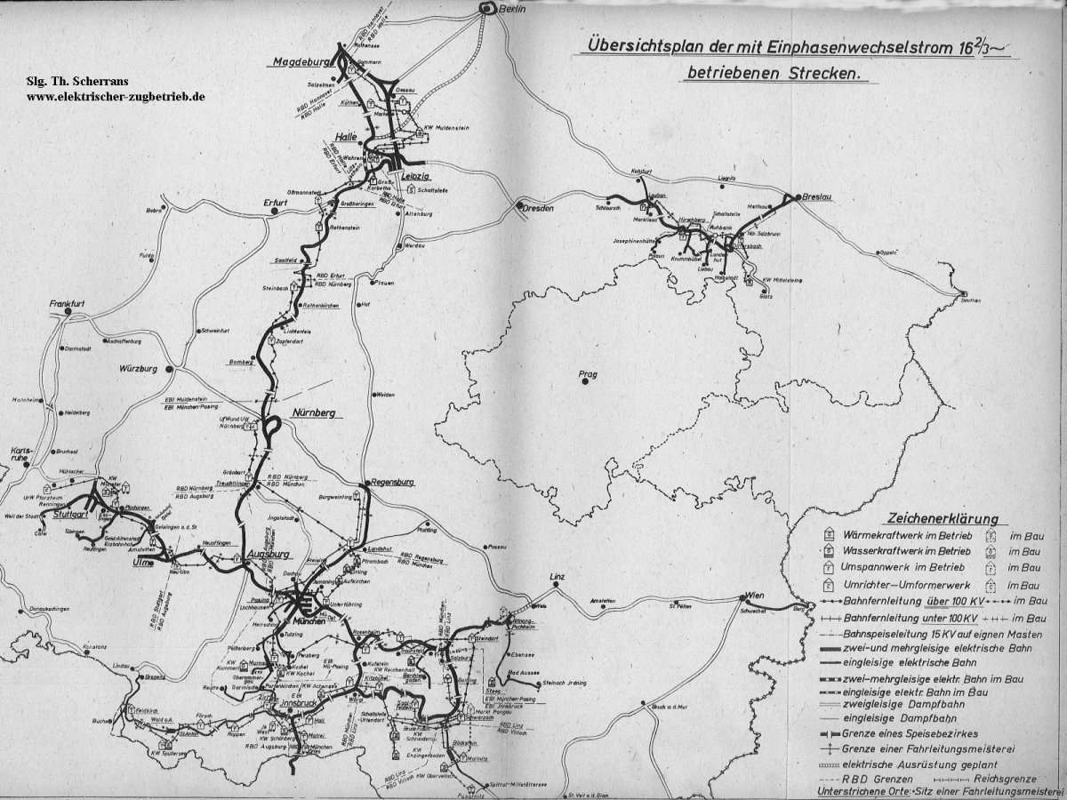
Germany, Austria and Switzerland operate the largest interconnected 15 kV AC
16.7 Hz system, which has central generation, a special transmission network, central and decentral converter plants. Source.
There is no conversion or generation of power.
At some facilities, power is also fed to the overhead wires. Conversion is made by machines or by electronic means.
There is no conversion or generation of power.
At some facilities, power is also fed to the overhead wires. Conversion is made by machines or by electronic means.
Meidling-Hütteldorf, Hütteldorf-Auhof, Hütteldorf-Florisdorf, Florisdorf-Simmering
and Meidling-Simmering, which are operated with 55 kV.
There is no conversion or generation of power.
15 kV AC
The AC railway electrification system is used in Germany, Austria, Switzerland, Sweden and Norway. The high voltage enables high power transmission with low losses powering traction motors available since the beginning of the 20th century...
16.7 Hz system, which has central generation, a special transmission network, central and decentral converter plants. Source.
Germany
In Germany, the voltage of traction current grid is 110 kV. In the Northeastern parts of Germany there is no traction current grid, as decentralized converter plants situated at the substations are used.Substations
In these facilities electricity is transformed down from 110 kV-level of DB to 15 kV.There is no conversion or generation of power.
| Facility | Coordinates |
|---|---|
| Aalen | 48°49′20"N 10°2′31"E |
| Adelsheim | 49°24′57"N 9°24′17"E |
| Almstedt | 52°1′53"N 9°56′26"E |
| Amstetten | 48°34′8"N 9°52′37"E |
| Aschaffenburg | 49°59′8"N 9°5′33"E |
| Aubing | 48°9′8"N 11°26′40"E |
| Augsburg | 48°23′54"N 10°52′0"E |
| Baden-Baden | 48°44′3"N 8°8′49"E |
| Barnstorf | 52°42′26"N 8°30′40"E |
| Bebra | 50°58′32"N 9°47′23"E |
| Bengel | 50°0′34"N 7°3′23"E |
| Biblis | 49°41′3"N 8°26′39"E |
| Bingen | 49°57′16"N 7°56′54"E |
| Böhla | 51°14′8"N 13°32′44"E |
| Boizenburg | 53°23′29"N 10°43′58"E |
| Borne | 52°6′40"N 12°32′28"E |
| Braunschweig | 52°16′9"N 10°38′24"E |
| Buchholz | 53°19′20"N 9°51′44"E |
| Burgdorf | 47°3′44"N 7°36′41"E |
| Burgweinting | 48°58′53"N 12°9′13"E |
| Datteln | 51°37′43"N 7°20′3"E |
| Denkendorf | 48°56′19"N 11°27′19"E |
| Donauwörth | 48°42′58"N 10°45′43"E |
| Dortmund | 51°30′38"N 7°24′3"E |
| Duisburg | 51°24′45"N 6°47′33"E |
| Düsseldorf | 51°13′18"N 6°50′11"E |
| Ebensfeld | 50°5′0"N 10°57′41"E |
| Eichenberg | 51°22′34"N 9°55′31"E |
| Eilenburg | 51°26′48"N 12°37′8"E |
| Eisenach | 50°57′51"N 10°22′19"E |
| Elmshorn | 53°45′45"N 9°39′17"E |
| Elsfleth | 53°16′52"N 8°28′26"E |
| Emden | 53°21′30"N 7°13′11"E |
| Emskirchen | 49°33′30"N 10°41′43"E |
| Essen | 51°27′24"N 7°1′39"E |
| Eutingen | 48°28′47"N 8°46′44"E |
| Eystrup | 52°47′32"N 9°13′45"E |
| Fallersleben | 52°25′16"N 10°40′30"E |
| Finnentrop | 51°10′3"N 7°58′1"E |
| Flieden | 50°25′8"N 9°34′18"E |
| Flörsheim | 50°0′17"N 8°24′54"E |
| Fulda | 50°32′40"N 9°41′28"E |
| Freiburg | 47°58′52"N 7°49′41"E |
| Friedberg | 50°19′28"N 8°46′25"E |
| Fronhausen | 50°41′55"N 8°41′53"E |
| Gabelbach | 48°22′45"N 10°33′35"E |
| Garssen | 52°40′30"N 10°7′44"E |
| Gemünden | 50°3′35"N 9°40′38"E |
| Geltendorf | 48°6′21"N 11°1′48"E |
| Geisenbrunn Geisenbrunn Geisenbrunn is a village in Bavaria, Germany and is located about 22 km southwest of Munich . Since 1978 it’s a part of the municipality Gilching which belongs to the district of Starnberg .- Economy and infrastructure :... |
48°6′29"N 11°19′51"E |
| Genshagener Heide | 52°20′5"N 13°16′38"E |
| Gleidingen | 52°16′1"N 9°50′6"E |
| Golm | 52°24′10"N 12°58′8"E |
| Gössnitz (old) | 50°52′36"N 12°25′10"E |
| Gössnitz (neu) | 50°54′07"N 12°25′59"E |
| Grönhart | 48°59′29"N 10°55′48"E |
| Grossheringen | 51°6′22"N 11°39′19"E |
| Grosskorbetha | 51°15′12"N 12°1′14"E |
| Güsen | 52°20′7"N 11°58′42"E |
| Hagen | 51°24′32"N 7°27′43"E |
| Halbe ( feed from 15 kV-line from Neuhof) | 52°07′00"N 13°41′31"E |
| Hameln | 52°8′26"N 9°26′43"E |
| Haren | 52°47′2"N 7°18′4"E |
| Heeren | 52°34′28"N 11°52′5"E |
| Herchen | 50°46′11"N 7°31′19"E |
| Hessental | 49°5′58"N 9°46′36"E |
| Holdingen | 47°36′19"N 7°36′40"E |
| Holzkirchen | 47°53′0"N 11°41′56"E |
| Höchst | 50°6′12"N 8°33′28"E |
| Ihringshausen | 51°21′7"N 9°32′14"E |
| Ingolstadt | 48°46′48"N 11°25′34"E |
| Kaiserslautern | 49°26′16"N 7°42′19"E |
| Karow | 52°36′29"N 13°27′30"E |
| Karthaus | 49°42′28"N 6°35′28"E |
| Kirchheim | 50°52′40"N 9°35′13"E |
| Kirchmöser | 52°22′55"N 12°24′36"E |
| Klebitz | 51°56′32"N 12°50′12"E |
| Koblenz | 50°23′12"N 7°33′52"E |
| Köln-Mülheim | 50°58′21"N 7°1′7"E |
| Körle | 51°10′51"N 9°31′48"E |
| Kreiensen | 51°50′54"N 9°58′11"E |
| Kyhna | 51°30′42"N 12°16′50"E |
| Landshut | 48°32′48"N 12°6′31"E |
| Leer | 53°12′48"N 7°27′53"E |
| Leipzig-Wahren | 51°22′55"N 12°18′47"E |
| Leonberg | 48°47′35"N 8°58′28"E |
| Limburg | 50°22′45"N 8°5′59"E |
| Löhne | 52°11′42"N 8°42′35"E |
| Lüneburg | 53°16′1"N 10°24′42"E |
| Magdeburg | 52°9′12"N 11°39′35"E |
| Mainbernheim | 49°42′0"N 10°12′39"E |
| Markt Bibart | 49°38′48"N 10°25′24"E |
| Mannheim | 49°26′27"N 8°33′43"E |
| Markt Schwaben | 48°11′6"N 11°50′59"E |
| Montabaur | 50°26′43"N 7°49′13"E |
| Mörlach | 49°11′57"N 11°14′24"E |
| Mottgers | 50°16′43"N 9°39′21"E |
| Mühlacker | 48°57′6"N 8°50′15"E |
| Muldenstein | 51°39′31"N 12°21′1"E |
| Mühlanger | 51°51′2"N 12°45′54"E |
| München-Freimann | 48°11′56"N 11°36′30"E |
| München-Ost | 48°8′13"N 11°39′2"E |
| Münster | 51°55′25"N 7°38′5"E |
| Murnau | 47°41′19"N 11°11′33"E |
| Nannhofen | 48°12′58"N 11°11′20"E |
| Neckarelz | 49°20′21"N 9°7′0"E |
| Neuhof | 52°08′03"N 13°28′49"E |
| Neumarkt (Oberpfalz) | 49°16′6"N 11°27′45"E |
| Neudittendorf | 50°54′29"N 10°53′38"E |
| Neumünster | 54°6′33"N 9°56′49"E |
| Niemberg | 51°33′33"N 12°6′10"E |
| Nörten-Hardenberg | 51°38′21"N 9°56′12"E |
| Oberacker | 49°5′23"N 8°43′55"E |
| Oberdachstetten | 49°25′3"N 10°25′31"E |
| Offenbach am Main | 50°6′13"N 8°47′17"E |
| Offenburg | 48°27′30"N 7°55′10"E |
| Orscheid | 50°39′18"N 7°19′24"E |
| Osnabrück | 52°15′56"N 8°7′4"E |
| Plattling | 48°46′49"N 12°51′8"E |
| Plochingen | 48°43′8"N 9°23′31"E |
| Pretzier | 52°49′48"N 11°16′49"E |
| Pulling | 48°22′12"N 11°42′50"E |
| Rathenow | 52°35′26"N 12°16′39"E |
| Remagen | 50°34′6"N 7°14′35"E |
| Rethen | 52°17′29"N 9°48′47"E |
| Riesa | 51°18′41"N 13°16′0"E |
| Ritterhude | 53°11′37"N 8°45′47"E |
| Rödelheim | 50°8′29"N 8°35′49"E |
| Rohrbach | 49°58′59"N 9°42′12"E |
| Röhrmoos | 48°19′24"N 11°26′49"E |
| Rosenheim | 47°50′44"N 12°7′58"E |
| Rotenburg | 53°6′26"N 9°21′17"E |
| Rottweil | 48°7′56"N 8°39′18"E |
| Rudersdorf | 50°50′4"N 8°8′58"E |
| Saalfeld | 50°38′42"N 11°22′35"E |
| Salzbergen | 52°19′42"N 7°20′39"E |
| Sindorf | 50°53′34"N 6°39′14"E |
| Singen | 47°45′29"N 8°52′54"E |
| Solpke | 52°30′2"N 11°17′43"E |
| Sommerau | 48°7′39"N 8°18′41"E |
| Steinbach am Wald | 50°26′10"N 11°22′51"E |
| Stetzsch | 51°4′35"N 13°39′36"E |
| Stolberg | 50°47′29"N 6°12′6"E |
| Stuttgart-Rohr | 48°42′50"N 9°6′35"E |
| Stuttgart-Zazenhausen | 48°50′40"N 9°11′3"E |
| Traunstein | 47°52′6"N 12°37′42"E |
| Uelzen | 52°57′50"N 10°32′37"E |
| Enz | 48°56′35"N 8°57′58"E |
| Wächtersbach | 50°14′44"N 9°17′18"E |
| Waiblingen | 48°49′31"N 9°17′51"E |
| Waigolshausen | 49°58′1"N 10°6′59"E |
| Warburg | 51°29′50"N 9°8′58"E |
| Weiterstadt | 49°54′38"N 8°34′29"E |
| Werdau | 50°43′11"N 12°22′11"E |
| Wickrath | 51°7′15"N 6°23′44"E |
| Wiesental | 49°13′19"N 8°29′48"E |
| Wolfratshausen | 47°54′30"N 11°25′32"E |
| Wörsdorf | 50°14′9"N 8°14′51"E |
| Wunstorf | 52°24′56"N 9°28′58"E |
| Würzburg | 49°48′6"N 9°53′52"E |
| Wurzen | 51°21′47"N 12°44′45"E |
| Wustermark | 52°32′26"N 12°58′25"E |
| Zapfendorf (shut down) | 50°1′33"N 10°56′29"E |
Switching stations
Switching stations without power conversion, generation or feeding of overhead wires.| Facility | Coordinates |
|---|---|
| Neckarwestheim | 49°2′34"N 9°12′6"E |
| Nenndorf | 53°22′35"N 9°54′13"E |
| Nitzahn | 52°27′35"N 12°20′45"E |
Central converter plants
In these facilities AC from the public grid is transformed into single phase AC and fed into traction current grid.At some facilities, power is also fed to the overhead wires. Conversion is made by machines or by electronic means.
| Facility | Year of inauguration | Maximum transmission rate | Used technology | Coordinates |
|---|---|---|---|---|
| Borken | 1963 | 50 MW | Rotary converter | 51°3′7"N 9°17′1"E |
| Bremen | 100 MW | GTO-Thyristor | 53°7′49"N 8°40′49"E | |
| Chemnitz | 1965 | Rotary converter | 50°51′42"N 12°56′18"E | |
| Dresden | 1977 | Rotary converter | 50°59′40"N 13°50′6"E | |
| Düsseldorf | 15 MW | GTO-Thyristor | 51°13′18"N 6°50′11"E | |
| Hamburg-Harburg | Rotary converter | 53°26′55"N 10°0′6"E | ||
| Jübek | 14 MW | GTO-Thyristor | 54°33′25"N 9°24′34"E | |
| Karlsfeld | 100 MW | GTO-Thyristor | 48°12′57"N 11°26′06"E | |
| Karlsruhe | 1957 | 53 MW | Rotary converter | 48°58′49"N 8°22′34"E |
| Köln | 1957 | 75 MW | Rotary converter | 50°54′14"N 7°2′55"E |
| Lehrte | 1963 ( rotary converter)/ 2010 ( inverter) | 37 MW ( rotary converter), 64 MW ( inverter) | Rotary converter, Inverter | 52°22′54"N 9°57′15"E |
| Limburg | 120 MW | IGCT Inverter | 50°24′20"N 8°3′58"E | |
| Marl | 1963 | 25 MW | Rotary converter | 51°39′40"N 7°10′47"E |
| Neckarwestheim | 1989 | 140 MW | Rotary converter | 49°2′22"N 9°10′40"E |
| Neckarwestheim II | 2011 | 140 MW | GTO-Thyristor | 48°2′16"N 9°10′40"E |
| Neu-Ulm | Rotary converter | 48°23′51"N 10°1′16"E | ||
| Nürnberg | Rotary converter | 49°25′48"N 11°0′18"E | ||
| Pforzheim ( shut-down) http://www.elektrische-bahnen.de/history/images/DR_elektr_Netz_1943.jpg | Rotary converter | |||
| Saarbrücken | Rotary converter | 49°14′37"N 6°58′35"E | ||
| Singen ( shut-down in 2002) | Rotary converter | 47°45′29"N 8°52′54"E | ||
| Thyrow | 2004/2005 | 8*15 = 120 MW | GTO-Thyristor | 52°14′0"N 13°18′10"E |
| Weimar | 1973 | Rotary converter | 50°59′27"N 11°20′34"E |
Decentral converter plants
In these facilities AC from the public grid is transformed into single phase AC and fed only to the overhead wires. Conversion is made by machines or by electronic means.| Facility | Year of inauguration | Maximum transmission rate | Used technology | Coordinates | |
|---|---|---|---|---|---|
| Adamsdorf | 1984 | Rotary converter | 53°24′31"N 13°2′43"E | ||
| Anklam | Rotary converter | 53°50′46"N 13°43′0"E | |||
| Berlin-Rummelsburg | 1984 | Rotary converter | 52°29′12"N 13°30′33"E | ||
| Bützow ( demolished) | Rotary converter | 53°49′30"N 11°59′3"E | |||
| Cottbus | 1989 | Rotary converter | 51°45′0"N 14°17′12"E | ||
| Doberlug-Kirchhain | 1981 (Umformer), 2008 (Inverter) | Inverter | 51°38′49"N 13°34′51"E | ||
| Eberswalde | 1987 | Rotary converter | 52°50′40"N 13°48′1"E | ||
| Falkenberg | 1987 | Rotary converter | 51°34′50"N 13°15′26"E | ||
| Oder | Rotary converter | 52°21′17"N 14°28′42"E | |||
| Lalendorf | Rotary converter | 53°45′15"N 12°23′54"E | |||
| Löwenberger Land | Rotary converter | 52°54′5"N 13°11′18"E | |||
| Ludwigsfelde | 1981 | Rotary converter | 52°18′17"N 13°16′31"E | ||
| Lübeck-Genin | 2008 | Inverter | ? | ||
| Magdeburg ( shut down) | 1974 | Rotary converter | 52°9′14"N 11°39′40"E | ||
| Neustadt (Dosse) | Rotary converter | 52°50′51"N 12°27′24"E | |||
| Oberröblingen | Rotary converter | 51°26′42"N 11°17′44"E | |||
| Prenzlau | Rotary converter | 53°19′59"N 13°52′21"E | |||
| Rosslau | Rotary converter | 51°53′51"N 12°14′29"E | |||
| Rostock | 1985 | Rotary converter | 54°3′54"N 12°8′39"E | ||
| Schwerin | 1987 | Rotary converter | 53°35′39"N 11°23′11"E | ||
| Senftenberg | 1988 | Rotary converter | 51°31′58"N 14°1′14"E | ||
| Stendal | Rotary converter | 52°35′0"N 11°52′7"E | |||
| Stralsund | Rotary converter | 54°17′9"N 13°5′23"E | |||
| Wittenberg | 1978 | Rotary converter | 51°52′30"N 12°41′20"E | ||
| Wittenberge | 1987 | Rotary converter | 52°59′46"N 11°46′8"E | ||
| Wolkramshausen | Inverter | 51°26′19"N 10°44′8"E | |||
| Wünsdorf | 1982 | Rotary converter | 52°10′24"N 13°27′42"E | ||
| Wustermark | Rotary converter | 52°32′33"N 12°58′25"E |
Power plants
| Facility | Year of inauguration | Power | Facility type | Town | Coordinates |
|---|---|---|---|---|---|
| Bad Abbach | 2000 | 3.5 MW | Hydroelectric Power Plant | Bad Abbach, Bavaria Bavaria Bavaria, formally the Free State of Bavaria is a state of Germany, located in the southeast of Germany. With an area of , it is the largest state by area, forming almost 20% of the total land area of Germany... |
48°56′47"N 12°00′47"E |
| Aschaffenburg ( shut down) | 1961-1996 | 150 MW | Coal fired power plant | Aschaffenburg, Bavaria Bavaria Bavaria, formally the Free State of Bavaria is a state of Germany, located in the southeast of Germany. With an area of , it is the largest state by area, forming almost 20% of the total land area of Germany... |
49°58′6.1"N 9°5′42.8"E |
| Aufkirchen | Hydroelectric Power Plant | Oberding, Bavaria Bavaria Bavaria, formally the Free State of Bavaria is a state of Germany, located in the southeast of Germany. With an area of , it is the largest state by area, forming almost 20% of the total land area of Germany... |
48°18′18.9"N 11°51′27.77"E | ||
| Bad Reichenhall | 1912 | 7.2 MW | Hydroelectric Power Plant | Bad Reichenhall, Bavaria | 47°43′5.36"N 12°51′47.3"E |
| Bergheim | 1970 | 23.7 MW | Hydroelectric Power Plant | Bergheim, Bavaria | 48°45′2.7"N 11°16′22.73"E |
| Bertoldsheim | 1967 | 18.9 MW | Hydroelectric Power Plant | Rennertshofen, Bavaria | 48°44′8.6"N 11°1′15"E |
| Bittenbrunn | 1969 | 20.2 MW | Hydroelectric Power Plant | Bittenbrunn, Bavaria | 48°44′4"N 11°8′37.14"E |
| Datteln | Coal fired power plant | Datteln, North Rhine-Westphalia North Rhine-Westphalia North Rhine-Westphalia is the most populous state of Germany, with four of the country's ten largest cities. The state was formed in 1946 as a merger of the northern Rhineland and Westphalia, both formerly part of Prussia. Its capital is Düsseldorf. The state is currently run by a coalition of the... |
51°37′48.16"N 7°19′52.73"E | ||
| Eitting Hydroelectric Power Plant | Hydroelectric Power Plant | Eitting, Bavaria | 48°21′32.25"N 11°52′58.07"E | ||
| Frankfurt Traction Current Power Plant | 1966 | 12 MW | Thermal Power Plant | Frankfurt am Main, Hessen | 50°05′48.88"N 8°39′5.26"E |
| Ingolstadt | 1971 | 19.8 MW | Hydroelectric Power Plant | Ingolstadt, Bavaria | 48°45′1.32"N 11°24′43.03"E |
| Kammerl | 1905 | Hydroelectric Power Plant | Saulgrub, Bavaria | 47°39′42.49"N 10°59′12.62"E | |
| Kirchmöser | 160 MW | Gas Turbine Power Plant | Brandenburg an der Havel, Brandenburg | 52°23′40.55"N 12°25′4.97"E | |
| Langenprozelten Langenprozelten Pumped Storage Station The Langenprozelten Pumped Storage Station is a pumped storage power power station near Gemünden am Main at the [Main in the under-Frankish district Main Spessart , which went in service in 1976. The hydro-electric power plant has an output of 180 MW... |
1976 | 160 MW | Hydroelectric Power Plant | Gemünden am Main, Bavaria | 50°3′11.27"N 9°34′52.87"E |
| Lausward | Coal fired power plant | Düsseldorf, North Rhine-Westphalia | 51°13′15.03"N 6°43′53.66"E | ||
| Lünen Lünen Power Station Lünen Power Station is a coal-fired power station in Germany. It's located in Lünen in the district Unna. It has an output capacity of 500 megawatts. The first power station in Lünen was commissioned in 1938. The power station produces traction current since 1984 also. Since at the end of 2003... |
1984 | 110 MW | Coal fired power plant | Lünen, North Rhine-Westphalia North Rhine-Westphalia North Rhine-Westphalia is the most populous state of Germany, with four of the country's ten largest cities. The state was formed in 1946 as a merger of the northern Rhineland and Westphalia, both formerly part of Prussia. Its capital is Düsseldorf. The state is currently run by a coalition of the... |
51°37′48.16"N 7°19′52.73"E |
| Mannheim | 1955 | 190 MW | Coal fired power plant | Mannheim, Baden-Württemberg Baden-Württemberg Baden-Württemberg is one of the 16 states of Germany. Baden-Württemberg is in the southwestern part of the country to the east of the Upper Rhine, and is the third largest in both area and population of Germany's sixteen states, with an area of and 10.7 million inhabitants... |
49°26′36.73"N 8°30′9.76"E |
| Muldenstein (retired) | 1912 | 11.3 MW | Coal fired power plant | Muldenstein, Saxony-Anhalt Saxony-Anhalt Saxony-Anhalt is a landlocked state of Germany. Its capital is Magdeburg and it is surrounded by the German states of Lower Saxony, Brandenburg, Saxony, and Thuringia.Saxony-Anhalt covers an area of... |
51°39′25.57"N 12°20′59.33"E |
| Mittelsbüren | 110 MW | Coal fired power plant | Bremen Bremen The City Municipality of Bremen is a Hanseatic city in northwestern Germany. A commercial and industrial city with a major port on the river Weser, Bremen is part of the Bremen-Oldenburg metropolitan area . Bremen is the second most populous city in North Germany and tenth in Germany.Bremen is... , Bremen |
53°7′44.33"N 8°41′0.22"E | |
| Neckarwestheim I Neckarwestheim Nuclear Power Plant Neckarwestheim Nuclear Power Station is a nuclear power plant in Neckarwestheim, Germany. It is sometimes abbreviated GKN . It is operated by EnBW Kernkraft GmbH.-GKN 1:... |
1976 | 190 MW | Nuclear Power Plant | Neckarwestheim, Baden-Württemberg | 49°2′24.41"N 9°10′19.59"E |
| Pfrombach | Hydroelectric Power Plant | Pfrombach, Bavaria | 48°26′28.94"N 11°59′34.43"E | ||
| Schkopau Power Station Schkopau Power Station The Schkopau Power Station is a lignite-fuelled power station near the Korbetha part of the municipality of Schkopau in the district of Merseburg-Querfurt , Germany, which was built in 1995/1996. It has two units with a total capacity of 916 megawatts , from which are 110 MW for traction... |
1996 | 110 MW | Coal fired power plant | Schkopau, Saxony | 51°23′54.44"N 11°57′1.17"E |
| Stuttgart-Münster Power Station ( traction current generation ceased) | 1933-1976 | Coal fired power plant | Stuttgart, Baden-Württemberg | 48°48′55.4"N 9°13′15.85"E | |
| Vohburg | Hydroelectric Power Plant | Vohburg, Bavaria | 48°46′40.5"N 11°36′4.04"E | ||
| Walchensee | 1924 | Hydroelectric Power Plant | Kochel am See, Bavaria | 47°37′47.35"N 11°20′14.8"E |
Germany - Austria
| Line | Coordinates |
|---|---|
| Walchenseekraftwerk - Zirl | 47°23′55"N 11°15′53"E |
| Traunstein - Steinsdorf | 47°53′20"N 12°58′25"E |
Former inner German border
| Line | Coordinates |
|---|---|
| Lehrte - Heeren | 52°24′48"N 10°59′34"E |
| Bebra - Weimar | 51°00′29"N 10°12′13"E |
| Steinfeld am Wald - Saalfeld | 50°27′52"N 11°25′07"E |
Points, where two powerlines for traction current crosses each other without interconnection
| Lines | Coordinates |
|---|---|
| Flieden-Bebra / Fulda-Mottgers | 50°28′55"N 9°40′52"E |
| Bebra-Borken / Kirchheim-Körle | 51°01′59"N 9°34′31"E |
| Karlsruhe-Mühlacker /Vaihingen-Graben/Neudorf | 48°56′40"N 8°48′18"E |
Switzerland
In Switzerland, the voltage levels of the traction power grid are 132 kV/66 kV. At Muttenz and Etzwilen, there are transformers for coupling to 110 kV level of the traction power grid of Germany.Substations
In these facilities electricity is transformed down from 132 kV|66 kV-level of SSB to 15 kV.There is no conversion or generation of power.
| Facility | Coordinates |
|---|---|
| Biel | 47°7′48"N 7°15′26"E |
| Brugg | 47°28′28"N 8°12′16"E |
| Bussigny | 46°32′38"N 6°33′36"E |
| Chur | 46°52′24"N 9°31′57"E |
| Courtemaîche | 47°27′21"N 7°3′20"E |
| Delémont | 47°21′49"N 7°21′30"E |
| Eglisau | 47°34′22"N 8°30′50"E |
| Emmenbrücke | 47°4′4"N 8°17′9"E |
| Etzwilen | 47°39′42"N 8°49′7"E |
| Farsch | 46°48′52"N 9°20′54"E |
| Filisur (RhB) | 46°40′19"N 9°41′36"E |
| Flüelen | 46°53′43"N 8°37′29"E |
| Fribourg | 46°48′50"N 7°9′15"E |
| Frutigen | 46°34′48"N 7°38′56"E |
| Gampel | 46°18′28"N 7°45′24"E |
| Genf-Tuleries | 46°14′59"N 6°8′48"E |
| Giornico | 46°24′5"N 8°52′23"E |
| Gland | 46°24′52"N 6°15′48"E |
| Hendschiken | 47°23′29"N 8°12′16"E |
| Kandersteg | 46°30′10"N 7°40′28"E |
| Küblis ( RhB) | 46°54′56"N 9°45′33"E |
| Melide | 45°57′59"N 8°56′54"E |
| Muttenz | 47°32′5"N 7°38′38"E |
| Neuchâtel | 46°59′25"N 6°54′56"E |
| Killwangen | 47°26′13"N 8°20′38"E |
| Olten | 47°21′40"N 7°55′20"E |
| Puidoux | 46°29′21"N 6°45′41"E |
| Rapperswil SG | 47°13′29"N 8°49′55"E |
| Rivera | 46°7′32"N 8°55′27"E |
| Roche | 46°21′52"N 6°55′28"E |
| Romont FR | 46°41′4"N 6°54′23"E |
| Rotkreuz | 47°8′42"N 8°26′27"E |
| Saglianias (RhB) | 46°45′48"N 10°5′46"E |
| Saint Léonhard | 46°15′8"N 7°25′21"E |
| Sankt Margrethen | 47°27′12"N 9°38′22"E |
| Sargans | 47°2′26"N 9°27′8"E |
| Seebach | 47°25′20"N 8°33′17"E |
| Selfranga | 46°51′23"N 9°52′56"E |
| Sihlbrugg | 47°14′34"N 8°34′37"E |
| Sils (RhB) | 46°42′8"N 9°28′8"E |
| Stein AG | 47°32′29"N 7°57′59"E |
| Steinen | 47°2′53"N 8°36′17"E |
| Tavanasa (RhB) | 46°45′17"N 9°4′15"E |
| Thun | 46°46′20"N 7°35′53"E |
| Wetzikon ZH | 47°18′35"N 8°47′56"E |
| Winterthur-Grüze | 47°30′0"N 8°45′4"E |
| Yverdon | 46°46′48"N 6°38′52"E |
| Ziegelbrücke | 47°7′59"N 9°3′55"E |
| Zürich | 47°22′52"N 8°31′19"E |
Central converter plants
In these facilities AC from the public grid is transformed into single phase AC and fed into the traction current grid.At some facilities, power is also fed to the overhead wires. Conversion is made by machines or by electronic means.
| Facility | Year of inauguration | Maximum transmission rate | Used technology | Coordinates |
|---|---|---|---|---|
| Bever (RhB) | Rotary Converter | 46°32′52"N 9°53′17"E | ||
| Landquart (RhB) | Rotary Converter | 46°58′28"N 9°33′6"E | ||
| Giubiasco | Rotary Converter | 46°10′32"N 9°0′9"E | ||
| Kerzers | Rotary Converter | 46°58′27"N 7°11′25"E | ||
| Massaboden | Rotary Converter | 46°19′55"N 8°0′42"E | ||
| Rupperswil | Rotary Converter | 47°24′21"N 8°6′19"E | ||
| Seebach | Rotary Converter | 47°25′20"N 8°33′17"E | ||
| Wimmis | Rotary Converter | 46°40′51"N 7°39′23"E |
Switching stations
Switching stations without power conversion, generation or feeding of overhead wires.| Facility | Coordinates |
|---|---|
| Zollikofen | 47°0′45"N 7°27′53"E |
Power plants
| Facility | Year of inauguration | >Power | Art der Facility | Coordinates |
|---|---|---|---|---|
| Amsteg | 1922 | 55 MW | Hydroelectric Power Plant | 46°46′2.18"N 8°40′13.6"E |
| Le Châtelard VS | Hydroelectric Power Plant | 46°3′40.94"N 6°57′29.39"E | ||
| Etzelwerk | Hydroelectric Power Plant | 47°11′39.68"N 8°48′40.04"E | ||
| Göschenen | Hydroelectric Power Plant | 46°40′2.18"N 8°35′6.81"E | ||
| Gösgen | 51,3 MW | Hydroelectric Power Plant | 47°22′8.01"N 7°58′45.92"E | |
| Klosters | Hydroelectric Power Plant | 46°51′39.62"N 9°53′44.9"E | ||
| Massaboden | 1916 | 7,2 MW | Hydroelectric Power Plant | 46°19′56.92"N 8°0′43.2"E |
| Mühleberg | 1921 | 45 MW | Hydroelectric Power Plant | 46°58′9"N 7°17′4"E |
| Ritom | 1920 | Hydroelectric Power Plant | 46°31′2.05"N 8°40′33.41"E | |
| Rupperswil | 1945 | Hydroelectric Power Plant | 47°24′42.34"N 8°6′52.66"E | |
| Vernayaz | Hydroelectric Power Plant | 46°7′59.93"N 7°2′8.8"E | ||
| Wassen | Hydroelectric Power Plant | 46°42′55.96"N 8°36′36.55"E |
Germany-Switzerland
| Leitung | Coordinates |
|---|---|
| Holdingen - Muttenz | 47°34′53"N 07°36′14"E |
| Singen - Etzwilen | 47°42′49"N 08°49′52"E |
Austria
In Austia, the voltage of traction current grid is 110 kV, except of the linesMeidling-Hütteldorf, Hütteldorf-Auhof, Hütteldorf-Florisdorf, Florisdorf-Simmering
and Meidling-Simmering, which are operated with 55 kV.
Substations
In these facilities electricity is transformed down from 110/55 kV-level of OBB to 15 kV.There is no conversion or generation of power.
| Facility | Coordinates |
|---|---|
| Absdorf | 48°23′52"N 15°59′38"E |
| Angern | 48°22′56"N 16°49′19"E |
| Amstetten (Österreich) | 48°7′9"N 14°53′7"E |
| Asten | 48°14′2"N 14°24′20"E |
| Attnang-Puchheim | 48°1′8"N 13°43′38"E |
| Bad Vöslau | 47°58′06"N 16°13′28"E |
| Bludenz | 47°8′41"N 9°49′44"E |
| Bruck Mur | 47°25′42"N 15°16′26"E |
| Dölsach | 46°48′53"N 12°49′55"E |
| Dorfgastein | 47°14′5"N 13°6′17"E |
| Elsbethen | 47°45′9"N 13°5′4"E |
| Feldkirch | 47°15′8"N 9°37′4"E |
| Floridsdorf | 48°15′42"N 16°24′19"E |
| Fritzens-Wattens | 47°18′6"N 11°35′48"E |
| Gaisbach Wartberg | 48°19′51"N 14°29′52"E |
| Golling-Abtenau | 47°35′53"N 13°9′53"E |
| Göpfritz | 48°43′48"N 15°23′29"E |
| Gries am Brenner | 47°2′36"N 11°29′9"E |
| Götzendorf | 48°1′34"N 16°34′59"E |
| Graz | 47°04′40"N 15°24′48"E |
| Haag | 48°05′33"N 14°35′36"E |
| Hohenau | |
| Hütteldorf | 48°11′43"N 16°16′17"E |
| Kitzbühel | 47°28′52"N 12°22′59"E |
| Küpfern | 47°51′9"N 14°37′3"E |
| Landeck | 47°9′8"N 10°35′11"E |
| Mallnitz | 46°58′40"N 13°10′44"E |
| Marchtrenk | 48°12′11"N 14°6′11"E |
| Mariahof | 47°06′16"N 14°22′28"E |
| Matrei | 47°7′38"N 11°27′11"E |
| Meidling | 48°10′30"N 16°20′29"E |
| Mistelbach | 48°33′51"N 16°33′33"E |
| Münster | |
| Parndorf | 47°59′45"N 16°50′33"E |
| Pettneu | 47°08′55"N 10°21′46"E |
| Pusarnitz | 46°50′5"N 13°24′17"E |
| Riedau | 48°18′31"N 13°37′37"E |
| Rohr | 48°11′15"N 15°25′47"E |
| Sankt Johann im Pongau | 47°20′10"N 13°11′23"E |
| Sankt Pölten | 48°13′55"N 15°39′19"E |
| Sankt Veit | 46°45′39"N 14°22′28"E |
| Schladming | 47°23′38"N 13°40′43"E |
| Schlöglmühl | 47°40′57"N 15°54′46"E |
| Semmering | 47°37′36"N 15°48′53"E |
| Wien-Simmering | 48°09′05"N 16°25′37"E |
| Steindorf | 47°58′0"N 13°14′24"E |
| Tulln | 48°19′24"N 16°2′37"E |
| Unterberg | 47°12′50"N 11°23′32"E |
| Villach | 46°35′42"N 13°49′55"E |
| Wald am Schoberpass | 47°27′5"N 14°40′7"E |
| Wartberg an der Krems | 47°59′21"N 14°7′18"E |
| Wegscheid | 48°14′16"N 14°16′3"E |
| Wiener Neustadt | 47°47′54"N 16°13′13"E |
| Wörgl | 47°29′58"N 12°4′19"E |
| Zellerndorf | 48°41′31"N 15°58′9"E |
| Zirl (old) | 47°15′53"N 11°13′59"E |
| Zirl (neu) | 47°15′55"N 11°13′18"E |
Central converter plants
In these facilities, AC from the public grid is transformed into single phase AC and fed into the traction current grid. At some facilities, power is also fed to overhead wires. Conversion may be performed mechanically or electronically.| Facility | Year of inauguration | Used technology | Maximum transmission rate | Coordinates |
|---|---|---|---|---|
| Auhof | 1956 | 90 MW | 48°12′00"N 16°14′12"E | |
| Bergern | 1983 | 48°13′3"N 15°16′17"E | ||
| Haiming | 1995 | 47°14′47"N 10°52′27"E | ||
| Kledering | 1989 | 48°8′21"N 16°25′56"E | ||
| Sankt Michael | 1975 | 47°21′27"N 15°0′9"E | ||
| Timelkam | 2009 | 47°59′36"N 13°35′56"E |
Power plants
| Facility | Year of inauguration | Power | Type of power plant | Coordinates |
|---|---|---|---|---|
| Annabrücke | 20 MW | Hydroelectric Power Plant | 46°33′40.77"N 14°28′46.08"E | |
| Braz | 1954 | 20 MW | Hydroelectric Power Plant | 47°7′58.19"N 9°56′43.73"E |
| Enzigerboden | 20 MW | Hydroelectric Power Plant | 47°10′10.35"N 12°37′35.9"E | |
| Fulpmes | 1983 | 15 MW | Hydroelectric Power Plant | 47°9′30.81"N 11°21′30.7"E |
| Obervellach | Hydroelectric Power Plant | 46°56′12.69"N 13°11′30.06"E | ||
| Rützkraftwerk ( Schaltposten Schönberg) | Hydroelectric Power Plant | 47°11′59.81"N 11°23′29.72"E | ||
| Sankt Pantaleon | Hydroelectric Power Plant | 48°13′29.41"N 14°31′50.85"E | ||
| Schneiderau | Hydroelectric Power Plant | 47°11′50.39"N 12°36′30.35"E | ||
| Spullersee | 1925 | 36 MW | Hydroelectric Power Plant | 47°7′58.18"N 10°3′15.76"E |
| Steeg | 1910 | Hydroelectric Power Plant (only direct fed of overhead wire) | 47°36′29.78"N 13°37′57.13"E | |
| Uttendorf | Hydroelectric Power Plant | 47°15′44.11"N 12°34′4.97"E | ||
| Weyer | Hydroelectric Power Plant | 47°51′08"N 14°38′3.49"E |
See also
- Electric power supply system of railways in NorwayElectric power supply system of railways in NorwayNorway, like Germany, Austria and Switzerland uses single phase 15 kV AC railway electrification at 16 2/3 Hz for electric train systems. However there are differences in the supply of power....
- Electric power supply system of railways in SwedenElectric power supply system of railways in SwedenElectric railways in Sweden are powered from a single-phase AC supply of 16 2/3 Hz, as used in Germany, Austria and Switzerland. Unlike these countries, the 132 kV traction current grid covers only part of the country, approximately north of Stockholm...
- List of power stations in Germany
- List of power stations in Austria
- List of power stations in Switzerland