

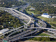
List of highways in Harris County, Texas
Encyclopedia
Harris County, Texas
As of the 2010 Census, the population of the county was 4,092,459, White Americans made up 56.6% of Harris County's population; non-Hispanic whites represented 33.0% of the population. Black Americans made up 18.9% of the population. Native Americans made up 0.7% of Harris County's population...
maintained by the Texas Department of Transportation
Texas Department of Transportation
The Texas Department of Transportation is a governmental agency in the U.S. state of Texas. Its stated mission is to "work cooperatively to provide safe, effective and efficient movement of people and goods" throughout the state...
. All state highways in Texas are paved.
Interstate Highways
| Route Name | Direction | Termini | Junctions | Length | Remarks |
|---|---|---|---|---|---|
 I-10 I-10Interstate 10 in Texas Interstate 10 is the major east–west Interstate Highway in the Southern United States. In the U.S. state of Texas, it runs east from El Paso, near the border with New Mexico, through San Antonio and Houston to the border with Louisiana in Orange, Texas.... |
E/W | Chambers County to Fort Bend County |  SH 146 SH 146Texas State Highway 146 State Highway 146, or SH 146, is a north–south highway in southeastern Texas beginning in Livingston, starting at US 59 and proceeds south to Liberty, where it meets US 90...  Beltway 8 Beltway 8 Interstate 610 Interstate 610Interstate 610 (Texas) Interstate 610 is a freeway that forms a forty-two-mile loop around the downtown sector of city of Houston, Texas. Interstate 610, colloquially known as "The Loop", "Loop 610", "The 610 Loop", or just "610", traditionally marks the border between the inner city of Houston and its surrounding areas...  US 59 US 59 Interstate 45 Interstate 45 SH 6 SH 6 SH 99 SH 99 |
Approximately 56 miles (90.1 km) | East of I-45 known locally as East Freeway. West of I-45 known locally as Katy Freeway. |
| I-45 |
S/N | Galveston County to Montgomery County |  NASA Road 1 Beltway 8 NASA Road 1 Beltway 8 SH 3 Interstate 610 US 59 Interstate 10 SH 3 Interstate 610 US 59 Interstate 10 SH 249 SH 249 |
Approximately 45 mi (72.4 km) | South of US 59 known locally as Gulf Freeway. Portion between US 59 and I-10 known locally as Pierce Elevated. North of I-10 known locally as North Freeway. |
| I-610 Interstate 610 (Texas) Interstate 610 is a freeway that forms a forty-two-mile loop around the downtown sector of city of Houston, Texas. Interstate 610, colloquially known as "The Loop", "Loop 610", "The 610 Loop", or just "610", traditionally marks the border between the inner city of Houston and its surrounding areas... |
Orbital | Officially designated from Interstate 10 east of downtown Houston, going counterclockwise. |  US 90 US 90Hardy Toll Road Hardy Toll Road The Hardy Toll Road runs from Interstate 610, near central Houston, to Interstate 45, north of Houston just below the Harris County line. The road generally parallels Interstate 45. The portion from I-610 to Crosstimbers Road is known as Spur 548, although this is unsigned.Construction on the... Interstate 45 US 290 Interstate 10 US 59 US 290 Interstate 10 US 59 Alternate US 90 Alternate US 90 SH 288 SH 288 SH 35 SH 35 SH 225 SH 225Texas State Highway 225 State Highway 225, or SH 225, is an east–west freeway in the Houston area between the Interstate 610 Loop in Houston and State Highway 146 in La Porte. It is identified as the La Porte Freeway over its entire length except for Pasadena where it is called the Pasadena Freeway... |
37.972 mi (61.11 km) | Known locally as "The Loop". |
U.S. Highways
| Route Name | Direction | Termini | Junctions | Length | Remarks |
|---|---|---|---|---|---|
| US 59 |
S/N | Fort Bend County to Montgomery County | Beltway 8 Westpark Tollway Westpark TollwayWestpark Tollway The Westpark Tollway, also Fort Bend Westpark Tollway, is a limited-access toll road serving western Houston and Harris County, and northeastern Fort Bend County. Construction on the facility began in 2001 and portions of the road were opened to traffic in May 2004. Construction of the roadway... Interstate 610 SH 288 Interstate 45 Interstate 10 |
Approximately 35 miles (56.32 km) | South of SH 288 known locally as Southwest Freeway. North of SH 288 known locally as Eastex Freeway. |
| US 90 |
E/W | Liberty County to Interstate 10 |
 FM 2100 Beltway 8 FM 2100 Beltway 8 |
Approximately 13.5 miles (21.7 km) | Freeway portion from Crosby Crosby, Texas Crosby is a census-designated place in Harris County, Texas, United States. The population was 1,714 at the 2000 census.-Geography:Crosby is located at .... to I-610 known locally as Crosby Freeway. Known locally as Beaumont Highway. Officially US 90 follows I-10 after junction, but it is unsigned. US 90 signage restarts in Katy Katy, Texas Katy is a city located in Harris, Fort Bend and Waller Counties in the U.S. state of Texas, within the Houston–Sugar Land–Baytown metropolitan area... . |
| Alternate US 90 |
N/S | Interstate 10 to Fort Bend County |
Interstate 45 SH 288 Interstate 610 Fort Bend Parkway Toll Road Fort Bend Parkway Toll RoadFort Bend Parkway Toll Road The Fort Bend Parkway Toll Road is the Fort Bend County portion of a continuous toll road connecting State Highway 6 in Missouri City in eastern Fort Bend County to US 90A in southwestern Harris County. It is administered by the Fort Bend County Toll Road Authority... Beltway 8 |
Approximately 20 miles (32 km) | Known locally as South Wayside Drive north of I-45, Old Spanish Trail between I-45 and Main Street west of SH 288, and South Main Street to Fort Bend County Line. US 90A south of I-610 is a limited-access parkway. |
 Bus. US 90-U Bus. US 90-U |
W/E | to | Beltway 8 |
8 miles (12.9 km) | Business route from Houston Houston, Texas Houston is the fourth-largest city in the United States, and the largest city in the state of Texas. According to the 2010 U.S. Census, the city had a population of 2.1 million people within an area of . Houston is the seat of Harris County and the economic center of , which is the ... to Crosby Crosby, Texas Crosby is a census-designated place in Harris County, Texas, United States. The population was 1,714 at the 2000 census.-Geography:Crosby is located at .... |
| US 290 |
E/W | I-610 to Waller County |
Beltway 8 SH 6 |
Approximately 33 miles (53.1 km) | Known locally as Northwest Freeway. |
| Bus. US 290-H |
W/E | Waller County to | 17 miles (27.4 km) | Business route through Hempstead Hempstead, Texas Hempstead is a city in Waller County, Texas, United States. The community, located at the junctions of U.S. Highway 290, Texas State Highway 6, and Texas State Highway 159, is around fifty miles northwest of Downtown Houston. The population was 4,691 at the 2000 census. It is the county seat of... , Prairie View Prairie View, Texas Prairie View is a city in Waller County, Texas, United States. The population was 4,410 at the 2000 census.Prairie View A&M University is located in the city.-Geography:Prairie View is located at .... , and Waller Waller, Texas Waller is a city in Texas, United States, partly in Waller County and partly in Harris County within the Houston–Sugar Land–Baytown metropolitan area. The population was 2,092 at the 2000 census. The Waller area is located along U.S. Highway 290 forty-one miles northwest of Downtown... ; former routing of US 290 |
|
| Bus. US 290-L |
W/E | to | 1.2 miles (1.9 km) | Business route through Cypress Cypress, Texas Cypress is an unincorporated area of Harris County, Texas, United States located completely inside the extraterritorial jurisdiction of the City of Houston. The Cypress area is located along U.S... |
State Highways
| Route Name | Direction | Termini | Junctions | Length | Remarks |
|---|---|---|---|---|---|
| SH 3 |
S/N | Galveston County to Interstate 45 |
NASA Road 1 Beltway 8 |
Approximately 8 miles (13.2 km) | Known locally as Old Galveston Road. |
| SH 6 |
S/N | Fort Bend County Fort Bend County, Texas Fort Bend County is a county located along the Gulf Coast region in the U.S. state of Texas within the Houston–Sugar Land–Baytown metropolitan area. In 2000 its population was 354,452, while the 2010 U.S... to Waller County |
Westpark Tollway FM 1093 FM 1093Farm to Market Road 1093 Farm to Market Road 1093 is a farm to market road in the U.S. state of Texas. It begins in Eagle Lake at FM 3013 and heads east to Interstate 610 in Houston. In Houston, a portion of FM 1093 is also a portion of "Westheimer Road", which continues east of I-610 without the FM 1093... US 290 FM 1960 FM 1960Farm to Market Road 1960 Farm to Market Road 1960 is a state highway in the U.S. state of Texas. Its western terminus is at an intersection with U.S... |
Approximately 30 miles (48.3 km) | Overlaps US 290 after its junction, which it follows out of the county. |
| SH 35 |
N/S | I-45 to Brazoria County |
Beltway 8 |
Approximately 6 miles (9.7 km) | Signage begins at an onramp located at Jefferson and Dowling St., and is unsigned along I-45 until it exits I-45 at Reveille Street. Known locally as Reveille Street between I-610 and Telephone Road, and known as Telephone Road from just north of Sims Bayou to Brazoria County. |
| SH 99 Segment D |
S/N | US 59 in Fort Bend County Fort Bend County, Texas Fort Bend County is a county located along the Gulf Coast region in the U.S. state of Texas within the Houston–Sugar Land–Baytown metropolitan area. In 2000 its population was 354,452, while the 2010 U.S... to Franz Road in Katy Katy, Texas Katy is a city located in Harris, Fort Bend and Waller Counties in the U.S. state of Texas, within the Houston–Sugar Land–Baytown metropolitan area... |
Westpark Tollway FM 1093 Farm to Market Road 1093 Farm to Market Road 1093 is a farm to market road in the U.S. state of Texas. It begins in Eagle Lake at FM 3013 and heads east to Interstate 610 in Houston. In Houston, a portion of FM 1093 is also a portion of "Westheimer Road", which continues east of I-610 without the FM 1093... Interstate 10 |
17.4 miles (28 km) | SH 99 is part of a proposed third freeway-grade loop around Greater Houston Greater Houston Houston–Sugar Land–Baytown is a 10-county metropolitan area defined by the Office of Management and Budget. It is located along the Gulf Coast region in the U.S. state of Texas... known as the Grand Parkway. Proposed as part of Interstate 69 expansion. Opened in 1994. |
| SH 99 Segment I-2 |
S/N | Business SH 146-E Texas State Highway 146 State Highway 146, or SH 146, is a north–south highway in southeastern Texas beginning in Livingston, starting at US 59 and proceeds south to Liberty, where it meets US 90... in Baytown Baytown, Texas Baytown is a city within Harris County and partially in Chambers County in the Gulf Coast region of the U.S. state of Texas. Located within the Houston–Sugar Land–Baytown metropolitan area, it lies along both State Highway 146 and Interstate 10. As of 2010, Baytown had an population of 71,802... to Interstate 10 near Mont Belvieu |
Interstate 10 |
Approximately 14 miles (22.5 km) | SH 99 is part of a proposed third freeway-grade loop around Greater Houston Greater Houston Houston–Sugar Land–Baytown is a 10-county metropolitan area defined by the Office of Management and Budget. It is located along the Gulf Coast region in the U.S. state of Texas... known as the Grand Parkway. Phase I of this segment open 2008, phase II in planning stages. Planned to be tolled. |
| SH 146 Texas State Highway 146 State Highway 146, or SH 146, is a north–south highway in southeastern Texas beginning in Livingston, starting at US 59 and proceeds south to Liberty, where it meets US 90... |
S/N | Galveston County to Chambers County | NASA Road 1 SH 225 Interstate 10 |
Approximately 16 miles (25.75 km) | Known in Baytown Baytown, Texas Baytown is a city within Harris County and partially in Chambers County in the Gulf Coast region of the U.S. state of Texas. Located within the Houston–Sugar Land–Baytown metropolitan area, it lies along both State Highway 146 and Interstate 10. As of 2010, Baytown had an population of 71,802... as Bob Lanier Freeway. Toll bridge over the Houston Ship Channel Houston Ship Channel The Houston Ship Channel, located in Houston, Texas, is part of the Port of Houston—one of the United States's busiest seaports. The channel is the conduit for ocean-going vessels between the Houston-area shipyards and the Gulf of Mexico.-Overview:... called the Fred Hartman Bridge Fred Hartman Bridge The Fred Hartman Bridge or Baytown Bridge is a cable-stayed bridge in the U.S. state of Texas, spanning the Houston Ship Channel. The bridge carries 2.6 miles of State Highway 146, between the cities of Baytown, Texas and La Porte, Texas... . |
| Bus. SH 146-D |
S/N | to Broadway St. | 1.8 miles (2.9 km) | Business route to La Porte La Porte, Texas La Porte is a city in Harris County, Texas within the Bay Area of the Houston–Sugar Land–Baytown metropolitan area. As of the 2000 U.S. Census, the city population was 31,880... |
|
| Bus. SH 146-E |
S/N | to | |
6.3 miles (10.1 km) | Business route through Baytown Baytown, Texas Baytown is a city within Harris County and partially in Chambers County in the Gulf Coast region of the U.S. state of Texas. Located within the Houston–Sugar Land–Baytown metropolitan area, it lies along both State Highway 146 and Interstate 10. As of 2010, Baytown had an population of 71,802... |
| SH 225 Texas State Highway 225 State Highway 225, or SH 225, is an east–west freeway in the Houston area between the Interstate 610 Loop in Houston and State Highway 146 in La Porte. It is identified as the La Porte Freeway over its entire length except for Pasadena where it is called the Pasadena Freeway... |
E/W | SH 146 to just west of Interstate 610 |
Beltway 8 Interstate 610 |
15.6 (25.1 km) | Known in Houston as La Porte Freeway and in Pasadena Pasadena, Texas Pasadena is a city in the U.S. state of Texas within the metropolitan area. It is the second-largest city in Harris County, 17th-largest in Texas, and 162nd largest in the United States. The area was founded in 1893 by John H. Burnett of Galveston.... as Paasadena Freeway. |
| SH 249 |
S/N | Interstate 45 to Montgomery County |
Beltway 8 FM 1960 |
Approximately 22 miles (35.4 km) | Portion from Beltway 8 to just south of Tomball Tomball, Texas Tomball is a city in Harris county in the U.S. state of Texas, a part of the Houston metropolitan area. The population was 9,089 at the 2000 census. In 1907, the community of Peck was renamed Tomball. The city are named for local congressman Thomas Henry Ball, who had a major role in the... is a freeway. Highway and freeway may possibly be expanded to SH 6 in Navasota Navasota, Texas Navasota is a city in Grimes County, Texas, United States. The population was 6,789 at the 2000 census. In 2005, the Texas Legislature named the city "The Blues Capital of Texas," in honor of the late Mance Lipscomb, a Navasota native and blues musician.... . |
| SH 288 |
N/S | Interstate 45 to Brazoria County |
I-45 US 59 Alternate US 90 Interstate 610 Beltway 8 |
Approximately 11 miles (17.7 km) | Known locally as South Freeway. |
| W/E | to | |
7.5 miles (12.1 km) | Main route to NASA's NASA The National Aeronautics and Space Administration is the agency of the United States government that is responsible for the nation's civilian space program and for aeronautics and aerospace research... Lyndon B. Johnson Space Center Lyndon B. Johnson Space Center The Lyndon B. Johnson Space Center is the National Aeronautics and Space Administration's center for human spaceflight training, research and flight control. The center consists of a complex of 100 buildings constructed on 1,620 acres in Houston, Texas, USA... |
State Highway Loops and Spurs
| Route Name | Direction | Termini | Junctions | Length | Remarks |
|---|---|---|---|---|---|
| Beltway 8 |
Orbital | Officially designated from Interstate 45 north of downtown Houston, going clockwise. | Hardy Toll Road Hardy Toll Road The Hardy Toll Road runs from Interstate 610, near central Houston, to Interstate 45, north of Houston just below the Harris County line. The road generally parallels Interstate 45. The portion from I-610 to Crosstimbers Road is known as Spur 548, although this is unsigned.Construction on the... US 59 US 90 Interstate 10 SH 225Texas State Highway 225 State Highway 225, or SH 225, is an east–west freeway in the Houston area between the Interstate 610 Loop in Houston and State Highway 146 in La Porte. It is identified as the La Porte Freeway over its entire length except for Pasadena where it is called the Pasadena Freeway... SH 3 Interstate 45 SH 35 SH 288 Alternate US 90 Westpark Tollway FM 1093 US 290 SH 249 |
83.128 miles (133.8 km) | Secondary loop of metro Houston, with a radius from downtown Houston of about 8 miles (12.9 km). Main lanes are part of the Sam Houston Tollway while Beltway 8 comprises the service lanes. Section between Interstate 45 and US 59 is a freeway. |
 Spur 5 Spur 5 |
N/S | Dowling Street in downtown Houston to Alternate US 90 |
2.929 miles (4.713 km) | Runs concurrent with Interstate 45 from south of downtown to Exit 44B. Freeway grade from Downling Street to University Drive. Proposed future corridor for a new SH 35 freeway. |
|
 Spur 261 Spur 261Texas State Highway Spur 261 Texas State Highway Spur 261 is a Texas State Spur in Harris County, Texas. It runs from North Loop Freeway Interstate 610, until it reaches Interstate 45.-Route description:... |
N/S | Interstate 45 to Interstate 610 |
4.611 miles (7.421 km) | Known locally as North Shepherd Dr. | |
 Spur 330 Spur 330Texas State Highway Spur 330 Spur 330 also known as Decker Dr. is a freeway spur that connects Interstate 10 to Baytown, Texas, United States.-Exit list:The entire route is in Harris County.... |
S/N | Garth Road in Baytown Baytown, Texas Baytown is a city within Harris County and partially in Chambers County in the Gulf Coast region of the U.S. state of Texas. Located within the Houston–Sugar Land–Baytown metropolitan area, it lies along both State Highway 146 and Interstate 10. As of 2010, Baytown had an population of 71,802... to Interstate 10 |
0.863 miles (1.39 km) | Short freeway-grade connector serving Baytown. Known locally as Decker Dr. | |
| S/N | Bayport Ship Channel to Bus. SH 146-D |
1.5 miles (2.4 km) | |||
 Spur 527 Spur 527Texas State Highway Spur 527 Spur 527 is a spur route in Midtown Houston in the U.S. state of Texas. The roadway is a freeway spur that feeds traffic from the Southwest Freeway into Downtown Houston.- History :... |
S/N | US 59 to Westheimer Road Westheimer Road Westheimer Road is an arterial road in the western half of Houston, Texas, United States. It runs from Bagby Street west to the Westpark Tollway. Westheimer Road runs roughly parallel to and south of Buffalo Bayou throughout its course. The street was named after Michael Louis Westheimer, a... in Houston |
0.8 miles (1.3 km) | Short freeway-grade connector serving Midtown neighborhood Midtown, Houston, Texas Midtown is a district southwest of Downtown Houston, bordered by Neartown and U.S. Highway 59.-History:Around 1906 what is now Midtown was divided between the Third Ward and Fourth Ward. Before the 1950s what is now Midtown was a popular residential district. Increasingly, commercial development... . |
|
| S/N | to Hardy Toll Road Hardy Toll Road The Hardy Toll Road runs from Interstate 610, near central Houston, to Interstate 45, north of Houston just below the Harris County line. The road generally parallels Interstate 45. The portion from I-610 to Crosstimbers Road is known as Spur 548, although this is unsigned.Construction on the... |
1.5 miles (2.4 km) | Unsigned, part of Hardy Toll Road | ||
State Park Roads
| Route Name | Direction | Termini | Junctions | Length | Remarks |
|---|---|---|---|---|---|
| S/N | Battleground Rd. to San Jacinto Battleground State Historic Site San Jacinto Battleground State Historic Site The San Jacinto Battleground State Historic Site includes the location of the Battle of San Jacinto, and the USS Texas. It is located off the Houston Ship Channel in LaPorte, Texas. The site was designated a National Historic Landmark in 1960.... |
7.2 miles (11.6 km) | With state designation canceled over Battleground Rd. (formerly SH 134), PR 1836 no longer connects to rest of state highway system; formally PR 9 |
Toll Roads
All Harris County toll roads are maintained by the Harris County Toll Road AuthorityHarris County Toll Road Authority
The Harris County Toll Road Authority maintains and operates a toll road system in the Houston/Harris County area...
.
| Route Name | Direction | Termini | Junctions | Length | Remarks |
|---|---|---|---|---|---|
| Sam Houston Tollway | Orbital | Interstate 10 east of Houston clockwise to Interstate 45 north of Houston |
SH 225 SH 3 Interstate 45 SH 35 SH 288 Fort Bend Parkway Toll Road Alternate US 90 US 59 Westpark Tollway Interstate 10 US 290 SH 249 |
Main lane portion of Beltway 8 secondary loop. The remaining portion of the loop is free. | |
| Hardy Toll Road Hardy Toll Road The Hardy Toll Road runs from Interstate 610, near central Houston, to Interstate 45, north of Houston just below the Harris County line. The road generally parallels Interstate 45. The portion from I-610 to Crosstimbers Road is known as Spur 548, although this is unsigned.Construction on the... |
S/N | Interstate 610 to Interstate 45 |
Beltway 8 FM 1960 |
21.6 miles (34.8 km) | Runs parallel to Interstate 45. Possible future expansion south to Interstate 10. |
| Westpark Tollway Westpark Tollway The Westpark Tollway, also Fort Bend Westpark Tollway, is a limited-access toll road serving western Houston and Harris County, and northeastern Fort Bend County. Construction on the facility began in 2001 and portions of the road were opened to traffic in May 2004. Construction of the roadway... |
E/W | Westpark Drive in Houston to Fort Bend County | Beltway 8 SH 6 |
14 miles (22.53 km) | Runs parallel to Westheimer Road Westheimer Road Westheimer Road is an arterial road in the western half of Houston, Texas, United States. It runs from Bagby Street west to the Westpark Tollway. Westheimer Road runs roughly parallel to and south of Buffalo Bayou throughout its course. The street was named after Michael Louis Westheimer, a... (Farm to Market Road 1093 Farm to Market Road 1093 Farm to Market Road 1093 is a farm to market road in the U.S. state of Texas. It begins in Eagle Lake at FM 3013 and heads east to Interstate 610 in Houston. In Houston, a portion of FM 1093 is also a portion of "Westheimer Road", which continues east of I-610 without the FM 1093... ). Possible future expansion east to Interstate 610. |
| Fort Bend Parkway Toll Road Fort Bend Parkway Toll Road The Fort Bend Parkway Toll Road is the Fort Bend County portion of a continuous toll road connecting State Highway 6 in Missouri City in eastern Fort Bend County to US 90A in southwestern Harris County. It is administered by the Fort Bend County Toll Road Authority... |
E/W | Alternate US 90 to Fort Bend County |
Beltway 8 |
Approximately 2 miles (3.2 km) | Runs along Hillcroft Avenue. Possible future expansion north to Interstate 610. Formerly part of SH 122 project. |
Farm and Ranch to Market Roads
| Route Name | Direction | Termini | Junctions | Length | Remarks |
|---|---|---|---|---|---|
 FM 270 FM 270Farm to Market Road 270 Farm to Market Road 270, or FM 270 or Urban Road 270 is a state highway in the U.S. state of Texas located inside the Houston–Sugar Land–Baytown metropolitan area... |
N/S | NASA Road 1 to Galveston County |
0.3 mi (0.48 km) | Known locally as Egret Bay Boulevard | |
 FM 362 FM 362 |
W/E | Waller County back to Waller County | 0.6 mi (1 km) | Concurrent with FM 1488 in very northwest corner of county. | |
| S/N | Alternate US 90 to Brazoria County |
Beltway 8 |
6.3 miles (10.1 km) | ||
 FM 525 FM 525Farm to Market Road 525 Farm to Market Road 525, or FM 525 or Urban Road 525, is a state highway entirely inside the city of Houston, Texas, United States. The road is known locally as Aldine-Bender Road.... |
E/W | US 59 to Interstate 45 |
7.054 (11.35 km) | Known locally as Aldine-Bender Road. | |
 FM 526 FM 526Farm to Market Road 526 Farm to Market Road 526, or FM 526 or Urban Road 526 , is a state highway entirely inside the city of Houston, Texas. Locally, the road is now known as Maxey Road. The road runs from I-10 north to US 90 Business.... |
S/N | I-10 Interstate 10 in Texas Interstate 10 is the major east–west Interstate Highway in the Southern United States. In the U.S. state of Texas, it runs east from El Paso, near the border with New Mexico, through San Antonio and Houston to the border with Louisiana in Orange, Texas.... to US 90 |
4.625 miles (7.443 km) | Known locally as Maxie Road. | |
 FM 528 FM 528Farm to Market Road 528 Farm to Market Road 528, or FM 528 or Urban Road 528, is a farm to market road in southeast Texas. The road runs from Interstate 45 in Webster, Texas southwest to State Highway 35C Business . FM 528 was designated on June 21, 1945; it originally ran past I-45 to State Highway 146 in Seabrook... |
E/W | to Brazoria County | Approximately 0.5 miles (0.8 km) | Known locally as Friendswood Boulevard. | |
 FM 529 FM 529Farm to Market Road 529 Farm to Market Road 529, or FM 529, is a state highway in the U.S. state of Texas. FM 529 from US 290 to the future SH 99 is technically classified as Urban Road 529 since 1995... |
E/W | US 290 to Waller County |
SH 6 |
Approximately 17 miles (27.43 km) | Sometimes referred to as Spencer Boulevard. |
 FM 865 FM 865Farm to Market Road 865 Farm to Market Road 865 is a state highway in the U.S. state of Texas within the Houston–Sugar Land–Baytown metropolitan area. Locally, the road is known as Cullen Boulevard.... |
N/S | Alternate US 90 to Brazoria County |
Interstate 610 Beltway 8 |
Approximately 9.5 miles (15.2 km) | Known locally as Cullen Boulevard. |
 FM 1092 FM 1092 |
N/S | US 59 to Fort Bend County |
Approximately 0.2 mi (0.3 km) | Known locally as Murphy Road. | |
| FM 1093 Farm to Market Road 1093 Farm to Market Road 1093 is a farm to market road in the U.S. state of Texas. It begins in Eagle Lake at FM 3013 and heads east to Interstate 610 in Houston. In Houston, a portion of FM 1093 is also a portion of "Westheimer Road", which continues east of I-610 without the FM 1093... |
E/W | Interstate 610 to Fort Bend County |
Beltway 8 SH 6 |
Approximately 13.9 miles (22.39 km) | A section of FM 1093 is also a section of Westheimer Road Westheimer Road Westheimer Road is an arterial road in the western half of Houston, Texas, United States. It runs from Bagby Street west to the Westpark Tollway. Westheimer Road runs roughly parallel to and south of Buffalo Bayou throughout its course. The street was named after Michael Louis Westheimer, a... |
| E/W | Montgomery County to Huffman Cleveland Rd. | 1.1 miles (1.8 km) | |||
 FM 1488 FM 1488Farm to Market Road 1488 Farm to Market Road 1488, or FM 1488, is a state highway in the U.S. state of Texas. Its western terminus is at an intersection with Business U.S. Highway 290 in Hempstead and travels east-northeast, ending at Interstate 45 between The Woodlands and Conroe... |
W/E | Waller County back to Waller County | 0.6 mi (1 km) | Concurrent with FM 362 in very northwest corner of county. | |
 FM 1736 FM 1736 |
N/S | Waller County back to Waller County | 0.5 mi (0.8 km) | Runs in very northwest corner of county. | |
 FM 1876 FM 1876 |
N/S | Bellaire Blvd. in Alief Alief, Houston, Texas Alief is a community in Harris County, Texas, United States that is mostly within the city limits of Houston. The Alief Community Association defines the boundaries of Alief as, "Westheimer on the north, Sam Houston Tollway on the east, Fort Bend County Line on the west and Highway 59 on the... to Fort Bend County |
2.2 miles (3.54 km) | Known locally as Synott Road. | |
 FM 1942 FM 1942 |
E/W | Chambers County to US 90 |
8.4 miles (13.52 km) | Known locally as Crosby-Cedar Bayou Road. | |
 FM 1959 FM 1959Farm to Market Road 1959 Farm to Market Road 1959 is a state highway in southeast Harris County in the U.S. state of Texas within the Houston–Sugar Land–Baytown metropolitan area.The road, known locally as Dixie Farm Road, is a very short road at... |
W/E | Interstate 45 to State Highway 3 |
1.339 miles (2.155 km) | Known locally as Dixie Farm to Market Road. | |
| FM 1960 Farm to Market Road 1960 Farm to Market Road 1960 is a state highway in the U.S. state of Texas. Its western terminus is at an intersection with U.S... |
W/E | US 290 to Liberty County |
SH 249 Interstate 45 Hardy Toll Road Hardy Toll Road The Hardy Toll Road runs from Interstate 610, near central Houston, to Interstate 45, north of Houston just below the Harris County line. The road generally parallels Interstate 45. The portion from I-610 to Crosstimbers Road is known as Spur 548, although this is unsigned.Construction on the... US 59 |
Approximately 39 miles (62.7 km) | Long thoroughfare through northern suburbs of Houston. |
 Bus. FM 1960-A Bus. FM 1960-A |
W/E | to |
4.124 miles (6.637 km) | Business route through Humble Humble, Texas Humble is a city in Harris County, Texas within the Houston–Sugar Land–Baytown metropolitan area.As of the 2000 census, the city population was 14,579. The city shares a zip code with the small Houston neighborhood of Bordersville, although people who live in Bordersville still have Humble... |
|
| FM 2100 Farm to Market Road 2100 Farm to Market Road 2100 is a north to south highway that goes from Huffman, Texas to Barrett, Texas . Formed in 1953 the road is long and the portion from US Route 90 to Farm to Market Road 1960 is officially Urban Road 2100. The northern terminus is Huffman-Cleveland Road and the southern... |
S/N | US 90 to  FM 1485 FM 1485 |
FM 1960 US 90/Crosby Freeway Business US 90-U Business US 90-U |
14.285 miles (23 km) | Known locally as Crosby-Huffman Road. |
 FM 2351 FM 2351 |
W/E | Galveston County to SH 3 |
Interstate 45 |
Approximately 1 mile (1.6 km) | Known locally as Edgewood Drive. |
 FM 2553 FM 2553 |
W/E | Interstate 45 to SH 3 |
1.152 mi (1.85 km) | Known locally as Scarsdale Boulevard. | |
 FM 2920 FM 2920Farm to Market Road 2920 Farm to Market Road 2920 is a state highway in northwest Harris County in the U.S. state of Texas within the Houston – Sugar Land – Baytown metropolitan area.The road, also called Waller–Tomball Road, passes from U.S... |
W/E | Business US 290 to Interstate 45 |
SH 249 |
30.849 km (49.65 km) | Sometimes referred to as Waller-Tomball Road. |
 FM 2978 FM 2978Farm to Market Road 2978 Farm to Market Road 2978 is a farm to market road in Harris and Montgomery counties, Texas.-Route description:The southern terminus of FM 2978 is at just east of the Tomball city limits. The road travels north along Hufsmith–Kohrville Road, through the community of Hufsmith and along the western... |
S/N | FM 2920 to Montgomery County |
Approximately 3.5 miles (5.63 km) | Known locally as Huffsmith-Conroe Road. |
Adjacent counties
- Montgomery County (north)
- Liberty County (northeast)
- Chambers County (east)
- Galveston County (southeast)
- Brazoria County (south)
- Fort Bend County (southwest)
- Waller County (northwest)