
List of airports in the Netherlands Antilles
Encyclopedia
This is a list of airport
s in the former Netherlands Antilles
upon its dissolution in 2010, sorted by location.
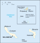
The Netherlands Antilles were part of the Lesser Antilles
and consisted of two groups of islands in the Caribbean Sea
: Bonaire and Curaçao
(off the Venezuela
n coast), and Saba, Sint Eustatius and Sint Maarten (located southeast of the Virgin Islands
). The islands formed an autonomous part of the Kingdom of the Netherlands
until the dissolution of the Netherlands Antilles in 2010.
Airport
An airport is a location where aircraft such as fixed-wing aircraft, helicopters, and blimps take off and land. Aircraft may be stored or maintained at an airport...
s in the former Netherlands Antilles
Netherlands Antilles
The Netherlands Antilles , also referred to informally as the Dutch Antilles, was an autonomous Caribbean country within the Kingdom of the Netherlands, consisting of two groups of islands in the Lesser Antilles: Aruba, Bonaire and Curaçao , in Leeward Antilles just off the Venezuelan coast; and Sint...
upon its dissolution in 2010, sorted by location.
The Netherlands Antilles were part of the Lesser Antilles
Lesser Antilles
The Lesser Antilles are a long, partly volcanic island arc in the Western Hemisphere. Most of its islands form the eastern boundary of the Caribbean Sea with the Atlantic Ocean, with the remainder located in the southern Caribbean just north of South America...
and consisted of two groups of islands in the Caribbean Sea
Caribbean Sea
The Caribbean Sea is a sea of the Atlantic Ocean located in the tropics of the Western hemisphere. It is bounded by Mexico and Central America to the west and southwest, to the north by the Greater Antilles, and to the east by the Lesser Antilles....
: Bonaire and Curaçao
Curaçao
Curaçao is an island in the southern Caribbean Sea, off the Venezuelan coast. The Country of Curaçao , which includes the main island plus the small, uninhabited island of Klein Curaçao , is a constituent country of the Kingdom of the Netherlands...
(off the Venezuela
Venezuela
Venezuela , officially called the Bolivarian Republic of Venezuela , is a tropical country on the northern coast of South America. It borders Colombia to the west, Guyana to the east, and Brazil to the south...
n coast), and Saba, Sint Eustatius and Sint Maarten (located southeast of the Virgin Islands
Virgin Islands
The Virgin Islands are the western island group of the Leeward Islands, which are the northern part of the Lesser Antilles, which form the border between the Caribbean Sea and the Atlantic Ocean...
). The islands formed an autonomous part of the Kingdom of the Netherlands
Kingdom of the Netherlands
The Kingdom of the Netherlands is a sovereign state and constitutional monarchy with territory in Western Europe and in the Caribbean. The four parts of the Kingdom—Aruba, Curaçao, the Netherlands, and Sint Maarten—are referred to as "countries", and participate on a basis of equality...
until the dissolution of the Netherlands Antilles in 2010.
List
| Island Islands of the Netherlands Antilles ||The Netherlands Antilles were divided into six administrative divisions, the island territories :, including an islet called Klein Bonaire , including an islet called Klein Curaçao , the southern half of Saint Martin island .Aruba seceded from the... (City) |
ICAO ICAO airport code The ICAO airport code or location indicator is a four-character alphanumeric code designating each airport around the world. These codes are defined by the International Civil Aviation Organization, and published in ICAO Document 7910: Location Indicators.The ICAO codes are used by air traffic... |
IATA IATA airport code An IATA airport code, also known an IATA location identifier, IATA station code or simply a location identifier, is a three-letter code designating many airports around the world, defined by the International Air Transport Association... |
Airport name | Coordinates |
| Bonaire (Kralendijk Kralendijk Kralendijk is the capital city and main port of the island of Bonaire in the Caribbean Netherlands. The language spoken in the town is Papiamentu, but Dutch and English are widely used. In Dutch, Kralendijk means "coral reef" or "coral dike". The Papiamentu name for the town is Playa or "beach"... ) |
TNCB | BON | Flamingo International Airport Flamingo International Airport Flamingo International Airport or Bonaire International Airport is an international airport located at Kralendijk, Bonaire, Netherlands. The Flamingo Airport serves as a connecting point for flights of KLM to some airports in South America... |
12°07′51"N 068°16′06"W |
| Curaçao Curaçao Curaçao is an island in the southern Caribbean Sea, off the Venezuelan coast. The Country of Curaçao , which includes the main island plus the small, uninhabited island of Klein Curaçao , is a constituent country of the Kingdom of the Netherlands... (Willemstad Willemstad, Netherlands Antilles Willemstad is the capital city of Curaçao, an island in the southern Caribbean Sea that forms a constituent country of the Kingdom of the Netherlands. Formerly the capital of the Netherlands Antilles prior to its dissolution in 2010, it has an estimated population of 140,000. The historic centre of... ) |
TNCC | CUR | Hato International Airport Hato International Airport Hato International Airport or Curaçao International Airport is the airport of Willemstad, Curaçao. It has services to the Caribbean region, South America, North America and Europe... |
12°11′19"N 068°57′35"W |
| Saba | TNCS | SAB | Juancho E. Yrausquin Airport Juancho E. Yrausquin Airport -External links:* - local airline* * of J. Irausquin Airport from Airliners* from YouTube* from World Airport Codes... |
17°38′43"N 063°13′14"W |
| Sint Eustatius | TNCE | EUX | F.D. Roosevelt Airport F.D. Roosevelt Airport F.D. Roosevelt Airport is the airport located on the island of Sint Eustatius, Caribbean Netherlands. It was opened as "Golden Rock Airport" in 1946... |
17°29′47"N 062°58′45"W |
| Saint Maarten (Philipsburg Philipsburg, Netherlands Antilles Philipsburg is the main town and capital of the country of Sint Maarten, on a narrow stretch of land between Great Bay and the Great Salt Pond. It functions as the commercial center of Saint Martin island, whereof Sint Maarten encompasses the southern half... ) |
TNCM | SXM | Princess Juliana International Airport Princess Juliana International Airport Princess Juliana International Airport serves the Dutch part of the island of Sint Maarten. In 2007, the airport handled 1,647,824 passengers and 103,650 aircraft movements. The airport serves as a hub for Windward Islands Airways and is the major gateway for the smaller Leeward Islands,... |
18°02′27"N 063°06′32"W |
See also
- List of airports by ICAO code: T#Netherlands Antilles
- List of airports in Aruba (part of the Netherlands Antilles until 1986)
- Transportation in the Netherlands Antilles
- Wikipedia: WikiProject Aviation/Airline destination lists: North America#Netherlands Antilles
External links
- Lists of airports in the Netherlands Antilles: