
List of South Carolina rivers
Encyclopedia
By drainage basinDrainage basinA drainage basin is an extent or an area of land where surface water from rain and melting snow or ice converges to a single point, usually the exit of the basin, where the waters join another waterbody, such as a river, lake, reservoir, estuary, wetland, sea, or ocean...
This list is arranged by drainage basin, from north to south, with respective tributaries indented under each larger stream's name. All rivers in South Carolina drain to the Atlantic OceanAtlantic Ocean
The Atlantic Ocean is the second-largest of the world's oceanic divisions. With a total area of about , it covers approximately 20% of the Earth's surface and about 26% of its water surface area...
.
- Little River
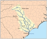
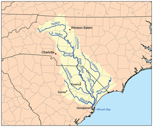
- Pee Dee RiverPee Dee RiverThe Pee Dee River, also known as the Great Pee Dee River, is a river in North Carolina and South Carolina. It originates in the Appalachian Mountains in North Carolina, where its upper course above the mouth of the Uwharrie River is known as the Yadkin River. It is extensively dammed for flood...
- Sampit RiverSampit RiverThe Sampit River begins in a swampy area of western Georgetown County, South Carolina, USA. It flows in an easterly direction to Winyah Bay at Georgetown. Only small crafts can navigate the upper parts of the river...
- Sampit River
-
- Little Pee Dee RiverLittle Pee Dee RiverThe Little Pee Dee River is a tributary of the Pee Dee River . The Little Pee Dee technically arises near Laurinburg, North Carolina as Gum Swamp, which flows southward, receiving several small tributaries, across the South Carolina border into Red Bluff Lake, near McColl, South Carolina...
- Lumber RiverLumber RiverThe Lumber River is a river in south-central North Carolina in the flat Coastal Plain. European settlers first called the river Drowning Creek, which still is the name of its headwater. The waterway known as the Lumber River extends downstream from the Scotland County-Hoke County border to the...
- Lumber River
- Lynches RiverLynches RiverLynches River, named for Thomas Lynch, Jr., signer of the Declaration of Independence, rises in North Carolina near Waxhaw, North Carolina, at about 700 feet elevation, flowing only a short distance to the South Carolina border, and thence to join the Pee Dee River nearJohnsonville...
- Little River
- Jeffries CreekJeffries CreekJeffries Creek is a tributary of the Great Pee Dee River in South Carolina. Its headwaters begin just south of Hartsville, South Carolina. It flows through Darlington and Florence counties. The principal significance of this body of water is that it traverses the city of Florence, South Carolina...
- Black Creek
- Little Pee Dee River
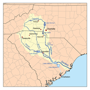
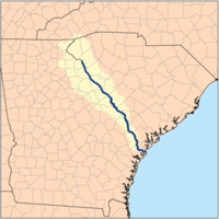
- Santee RiverSantee RiverThe Santee River is a river in South Carolina in the United States, long. The Santee and its tributaries provide the principal drainage and navigation for the central coastal plain of South Carolina, emptying into the Atlantic Ocean approximately from its farthest headwater on the Catawba River...
(North Santee River and South Santee River are distributaries)- Little River
- Wateree RiverWateree RiverThe Wateree River, about 75 mi long, is a tributary of the Santee River in central South Carolina in the United States, which flows to the Atlantic Ocean...
- Catawba RiverCatawba RiverThe Catawba River is a tributary of the Wateree River in the U.S. states of North Carolina and South Carolina. The river is approximately 220 miles long...
- Fishing Creek
- Catawba River
- Congaree RiverCongaree RiverThe Congaree River is a short but wide river in South Carolina in the United States; It flows for only 47 miles . The river serves an important role as the final outlet channel for the entire Lower Saluda and Lower Broad watersheds, before merging with the Wateree River just north of Lake Marion to...
- Broad RiverBroad River (Carolinas)The Broad River is a principal tributary of the Congaree River, about 150 miles long, in western North Carolina and northern South Carolina in the United States. Via the Congaree, it is part of the watershed of the Santee River, which flows to the Atlantic Ocean...
- Little RiverLittle River (Broad River)The Little River is a tributary of the Broad River flowing through Fairfield County, South Carolina and forming a small portion of Fairfield's border with Richland County.-References:1. http://www.mapquest.com/maps?city=Jenkinsville&state=SC...
- Enoree RiverEnoree RiverThe Enoree River is a tributary of the Broad River, 85 mi long, in northwestern South Carolina in the United States . Via the Broad and Congaree Rivers, it is part of the watershed of the Santee River, which flows to the Atlantic Ocean ....
- Tyger River
- Fairforest Creek
- North Tyger River
- Middle Tyger River
- South Tyger River
- Sandy RiverSandy River (South Carolina)The Sandy River and its tributary the Little Sandy River are short rivers in north-central South Carolina in the United States. The Sandy is a tributary of the Broad River; via the Broad and Congaree Rivers, it is part of the watershed of the Santee River, which flows to the Atlantic Ocean .The...
- Little Sandy River
- Pacolet RiverPacolet RiverThe Pacolet River is a tributary of the Broad River, about 50 miles long, in northwestern South Carolina in the United States . One of its principal headwaters tributaries also drains a small portion of western North Carolina. Via the Broad and Congaree Rivers, it is part of the watershed of the...
- Lawsons Fork CreekPacolet RiverThe Pacolet River is a tributary of the Broad River, about 50 miles long, in northwestern South Carolina in the United States . One of its principal headwaters tributaries also drains a small portion of western North Carolina. Via the Broad and Congaree Rivers, it is part of the watershed of the...
- North Pacolet RiverPacolet RiverThe Pacolet River is a tributary of the Broad River, about 50 miles long, in northwestern South Carolina in the United States . One of its principal headwaters tributaries also drains a small portion of western North Carolina. Via the Broad and Congaree Rivers, it is part of the watershed of the...
- South Pacolet RiverPacolet RiverThe Pacolet River is a tributary of the Broad River, about 50 miles long, in northwestern South Carolina in the United States . One of its principal headwaters tributaries also drains a small portion of western North Carolina. Via the Broad and Congaree Rivers, it is part of the watershed of the...
- Lawsons Fork Creek
- Little River
- Saluda RiverSaluda RiverThe Saluda River is a principal tributary of the Congaree River, about 200 mi long, in northern and western South Carolina in the United States...
- Little Saluda River
- Bush RiverBush River (South Carolina)The Bush River is a tributary of the Saluda River, 30 mi long, in the Piedmont region of western South Carolina in the United States. Via the Saluda and Congaree Rivers, it is part of the watershed of the Santee River, which flows to the Atlantic Ocean....
- Little River
- Reedy RiverReedy RiverThe Reedy River is a tributary of the Saluda River, about long, in northwestern South Carolina in the United States. Via the Saluda and Congaree Rivers, it is part of the watershed of the Santee River, which flows to the Atlantic Ocean....
- North Saluda RiverSaluda RiverThe Saluda River is a principal tributary of the Congaree River, about 200 mi long, in northern and western South Carolina in the United States...
- South Saluda RiverSaluda RiverThe Saluda River is a principal tributary of the Congaree River, about 200 mi long, in northern and western South Carolina in the United States...
- Oolenoy RiverOolenoy RiverThe Oolenoy River is a minor tributary of the Saluda River sourced near Sassafras Mountain in northern Pickens County, South Carolina. Approximately 37 miles in length, it empties into the South Fork Saluda River near the Pumpkintown Community. It is part of the Santee River System....
- Oolenoy River
- Broad River
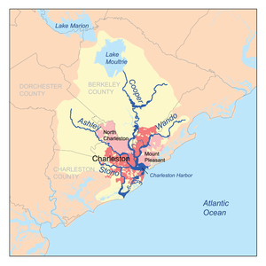
- Wando RiverWando RiverThe Wando River is a tidewater river in the coastal area of South Carolina. It begins in the town of Awendaw and empties into the Cooper River at Charleston Harbor. Its drainage area is . -External links:...
- Cooper RiverCooper River (South Carolina)The Cooper River is a mainly tidal river in the U.S. state of South Carolina. These cities are located along the river, Mt. Pleasant, Charleston, North Charleston, Goose Creek and Hanahan. Short and wide, it is joined first by the blackwater East Branch, then farther downstream, the tidal Wando River...
- Back RiverCooper River (South Carolina)The Cooper River is a mainly tidal river in the U.S. state of South Carolina. These cities are located along the river, Mt. Pleasant, Charleston, North Charleston, Goose Creek and Hanahan. Short and wide, it is joined first by the blackwater East Branch, then farther downstream, the tidal Wando River...
- Back River
- Ashley RiverAshley River (South Carolina)The Ashley River is a blackwater / tidal river in South Carolina, rising from the Wassamassaw and Great Cypress Swamps in western Berkeley County. It consolidates its main channel about five miles west of Summerville, widening into a tidal estuary just south of Fort Dorchester...
- Stono RiverStono RiverThe Stono River is a tidal channel in southeast South Carolina, located southwest of Charleston. The channel runs southwest to northeast between the mainland and Wadmalaw Island and Johns Island, from north Edisto River between Johns and James Island. The Intracoastal Waterway runs through...
- Kiawah River
- Edisto RiverEdisto RiverThe Edisto River is the longest completely undammed / unleveed blackwater river in North America, flowing 206 meandering miles from its sources in Saluda and Edgefield counties, to its Atlantic Ocean mouth at Edisto Beach, SC...
(North Edisto River and South Edisto River are distributaries)- Four Holes SwampFour Holes SwampFour Holes Swamp is a small blackwater river that is a tributary to the Edisto River in South Carolina. The swamp rises in Calhoun County and flows to the confluence, in an unusual braided pattern; it has no well-defined channel, but multiple channels that start and disappear, yet maintain a...
- North Fork Edisto RiverEdisto RiverThe Edisto River is the longest completely undammed / unleveed blackwater river in North America, flowing 206 meandering miles from its sources in Saluda and Edgefield counties, to its Atlantic Ocean mouth at Edisto Beach, SC...
- South Fork Edisto RiverEdisto RiverThe Edisto River is the longest completely undammed / unleveed blackwater river in North America, flowing 206 meandering miles from its sources in Saluda and Edgefield counties, to its Atlantic Ocean mouth at Edisto Beach, SC...
- Little River
- Four Holes Swamp
- Ashepoo RiverAshepoo RiverAshepoo River is a short blackwater river in South Carolina. It rises in a confluence of swamps south of Walterboro, flows in southeast direction and then empties into Saint Helena Sound at . The entire course of the river lies within the boundaries of Colleton County...
- Combahee RiverCombahee RiverThe Combahee River is a short blackwater river in the southern Lowcountry region of South Carolina formed at the confluence of the Salkehatchie and Little Salkehatchie rivers near the Islandton community of Colleton County, South Carolina...
- Little Salkehatchie RiverLittle Salkehatchie RiverThe Little Salkehatchie River originates in the Town of Blackville, South Carolina and accepts drainage fromLake Cynthia, Guess Pond, Brooker Pond, Ghants Branch, Halfmoon Branch, and Long Gall Branch....
- Salkehatchie RiverSalkehatchie RiverThe Salkehatchie River originates near the City of Barnwell, South Carolina and accepts drainage from Turkey Creek and Whippy Swamp before merging with the Little Salkehatchie River to form the Combahee River Basin, which empties into Saint Helena Sound and the Atlantic Ocean...
- Little Salkehatchie River
- Coosaw River
- Morgan RiverMorgan RiverThe Morgan River is a river of the West Coast Region of New Zealand's South Island. It flows generally west from the small Lake Morgan, high in the Kaimata Range of the Southern Alps, reaching the Crooked River 18 kilometres from the latters outflow into Lake Brunner.-References:...
- Story River
- Beaufort River
- Broad RiverBroad River (South Carolina)The Broad River is a tidal channel, in Beaufort and Jasper County, South Carolina. The channel flows between mainland on the west and Port Royal and Parris Islands on the east. The Coosawhatchie River flows into the Broad River at the head. It joins Coosaw River channel Northeast and continues...
- Colleton River
- Pocotaligo River
- Coosawhatchie RiverCoosawhatchie RiverThe Coosawhatchie River is a river in the U.S. state of South Carolina. It rises in Allendale County near the towns of Allendale and Fairfax and accepts drainage from Swallow Savanna, Harters Pond, Little Duck Branch, Duck Branch, Beech Branch , Blood Hill Creek, and Cedar Branch. The channel...
- May RiverMay RiverThe May River is a river in the Kimberley of Western Australia.The river is formed when the Lennard River splits into two channels just North of Mount Marmion and near the Kimberley Downs Station homestead, the other channel being the Meda River...
- New River
- Wright River
- Savannah RiverSavannah RiverThe Savannah River is a major river in the southeastern United States, forming most of the border between the states of South Carolina and Georgia. Two tributaries of the Savannah, the Tugaloo River and the Chattooga River, form the northernmost part of the border...
- Stevens Creek
- Little River
- Rocky RiverRocky River (South Carolina)The Rocky River is a tributary of the Savannah River in the U.S. state of South Carolina. It flows into the Savannah River just west of Calhoun Falls at . It forms as the confluence of Beaverdam Creek and Little Beaverdam Creek northeast of Anderson at ....
- Seneca River
- Keowee RiverKeowee RiverThe Keowee River is created by the confluence of the Toxaway River and the Whitewater River in northern Oconee County, South Carolina. The confluence is today submerged beneath the waters of Lake Jocassee, a reservoir created by Lake Jocassee Dam....
- Little River
- Flat Shoals River
- Toxaway RiverToxaway RiverThe Toxaway River is a waterway that flows south from headwaters in Transylvania County, North Carolina, into Lake Toxaway and over Toxaway Falls, after which it crosses into South Carolina and enters Lake Jocassee, the reservoir behind Lake Jocassee Dam....
- Horsepasture RiverHorsepasture RiverThe Horsepasture River is an National Wild and Scenic river in the U.S. states of North Carolina and South Carolina. The river rises in Jackson County, North Carolina, and flows through the Jocassee Gorges area and ends at Lake Jocassee in South Carolina...
- Horsepasture River
- Whitewater RiverWhitewater River (Keowee River)The Whitewater River is a river that flows south from headwaters in Transylvania County, North Carolina, over Upper Whitewater Falls and Lower Whitewater Falls before crossing into South Carolina and entering Lake Jocassee, the reservoir behind Lake Jocassee Dam.In Lake Jocassee the Whitewater...
- Thompson River
- Little River
- Keowee River
- Tugaloo RiverTugaloo RiverThe Tugaloo River is a river bordering the U.S. states of Georgia and South Carolina. It is fed by the Tallulah River and the Chattooga River, which each form an arm of Lake Tugalo, on the edge of Georgia's Tallulah Gorge State Park. The Tugaloo then flows out of the lake via Tugaloo Dam,...
- Chauga RiverChauga RiverThe Chauga River is a tributary of the Tugaloo River in Oconee County, South Carolina.-Course:The Chauga River's source is the confluence of Village Creek and East Village Creek about south of Mountain Rest, South Carolina, in the Andrew Pickens Ranger District of the Sumter National Forest...
- Chattooga RiverChattooga RiverThe Chattooga River is the main tributary of the Tugaloo River. Its headwaters are located southwest of Cashiers, North Carolina, and it stretches to where it has its confluence with the Tallulah River within Lake Tugalo, held back by the Tugalo Dam...
- East Fork Chattooga River
- Chauga River
Alphabetically
- Ashepoo RiverAshepoo RiverAshepoo River is a short blackwater river in South Carolina. It rises in a confluence of swamps south of Walterboro, flows in southeast direction and then empties into Saint Helena Sound at . The entire course of the river lies within the boundaries of Colleton County...
- Ashley RiverAshley River (South Carolina)The Ashley River is a blackwater / tidal river in South Carolina, rising from the Wassamassaw and Great Cypress Swamps in western Berkeley County. It consolidates its main channel about five miles west of Summerville, widening into a tidal estuary just south of Fort Dorchester...
- Beaufort River
- Black RiverBlack River (South Carolina)The Black River is a blackwater river in South Carolina in the United States....
- Black Mingo CreekBlack Mingo CreekBlack Mingo Creek is a tributary to the Black River in coastal South Carolina. It derives its name from mingo or minko, the Chickasaw word for chief. This area was a special hunting ground and a center of the eastern Chickasaw in colonial times....
- Broad RiverBroad River (Carolinas)The Broad River is a principal tributary of the Congaree River, about 150 miles long, in western North Carolina and northern South Carolina in the United States. Via the Congaree, it is part of the watershed of the Santee River, which flows to the Atlantic Ocean...
(northern) - Broad RiverBroad River (South Carolina)The Broad River is a tidal channel, in Beaufort and Jasper County, South Carolina. The channel flows between mainland on the west and Port Royal and Parris Islands on the east. The Coosawhatchie River flows into the Broad River at the head. It joins Coosaw River channel Northeast and continues...
(southern) - Bush RiverBush River (South Carolina)The Bush River is a tributary of the Saluda River, 30 mi long, in the Piedmont region of western South Carolina in the United States. Via the Saluda and Congaree Rivers, it is part of the watershed of the Santee River, which flows to the Atlantic Ocean....
- Catawba RiverCatawba RiverThe Catawba River is a tributary of the Wateree River in the U.S. states of North Carolina and South Carolina. The river is approximately 220 miles long...
- Chattooga RiverChattooga RiverThe Chattooga River is the main tributary of the Tugaloo River. Its headwaters are located southwest of Cashiers, North Carolina, and it stretches to where it has its confluence with the Tallulah River within Lake Tugalo, held back by the Tugalo Dam...
- Chauga RiverChauga RiverThe Chauga River is a tributary of the Tugaloo River in Oconee County, South Carolina.-Course:The Chauga River's source is the confluence of Village Creek and East Village Creek about south of Mountain Rest, South Carolina, in the Andrew Pickens Ranger District of the Sumter National Forest...
- Combahee RiverCombahee RiverThe Combahee River is a short blackwater river in the southern Lowcountry region of South Carolina formed at the confluence of the Salkehatchie and Little Salkehatchie rivers near the Islandton community of Colleton County, South Carolina...
- Congaree RiverCongaree RiverThe Congaree River is a short but wide river in South Carolina in the United States; It flows for only 47 miles . The river serves an important role as the final outlet channel for the entire Lower Saluda and Lower Broad watersheds, before merging with the Wateree River just north of Lake Marion to...
- Cooper RiverCooper River (South Carolina)The Cooper River is a mainly tidal river in the U.S. state of South Carolina. These cities are located along the river, Mt. Pleasant, Charleston, North Charleston, Goose Creek and Hanahan. Short and wide, it is joined first by the blackwater East Branch, then farther downstream, the tidal Wando River...
(incl. East & West Branches, and Back River) - Coosaw River
- Coosawhatchie RiverCoosawhatchie RiverThe Coosawhatchie River is a river in the U.S. state of South Carolina. It rises in Allendale County near the towns of Allendale and Fairfax and accepts drainage from Swallow Savanna, Harters Pond, Little Duck Branch, Duck Branch, Beech Branch , Blood Hill Creek, and Cedar Branch. The channel...
- East Fork Chatooga River
- Edisto RiverEdisto RiverThe Edisto River is the longest completely undammed / unleveed blackwater river in North America, flowing 206 meandering miles from its sources in Saluda and Edgefield counties, to its Atlantic Ocean mouth at Edisto Beach, SC...
(incl. North & South Forks) - Enoree RiverEnoree RiverThe Enoree River is a tributary of the Broad River, 85 mi long, in northwestern South Carolina in the United States . Via the Broad and Congaree Rivers, it is part of the watershed of the Santee River, which flows to the Atlantic Ocean ....
- Flat Shoals River
- Four Holes SwampFour Holes SwampFour Holes Swamp is a small blackwater river that is a tributary to the Edisto River in South Carolina. The swamp rises in Calhoun County and flows to the confluence, in an unusual braided pattern; it has no well-defined channel, but multiple channels that start and disappear, yet maintain a...
- Great Pee Dee RiverPee Dee RiverThe Pee Dee River, also known as the Great Pee Dee River, is a river in North Carolina and South Carolina. It originates in the Appalachian Mountains in North Carolina, where its upper course above the mouth of the Uwharrie River is known as the Yadkin River. It is extensively dammed for flood...
- Horsepasture RiverHorsepasture RiverThe Horsepasture River is an National Wild and Scenic river in the U.S. states of North Carolina and South Carolina. The river rises in Jackson County, North Carolina, and flows through the Jocassee Gorges area and ends at Lake Jocassee in South Carolina...
- Keowee RiverKeowee RiverThe Keowee River is created by the confluence of the Toxaway River and the Whitewater River in northern Oconee County, South Carolina. The confluence is today submerged beneath the waters of Lake Jocassee, a reservoir created by Lake Jocassee Dam....
- Little Lynches River
- Little Pee Dee RiverLittle Pee Dee RiverThe Little Pee Dee River is a tributary of the Pee Dee River . The Little Pee Dee technically arises near Laurinburg, North Carolina as Gum Swamp, which flows southward, receiving several small tributaries, across the South Carolina border into Red Bluff Lake, near McColl, South Carolina...
- Little River (7 - various counties)
- Little River (McCormick County, South Carolina)
- Little River
- Little Salkehatchie RiverLittle Salkehatchie RiverThe Little Salkehatchie River originates in the Town of Blackville, South Carolina and accepts drainage fromLake Cynthia, Guess Pond, Brooker Pond, Ghants Branch, Halfmoon Branch, and Long Gall Branch....
- Little Saluda River
- Little Sandy River
- Lumber RiverLumber RiverThe Lumber River is a river in south-central North Carolina in the flat Coastal Plain. European settlers first called the river Drowning Creek, which still is the name of its headwater. The waterway known as the Lumber River extends downstream from the Scotland County-Hoke County border to the...
- Lynches RiverLynches RiverLynches River, named for Thomas Lynch, Jr., signer of the Declaration of Independence, rises in North Carolina near Waxhaw, North Carolina, at about 700 feet elevation, flowing only a short distance to the South Carolina border, and thence to join the Pee Dee River nearJohnsonville...
- May RiverMay RiverThe May River is a river in the Kimberley of Western Australia.The river is formed when the Lennard River splits into two channels just North of Mount Marmion and near the Kimberley Downs Station homestead, the other channel being the Meda River...
- Morgan RiverMorgan RiverThe Morgan River is a river of the West Coast Region of New Zealand's South Island. It flows generally west from the small Lake Morgan, high in the Kaimata Range of the Southern Alps, reaching the Crooked River 18 kilometres from the latters outflow into Lake Brunner.-References:...
- New River
- Oolenoy RiverOolenoy RiverThe Oolenoy River is a minor tributary of the Saluda River sourced near Sassafras Mountain in northern Pickens County, South Carolina. Approximately 37 miles in length, it empties into the South Fork Saluda River near the Pumpkintown Community. It is part of the Santee River System....
- Pacolet RiverPacolet RiverThe Pacolet River is a tributary of the Broad River, about 50 miles long, in northwestern South Carolina in the United States . One of its principal headwaters tributaries also drains a small portion of western North Carolina. Via the Broad and Congaree Rivers, it is part of the watershed of the...
(incl. North, South, and Lawson's Fork Creek) - Pocotaligo River (2 - Sumter & Beaufort Counties)
- Reedy RiverReedy RiverThe Reedy River is a tributary of the Saluda River, about long, in northwestern South Carolina in the United States. Via the Saluda and Congaree Rivers, it is part of the watershed of the Santee River, which flows to the Atlantic Ocean....
- Rocky RiverRocky River (South Carolina)The Rocky River is a tributary of the Savannah River in the U.S. state of South Carolina. It flows into the Savannah River just west of Calhoun Falls at . It forms as the confluence of Beaverdam Creek and Little Beaverdam Creek northeast of Anderson at ....
- Salkehatchie RiverSalkehatchie RiverThe Salkehatchie River originates near the City of Barnwell, South Carolina and accepts drainage from Turkey Creek and Whippy Swamp before merging with the Little Salkehatchie River to form the Combahee River Basin, which empties into Saint Helena Sound and the Atlantic Ocean...
- Saluda RiverSaluda RiverThe Saluda River is a principal tributary of the Congaree River, about 200 mi long, in northern and western South Carolina in the United States...
(incl. North, Middle, and South Forks) - Sampit RiverSampit RiverThe Sampit River begins in a swampy area of western Georgetown County, South Carolina, USA. It flows in an easterly direction to Winyah Bay at Georgetown. Only small crafts can navigate the upper parts of the river...
- Sandy RiverSandy River (South Carolina)The Sandy River and its tributary the Little Sandy River are short rivers in north-central South Carolina in the United States. The Sandy is a tributary of the Broad River; via the Broad and Congaree Rivers, it is part of the watershed of the Santee River, which flows to the Atlantic Ocean .The...
- Santee RiverSantee RiverThe Santee River is a river in South Carolina in the United States, long. The Santee and its tributaries provide the principal drainage and navigation for the central coastal plain of South Carolina, emptying into the Atlantic Ocean approximately from its farthest headwater on the Catawba River...
(incl. North & South) - Savannah RiverSavannah RiverThe Savannah River is a major river in the southeastern United States, forming most of the border between the states of South Carolina and Georgia. Two tributaries of the Savannah, the Tugaloo River and the Chattooga River, form the northernmost part of the border...
- Seneca River
- Stevens Creek
- Stono RiverStono RiverThe Stono River is a tidal channel in southeast South Carolina, located southwest of Charleston. The channel runs southwest to northeast between the mainland and Wadmalaw Island and Johns Island, from north Edisto River between Johns and James Island. The Intracoastal Waterway runs through...
- Story River
- Thompson River
- Toxaway RiverToxaway RiverThe Toxaway River is a waterway that flows south from headwaters in Transylvania County, North Carolina, into Lake Toxaway and over Toxaway Falls, after which it crosses into South Carolina and enters Lake Jocassee, the reservoir behind Lake Jocassee Dam....
- Tugaloo RiverTugaloo RiverThe Tugaloo River is a river bordering the U.S. states of Georgia and South Carolina. It is fed by the Tallulah River and the Chattooga River, which each form an arm of Lake Tugalo, on the edge of Georgia's Tallulah Gorge State Park. The Tugaloo then flows out of the lake via Tugaloo Dam,...
- Tyger River (incl. North, Middle, and South)
- Waccamaw RiverWaccamaw RiverThe Waccamaw River is a river, approximately 140 miles long, in southeastern North Carolina and eastern South Carolina in the United States. It drains an area of approximately 1110 square miles in the coastal plain along the eastern border between the two states into the Atlantic Ocean...
- Wando RiverWando RiverThe Wando River is a tidewater river in the coastal area of South Carolina. It begins in the town of Awendaw and empties into the Cooper River at Charleston Harbor. Its drainage area is . -External links:...
- Wateree RiverWateree RiverThe Wateree River, about 75 mi long, is a tributary of the Santee River in central South Carolina in the United States, which flows to the Atlantic Ocean...
- Whitewater RiverWhitewater River (Keowee River)The Whitewater River is a river that flows south from headwaters in Transylvania County, North Carolina, over Upper Whitewater Falls and Lower Whitewater Falls before crossing into South Carolina and entering Lake Jocassee, the reservoir behind Lake Jocassee Dam.In Lake Jocassee the Whitewater...
- Wright River