

Wateree River
Encyclopedia
Tributary
A tributary or affluent is a stream or river that flows into a main stem river or a lake. A tributary does not flow directly into a sea or ocean...
of the Santee River
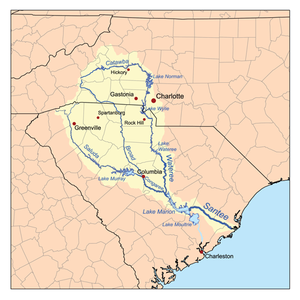
Santee River
The Santee River is a river in South Carolina in the United States, long. The Santee and its tributaries provide the principal drainage and navigation for the central coastal plain of South Carolina, emptying into the Atlantic Ocean approximately from its farthest headwater on the Catawba River...
in central South Carolina
South Carolina
South Carolina is a state in the Deep South of the United States that borders Georgia to the south, North Carolina to the north, and the Atlantic Ocean to the east. Originally part of the Province of Carolina, the Province of South Carolina was one of the 13 colonies that declared independence...
in the United States
United States
The United States of America is a federal constitutional republic comprising fifty states and a federal district...
, which flows to the Atlantic Ocean
Atlantic Ocean
The Atlantic Ocean is the second-largest of the world's oceanic divisions. With a total area of about , it covers approximately 20% of the Earth's surface and about 26% of its water surface area...
. Its name recalls the now-extinct Wateree
Wateree
The Wateree were one of the first groups of Native Americans in the interior of the East Coast to encounter Europeans. They were recorded in 1567, by Spanish captain Juan Pardo's scribe Bandera for his expeditions through the interior of the Carolinas. They were named the Guatari in Bandera's...
Native Americans
Native Americans in the United States
Native Americans in the United States are the indigenous peoples in North America within the boundaries of the present-day continental United States, parts of Alaska, and the island state of Hawaii. They are composed of numerous, distinct tribes, states, and ethnic groups, many of which survive as...
, who lived in the area until displaced by European settlers.
Course
The Wateree River is a continuation of the Catawba RiverCatawba River
The Catawba River is a tributary of the Wateree River in the U.S. states of North Carolina and South Carolina. The river is approximately 220 miles long...
, which flows from the Blue Ridge Mountains
Blue Ridge Mountains
The Blue Ridge Mountains are a physiographic province of the larger Appalachian Mountains range. This province consists of northern and southern physiographic regions, which divide near the Roanoke River gap. The mountain range is located in the eastern United States, starting at its southern-most...
in North Carolina
North Carolina
North Carolina is a state located in the southeastern United States. The state borders South Carolina and Georgia to the south, Tennessee to the west and Virginia to the north. North Carolina contains 100 counties. Its capital is Raleigh, and its largest city is Charlotte...
; the Catawba and Wateree are the same river with different names assigned to sections of it. The name change occurs at Lake Wateree
Lake Wateree
Lake Wateree is a reservoir in Kershaw, Fairfield, and Lancaster counties, South Carolina, in the United States. It is one of South Carolina's oldest man-made lakes. It has of shoreline and includes Lake Wateree State Recreation Area, a bird refuge, and Shaw Air Force Base Recreation center...
, which is formed by a hydroelectric
Hydroelectricity
Hydroelectricity is the term referring to electricity generated by hydropower; the production of electrical power through the use of the gravitational force of falling or flowing water. It is the most widely used form of renewable energy...
dam
Dam
A dam is a barrier that impounds water or underground streams. Dams generally serve the primary purpose of retaining water, while other structures such as floodgates or levees are used to manage or prevent water flow into specific land regions. Hydropower and pumped-storage hydroelectricity are...
in Kershaw County, South Carolina, about the point where Wateree Creek empties into it. The Wateree flows generally southward through Kershaw County and along the common boundary of Richland
Richland County, South Carolina
Richland County is a county located in the U.S. state of South Carolina. The 2000 U.S. census recorded its population to be 320,677. In 2010, the U.S. Census Bureau recorded that its population had reached 384,504. It is the second most populous county in South Carolina, behind only Greenville...
and Sumter counties, past the town of Camden
Camden, South Carolina
Camden is the fourth oldest city in the U.S. state of South Carolina and is also the county seat of Kershaw County, South Carolina, United States. The population was an estimated 7,103 in 2009...
. It joins the Congaree River
Congaree River
The Congaree River is a short but wide river in South Carolina in the United States; It flows for only 47 miles . The river serves an important role as the final outlet channel for the entire Lower Saluda and Lower Broad watersheds, before merging with the Wateree River just north of Lake Marion to...
to form the Santee River about 35 mi (55 km) southeast of Columbia
Columbia, South Carolina
Columbia is the state capital and largest city in the U.S. state of South Carolina. The population was 129,272 according to the 2010 census. Columbia is the county seat of Richland County, but a portion of the city extends into neighboring Lexington County. The city is the center of a metropolitan...
.
Crossings
The following is a list of crossings along the short length of the Wateree- US 1/US 601 in CamdenCamden, South CarolinaCamden is the fourth oldest city in the U.S. state of South Carolina and is also the county seat of Kershaw County, South Carolina, United States. The population was an estimated 7,103 in 2009...
& LugoffLugoff, South CarolinaLugoff is a small census-designated place in Kershaw County, South Carolina, United States. The population was 6,278 at the 2000 census. The population was nearly 85% rural in 2000... - Railroad bridge in Camden
- Interstate 20Interstate 20Interstate 20 is a major east–west Interstate Highway in the Southern United States. I‑20 runs 1,535 miles from near Kent, Texas, at Interstate 10 to Florence, South Carolina, at Interstate 95...
in Camden - Garner's Ferry Road US 378 near StateburgStateburg, South CarolinaStateburg is a census-designated place in the High Hills of Santee in Sumter County, South Carolina, United States. The population was 1,264 at the 2000 census. It is included in the Sumter, South Carolina Metropolitan Statistical Area...
- Two railroad bridges near the confluence with the Congaree RiverCongaree RiverThe Congaree River is a short but wide river in South Carolina in the United States; It flows for only 47 miles . The river serves an important role as the final outlet channel for the entire Lower Saluda and Lower Broad watersheds, before merging with the Wateree River just north of Lake Marion to...
near EastoverEastover, South CarolinaEastover is a town in Richland County, South Carolina, United States. The population was 830 at the 2000 census. It is part of the Columbia, South Carolina Metropolitan Statistical Area.-Geography:Eastover is located at ....
Sources
- Columbia Gazetteer of North America entry
- DeLormeDeLormeDeLorme is a major vendor of business-to-business and consumer mapping and GPS products and technologies. It is based in Yarmouth, Maine, United States....
(1998). South Carolina Atlas & Gazetteer. Yarmouth, Maine: DeLorme. ISBN 0-89933-237-4., retrieved 6 February 2006