

List of Sites of Special Scientific Interest in South Yorkshire
Encyclopedia
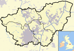
South Yorkshire
South Yorkshire is a metropolitan county in the Yorkshire and the Humber region of England. It has a population of 1.29 million. It consists of four metropolitan boroughs: Barnsley, Doncaster, Rotherham, and City of Sheffield...
, United Kingdom
United Kingdom
The United Kingdom of Great Britain and Northern IrelandIn the United Kingdom and Dependencies, other languages have been officially recognised as legitimate autochthonous languages under the European Charter for Regional or Minority Languages...
. , There are 35 sites designated within this Area of Search
Area of Search
Areas of Search are geographical areas used in the selection of Sites of Special Scientific Interest. In England these are largely based on the 1974–1996 administrative counties...
, of which 18 have been designated due to their biological interest, 13 due to its geological interest, and 4 for both biological and geological interest. In England the body responsible for designating SSSIs is Natural England
Natural England
Natural England is the non-departmental public body of the UK government responsible for ensuring that England's natural environment, including its land, flora and fauna, freshwater and marine environments, geology and soils, are protected and improved...
, which chooses a site because of its fauna
Fauna
Fauna or faunæ is all of the animal life of any particular region or time. The corresponding term for plants is flora.Zoologists and paleontologists use fauna to refer to a typical collection of animals found in a specific time or place, e.g. the "Sonoran Desert fauna" or the "Burgess shale fauna"...
, flora
Plant
Plants are living organisms belonging to the kingdom Plantae. Precise definitions of the kingdom vary, but as the term is used here, plants include familiar organisms such as trees, flowers, herbs, bushes, grasses, vines, ferns, mosses, and green algae. The group is also called green plants or...
, geological
Geology
Geology is the science comprising the study of solid Earth, the rocks of which it is composed, and the processes by which it evolves. Geology gives insight into the history of the Earth, as it provides the primary evidence for plate tectonics, the evolutionary history of life, and past climates...
or physiographical features. Natural England took over the role of designating and managing SSSIs from English Nature
English Nature
English Nature was the United Kingdom government agency that promoted the conservation of wildlife, geology and wild places throughout England between 1990 and 2006...
in October 2006 when it was formed from the amalgamation of English Nature, parts of the Countryside Agency
Countryside Agency
The Countryside Agency in England was a statutory body set up in 1999 with the task of improving the quality of the rural environment and the lives of those living in it. The Agency was formed by merging the Countryside Commission and the Rural Development Commission...
and the Rural Development Service
Rural Development Service
The Rural Development Service was formerly part of the UK Government's Department for Environment, Food and Rural Affairs . It ceased to exist on 1 October 2006 following the creation of Natural England.- History :...
. Natural England, like its predecessor, uses the 1974-1996 county system
Metropolitan and non-metropolitan counties of England
Metropolitan and non-metropolitan counties are one of the four levels of subdivisions of England used for the purposes of local government outside Greater London. As originally constituted, the metropolitan and non-metropolitan counties each consisted of multiple districts, had a county council and...
and as such the same approach is followed here, rather than, for example, merging all Yorkshire
Yorkshire
Yorkshire is a historic county of northern England and the largest in the United Kingdom. Because of its great size in comparison to other English counties, functions have been increasingly undertaken over time by its subdivisions, which have also been subject to periodic reform...
sites into a single list. Natural England produces citation sheets for each SSSI and are the main source of information for this list.
South Yorkshire's geography can be split into different types. The very west of South Yorkshire is part of Dark Peak
Dark Peak
The Dark Peak is the higher, wilder northern part of the Peak District in England.It gets its name because , the underlying limestone is covered by a cap of Millstone Grit which means that in winter the soil is almost always saturated with water...
which is part of the Peak District National Park and lies to the west of Sheffield
Sheffield
Sheffield is a city and metropolitan borough of South Yorkshire, England. Its name derives from the River Sheaf, which runs through the city. Historically a part of the West Riding of Yorkshire, and with some of its southern suburbs annexed from Derbyshire, the city has grown from its largely...
. This extensive moorland is one of the largest semi-natural areas in England and has broad plateau
Plateau
In geology and earth science, a plateau , also called a high plain or tableland, is an area of highland, usually consisting of relatively flat terrain. A highly eroded plateau is called a dissected plateau...
s with rocky outcrops interspersed with valleys. Moving east the land elevation drops with a transition from the peak district to coal fields. Much of this area of transition has seen urban development with Sheffield being a good example.
The central region, to the north of Sheffield
Sheffield
Sheffield is a city and metropolitan borough of South Yorkshire, England. Its name derives from the River Sheaf, which runs through the city. Historically a part of the West Riding of Yorkshire, and with some of its southern suburbs annexed from Derbyshire, the city has grown from its largely...
is largely dependent on the presence of coal measures in the areas geology. This is reflected by ancient woodlands, valley wetlands and large arable fields where there is no urban development. To the east of the coal measures is a strip of Magnesian Limestone
Dolostone
Dolostone or dolomite rock is a sedimentary carbonate rock that contains a high percentage of the mineral dolomite. In old U.S.G.S. publications it was referred to as magnesian limestone. Most dolostone formed as a magnesium replacement of limestone or lime mud prior to lithification. It is...
which runs north to south between Sheffield and Doncaster
Doncaster
Doncaster is a town in South Yorkshire, England, and the principal settlement of the Metropolitan Borough of Doncaster. The town is about from Sheffield and is popularly referred to as "Donny"...
. This open landscape is characterised by ancient woodlands and limestone grasslands and often has historic limestone monuments. However the light and dry soils are ideal for cultivation which means little of the original habitat remains. In the very east of South Yorkshire the Humberhead Levels
Humberhead Levels
The Humberhead Levels cover a large expanse of very flat, low lying land towards the eastern end of the Humber estuary in northern England. The Levels occupies the area of the former Glacial Lake Humber...
dominate, with the area being relatively flat and dominated by the areas river systems. The area is predominately covered with small fields or areas of peatland.