
List of Sites of Special Scientific Interest in Avon
Encyclopedia
Avon (county)
Avon was, from 1974 to 1996, a non-metropolitan and ceremonial county in the west of England.The county was named after the River Avon, which runs through the area. It was formed from parts of the historic counties of Gloucestershire and Somerset, together with the City of Bristol...
, England, United Kingdom. In England the body responsible for designating SSSIs is Natural England
Natural England
Natural England is the non-departmental public body of the UK government responsible for ensuring that England's natural environment, including its land, flora and fauna, freshwater and marine environments, geology and soils, are protected and improved...
, which chooses a site because of its fauna
Fauna
Fauna or faunæ is all of the animal life of any particular region or time. The corresponding term for plants is flora.Zoologists and paleontologists use fauna to refer to a typical collection of animals found in a specific time or place, e.g. the "Sonoran Desert fauna" or the "Burgess shale fauna"...
, flora
Plant
Plants are living organisms belonging to the kingdom Plantae. Precise definitions of the kingdom vary, but as the term is used here, plants include familiar organisms such as trees, flowers, herbs, bushes, grasses, vines, ferns, mosses, and green algae. The group is also called green plants or...
, geological
Geology
Geology is the science comprising the study of solid Earth, the rocks of which it is composed, and the processes by which it evolves. Geology gives insight into the history of the Earth, as it provides the primary evidence for plate tectonics, the evolutionary history of life, and past climates...
or physiographical features. Although the county of Avon no longer exists, Natural England still uses its former borders to mark one of its Areas of Search
Area of Search
Areas of Search are geographical areas used in the selection of Sites of Special Scientific Interest. In England these are largely based on the 1974–1996 administrative counties...
. As of 2006, there are 86 sites designated in this Area of Search
Area of Search
Areas of Search are geographical areas used in the selection of Sites of Special Scientific Interest. In England these are largely based on the 1974–1996 administrative counties...
, of which 39 have been designated due to their biological interest, 39 due to their geological interest, and 8 for both.
English Nature
English Nature was the United Kingdom government agency that promoted the conservation of wildlife, geology and wild places throughout England between 1990 and 2006...
in October 2006 when it was formed from the amalgamation of English Nature, parts of the Countryside Agency
Countryside Agency
The Countryside Agency in England was a statutory body set up in 1999 with the task of improving the quality of the rural environment and the lives of those living in it. The Agency was formed by merging the Countryside Commission and the Rural Development Commission...
and the Rural Development Service
Rural Development Service
The Rural Development Service was formerly part of the UK Government's Department for Environment, Food and Rural Affairs . It ceased to exist on 1 October 2006 following the creation of Natural England.- History :...
. Natural England, like its predecessor, uses the 1974–1996 county system
Metropolitan and non-metropolitan counties of England
Metropolitan and non-metropolitan counties are one of the four levels of subdivisions of England used for the purposes of local government outside Greater London. As originally constituted, the metropolitan and non-metropolitan counties each consisted of multiple districts, had a county council and...
and as such the same approach is followed here, rather than splitting these sites between the Somerset and Gloucestershire lists. The data in the table is taken from English Nature in the form of citation sheets for each SSSI.
For other counties, see List of SSSIs by Area of Search.
A–B
| Site name | Reason for Designation | Area | Grid reference | Year in which notified | Map | ||
|---|---|---|---|---|---|---|---|
| Biological Interest | Geological Interest | Hectares | Acres | ||||
| Ashton Court Ashton Court Ashton Court is a mansion house and estate to the west of Bristol in England. Although the estate lies mainly in North Somerset, it is owned by the City of Bristol. The estate has been a venue for a variety of leisure activities, including the now-defunct Ashton Court festival, Bristol... |
210.3 | 519.7 | 1998 | http://www.natureonthemap.naturalengland.org.uk/map.aspx?map=sssi&feature=2000331,sssi,HYPERLINK,LABEL | |||
| Aust Cliff Aust Cliff Aust Cliff is a 5.3 hectare geological Site of Special Scientific Interest adjacent to the Severn Estuary, near the village of Aust, South Gloucestershire, notified in 1954. The Severn Bridge crosses the cliff.... |
5.3 | 13.1 | 1954 | http://www.natureonthemap.naturalengland.org.uk/map.aspx?map=sssi&feature=1000724,sssi,HYPERLINK,LABEL | |||
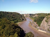
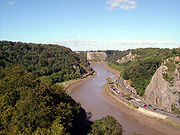
| Avon Gorge Avon Gorge The Avon Gorge is a 1.5-mile long gorge on the River Avon in Bristol, England. The gorge runs south to north through a limestone ridge west of Bristol city centre, and about 3 miles from the mouth of the river at Avonmouth. The gorge forms the boundary between the unitary authorities of... |
155.4 | 384.0 | 1952 | http://www.natureonthemap.naturalengland.org.uk/map.aspx?map=sssi&feature=1003073,sssi,HYPERLINK,LABEL | |||
| Banwell Caves Banwell Caves Banwell Caves are a 1.7-hectare geological and biological Site of Special Scientific Interest near the village of Banwell, North Somerset, England notified in 1963.... |
1.7 | 4.2 | 1963 | http://www.natureonthemap.naturalengland.org.uk/map.aspx?map=sssi&feature=1000754,sssi,HYPERLINK,LABEL | |||
| Banwell Ochre Caves Banwell Ochre Caves Banwell Ochre Caves are a 12.46-hectare geological Site of Special Scientific Interest near the village of Banwell, North Somerset, notified in 1983.... |
12.5 | 30.8 | 1983 | http://www.natureonthemap.naturalengland.org.uk/map.aspx?map=sssi&feature=1004187,sssi,HYPERLINK,LABEL | |||
| Barnhill Quarry Barnhill Quarry Barnhill Quarry is a 3.1 hectare geological Site of Special Scientific Interest near Chipping Sodbury, South Gloucestershire, notified in 1966.-Source:*... |
3.1 | 7.7 | 1966 | http://www.natureonthemap.naturalengland.org.uk/map.aspx?map=sssi&feature=1000779,sssi,HYPERLINK,LABEL |
|-
| Barns Batch Spinney
Barns Batch Spinney
Barns Batch Spinney is a 0.06-hectare geological Site of Special Scientific Interest near the village of Dundry, North Somerset, notified in 1987....
| align="center" |
| align="center" |
| align="right" |0.1
| align="right" |0.2
| align="center" |
| align="center" |1987
| align="center" |http://www.natureonthemap.naturalengland.org.uk/map.aspx?map=sssi&feature=1003797,sssi,HYPERLINK,LABEL
|-
| Bickley Wood
Bickley Wood
Bickley Wood is a 9.5 hectare geological Site of Special Scientific Interest just north of River Avon, near the village of Longwell Green, Bristol, notified in 1988.-Source:*...
| align="center" |
| align="center" |
| align="right" |9.5
| align="right" |23.5
| align="center" |
| align="center" |1988
| align="center" |http://www.natureonthemap.naturalengland.org.uk/map.aspx?map=sssi&feature=1000535,sssi,HYPERLINK,LABEL
|-
| Biddle Street, Yatton
Biddle Street, Yatton
Biddle Street, Yatton is a 44.8 hectare biological Site of Special Scientific Interest near the village of Yatton in North Somerset, notified in 1994....
| align="center" |
| align="center" |
| align="right" |44.8
| align="right" |110.7
| align="center" |
| align="center" |1994
| align="center" |http://www.natureonthemap.naturalengland.org.uk/map.aspx?map=sssi&feature=1006788,sssi,HYPERLINK,LABEL
|-
| Bishop's Hill Wood
Bishop's Hill Wood
Bishop's Hill Wood is a 30.6 hectare biological Site of Special Scientific Interest , which lies just to the east of the village of Wickwar, South Gloucestershire, notified in 1984....
| align="center" |
| align="center" |
| align="right" |30.6
| align="right" |75.6
| align="center" |
| align="center" |1984
| align="center" |http://www.natureonthemap.naturalengland.org.uk/map.aspx?map=sssi&feature=1003718,sssi,HYPERLINK,LABEL
|-
| Blagdon Lake
Blagdon Lake
Blagdon Lake lies in the Chew Valley at the northern edge of the Mendip Hills, approximately 10 mi south of Bristol, England. The lake was created by Bristol Water , when it dammed the River Yeo, starting construction in 1891 and completing this in 1899...
| align="center" |
| align="center" |
| align="right" |212.7
| align="right" |525.6
| align="center" |
| align="center" |1971
| align="center" |http://www.natureonthemap.naturalengland.org.uk/map.aspx?map=sssi&feature=1000808,sssi,HYPERLINK,LABEL
|-
| Bleadon Hill
Bleadon Hill
Bleadon Hill is a 13.52 hectare geological Site of Special Scientific Interest just north of the village of Bleadon, North Somerset, notified in 1999....
| align="center" |
| align="center" |
| align="right" |13.5
| align="right" |33.4
| align="center" |
| align="center" |1999
| align="center" |http://www.natureonthemap.naturalengland.org.uk/map.aspx?map=sssi&feature=2000359,sssi,HYPERLINK,LABEL
|-
| Bodkin Hazel Wood
Bodkin Hazel Wood
Bodkin Hazel Wood is a 10.62 hectare biological Site of Special Scientific Interest , just south of the village of Hawkesbury Upton in South Gloucestershire, notified in 1974.-Biological interest:The site has a diverse ground flora...
| align="center" |
| align="center" |
| align="right" |10.6
| align="right" |26.2
| align="center" |
| align="center" |1974
| align="center" |http://www.natureonthemap.naturalengland.org.uk/map.aspx?map=sssi&feature=1000820,sssi,HYPERLINK,LABEL
|-
| Bourne
Bourne SSSI, Avon
Bourne SSSI, Avon is a 8.47 hectare geological Site of Special Scientific Interest near the village of Burrington, North Somerset, notified in 1992....
| align="center" |
| align="center" |
| align="right" |8.5
| align="right" |20.9
| align="center" |
| align="center" |1992
| align="center" |http://www.natureonthemap.naturalengland.org.uk/map.aspx?map=sssi&feature=1000563,sssi,HYPERLINK,LABEL
|-
| Bowlditch Quarry
Bowlditch Quarry
Bowlditch Quarry is a 0.25 hectare geological Site of Special Scientific Interest near the village of Clandown, Bath and North East Somerset, notified in 1952....
| align="center" |
| align="center" |
| align="right" |0.3
| align="right" |0.6
| align="center" |
| align="center" |1952
| align="center" |http://www.natureonthemap.naturalengland.org.uk/map.aspx?map=sssi&feature=1000841,sssi,HYPERLINK,LABEL
|-
| Brinkmarsh Quarry
Brinkmarsh Quarry
Brinkmarsh Quarry is a 0.5 hectare geological Site of Special Scientific Interest near the town of Thornbury, South Gloucestershire, notified in 1974.-Source:*...
| align="center" |
| align="center" |
| align="right" |0.5
| align="right" |1.2
| align="center" |
| align="center" |1974
| align="center" |http://www.natureonthemap.naturalengland.org.uk/map.aspx?map=sssi&feature=1000872,sssi,HYPERLINK,LABEL
|-
| Brockley Hall Stables
Brockley Hall Stables
Brockley Hall Stables is a 0.065 hectare biological Site of Special Scientific Interest near the village of Brockley, North Somerset, notified in 1987.-Biological Interest:...
| align="center" |
| align="center" |
| align="right" |0.1
| align="right" |0.2
| align="center" |
| align="center" |1987
| align="center" |http://www.natureonthemap.naturalengland.org.uk/map.aspx?map=sssi&feature=1001436,sssi,HYPERLINK,LABEL
|-
| Brown's Folly
Brown's Folly
Brown's Folly is a 39.9 hectare biological and geological Site of Special Scientific Interest near the village of Bathford in Bath and North East Somerset, notified in 1974. Also known as Farleigh Down Stone Quarry, it is operated as a nature reserve by the Avon Wildlife Trust .Brown's Folly is...
| align="center" |
| align="center" |
| align="right" |39.9
| align="right" |98.5
| align="center" |
| align="center" |1974
| align="center" |http://www.natureonthemap.naturalengland.org.uk/map.aspx?map=sssi&feature=1002510,sssi,HYPERLINK,LABEL
|-
| Buckover Road Cutting
Buckover Road Cutting
Buckover Road Cutting is a 1.7 hectare geological Site of Special Scientific Interest near the town of Thornbury, South Gloucestershire, notified in 1967.The site shows an unconformity between Silurian rocks and quartz conglomerate of the Devonian period....
| align="center" |
| align="center" |
| align="right" |1.7
| align="right" |4.1
| align="center" |
| align="center" |1967
| align="center" |http://www.natureonthemap.naturalengland.org.uk/map.aspx?map=sssi&feature=1002532,sssi,HYPERLINK,LABEL
|-
| Burledge Sidelands and Meadows
Burledge Hill
Burledge Hill is on the southern edge of the village of Bishop Sutton, Somerset, England. It is the site of a Site of Special Scientific Interest and an univallate Iron Age hillfort.-Site of Special Scientific Interest:...
| align="center" |
| align="center" |
| align="right" |48.7
| align="right" |120.3
| align="center" |
| align="center" |2005
| align="center" |http://www.natureonthemap.naturalengland.org.uk/map.aspx?map=sssi&feature=2000519,sssi,HYPERLINK,LABEL
|-
| Burrington Combe
Burrington Combe
Burrington Combe is a carboniferous limestone gorge near the village of Burrington, on the north side of the Mendip Hills Area of Outstanding Natural Beauty, in North Somerset, England....
| align="center" |
| align="center" |
| align="right" |139.1
| align="right" |343.8
| align="center" |
| align="center" |1952
| align="center" |http://www.natureonthemap.naturalengland.org.uk/map.aspx?map=sssi&feature=1002537,sssi,HYPERLINK,LABEL
|}
C–G
| Site name | Reason for Designation | Area | Grid reference | Year in which notified | Map | ||
|---|---|---|---|---|---|---|---|
| Biological Interest | Geological Interest | Hectares | Acres | ||||
| Cattybrook Brickpit Cattybrook Brickpit Cattybrook Brickpit is a 2.2 hectare geological Site of Special Scientific Interest near the village of Almondsbury, South Gloucestershire, notified in 1989.-Source:*... |
2.2 | 5.5 | 1989 | http://www.natureonthemap.naturalengland.org.uk/map.aspx?map=sssi&feature=1001452,sssi,HYPERLINK,LABEL | |||
| Chew Valley Lake Chew Valley Lake Chew Valley Lake is a large reservoir in the Chew Valley, Somerset, England, and the fifth-largest artificial lake in the United Kingdom , with an area of 1,200 acres... |
565.2 | 1,396.6 | 1971 | http://www.natureonthemap.naturalengland.org.uk/map.aspx?map=sssi&feature=1002553,sssi,HYPERLINK,LABEL | |||
| Cleaves Wood Cleaves Wood Cleaves Wood is a 40.38 hectare biological Site of Special Scientific Interest near the village of Wellow in Bath and North East Somerset, notified in 1988.Cleaves Wood is an ancient, semi-natural deciduous woodland on Oolitic Limestone... |
40.4 | 99.8 | 1988 | http://www.natureonthemap.naturalengland.org.uk/map.aspx?map=sssi&feature=1000159,sssi,HYPERLINK,LABEL | |||
| Cleeve Wood, Hanham Cleeve Wood, Hanham Cleeve Wood, Hanham is a is an 8.9 hectare biological Site of Special Scientific Interest in South Gloucestershire, notified in 1966.Cleeve Wood is situated on the steep south facing slopes of the River Avon valleynear to the City of Bristol.... |
8.9 | 21.9 | 1966 | http://www.natureonthemap.naturalengland.org.uk/map.aspx?map=sssi&feature=1002574,sssi,HYPERLINK,LABEL | |||
| Clevedon Shore Clevedon Shore Clevedon Shore is a 0.38 hectare geological Site of Special Scientific Interest adjacent to the Severn Estuary at Clevedon, North Somerset, notified in 1991.... |
0.4 | 0.9 | 1991 | http://www.natureonthemap.naturalengland.org.uk/map.aspx?map=sssi&feature=1005605,sssi,HYPERLINK,LABEL | |||
| Combe Down and Bathampton Down Mines Combe Down and Bathampton Down Mines Combe Down and Bathampton Down Mines is a 6.22 hectare Site of Special Scientific Interest in Bath and North East Somerset, notified in 1991 because of the Greater and Lesser Horseshoe bat population.... |
6.2 | 15.4 | 1991 | http://www.natureonthemap.naturalengland.org.uk/map.aspx?map=sssi&feature=1005602,sssi,HYPERLINK,LABEL | |||
| Compton Martin Ochre Mine Compton Martin Ochre Mine Compton Martin Ochre Mine is a 0.85 hectare geological and biological Site of Special Scientific Interest located on the north side of the Mendip Hills, immediately south west of Compton Martin village, Somerset, notified in 1988.-Geological Interest:... |
0.9 | 2.1 | 1988 | http://www.natureonthemap.naturalengland.org.uk/map.aspx?map=sssi&feature=1004205,sssi,HYPERLINK,LABEL | |||
| Congrove Field and The Tumps Congrove Field and The Tumps Congrove Field and The Tumps is a is an 12.5 hectare biological Site of Special Scientific Interest on Lansdown Hill, north of Bath in Bath and North East Somerset, notified in 1991.... |
12.5 | 30.8 | 1991 | http://www.natureonthemap.naturalengland.org.uk/map.aspx?map=sssi&feature=1006283,sssi,HYPERLINK,LABEL | |||
| Court Hill Court Hill Court Hill is a 10.45 hectare geological Site of Special Scientific Interest near the town of Clevedon, North Somerset, England; notified in 1997.... |
10.5 | 25.8 | 1997 | http://www.natureonthemap.naturalengland.org.uk/map.aspx?map=sssi&feature=2000219,sssi,HYPERLINK,LABEL | |||
| Cullimore's Quarry Cullimore's Quarry Cullimore's Quarry is a 0.9 hectare geological Site of Special Scientific Interest near the village of Charfield, South Gloucestershire, notified in 1974.-Source:*... |
0.9 | 2.2 | 1974 | http://www.natureonthemap.naturalengland.org.uk/map.aspx?map=sssi&feature=1002615,sssi,HYPERLINK,LABEL | |||
| Damery Road Section Damery Road Section Damery Road Section is a 0.5 hectare geological Site of Special Scientific Interest north of Tortworth, South Gloucestershire, notified in 1974.-Source:*... |
0.5 | 1.0 | 1974 | http://www.natureonthemap.naturalengland.org.uk/map.aspx?map=sssi&feature=1002626,sssi,HYPERLINK,LABEL | |||
| Dolebury Warren Dolebury Warren Dolebury Warren is a 90.6 hectare biological Site of Special Scientific Interest near the village of Churchill in North Somerset, notified in 1952... |
90.6 | 223.3 | 1952 | http://www.natureonthemap.naturalengland.org.uk/map.aspx?map=sssi&feature=1002660,sssi,HYPERLINK,LABEL | |||
| Dundry Main Road South Quarry Dundry Main Road South Quarry Dundry Main Road South Quarry is a 0.7 hectare geological Site of Special Scientific Interest near the village of East Dundry, North Somerset, notified in 1974.... |
0.7 | 1.8 | 1974 | http://www.natureonthemap.naturalengland.org.uk/map.aspx?map=sssi&feature=1002681,sssi,HYPERLINK,LABEL | |||
| Ellenborough Park West | 1.8 | 4.4 | 1989 | http://www.natureonthemap.naturalengland.org.uk/map.aspx?map=sssi&feature=1005488,sssi,HYPERLINK,LABEL | |||
| Folly Farm | 3.1 | 7.7 | 1987 | http://www.natureonthemap.naturalengland.org.uk/map.aspx?map=sssi&feature=1003609,sssi,HYPERLINK,LABEL | |||
| Goblin Combe Goblin Combe Goblin Combe is a valley in North Somerset which stretches from Redhill, near Bristol International Airport on the A38 through to Cleeve on the A370. The combe is located at , and is a biological Site of Special Scientific Interest originally notified in 1999, with being managed as a nature... |
51.9 | 128.2 | 1999 | http://www.natureonthemap.naturalengland.org.uk/map.aspx?map=sssi&feature=2000328,sssi,HYPERLINK,LABEL | |||
| Gordano Valley Gordano Valley Gordano is an area of North Somerset, in England. It has been designated as a National Nature Reserve.The name Gordano comes from Old English and is descriptive of the triangular shape of the whole valley from Clevedon to Portishead, being the ablative singular of the Latinised form of Gorden... |
161.7 | 399.5 | 1971 | http://www.natureonthemap.naturalengland.org.uk/map.aspx?map=sssi&feature=1002698,sssi,HYPERLINK,LABEL | |||
H–M
| Site name | Reason for Designation | Area | Grid reference | Year in which notified | Map | ||
|---|---|---|---|---|---|---|---|
| Biological Interest | Geological Interest | Hectares | Acres | ||||
| Ham Green Ham Green SSSI Ham Green SSSI is a 1.1 hectare geological Site of Special Scientific Interest near the village of Ham Green, North Somerset, notified in 1990.This is a Geological Conservation Review site.... |
1.1 | 2.7 | 1990 | http://www.natureonthemap.naturalengland.org.uk/map.aspx?map=sssi&feature=1001500,sssi,HYPERLINK,LABEL | |||
| Hampton Rocks Cutting Hampton Rocks Cutting Hampton Rocks Cutting is a 1.3 hectare geological Site of Special Scientific Interest near the village of Bathampton, Somerset, notified in 1990.... |
1.3 | 3.2 | 1990 | http://www.natureonthemap.naturalengland.org.uk/map.aspx?map=sssi&feature=1001514,sssi,HYPERLINK,LABEL | |||
| Harptree Combe Harptree Combe Harptree Combe is a Site of Special Scientific Interest near East Harptree notified in 1954. "Combe" or "coombe" is a West Country word meaning a steep-sided valley. It is also the site of a 19th century aqueduct and is overlooked by the site of a castle dating from around 1100.In August 2009 ... |
13.1 | 32.3 | 1954 | http://www.natureonthemap.naturalengland.org.uk/map.aspx?map=sssi&feature=1002713,sssi,HYPERLINK,LABEL | |||
| Hartcliff Rocks Quarry Hartcliff Rocks Quarry Hartcliff Rocks Quarry is a 1.6 hectare Site of Special Scientific Interest near Felton, Somerset notified in 1991.According to the citation, the site "provides exposures of Triassic Dolomitic Conglomerate unconformably overlying Carboniferous Limestone."-External links:*... |
1.6 | 3.9 | 1991 | http://www.natureonthemap.naturalengland.org.uk/map.aspx?map=sssi&feature=1005947,sssi,HYPERLINK,LABEL | |||
| Hawkesbury Meadow Hawkesbury Meadow Hawkesbury Meadow is a 3.3 hectare biological Site of Special Scientific Interest in South Gloucestershire, notified in 1987.-Source:*... |
3.3 | 8.2 | 1987 | http://www.natureonthemap.naturalengland.org.uk/map.aspx?map=sssi&feature=1000072,sssi,HYPERLINK,LABEL | |||
| Hawkesbury Quarry Hawkesbury Quarry Hawkesbury Quarry is a 0.25 hectare geological Site of Special Scientific Interest near the village of Hawkesbury Upton, South Gloucestershire, notified in 1967.... |
0.3 | 0.6 | 1967 | http://www.natureonthemap.naturalengland.org.uk/map.aspx?map=sssi&feature=1002733,sssi,HYPERLINK,LABEL | |||
| Hinton Charterhouse Field Hinton Charterhouse Field Hinton Charterhouse Field is a 0.32 hectare biological Site of Special Scientific Interest near the village of Hinton Charterhouse in Bath and North East Somerset, notified in 1991.... |
0.3 | 0.8 | 1991 | http://www.natureonthemap.naturalengland.org.uk/map.aspx?map=sssi&feature=1005938,sssi,HYPERLINK,LABEL | |||
| Hinton Charterhouse Pit Hinton Charterhouse Pit Hinton Charterhouse Pit is a 0.4 hectare geological Site of Special Scientific Interest near the village of Hinton Charterhouse, Bath and North East Somerset, notified in 1971.... |
0.4 | 1.0 | 1971 | http://www.natureonthemap.naturalengland.org.uk/map.aspx?map=sssi&feature=1002763,sssi,HYPERLINK,LABEL | |||
| Hinton Hill, Wellow Hinton Hill, Wellow Hinton Hill, Wellow is a 0.25 hectare geological Site of Special Scientific Interest near the village of Wellow in Somerset, notified in 1996.... |
0.3 | 0.6 | 1996 | http://www.natureonthemap.naturalengland.org.uk/map.aspx?map=sssi&feature=2000167,sssi,HYPERLINK,LABEL | |||
| Holly Lane Holly Lane SSSI Holly Lane SSSI is a 0.5 hectare geological Site of Special Scientific Interest near the village of Walton St. Mary, North Somerset, notified in 1990.... |
0.5 | 1.2 | 1990 | http://www.natureonthemap.naturalengland.org.uk/map.aspx?map=sssi&feature=1001530,sssi,HYPERLINK,LABEL | |||
| Horseshoe Bend, Shirehampton Horseshoe Bend, Shirehampton Horseshoe Bend, Shirehampton is a 4.45 hectare biological Site of Special Scientific Interest in Bristol, England, on the north bank of a lower, tidal stretch of the River Avon, 3 kilometres downstream from the Avon Gorge, and just east of the village of Shirehampton... |
4.5 | 11.0 | 1999 | http://www.natureonthemap.naturalengland.org.uk/map.aspx?map=sssi&feature=2000327,sssi,HYPERLINK,LABEL | |||
| Huish Colliery Quarry Huish Colliery Quarry Huish Colliery Quarry is a 0.8 hectare geological Site of Special Scientific Interest near the town of Radstock, Bath and North East Somerset, notified in 1985.... |
0.8 | 2.1 | 1985 | http://www.natureonthemap.naturalengland.org.uk/map.aspx?map=sssi&feature=1003734,sssi,HYPERLINK,LABEL | |||
| Iford Manor Iford Manor Iford Manor in Wiltshire sits on the steep slopes of the Frome valley, which itself has been occupied since Roman times. The house is mediaeval in origin, the classical façade having been added in the 18th century when the hanging woodlands above the garden were planted.-History and... |
0.4 | 1.0 | 1996 | http://www.natureonthemap.naturalengland.org.uk/map.aspx?map=sssi&feature=2000138,sssi,HYPERLINK,LABEL | |||
| Kenn Church, Kenn Pier & Yew Tree Farm Kenn Church, Kenn Pier & Yew Tree Farm SSSI Kenn Church, Kenn Pier & Yew Tree Farm SSSI is a 15.37 hectare geological Site of Special Scientific Interest near the village of Kenn, Somerset, notified in 1997.... |
15.4 | 38.0 | 1997 | http://www.natureonthemap.naturalengland.org.uk/map.aspx?map=sssi&feature=2000223,sssi,HYPERLINK,LABEL | |||
| Kilmersdon Road Quarry Kilmersdon Road Quarry Kilmersdon Road Quarry is a 0.43 hectare geological Site of Special Scientific Interest near the town of Radstock, Bath and North East Somerset, notified in 1954.... |
0.4 | 1.1 | 1954 | http://www.natureonthemap.naturalengland.org.uk/map.aspx?map=sssi&feature=1002781,sssi,HYPERLINK,LABEL | |||
| King's Wood and Urchin Wood King's Wood and Urchin Wood SSSI King's Wood and Urchin Wood SSSI is a 128.1 hectare biological Site of Special Scientific Interest near the villages of Cleeve and Congresbury, North Somerset, notified in 1990.... |
128.1 | 316.5 | 1990 | http://www.natureonthemap.naturalengland.org.uk/map.aspx?map=sssi&feature=1005522,sssi,HYPERLINK,LABEL | |||
| Long Dole Wood and Meadows | 9.8 | 24.3 | 1997 | http://www.natureonthemap.naturalengland.org.uk/map.aspx?map=sssi&feature=1001549,sssi,HYPERLINK,LABEL | |||
| Lower Woods Lower Woods Lower Woods is a 280.1 hectare biological and geological Site of Special Scientific Interest near the village of Wickwar, South Gloucestershire, notified in 1966... |
280.1 | 692.2 | 1966 | http://www.natureonthemap.naturalengland.org.uk/map.aspx?map=sssi&feature=1002798,sssi,HYPERLINK,LABEL | |||
| Lulsgate Quarry Lulsgate Quarry Lulsgate Quarry is a 1.13 hectare geological Site of Special Scientific Interest near the village of Felton, North Somerset, notified in 1997.The site has an excellent exposure of an irregular unconformity surface lying between inclined Lower... |
1.1 | 2.8 | 1997 | http://www.natureonthemap.naturalengland.org.uk/map.aspx?map=sssi&feature=2000161,sssi,HYPERLINK,LABEL | |||
| Max Bog Max Bog Max Bog is a 10.6 hectare biological Site of Special Scientific Interest west of the village of Winscombe, North Somerset, notified in 1988.The site is owned by North Somerset Council and managed by the Avon Wildlife Trust for the range of wetland plants that it supports.-Ecology:Marsh Helleborine... |
10.6 | 26.2 | 1988 | http://www.natureonthemap.naturalengland.org.uk/map.aspx?map=sssi&feature=1003773,sssi,HYPERLINK,LABEL | |||
| Middle Hope Middle Hope Middle Hope is a 84.1 hectare biological and geological Site of Special Scientific Interest on Sand Point north of the town of Weston-super-Mare, North Somerset, notified in 1952.-Geology:... |
84.1 | 207.8 | 1952 | http://www.natureonthemap.naturalengland.org.uk/map.aspx?map=sssi&feature=1002814,sssi,HYPERLINK,LABEL | |||
| Midger Midger Midger is a 65.7 hectare biological Site of Special Scientific Interest straddling the border of Gloucestershire and South Gloucestershire, notified in 1966. It lies east of Hillesley, Gloucestershire and north of Hawkesbury Upton, South Gloucestershire.... |
65.7 | 162.3 | 1966 | http://www.natureonthemap.naturalengland.org.uk/map.aspx?map=sssi&feature=1002832,sssi,HYPERLINK,LABEL | |||
| Monkswood Valley Monkswood Valley Monkswood Valley is a 30.7 hectare biological Site of Special Scientific Interest near the village of Cold Ashton, South Gloucestershire, notified in 1990.-Source:*... |
30.7 | 75.9 | 1990 | http://www.natureonthemap.naturalengland.org.uk/map.aspx?map=sssi&feature=1005472,sssi,HYPERLINK,LABEL |
N–S
| Site name | Reason for Designation | Area | Grid reference | Year in which notified | Map | ||
|---|---|---|---|---|---|---|---|
| Biological Interest | Geological Interest | Hectares | Acres | ||||
| Newton St. Loe Newton Saint Loe SSSI Newton St Loe SSSI is a geological Site of Special Scientific Interest close to the River Avon, near the village of Newton St Loe in Bath and North East Somerset... |
2.3 | 5.6 | 1992 | http://www.natureonthemap.naturalengland.org.uk/map.aspx?map=sssi&feature=1002500,sssi,HYPERLINK,LABEL | |||
| Nightingale Valley Nightingale Valley Nightingale Valley is a 5.4 hectare geological Site of Special Scientific Interest near the town of Portishead, North Somerset, notified in 1989.... |
5.4 | 13.3 | 1989 | http://www.natureonthemap.naturalengland.org.uk/map.aspx?map=sssi&feature=1002518,sssi,HYPERLINK,LABEL | |||
| North Road Quarry, Bath North Road Quarry, Bath North Road Quarry, Bath is a 0.3 hectare geological Site of Special Scientific Interest close to Sham Castle in the city of Bath, Somerset, notified in 1990.... |
0.3 | 0.7 | 1990 | http://www.natureonthemap.naturalengland.org.uk/map.aspx?map=sssi&feature=1000511,sssi,HYPERLINK,LABEL | |||
| Plaster's Green Meadows Plaster's Green Meadows Plaster's Green Meadows is a 4.3 hectare biological Site of Special Scientific Interest near the village of Nempnett Thrubwell, Bath and North East Somerset, notified in 1989.... |
4.3 | 10.6 | 1989 | http://www.natureonthemap.naturalengland.org.uk/map.aspx?map=sssi&feature=1004121,sssi,HYPERLINK,LABEL | |||
| Portishead Pier to Black Nore Portishead Pier to Black Nore SSSI Portishead Pier to Black Nore SSSI is a 71.8 hectare geological Site of Special Scientific Interest near the town of Portishead in North Somerset, notified in 1952.... |
71.8 | 177.4 | 1952 | http://www.natureonthemap.naturalengland.org.uk/map.aspx?map=sssi&feature=1002867,sssi,HYPERLINK,LABEL | |||
| Purn Hill Purn Hill Purn Hill is a 6.1 hectare biological Site of Special Scientific Interest near the village of Bleadon, Somerset, notified in 1990. The site is a small promontory of Carboniferous Limestone projecting southward from the main Mendip ridge.... |
6.1 | 15.1 | 1990 | http://www.natureonthemap.naturalengland.org.uk/map.aspx?map=sssi&feature=1000697,sssi,HYPERLINK,LABEL | |||
| Puxton Moor Puxton Moor Puxton Moor is a 31.07 hectare biological Site of Special Scientific Interest on the North Somerset Levels, near Puxton, North Somerset, notified in 1994... |
31.1 | 76.8 | 1994 | http://www.natureonthemap.naturalengland.org.uk/map.aspx?map=sssi&feature=1006787,sssi,HYPERLINK,LABEL | |||
| Quarry Steps, Durdham Down Quarry Steps, Durdham Down Quarry Steps, Durdham Down is a 0.006 hectare geological Site of Special Scientific Interest near Durdham Down in Bristol, notified in 1990.It was in this area that the first Thecodontosaurus fossil was discovered in 1834.-Source:... |
<0.1 | <0.1 | 1990 | http://www.natureonthemap.naturalengland.org.uk/map.aspx?map=sssi&feature=1001484,sssi,HYPERLINK,LABEL | |||
| Severn Estuary Severn Estuary The Severn Estuary is the estuary of the River Severn, the longest river in Great Britain. Its high tidal range means it has been at the centre of discussions in the UK regarding renewable energy.-Geography:... |
15,950.0 | 39,410.0 | 1976 | http://www.natureonthemap.naturalengland.org.uk/map.aspx?map=sssi&feature=1002284,sssi,HYPERLINK,LABEL | |||
| Shiplate Slait Shiplate Slait Shiplate Slait is a 33.9 hectare biological Site of Special Scientific Interest near the village of Loxton, within the Mendip Hills Area of Outstanding Natural Beauty, North Somerset, notified in 1987.... |
33.9 | 83.8 | 1987 | http://www.natureonthemap.naturalengland.org.uk/map.aspx?map=sssi&feature=1002116,sssi,HYPERLINK,LABEL | |||
| Slickstones Quarry, Cromhall Slickstones Quarry, Cromhall Slickstones Quarry, Cromhall is a 2.7 hectare geological Site of Special Scientific Interest near the village of Cromhall, South Gloucestershire, notified in 1966.The site shows red Triassic rocks in fissures of older carboniferous limestone.... |
2.7 | 6.6 | 1966 | http://www.natureonthemap.naturalengland.org.uk/map.aspx?map=sssi&feature=1002898,sssi,HYPERLINK,LABEL | |||
| Spring Cove Cliffs Spring Cove Cliffs Spring Cove Cliffs is a 2.0 hectare geological Site of Special Scientific Interest near the town of Weston-super-Mare, North Somerset, notified in 1952.... |
2.0 | 4.9 | 1952 | http://www.natureonthemap.naturalengland.org.uk/map.aspx?map=sssi&feature=1002927,sssi,HYPERLINK,LABEL | |||
| St. Catherine's Valley St. Catherine's Valley St. Catherine's Valley is a 156.1 hectare biological Site of Special Scientific Interest southwest of the village of Marshfield, South Gloucestershire, notified in 1997.... |
156.1 | 385.7 | 1997 | http://www.natureonthemap.naturalengland.org.uk/map.aspx?map=sssi&feature=2000059,sssi,HYPERLINK,LABEL | |||
| Steep Holm Steep Holm Steep Holm is an English island lying in the Bristol Channel. The island covers at high tide, expanding to at mean low water. At its highest point it is above mean sea level. It lies within the historic boundaries of Somerset and administratively, it forms part of North Somerset... |
25.5 | 63.0 | 1952 | http://www.natureonthemap.naturalengland.org.uk/map.aspx?map=sssi&feature=1002935,sssi,HYPERLINK,LABEL | |||
| Stidham Farm Stidham Farm Stidham Farm is a 17.3 hectare geological Site of Special Scientific Interest near the town of Keynsham, Bath and North East Somerset, notified in 1991.... |
17.3 | 42.8 | 1991 | http://www.natureonthemap.naturalengland.org.uk/map.aspx?map=sssi&feature=1002564,sssi,HYPERLINK,LABEL |
T–Z
| Site name | Reason for Designation | Area | Grid reference | Year in which notified | Map | ||
|---|---|---|---|---|---|---|---|
| Biological Interest | Geological Interest | Hectares | Acres | ||||
| Tickenham, Nailsea and Kenn Moors | 129.4 | 319.7 | 1995 | http://www.natureonthemap.naturalengland.org.uk/map.aspx?map=sssi&feature=2000021,sssi,HYPERLINK,LABEL | |||
| Tytherington Quarry Tytherington Quarry Tytherington Quarry is a 0.9 hectare geological Site of Special Scientific Interest near the village of Tytherington, South Gloucestershire, notified in 1989.-Source:*... |
0.9 | 2.2 | 1989 | http://www.natureonthemap.naturalengland.org.uk/map.aspx?map=sssi&feature=1002529,sssi,HYPERLINK,LABEL | |||
| Uphill Cliff Uphill Cliff Uphill Cliff is a 19.8 hectare biological Site of Special Scientific Interest near the village of Uphill, North Somerset, although it is in the Avon Area of Search used by English Nature which is based on the 1974-1996 county system.... |
19.8 | 48.9 | 1952 | http://www.natureonthemap.naturalengland.org.uk/map.aspx?map=sssi&feature=1000858,sssi,HYPERLINK,LABEL | |||
| Upton Coombe Upton Coombe Upton Coombe is a 7.4 hectare biological Site of Special Scientific Interest near the village of Hawkesbury Upton, South Gloucestershire, notified in 1989.-Source:*... |
7.4 | 18.3 | 1989 | http://www.natureonthemap.naturalengland.org.uk/map.aspx?map=sssi&feature=1003186,sssi,HYPERLINK,LABEL | |||
| Walton Common Walton Common Walton Common is a 25.5 hectare biological Site of Special Scientific Interest near the village of Walton in Gordano, North Somerset, notified in 1991.... |
25.5 | 63.0 | 1991 | http://www.natureonthemap.naturalengland.org.uk/map.aspx?map=sssi&feature=1005923,sssi,HYPERLINK,LABEL | |||
| Weston Big Wood Weston Big Wood Weston Big Wood is a 37.48 hectare woodland west of the town of Portishead, North Somerset, England. It is a nature reserve and biological Site of Special Scientific Interest, notified in 1971... |
37.5 | 92.6 | 1971 | http://www.natureonthemap.naturalengland.org.uk/map.aspx?map=sssi&feature=1003590,sssi,HYPERLINK,LABEL | |||
| Weston-in-Gordano Weston-in-Gordano SSSI Weston-in-Gordano SSSI is a 12.55 hectare geological Site of Special Scientific Interest near the village of Weston in Gordano, North Somerset, notified in 1993.Note that there is also a separate biological and geological SSSI covering the Gordano Valley.... |
12.6 | 31.0 | 1993 | http://www.natureonthemap.naturalengland.org.uk/map.aspx?map=sssi&feature=1002541,sssi,HYPERLINK,LABEL | |||
| Winterbourne Railway Cutting Winterbourne Railway Cutting Winterbourne Railway Cutting is a 1.99 hectare geological Site of Special Scientific Interest near the village of Winterbourne, South Gloucestershire, notified in 1990.-Sources:*... |
2.0 | 4.9 | 1990 | http://www.natureonthemap.naturalengland.org.uk/map.aspx?map=sssi&feature=1002578,sssi,HYPERLINK,LABEL | |||
| Writhlington Writhlington SSSI Writhlington SSSI is a 0.5 hectare geological Site of Special Scientific Interest near the town of Radstock, Bath and North East Somerset, notified in 1992.... |
0.5 | 1.2 | 1992 | http://www.natureonthemap.naturalengland.org.uk/map.aspx?map=sssi&feature=1005921,sssi,HYPERLINK,LABEL | |||
| Yanal Bog Yanal Bog Yanal Bog is a 1.6 hectare biological Site of Special Scientific Interest on the southern edge of the North Somerset Levels, just north of the village of Sandford, North Somerset. It was notified as an SSSI in 1988.-Site description:... |
1.6 | 4.0 | 1988 | http://www.natureonthemap.naturalengland.org.uk/map.aspx?map=sssi&feature=1000599,sssi,HYPERLINK,LABEL |