
List of Philadelphia neighborhoods
Encyclopedia
Philadelphia, Pennsylvania
Philadelphia is the largest city in the Commonwealth of Pennsylvania and the county seat of Philadelphia County, with which it is coterminous. The city is located in the Northeastern United States along the Delaware and Schuylkill rivers. It is the fifth-most-populous city in the United States,...
, USA. The list is organized by broad geographical sections within the city. While there is no official list of neighborhoods, districts, and places, this list was compiled from the sources listed in the External links section, as well as from information compiled from residents of Philadelphia.
Common usage for Philadelphia's neighborhood names does not respect "official" borders used by the city's police, planning commission or other entities. Therefore some of the places listed here may overlap geographically, and residents do not always agree where one neighborhood ends and another begins.
Historically, many neighborhoods were defined by Catholic
Catholic
The word catholic comes from the Greek phrase , meaning "on the whole," "according to the whole" or "in general", and is a combination of the Greek words meaning "about" and meaning "whole"...
parish
Parish
A parish is a territorial unit historically under the pastoral care and clerical jurisdiction of one parish priest, who might be assisted in his pastoral duties by a curate or curates - also priests but not the parish priest - from a more or less central parish church with its associated organization...
es. Others were incorporated townships (Blockley, Roxborough), districts (Belmont, Kensington, Moyamensing, Richmond), or boroughs (Bridesburg, Frankford, Germantown, Manayunk) before being incorporated into the city with the Act of Consolidation of 1854
Act of Consolidation, 1854
The Act of Consolidation, more formally known as the act of February 2, 1854 , was enacted by General Assembly of the Commonwealth of Pennsylvania and approved February 2, 1854 by Governor William Bigler...
. Adding further complication is the fact that in some parts of Philadelphia, especially the central areas of North, West, and South Philadelphia, residents have long been more likely to identify with the name of their section of the city than with any specific neighborhood name. Today, community development corporations
Community Development Corporation
Community Development Corporation is a broad term referring to not-for-profit organizations incorporated to provide programs, offer services and engage in other activities that promote and support community development. CDCs usually serve a geographic location such as a neighborhood or a town....
, neighborhood watch
Neighborhood watch
A neighborhood watch or neighbourhood watch , also called a crime watch or neighborhood crime watch, is an organized group of citizens devoted to crime and vandalism prevention within a neighborhood...
es, and other civic organizations are influential in shaping the use of neighborhood names and approximate boundaries.
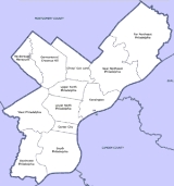
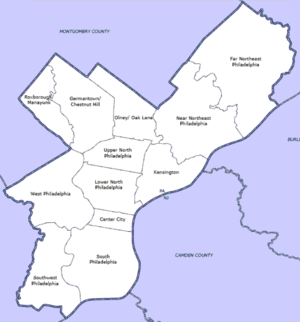
For planning purposes, the city is divided into 12 Planning Analysis Sections.
Center City
Delaware River
The Delaware River is a major river on the Atlantic coast of the United States.A Dutch expedition led by Henry Hudson in 1609 first mapped the river. The river was christened the South River in the New Netherland colony that followed, in contrast to the North River, as the Hudson River was then...
on the east to the Schuylkill River
Schuylkill River
The Schuylkill River is a river in Pennsylvania. It is a designated Pennsylvania Scenic River.The river is about long. Its watershed of about lies entirely within the state of Pennsylvania. The source of its eastern branch is in the Appalachian Mountains at Tuscarora Springs, near Tamaqua in...
on the west.
- Avenue of the ArtsAvenue of the Arts, PhiladelphiaThe Avenue of the Arts is a segment of Broad Street in Philadelphia, Pennsylvania, that includes many of the city's cultural institutions, most notably the theater district south of City Hall....
- CallowhillCallowhill, Philadelphia, PennsylvaniaCallowhill is a neighborhood in Philadelphia, Pennsylvania, USA. It is roughly located in the vicinity of Callowhill Street, between Vine Street, Spring Garden Street, Broad Street, and 8th Street. It is named for Hannah Callowhill Penn, William Penn's second wife...
- Chinatown
- Elfreth's AlleyElfreth's AlleyElfreth's Alley is a residential alley located in Philadelphia, Pennsylvania, in the United States. It is one of the oldest continuously inhabited residential streets in the country, dating back to the early 18th century. It is a National Historic Landmark...
- Fitler SquareFitler SquareFitler Square is a city park in Philadelphia, Pennsylvania, bounded on the east by 23rd Street, on the west by 24th Street, on the north by Panama Street, and on the south by Pine Street...
: north to Locust Street, south to South Street, east to 21st Street, west to the Schuylkill RiverSchuylkill RiverThe Schuylkill River is a river in Pennsylvania. It is a designated Pennsylvania Scenic River.The river is about long. Its watershed of about lies entirely within the state of Pennsylvania. The source of its eastern branch is in the Appalachian Mountains at Tuscarora Springs, near Tamaqua in...
. - FranklintownFranklintown, Philadelphia, PennsylvaniaFranklintown is the name given to the area in Philadelphia, Pennsylvania that lies north of the Vine Street Expressway, south of Spring Garden Street, and west of Broad Street. It is sometimes considered to be the southernmost part of the Spring Garden neighborhood. Franklintown consists of mostly...
- Logan SquareLogan Square, Philadelphia, PennsylvaniaLogan Square is a name given to the area in Philadelphia, Pennsylvania that lies north of Market Street, south of Spring Garden Street, west of Broad Street, and east of the Schuylkill River. This contains the Franklintown neighborhood. It also contains Penn Center and much of Philadelphia's...
- Jewelers' RowJewelers' Row, PhiladelphiaJewelers' Row, located in the Center City section of Philadelphia, Pennsylvania, is composed of more than 300 retailers, wholesalers, and craftsmen on Sansom Street, between Seventh and Eighth streets, and on Eighth Street between Chestnut and Walnut streets....
- Market EastMarket East, Philadelphia, PennsylvaniaMarket East is part of the downtown district known as Center City, Philadelphia, Pennsylvania, United States. Market East corresponds to the area along Market Street between Arch Street to the north, Chestnut Street to the south, Juniper Street to the west, and 6th Street to the east...
- Old CityOld City, Philadelphia, PennsylvaniaOld City is a neighborhood in Center City, Philadelphia, Pennsylvania, United States, in the area near e Delaware River where William Penn and the Quakers first settled...
- Museum District
- Penn CenterPenn Center, Philadelphia, PennsylvaniaPenn Center is the heart of Philadelphia's Central Business District. It derives its name from the nearly five million square foot office and retail complex that helped transform it from a gritty industrial and low-rent commercial district into the centerpiece of Philadelphia's business district in...
- Penn's LandingPenn's LandingPenn's Landing is the waterfront area of the Center City along the Delaware River section of Philadelphia, Pennsylvania, United States. It is so named because the founder of Pennsylvania, William Penn, docked near here in 1682, along the now paved over Dock Creek, after landing first in New...
: encompassed by the DelawareDelaware RiverThe Delaware River is a major river on the Atlantic coast of the United States.A Dutch expedition led by Henry Hudson in 1609 first mapped the river. The river was christened the South River in the New Netherland colony that followed, in contrast to the North River, as the Hudson River was then...
Riverfront. - Rittenhouse SquareRittenhouse SquareRittenhouse Square is one of the five original open-space parks planned by William Penn and his surveyor Thomas Holme during the late 17th century in central Philadelphia, Pennsylvania. The park cuts off 19th Street at Walnut Street and also at a half block above Manning Street. Its boundaries are...
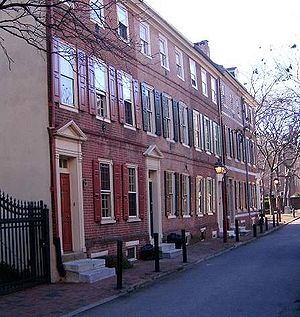
- Society HillSociety Hill, Philadelphia, PennsylvaniaSociety Hill is a neighborhood in the Center City section of Philadelphia, Pennsylvania, United States. The neighborhood, loosely defined as bounded by Walnut, Lombard, Front and 7th Streets, contains the largest concentration of original 18th- and early 19th-century architecture of any place in...
: north to Walnut St., south to Lombard St, east to Front Street, west to 8th St. - South StreetSouth Street (Philadelphia)South Street is an east-west street forming the southern border of the Center City neighborhood of Philadelphia, Pennsylvania and the northern border for the neighborhoods of South Philadelphia. The stretch of South Street between Front Street and Seventh Street is known for its "bohemian"...
: along South Street from Front Street in the east to Seventh Street in the west. - Washington Square WestWashington Square West, Philadelphia, PennsylvaniaThe Gayborhood is a neighborhood in downtown, or Center City, Philadelphia, Pennsylvania. The neighborhood roughly corresponds to the area between 7th and Broad Streets and between Walnut and South Streets, bordering on the Independence Mall tourist area directly northeast, Market East to the...
: north to Market St., south to South St., east to 7th St, west to Broad St. The name derives simply from the fact that this area extends west of Washington SquareWashington Square (Philadelphia)Washington Square, originally designated in 1682 as Southeast Square, is an open-space park in Center City Philadelphia's Southeast quadrant and one of the five original planned squares laid out on the city grid by William Penn's surveyor, Thomas Holme. It is part of both the Washington Square West...
. Recently, this name is used in conjunction with a new name for the neighborhood- Midtown Village. The Gayborhood is entirely within this area.
South PhiladelphiaSouth PhiladelphiaSouth Philadelphia, nicknamed South Philly, is the section of Philadelphia bounded by South Street to the north, the Delaware River to the east and south, and the Schuylkill River to the west.-History:...
- Bella VistaBella Vista, Philadelphia, PennsylvaniaBella Vista, Italian for "beautiful sight", is a neighborhood in the South Philadelphia section of Philadelphia, Pennsylvania.It is bounded by 6th Street, 11th Street, South Street, and Washington Avenue....
: North to South Street, South to Washington Avenue, West to 11th Street, East to 6th Street - Central South PhiladelphiaCentral South Philadelphia, Philadelphia, PennsylvaniaCentral South Philadelphia, commonly known as either just South Philadelphia or "South Philly," is a neighborhood in South Philadelphia. It is generally bounded by Broad to 9th Streets and Mifflin to Shunk . The entire neighborhood falls under the 19148 zip code...
- Devil's PocketDevil's Pocket, Philadelphia, PennsylvaniaDevil's Pocket is a neighborhood in the South Philadelphia section of Philadelphia, Pennsylvania. It is south of Lombard Street, east of 27th Street and north of Washington Avenue, on the western edge of Southwest Center City....
: Irish neighborhood west of Grays Ferry Avenue - Dickinson Narrows - Diverse neighborhood. Washington to Miflin, 4th to 6th. http://www.dickinsonnarrows.org http://dickinsonnarrows.blogspot.com/2006/05/community-meeting-tonight-7pm.html
- East Passyunk CrossingEast Passyunk Crossing, Philadelphia, PennsylvaniaEast Passyunk Crossing is a South Philadelphia neighborhood. Its location is considered to be from Tasker Street to Snyder Avenue, Broad Street to 8th Street.-The New Gayborhood:...
: North to Tasker Street, South to Snyder Avenue, West to Broad Street, East to 9th Street - Franklin Delano Roosevelt ParkFranklin Delano Roosevelt ParkFranklin Delano Roosevelt Park is an aesthetically designed park located along the Delaware River in the southern most point of South Philadelphia, Pennsylvania, comprising some which includes a golf course, about of buildings, roadways, pathways for walking, landscaped architecture, and a...
- Girard EstateGirard Estate, Philadelphia, PennsylvaniaGirard Estate, also known as Girard Estates, is part of South Philadelphia. Its boundaries stretch from Mifflin Street on the north to the south side of Pollock Street on the south, and from the west side of Broad Street on the east to 22nd Street on the west...
- Greenwich
- Grays FerryGrays Ferry, Philadelphia, PennsylvaniaGrays Ferry, also known as Gray's Ferry, is a neighborhood in South Philadelphia bounded by 25th Street on the east, the Schuylkill River on the west, Vare Avenue on the south, and Grays Ferry Avenue on the north. The section of this neighborhood west of 34th Street is also known as The Forgotten...
: north to Gray's Ferry Ave., south to Passyunk Ave., west to the Schuylkill River, east to 24th St. - HawthorneHawthorne, Philadelphia, PennsylvaniaHawthorne is a neighborhood in the South Philadelphia section of Philadelphia, Pennsylvania. It is located between Broad Street and 11th Street, and extends from South Street to Washington Avenue.-Background:...
: from South St. to Washington Ave., Broad St. to 11th St. - Italian MarketItalian Market (Philadelphia)The Italian Market is the popular name for the South 9th Street Curb Market, an area of Philadelphia featuring many grocery shops, cafes, restaurants, bakeries, cheese shops, butcher shops, etc., many with an Italian influence...
: along 9th St. from Fitzwater St. in the north to Wharton St. in the south. - Lower Moyamensing
- Marconi PlazaMarconi Plaza, Philadelphia, PennsylvaniaMarconi Plaza is a neighborhood located in South Philadelphia, Philadelphia, Pennsylvania.An Italian-American enclave, Marconi Plaza has two main halves, East and West, which are divided in the middle by Broad Street. It is located at the most southern end of the city and within the northern...
- MoyamensingMoyamensing, Philadelphia, PennsylvaniaMoyamensing was originally a township on the fast land of the Neck, lying between Passyunk and Wicaco. It was incorporated into the Philadelphia County, Pennsylvania and is today primarily a neighborhood in the South Philadelphia section of Philadelphia, Pennsylvania, United States.-History:The...
- NewboldNewbold, Philadelphia, PennsylvaniaNewbold is a neighborhood in South Philadelphia. Its boundaries are Washington Ave to W. Passyunk Ave, S Broad Street to S 18th Street....
: Washington Ave. to Passyunk Ave., and Broad St. to 18th St.http://www.planphilly.com/area/Newbold_Association - Packer ParkPacker Park, Philadelphia, PennsylvaniaPacker Park is a neighborhood in the South Philadelphia section of Philadelphia, Pennsylvania, United States that includes 1,200 homes built in two unique builder developments of Packer Park 1950s and Brinton Estates 1990s. It is one of four residential communities that form Philadelphia's Sports...
- Passyunk SquarePassyunk Square, Philadelphia, PennsylvaniaPassyunk Square is a neighborhood in South Philadelphia bounded by Broad Street to the west, 6th Street to the east, Tasker Street to the south and Washington Avenue to the north. Passyunk Square is bordered by the Bella Vista, Hawthorne, Central South Philadelphia, Wharton and Point Breeze...
: Washington Ave. to Tasker St., 6th St. to Broad St.http://www.passyunksquare.org/about/ - PennsportPennsport, Philadelphia, PennsylvaniaPennsport is a neighborhood in the South Philadelphia section of Philadelphia, Pennsylvania, United States.Pennsport is home to a large working Irish American population and many Mummer clubs. It was also the site of a controversial push for casinos along the Philadelphia waterfront...
: locally referred to as "Two Street", Penn's Port is a predominantly Irish-American Catholic neighborhood. - Point BreezePoint Breeze, Philadelphia, PennsylvaniaPoint Breeze is a neighborhood in the South Philadelphia section of Philadelphia, Pennsylvania, United States. It is generally bound by 25th Street to the west, Washington Avenue to the north, Broad Street to the east, and Mifflin Street to the south, although the sections between 18th Street and...
- Queen VillageQueen Village, Philadelphia, PennsylvaniaQueen Village is a neighborhood in the South Philadelphia section of Philadelphia, Pennsylvania, just south of the Center City district. It is bounded approximately by Lombard Street to the north , Washington Avenue to the south, the Delaware River to the east, and 6th Street to the west...
: north to Lombard St., south to Washington Ave., east to the Delaware RiverDelaware RiverThe Delaware River is a major river on the Atlantic coast of the United States.A Dutch expedition led by Henry Hudson in 1609 first mapped the river. The river was christened the South River in the New Netherland colony that followed, in contrast to the North River, as the Hudson River was then...
, west to 6th St. - SchuylkillSchuylkill, Philadelphia, PennsylvaniaSchuylkill is a neighborhood in the South Philadelphia region of Philadelphia, Pennsylvania. It has many different names and has also been called Graduate Hospital and Southwest Center City...
- SouthwarkSouthwark, Philadelphia, PennsylvaniaSouthwark was originally the Southwark District, a colonial era municipality in Philadelphia County, Pennsylvania. Today, it is a neighborhood in the South Philadelphia section of Philadelphia, Pennsylvania...
:The limits of the district started on Cedar (South) St. and the Delaware River, and proceeded west to Passyunk Ave.; along the latter to Moyamensing Ave.; then by Keeler’s Lane to Greenwich Road; then to the Delaware River, and along the several courses of the same until reaching the beginning point again. - Southwest Center CitySouthwest Center City, Philadelphia, PennsylvaniaSouthwest Center City is a neighborhood in South Philadelphia bordering Center City, Philadelphia, Pennsylvania. The neighborhood is bordered on the north by South Street, on the south by Washington Avenue, on the west by the Schuylkill River, and by Broad Street on the east...
/ Graduate Hospital: north to South St. (Rittenhouse/Fitler), south to Washington Ave., east to Broad St. (Hawthorne), west to 24th St. (Gray's Ferry)) - Sports ComplexSouth Philadelphia Sports ComplexThe South Philadelphia Sports Complex is the current home of Philadelphia's professional sports teams. It is the site of the Wells Fargo Center, Lincoln Financial Field and Citizens Bank Park...
- Tasker
- WhartonWharton, Philadelphia, PennsylvaniaWharton is a neighborhood in South Philadelphia. Its boundaries are difficult to ascertain; the City of Philadelphia states it is along Wharton Street, west of Pennsport, and east of Point Breeze. According to this description, the neighborhood runs from about 4th Street to Broad, with no clear...
- Whitman
- Wilson Park
- West PassyunkWest Passyunk, Philadelphia, PennsylvaniaWest Passyunk is a neighborhood in South Philadelphia.It is bound by Mifflin Street to the North, West Passyunk Avenue to the South, South 18th Street to East, and South 25th Street to the West. It is served by the 24th Police District, located at 24th and Wolf Streets...
Southwest PhiladelphiaSouthwest PhiladelphiaSouthwest Philadelphia is a section of Philadelphia, Pennsylvania, United States. The section can be described as extending from the western side of the Schuylkill River to the city line, with the SEPTA Media/Elwyn Line serving as the northern border...
- AngoraAngora, Philadelphia, PennsylvaniaAngora is a neighborhood in the Southwest section of Philadelphia, Pennsylvania, United States. Although its boundaries are not precise, West Philadelphia is to its north, Kingsessing is to the south, Cedar Park is to the east, and Cobbs Creek is to the west...
- Bartram VillageBartram Village, Philadelphia, PennsylvaniaBartram Village is a small neighborhood in Southwest Philadelphia. It is located in the vicinity of South 56th Street and Lindbergh Boulevard. The neighborhood takes its name from noted botanist John Bartram, whose historical home and gardens, Bartram's Garden, are located nearby.Bartram Village is...
- ClearviewClearview, Philadelphia, PennsylvaniaClearview is a neighborhood in Southwest Philadelphia. It is located from South 78th Street to South 84th Street, east of Cobbs Creek to Lindbergh Boulevard.-Education:...
- KingsessingKingsessing, Philadelphia, PennsylvaniaKingsessing is a neighborhood in the Southwest section of Philadelphia, Pennsylvania, United States, located adjacent to the neighborhoods of Cedar Park, Southwest Schuykill, and Mount Moriah, as well as Yeadon in Delaware County...
- EastwickEastwick, Philadelphia, PennsylvaniaEastwick is a neighborhood in the Southwest section of Philadelphia, Pennsylvania, United States. It is the southwesternmost neighborhood in the city, bordering Philadelphia International Airport and the city line with Delaware County, Pennsylvania at Cobbs Creek and Darby Creek. The Elmwood Park...
- Elmwood ParkElmwood Park, Philadelphia, PennsylvaniaElmwood Park, also known simply as Elmwood, is a neighborhood in the Southwest section of Philadelphia, Pennsylvania, United States. It borders the city line with Delaware County at Cobbs Creek, and extends to the Schuylkill River...
- Hedgerow
- Hog IslandHog Island, Philadelphia, PennsylvaniaHog Island is the historic name of an area southwest of the central part of Philadelphia, Pennsylvania along the Delaware River, to the west of the mouth of the Schuylkill River. Philadelphia International Airport now sits on the land that was once Hog Island....
: historically the home to a major shipyard, now home to the Philadelphia International AirportPhiladelphia International AirportPhiladelphia International Airport is a major airport in Philadelphia, Pennsylvania, United States, and is the largest airport in the Delaware Valley region and in Pennsylvania... - Mount MoriahMount Moriah, Philadelphia, PennsylvaniaMount Moriah is a neighborhood in Southwest Philadelphia, east of Cobbs Creek in the vicinity of Kingsessing Avenue....
- PaschallPaschall, Philadelphia, PennsylvaniaPaschall is a neighborhood in Southwest Philadelphia. It is located in the vicinity of Cobbs Creek Park and Chester Avenue....
- Philadelphia International AirportPhiladelphia International AirportPhiladelphia International Airport is a major airport in Philadelphia, Pennsylvania, United States, and is the largest airport in the Delaware Valley region and in Pennsylvania...
- Penrose
- Southwest SchuykillSouthwest Schuylkill, Philadelphia, PennsylvaniaSouthwest Schuylkill is a neighborhood in Southwest Philadelphia, along the Schuylkill River north of Elmwood, in the vicinity of the Southeastern Pennsylvania Transportation Authority's R3 railroad tracks....
West PhiladelphiaWest PhiladelphiaWest Philadelphia, nicknamed West Philly, is a section of Philadelphia, Pennsylvania. Though there is no official definition of its boundaries, it is generally considered to reach from the western shore of the Schuylkill River, to City Line Avenue to the northwest, Cobbs Creek to the southwest, and...
- Belmont DistrictBelmont District, PennsylvaniaBelmont District is a defunct district that was located in Philadelphia County, Pennsylvania. The district ceased to exist and was incorporated into the City of Philadelphia following the passage of the Act of Consolidation, 1854....
: defunct - Belmont Village
- Carroll ParkCarroll Park, Philadelphia, PennsylvaniaCarroll Park is a neighborhood in West Philadelphia. Its boundaries are Lansdowne Avenue to the north, West Girard Avenue to the south, North 63rd Street to the west, and North 52nd Street to the east....
- Cathedral ParkCathedral Park, Philadelphia, PennsylvaniaCathedral Park is a small neighborhood in the West Philadelphia section of Philadelphia, Pennsylvania, United States. Its boundaries are North 52nd Street to the west and north, West Girard Avenue and the Old Cathedral Cemetery to the south, and the SEPTA regional rail tracks to the east...
- Cedar ParkCedar Park, Philadelphia, PennsylvaniaCedar Park is a neighborhood located in the West Philadelphia section of Philadelphia, Pennsylvania. It was built as a streetcar suburb for Center City between 1850 and 1910. It is a racially and ethnically diverse part of the city, with much of the historic architecture preserved...
- Cobbs CreekCobbs Creek, Philadelphia, PennsylvaniaCobbs Creek is a predominantly African American neighborhood located in the West Philadelphia section of Philadelphia, Pennsylvania, United States . Cobbs Creek is generally bound by Market Street to the north, Baltimore Ave. to the south, 52nd Street to the east, and Cobbs Creek to the west...
: East to 52nd Street, west to Cobbs Creek, north to Market Street, south to Baltimore Avenue - DunlapDunlap, Philadelphia, PennsylvaniaThe neighborhood of Dunlap is situated in present day West Philadelphia. The neighborhood lies in the vicinity of Haverford Avenue and Market Street and stretches from 46th to 52nd streets....
- Garden CourtGarden Court, Philadelphia, PennsylvaniaGarden Court is a neighborhood in the West Philadelphia section of Philadelphia, Pennsylvania. It is located west of Spruce Hill, north of Cedar Park, east of Cobbs Creek, and south of Walnut Hill....
- HaddingtonHaddington, Philadelphia, PennsylvaniaHaddington is a neighborhood in the West Philadelphia section of Philadelphia, Pennsylvania. It is arguably located between 52nd Street and 63rd Street, bounded by Chestnut Street and Girard Avenue....
- Haverford North
- MantuaMantua, Philadelphia, PennsylvaniaMantua is a neighborhood in the West Philadelphia section of Philadelphia, Pennsylvania. It is located north of Spring Garden Street, east of 40th Street, south of Mantua Avenue, and west of 31st Street...
- Mill CreekMill Creek, Philadelphia, PennsylvaniaMill Creek is a neighborhood in the West Philadelphia section of Philadelphia, Pennsylvania. It is located north of Market Street, south of Girard Avenue, between 44th and 52nd Streets. It is named for the eponymous creek which was covered by a cistern in the 1880s, although the water underneath...
- OverbrookOverbrook, Philadelphia, PennsylvaniaOverbrook is a neighborhood northwest of West Philadelphia, Philadelphia, Pennsylvania. The area contains an assortment of housing from large, old homes to row homes to 3-4 story apartment buildings.-Physical setting:...
- Overbrook ParkOverbrook Park, Philadelphia, PennsylvaniaOverbrook Park is a neighborhood in the West Philadelphia section of Philadelphia, Pennsylvania, United States. It was founded in the 1940s on the site of a former farm, offering new housing for returning GIs and their families...
- Overbrook FarmsOverbrook Farms, Philadelphia, PennsylvaniaOverbrook Farms is a neighborhood on the western edge of the West Philadelphia section of Philadelphia, Pennsylvania, United States. Roughly bounded by City Avenue , 58th Street, Woodbine Avenue, and 66th Street at Morris Park...
- ParksideParkside, Philadelphia, PennsylvaniaParkside is a neighborhood in the West Philadelphia section of Philadelphia, Pennsylvania.Much of the Parkside neighborhood was built during the 1876 Centennial Exhibition. It is a National Register of Historic Places Historic District with many examples of Victorian architecture, some...
- Powelton VillagePowelton Village, Philadelphia, PennsylvaniaPowelton Village is a neighborhood of mostly Victorian, mostly twin homes in the West Philadelphia section of the United States city of Philadelphia, Pennsylvania. It is a national historic district which is part of University City...
- Saunders ParkSaunders Park, Philadelphia, PennsylvaniaSaunders Park is a neighborhood in the West Philadelphia section of Philadelphia, Pennsylvania. It is bounded by Powelton Avenue, 38th Street, Lancaster Avenue, and 40th Street. It is west of Powelton Village and north of Spruce Hill....
- Spruce HillSpruce Hill, Philadelphia, PennsylvaniaSpruce Hill is a neighborhood in the West Philadelphia section of Philadelphia, Pennsylvania. It is between 40th and 46th streets, and it stretches from Market Street south to Woodland Avenue. It has a population of over 16,000. It was built as a streetcar suburb for Center City between 1850 and...
- Squirrel HillSquirrel Hill, Philadelphia, PennsylvaniaSquirrel Hill is a neighborhood in West Philadelphia, south of Baltimore Ave and west of Clark Park. It shares a border with the Spruce Hill and Cedar Park neighborhoods. By some accounts, this neighborhood is within the boundaries of the University City district.Squirrel Hill has the distinction...
- University CityUniversity City, Philadelphia, PennsylvaniaUniversity City is the easternmost region of West Philadelphia.The University of Pennsylvania has long been the dominant institution in the area and was instrumental in coining the name University City as part of a 1950s urban-renewal effort...
- Walnut HillWalnut Hill, Philadelphia, PennsylvaniaWalnut Hill is a neighborhood in the West Philadelphia section of Philadelphia, Pennsylvania. It is located between 45th Street and 52nd Street, bounded by Market Street and Spruce Street. Most of the neighborhood is in the northwestern part of the University City District...
- Woodland TerraceWoodland Terrace, Philadelphia, PennsylvaniaWoodland Terrace is a street name and a small neighborhood of Italianate twin mansions in the West Philadelphia section of Philadelphia, Pennsylvania...
- WynnefieldWynnefield, Philadelphia, PennsylvaniaWynnefield is a predominantly African-American, middle-classneighborhood in West Philadelphia. Its borders are 53rd Street at Jefferson to the south, Philadelphia's Fairmount Park to the east, City Avenue to the north and the Amtrak Main Line tracks to the west.Surrounding neighborhoods include...
: East to 53rd Street and Fairmount ParkFairmount ParkFairmount Park is the municipal park system of Philadelphia, Pennsylvania. It consists of 63 parks, with , all overseen by the Philadelphia Department of Parks and Recreation, successor to the Fairmount Park Commission in 2010.-Fairmount Park proper:...
, West to 59th Street, North to City Avenue, south to Fairmount ParkFairmount ParkFairmount Park is the municipal park system of Philadelphia, Pennsylvania. It consists of 63 parks, with , all overseen by the Philadelphia Department of Parks and Recreation, successor to the Fairmount Park Commission in 2010.-Fairmount Park proper:... - Wynnefield Heights
University CityUniversity City, Philadelphia, PennsylvaniaUniversity City is the easternmost region of West Philadelphia.The University of Pennsylvania has long been the dominant institution in the area and was instrumental in coining the name University City as part of a 1950s urban-renewal effort...
Generally speaking, University City is the section of West Philadelphia surrounding Drexel UniversityDrexel University
Drexel University is a private research university with the main campus located in Philadelphia, Pennsylvania, USA. It was founded in 1891 by Anthony J. Drexel, a noted financier and philanthropist. Drexel offers 70 full-time undergraduate programs and accelerated degrees...
and the University of Pennsylvania
University of Pennsylvania
The University of Pennsylvania is a private, Ivy League university located in Philadelphia, Pennsylvania, United States. Penn is the fourth-oldest institution of higher education in the United States,Penn is the fourth-oldest using the founding dates claimed by each institution...
. More specifically, it runs East to the Schuylkill River
Schuylkill River
The Schuylkill River is a river in Pennsylvania. It is a designated Pennsylvania Scenic River.The river is about long. Its watershed of about lies entirely within the state of Pennsylvania. The source of its eastern branch is in the Appalachian Mountains at Tuscarora Springs, near Tamaqua in...
and Interstate 76
Interstate 76 (east)
Interstate 76 is an Interstate Highway in the United States, running 435 miles from an interchange with Interstate 71 west of Akron, Ohio, east to Interstate 295 near Camden, New Jersey....
(Schuylkill Expressway), North to Powelton Ave., South to the Schuylkill river and the Media line railroad (R3), and West to around 52nd Street.
- Black BottomBlack Bottom (Philadelphia)Black Bottom was a predominantly African American neighborhood in Philadelphia, Pennsylvania that was razed for urban renewal in the 1950s and 1960s.-History:...
: Not current; formerly around the area of 38th and Market Sts. - Cedar ParkCedar Park, Philadelphia, PennsylvaniaCedar Park is a neighborhood located in the West Philadelphia section of Philadelphia, Pennsylvania. It was built as a streetcar suburb for Center City between 1850 and 1910. It is a racially and ethnically diverse part of the city, with much of the historic architecture preserved...
: north to Larchwood Ave., south to Baltimore Ave., east to 46th St., west to 52nd St. - Garden CourtGarden Court, Philadelphia, PennsylvaniaGarden Court is a neighborhood in the West Philadelphia section of Philadelphia, Pennsylvania. It is located west of Spruce Hill, north of Cedar Park, east of Cobbs Creek, and south of Walnut Hill....
: north to Locust St., south to Cedar Ave., east to 46th St., west to 52nd St. - Powelton VillagePowelton Village, Philadelphia, PennsylvaniaPowelton Village is a neighborhood of mostly Victorian, mostly twin homes in the West Philadelphia section of the United States city of Philadelphia, Pennsylvania. It is a national historic district which is part of University City...
: north to Spring Garden St., south to Market St., east to 32nd St., west to 44th St. - Spruce HillSpruce Hill, Philadelphia, PennsylvaniaSpruce Hill is a neighborhood in the West Philadelphia section of Philadelphia, Pennsylvania. It is between 40th and 46th streets, and it stretches from Market Street south to Woodland Avenue. It has a population of over 16,000. It was built as a streetcar suburb for Center City between 1850 and...
: North to Market, South to Baltimore Ave., East to 40th, West to around 46th. - Squirrel HillSquirrel Hill, Philadelphia, PennsylvaniaSquirrel Hill is a neighborhood in West Philadelphia, south of Baltimore Ave and west of Clark Park. It shares a border with the Spruce Hill and Cedar Park neighborhoods. By some accounts, this neighborhood is within the boundaries of the University City district.Squirrel Hill has the distinction...
: North to Baltimore Ave., South to Woodland Ave., East to 45rd St., West to 50th St. - Walnut HillWalnut Hill, Philadelphia, PennsylvaniaWalnut Hill is a neighborhood in the West Philadelphia section of Philadelphia, Pennsylvania. It is located between 45th Street and 52nd Street, bounded by Market Street and Spruce Street. Most of the neighborhood is in the northwestern part of the University City District...
: North to Market St., South to Larchwood Ave., East to 46th St., West to 52nd St. - Woodland TerraceWoodland Terrace, Philadelphia, PennsylvaniaWoodland Terrace is a street name and a small neighborhood of Italianate twin mansions in the West Philadelphia section of Philadelphia, Pennsylvania...
: North to Baltimore Ave., South to Woodland Ave., East to 40th St., West to 43rd St.
Northwest PhiladelphiaNorthwest PhiladelphiaNorthwest Philadelphia is a section of the city of Philadelphia, Pennsylvania. The official boundary is Stenton Avenue to the north, the Schuylkill river to the south, Spring Ln to the west, and Wister Street to the east. The area is divided by Wissahickon Creek into two subsections...
Germantown, Chestnut Hill Planning Analysis Section
- Chestnut Hill
- GermantownGermantown, Philadelphia, PennsylvaniaGermantown is a neighborhood in the northwest section of the city of Philadelphia, Pennsylvania, United States, about 7–8 miles northwest from the center of the city...
- MortonMorton, Philadelphia, PennsylvaniaMorton is a neighborhood in Northwest Philadelphia. It is located south of West Oak Lane, east of Mount Airy, and west of North Broad Street.- References :...
- WisterWister, Philadelphia, PennsylvaniaWister is a neighborhood in Northwest Philadelphia. It is bounded by Stenton Avenue to the north, Germantown Avenue to the south, Belfield Avenue to the east, and East Chelten Avenue to the west.-References:...
- West Oak LaneWest Oak Lane, Philadelphia, PennsylvaniaWest Oak Lane is a neighborhood in the Northwest Philadelphia section of Philadelphia. It is located between East Mount Airy, East Germantown, Cheltenham, Montgomery County, East Oak Lane, and Fern Rock. Ogontz Avenue runs generally north, then northwest as the spine of the neighborhood and the...
- CedarbrookCedarbrook, Philadelphia, PennsylvaniaCedarbrook is a neighborhood located in the North Philadelphia section of Philadelphia, Pennsylvania, United States. It is also sometimes said to be in Northwest Philadelphia, owing to its rather northwestern location on Philadelphia's letter-y-like outline....
- West Mount Airy
Roxborough, Manayunk Planning Analysis Section
- AndorraAndorra, Philadelphia, PennsylvaniaAndorra is a neighborhood in Northwest Philadelphia, which is a section of the city of Philadelphia, Pennsylvania. Andorra is a part of Roxborough, being within the borders of the original Roxborough Township and having the same zip code . At some point during the 19th or 20th century, Andorra...
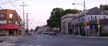
- East FallsEast Falls, Philadelphia, PennsylvaniaEast Falls is a neighborhood in the Northwest section of Philadelphia, Pennsylvania, United States. East Falls is located adjacent to Roxborough, Manayunk, and Germantown, and Fairmount Park. The neighborhood runs along a stretch of Ridge Avenue that is only a few miles long, along the banks of the...
- ManayunkManayunk, Philadelphia, PennsylvaniaManayunk is a neighborhood in the northwestern section of the city of Philadelphia, Pennsylvania in the United States. Located on the banks of the Schuylkill River, it contains the first canal begun in the United States . The area's name comes from the language of the Lenape Indians...
- RoxboroughRoxborough, Philadelphia, PennsylvaniaRoxborough is a neighborhood in the Northwest Philadelphia section of the United States city of Philadelphia, Pennsylvania. It is bordered to the southwest, along the Schuylkill River, by the neighborhood of Manayunk, along the northeast by the Wissahickon Creek section of Fairmount Park, and to...
- WissahickonWissahickon, Philadelphia, PennsylvaniaWissahickon is the informal name given to the areas of Mt. Airy, and Germantown close to Fairmount Park in northwest Philadelphia. Many larger Georgian Revival homes sit in the area. Neighborhoods like Blue Bell Hill Wissahickon is the informal name given to the areas of Mt. Airy, and Germantown...
- East Mount Airy
Lower North Philadelphia Planning Analysis Section
- BrewerytownBrewerytown, Philadelphia, PennsylvaniaBrewerytown is a neighborhood in the North Philadelphia district of the city of Philadelphia, Pennsylvania, United States. An unofficial region, Brewerytown runs approximately between the Schuylkill River's eastern bank and 25th Street, bounded by Cecil B. Moore Avenue to the north and Parrish...
- Cabot
- FairhillFairhill, Philadelphia, PennsylvaniaFairhill is a neighborhood on the east side of the North Philadelphia section of Philadelphia, Pennsylvania, United States. Fairhill is located in an area between Kensington Avenue and 6th Street ranging from York Street to Gurney Street/Clearfield Street...
- FairmountFairmount, Philadelphia, PennsylvaniaFairmount is a United States neighborhood in the North Philadelphia area of Philadelphia, Pennsylvania. The name "Fairmount" itself derives from the prominent hill on which the Philadelphia Museum of Art now sits, and where William Penn originally intended to build his own manor house...
: North to Girard Avenue, South to Vine Street, East to Broad Street, West to Schuylkill RiverSchuylkill RiverThe Schuylkill River is a river in Pennsylvania. It is a designated Pennsylvania Scenic River.The river is about long. Its watershed of about lies entirely within the state of Pennsylvania. The source of its eastern branch is in the Appalachian Mountains at Tuscarora Springs, near Tamaqua in... - FrancisvilleFrancisville, Philadelphia, PennsylvaniaFrancisville is a neighborhood in North Philadelphia, which is a section of the city of Philadelphia, Pennsylvania. Its boundaries are Fairmount Avenue to the south, Girard Avenue to the north, Broad Street to the east, and Corinthian Avenue to the west. In 2000, it had a population of about 4,500...
- HartranftHartranft, Philadelphia, PennsylvaniaHartranft is a neighborhood in the central part of North Philadelphia section of Philadelphia, Pennsylvania, United States.Hartranft is on the border of the predominantly Black central region of North Philadelphia and the predominantly Hispanic eastern region of North Philadelphia. Bounded by 10th...
- LudlowLudlow, Philadelphia, PennsylvaniaThe neighborhood of Ludlow is a small neighborhood in Philadelphia, Pennsylvania. It is bordered by Girard Avenue to the south and Cecil B. Moore Avenue to the north. It extends from 5th Street west to 10th Street....
- North CentralNorth Central, Philadelphia, PennsylvaniaNorth Central is an area in the North Philadelphia section of Philadelphia, Pennsylvania, United States. The name of the area is derived from its location, near the center of North Philadelphia. According to Census 2010 North Central is primarily a low-income neighborhood where 60% of its residents...
- Northern LibertiesNorthern Liberties, Philadelphia, Pennsylvania-Boundaries:Northern Liberties is located north of Center City and is bordered by Girard Avenue to the north; Callowhill Street to the south; North 6th Street to the west; and the Delaware River to the east...
: North to Girard Avenue, South to Spring Garden Street, East to Delaware RiverDelaware RiverThe Delaware River is a major river on the Atlantic coast of the United States.A Dutch expedition led by Henry Hudson in 1609 first mapped the river. The river was christened the South River in the New Netherland colony that followed, in contrast to the North River, as the Hudson River was then...
, West to 6th Street - PoplarPoplar, Philadelphia, PennsylvaniaPoplar is a neighborhood in North Philadelphia. It is located north of Chinatown, between Spring Garden and Northern Liberties, bound roughly by Girard Avenue to the north, North Broad Street to the West, Spring Garden Street to the south, and 5th Street to the east...
- SharswoodSharswood, Philadelphia, PennsylvaniaSharswood is a small neighborhood in the North Philadelphia section of the city of Philadelphia, Pennsylvania. It is located to the east of Brewerytown, north of Girard College, west of Ridge Avenue, and south of the Norman Blumberg apartment towers...
- Spring GardenSpring Garden, Philadelphia, PennsylvaniaSpring Garden is a neighborhood in the central Philadelphia, Pennsylvania, USA, bordering Center City on the north. Spring Garden is a neighborhood that combines diverse residential neighborhoods and significant cultural attractions...
- South Lehigh
- StantonStanton, Philadelphia, PennsylvaniaStanton is a neighborhood located between North Broad Street and Strawberry Mansion in North Philadelphia. Stanton is predominately African American, with a growing number of Puerto Ricans and Whites....
- Strawberry MansionStrawberry Mansion, Philadelphia, PennsylvaniaStrawberry Mansion is a neighborhood in the United States city of Philadelphia, Pennsylvania, located east of Fairmount Park in North Philadelphia. It has a large and predominantly African-American population. The neighborhood is bounded by 33rd Street in the west, 29th Street in the east, Lehigh...
- TempletownTempletown, Philadelphia, PennsylvaniaTempletown is a neighborhood in the North Philadelphia section of the city of Philadelphia, Pennsylvania, United States. The district is loosely arranged around the main campus of Temple University, hence the name 'Temple' town. Until recently, the area was primarily a slum, but is now rapidly...
(Temple UniversityTemple UniversityTemple University is a comprehensive public research university in Philadelphia, Pennsylvania, United States. Originally founded in 1884 by Dr. Russell Conwell, Temple University is among the nation's largest providers of professional education and prepares the largest body of professional...
Area) - YorktownYorktown, Philadelphia, PennsylvaniaYorktown is a neighborhood in North Philadelphia. It is located north of Poplar and west of Ludlow....
Upper North Philadelphia Planning Analysis Section
- Allegheny WestAllegheny West, Philadelphia, PennsylvaniaAllegheny West is a neighborhood in the North Philadelphia section of Philadelphia. It is named after an association formed by Pep Boys and Tasty Baking Company, among others, and the community bordering East Falls, Strawberry Mansion and Germantown...
- FranklinvilleFranklinville, Philadelphia, PennsylvaniaFranklinville is a neighborhood of North Philadelphia, Pennsylvania. According to the City Planning Commission, the boundaries of Franklinville are roughly a triangle bounded by West Sedgley Avenue, North Broad Street, and West Hunting Park Avenue....
- GlenwoodGlenwood, Philadelphia, PennsylvaniaGlenwood is a neighborhood in North Philadelphia. It is located in the vicinity of North Philadelphia Station to West York Street.In 1988 two residents of the 3100 block of Percy Street, Reverend Clarence Hester, a Baptist minister and activist, and Carrie Hartsfield, an insurance worker who...
- Hunting ParkHunting Park, Philadelphia, PennsylvaniaHunting Park is a neighborhood in the North Philadelphia section of the United States city of Philadelphia, Pennsylvania. Like many North Philadelphia neighborhoods, it grew mainly in the 1920s and 1940s. The neighborhood's namesake is large park which is a regular location for recreation for many...
- Nicetown-TiogaNicetown-Tioga, Philadelphia, PennsylvaniaNicetown-Tioga is a neighborhood in the North Philadelphia section of the city of Philadelphia, in the U.S. state of Pennsylvania. It comprises two smaller, older neighborhoods, Nicetown and Tioga, although the distinction between the two is rarely emphasized today...
- Olde KensingtonOlde Kensington, Philadelphia, PennsylvaniaOlde Kensington is a neighborhood located in the Kensington section of Philadelphia, Pennsylvania, United States. Olde Kensington is north of Northern Liberties, south of West Kensington, east of Ludlow, and west of Fishtown. The boundaries of the neighborhood are roughly between Cecil B Moore Ave...
- West KensingtonWest Kensington, Philadelphia, PennsylvaniaWest Kensington is a neighborhood in the North Philadelphia section of Philadelphia. It is north of Olde Kensington. The Market Frankford El above Front Street forms the line between West Kensington and its bordering neighborhoods to the east , although its other boundaries are less well-defined...
Olney, Oak Lane Planning Analysis Section
- East Oak LaneEast Oak Lane, Philadelphia, PennsylvaniaEast Oak Lane is a neighborhood in the upper Northern section of Philadelphia, Pennsylvania, United States. Many of the houses in the neighborhood are large single homes or twins built at a later period than much of central North Philadelphia...
- FeltonvilleFeltonville, Philadelphia, PennsylvaniaFeltonville is a neighborhood in Northeast Philadelphia It is located east of Logan, Philadelphia, south of Olney, northeast of Hunting Park, west of Frankford, and northwest of Juniata...
- Fern RockFern Rock, Philadelphia, Pennsylvaniathumb|Fern Rock Transportation CenterFern Rock is a neighborhood in the upper North Philadelphia section of Philadelphia, Pennsylvania bounded by Olney to the east, Ogontz to the west, Logan to south, and East Oak Lane to the north. It is approximately situated between Broad Street, Tabor Road, 7th...
- LoganLogan, Philadelphia, PennsylvaniaLogan is a neighborhood in the upper North Philadelphia section of the city of Philadelphia, in the U.S. state of Pennsylvania. Philadelphians usually define Logan as being bounded by Wingohocking Street to the south, Olney Avenue to the north, Broad Street to the east, and to 16th Street to the...
- Melrose Park
- OgontzOgontz, Philadelphia, PennsylvaniaOgontz is a neighborhood in the North Philadelphia section of Philadelphia, Pennsylvania, United States that borders suburban Cheltenham Township, Montgomery County....
- OlneyOlney, Philadelphia, PennsylvaniaOlney is a neighborhood in the North Philadelphia section of Philadelphia, Pennsylvania, United States. It is roughly bounded by the Roosevelt Boulevard to the south, Tacony Creek to the east, Godfrey Avenue to the north, and the railroad right-of-way west of Sixth Street to the west.Although...
- West Oak LaneWest Oak Lane, Philadelphia, PennsylvaniaWest Oak Lane is a neighborhood in the Northwest Philadelphia section of Philadelphia. It is located between East Mount Airy, East Germantown, Cheltenham, Montgomery County, East Oak Lane, and Fern Rock. Ogontz Avenue runs generally north, then northwest as the spine of the neighborhood and the...
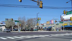
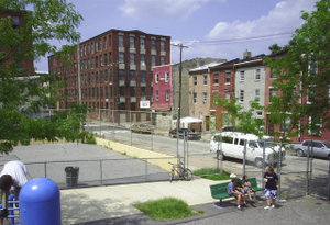
The NortheastNortheast PhiladelphiaNortheast Philadelphia, nicknamed Northeast Philly, the Northeast and the Great Northeast, is a section of the city of Philadelphia, Pennsylvania. According to the 2000 Census, the Northeast has a sizable percentage of the city's 1.547 million people — a population of between 300,000 and 450,000,...
The Far Northeast
- Academy GardensAcademy Gardens, Philadelphia, PennsylvaniaAcademy Gardens is a neighborhood located in the The Northeast section of Philadelphia, Pennsylvania, United States. It is located on the eastern side of the Far Northeast. Its approximate boundaries are Pennypack Park, Grant Avenue, the John F. Byrne Golf Course, and Holme Avenue...
- Ashton-WoodenbridgeAshton-Woodenbridge, Philadelphia, PennsylvaniaAshton-Woodenbridge is a neighborhood in the Northeast section of Philadelphia, Pennsylvania. It is located on the eastern side of the Far Northeast, in the vicinity of Northeast Philadelphia Airport, including Wooden Bridge Run west to Academy Gardens, and south to Pennypack Park...
- BustletonBustleton, Philadelphia, PennsylvaniaThe Bustleton section of Northeast Philadelphia is located in the Far Northeast, north of Rhawnhurst and Fox Chase and south of Somerton; sitting between Roosevelt Boulevard to the east, the city boundary to the west, Red Lion Road to the north, and Pennypack Park to the south, it is centered at...
- ByberryByberry, Philadelphia, PennsylvaniaByberry is a place name in Northeast Philadelphia that can have several references.Byberry is a neighborhood in the far northeast section of Philadelphia, Pennsylvania...
- Crestmont FarmsCrestmont Farms, Philadelphia, PennsylvaniaCrestmont Farms is an affluent small residential neighborhood in the Northeast section of Philadelphia, Pennsylvania. It is located along the Bucks County line, at Poquessing Creek, east of Knights Road. The housing consists of single homes....
- Krewstown
- MillbrookMillbrook, Philadelphia, PennsylvaniaMillbrook, also known as Chalfont, is a neighbourhood in the Northeast section of Philadelphia, Pennsylvania, United States. The neighborhood is adjacent to Franklin Mills.The neighborhood consists of row homes, twin and twin rancher homes and has subdivision names such as Robindale, Chalfont, and...
- Modena ParkModena Park, Philadelphia, Pennsylvania-Modena Park:is a neighborhood in Northeast Philadelphia. It is located east of Northeast Philadelphia Airport at Morrell Avenue. The ground was owned by the estate of William Dudley in 1910. The neighborhood was built around 1960-1963, and features short blocks of two story rowhouses with...
- Morrell ParkMorrell Park, Philadelphia, PennsylvaniaMorrell Park is a neighborhood located in the Northeast section of Philadelphia, Pennsylvania, United States. It is located on the eastern side of the Far Northeast, north of Grant Avenue and east of Northeast Philadelphia Airport.-Characteristics:...
- NormandyNormandy, Philadelphia, PennsylvaniaNormandy is a neighborhood in Northeast Philadelphia. It is located east of Roosevelt Boulevard, in the vicinity of Woodhaven and Byberry Roads, built in 1955- 1956. All of the streets in this neighborhood begin with the letter N. The neighborhood is made up of cape cod style single family homes,...
- Parkwood
- PennypackPennypack, Philadelphia, PennsylvaniaPennypack is a neighborhood in Northeast Philadelphia. It is located between Northeast Philadelphia Airport and Pennypack Park....
- SomertonSomerton, Philadelphia, PennsylvaniaSomerton is located in the Far Northeast section of Philadelphia, Pennsylvania, United States. The neighborhood is generally bound by Red Lion Road to the south, Roosevelt Boulevard to the east, East County Line Road and Poquessing Creek to the north, and the Philadelphia County / Montgomery County...
- TorresdaleTorresdale, Philadelphia, PennsylvaniaThis article is about a place in Pennsylvania; for the United Kingdom locations, see Torrisdale Torresdale, also formerly known as Torrisdale, is a neighborhood in the Far Northeast section of Philadelphia, Pennsylvania...
- Upper HolmesburgUpper Holmesburg, Philadelphia, PennsylvaniaUpper Homlmesburg is a neighborhood in Northeast Philadelphia. It is located along the Delaware River and Pennypack Creek, from Frankford Avenue to Willits Road....
- Winchester ParkWinchester Park, Philadelphia, PennsylvaniaWinchester Park is a neighborhood in Northeast Philadelphia. It is located in the vicinity of Pennypack Park, north of Holmesburg.It is primarily a neighborhood of single family homes, south of Welsh Road, built between 1947- 1955, and twin homes north of Welsh Road, built around 1960. St Jerome...
The Near Northeast
- BurholmeBurholme, Philadelphia, PennsylvaniaBurholme is a neighborhood in the Northeast section of Philadelphia, Pennsylvania, United States.The neighborhood is adjacent to Burholme Park, which is located in the Fox Chase section of Philadelphia.-External links:**...
- Castor GardenCastor Garden, Philadelphia, PennsylvaniaCastor Gardens is a neighborhood in the lower Northeast section of Philadelphia, Pennsylvania, USA. Castor Gardens' borders are ill-defined, but it exists in the vicinity of Castor and Cottman Avenues. It is also near Roosevelt Boulevard...
- CrescentvilleCrescentville, Philadelphia, PennsylvaniaCrescentville is a neighborhood in Northeast Philadelphia. It is located in the vicinity of Adams, Rising Sun, and Tabor Avenues.Crescentville is referred to as the area bound by Tookany Creek to the South and West of Adams Avenue, up to the intersection of Comly and Rising Sun Avenues and to...
- Fox ChaseFox Chase, Philadelphia, PennsylvaniaFox Chase is a neighborhood in the Northeast Philadelphia section of the United States city of Philadelphia, Pennsylvania. The origin of the name comes from The "Fox Chase Inn" which opened in 1705...
- FrankfordFrankford, Philadelphia, PennsylvaniaFrankford is a large and important neighborhood in the lower Northeast section of Philadelphia situated about six miles northeast of Center City. Although its borders are vaguely defined, the neighborhood is bounded roughly by the original course of Frankford Creek, now roughly Adams to Aramingo...
- Holme CircleHolme Circle, Philadelphia, PennsylvaniaHolme Circle is a neighborhood in Northeast Philadelphia. It is located in the loop of Pennypack Creek at Holme Avenue and Welsh Road. The area is generally composed of two-story twin homes north of the Holme Circle , one-story twins southeast of the Circle and single...
- HolmesburgHolmesburg, Philadelphia, PennsylvaniaHolmesburg is a neighborhood in the Northeast section of Philadelphia, Pennsylvania. Holmesburg was named for the descendants of John Holme who immigrated to Philadelphia in the 1680s and had no known relation to Surveyor General Thomas Holme. John Holme's descendants acquired land in Lower...
- JuniataJuniata, Philadelphia, PennsylvaniaJuniata is a neighborhood in Northeast Philadelphia, which is a section of the city of Philadelphia, Pennsylvania; however, it is sometimes said to be in North Philadelphia because it lies west of Frankford Creek. Juniata is located south of the Juniata Golf Club in Tacony Creek Park...
- LawncrestLawncrest, Philadelphia, PennsylvaniaLawncrest is a neighborhood in the "Near" Northeast Philadelphia, Pennsylvania. The name is an amalgram of Lawndale and Crescentville, the two primary communities that make up the neighborhood....
- LawndaleLawndale, Philadelphia, PennsylvaniaLawndale is a neighborhood in Northeast Philadelphia. It is located near Rising Sun and Oxford avenues and is south of Cottman Avenue.Despite the city's notation on the link below, Lawndale originally was named back in the 1880s...
- Lexington ParkLexington Park, Philadelphia, PennsylvaniaLexington Park is a neighborhood in the Northeast section of Philadelphia, Pennsylvania. It is bounded on the west by Roosevelt Boulevard, and on the north, east and south by Pennypack Park. The neighborhood is made up mostly of twin and single homes built in the years following the Second World...
- MayfairMayfair, Philadelphia, PennsylvaniaMayfair is a neighborhood located in the Lower Northeast section of Philadelphia, Pennsylvania centered on the intersection of Cottman and Frankford Avenues...
- NorthwoodNorthwood, Philadelphia, PennsylvaniaNorthwood is bounded on the north by Roosevelt Boulevard, on the northeast by Cheltenham Avenue, on the west by Oakland Cemetery and Greenwood Cemetery, Juniata Park and Frankford Creek, and on the southeast by Frankford Avenue. To the northeast are Oxford Circle and Mayfair and to the southeast...
- Oxford CircleOxford Circle, Philadelphia, PennsylvaniaOxford Circle is a neighborhood in the lower Northeast section of Philadelphia, Pennsylvania, United States. Its namesake is the much used traffic circle...
- RhawnhurstRhawnhurst, Philadelphia, PennsylvaniaRhawnhurst is a residential neighborhood in the Northeast section of Philadelphia, named for George and William Rhawn by area real estate developers. Roughly bordered by Cottman Avenue to the south, Pennway Street to the west, the Pennypack Creek to the north, and Roosevelt Boulevard to the east,...
- RyersRyers, Philadelphia, PennsylvaniaRyers is a neighborhood in Northeast Philadelphia. Ryers is bounded by Cottman Avenue on the southwest, Fillmore Street on the northwest. Both of these highways separate Philadelphia from Cheltenham and Rockledge, Montgomery County. The Fox Chase Line separates Ryers from Burholme and Fox Chase...
- TaconyTacony, Philadelphia, PennsylvaniaTacony is a historic neighborhood in Northeast Philadelphia, about from downtown Philadelphia. It is the oldest continuously occupied neighborhood in Philadelphia. It is bounded by Frankford Avenue on the northwest, Cottman Avenue on the northeast, Levick Street on the southwest, and the...
- WissinomingWissinoming, Philadelphia, PennsylvaniaWissinoming is a neighborhood in the Near Northeast section of Philadelphia, Pennsylvania. It is bordered by Mayfair and Tacony on the north, Bridesburg on the south, I-95 and the Delaware River on the east, and Frankford on the west. Wissinoming uses the ZIP codes 19135 and 19124...
Kensington, Port Richmond, Bridesburg Planning Analysis Section
- BridesburgBridesburg, Philadelphia, PennsylvaniaBridesburg is the last river-front neighborhood before the Northeast section of Philadelphia, Pennsylvania, United States begins. Bridesburg has a significant Polish community and continues to be a destination from incoming immigrants from Poland to live...
- FishtownFishtown, Philadelphia, PennsylvaniaFishtown is a neighborhood in Philadelphia, Pennsylvania, United States. Located immediately northeast of Center City, its borders are somewhat disputed today due to many factors, but are roughly defined by the triangle created by the Delaware River, Frankford Avenue, and York Street...
- HarrowgateHarrowgate, Philadelphia, PennsylvaniaHarrowgate is a neighborhood in the Northeast section of Philadelphia, Pennsylvania, United States. Harrowgate is located northeast of Kensington adjacent to Kensington Avenue. It is south of Juniata and northwest of Port Richmond. Its boundary with Kensington is not clear, although it is thought...
- KensingtonKensington, Philadelphia, PennsylvaniaKensington is a neighborhood in the United States city of Philadelphia, Pennsylvania. It is between the Lower Northeast section of Philadelphia and North Philadelphia. Not to be confused with the former Kensington District, now commonly referred to as Fishtown, the area modernly referred to as...
- Port RichmondPort Richmond, Philadelphia, PennsylvaniaPort Richmond, also referred to as simply Richmond, is a neighborhood in the Northeast section of Philadelphia, Pennsylvania. It is notable for its extremely large Polish immigrant and Polish American community. The neighborhood is also home to sizable Irish, German and Italian communities as...