

List of Pennsylvania state historical markers in Washington County
Encyclopedia
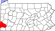
This is intended to be a complete list of the official state historical markers placed in Washington County, Pennsylvania
Washington County, Pennsylvania
-Government and politics:As of November 2008, there are 152,534 registered voters in Washington County .* Democratic: 89,027 * Republican: 49,025 * Other Parties: 14,482...
by the Pennsylvania Historical and Museum Commission
Pennsylvania Historical and Museum Commission
The Pennsylvania Historical and Museum Commission is the governmental agency of the Commonwealth of Pennsylvania responsible for the collection, conservation and interpretation of Pennsylvania's historic heritage...
(PHMC). The locations of the historical markers, as well as the latitude and longitude coordinates as provided by the PHMC's database, are included below when available. There are 51 historical markers located in Washington County.
Historical markers
| Marker title | Image | Date dedicated | Location | Marker type | Topics |
|---|---|---|---|---|---|
| Declaration and Address Declaration and address The Declaration and Address was written by Thomas Campbell in 1809. It was the founding document for the Christian Association of Washington, a short lived religious movement of the 19th century. The Christian Association ultimately led to what is now known as the Restoration Movement. In many... |
122 S. Main St., Washington 40.16905°N 80.24487°W |
City | Religion | ||
| S Bridge Claysville S Bridge The Claysville "S" Bridge is a historic S bridge in Washington County, Pennsylvania.It is designated as a historic bridge by the Washington County History & Landmarks Foundation.... |
U.S. 40, at Pa. 221, 5 miles SW of Washington 40.1398°N 80.3491°W |
Roadside | Bridges, Roads, Transportation | ||
| 1948 Donora Smog | Meldon Ave. (Pa. 837) at Fifth St., Donora 40.1763°N 79.85538°W |
Roadside | Environment | ||
| Augusta Town | U.S. 40, 3 miles SW of Washington °N °W |
Roadside | Government & Politics, Government & Politics 18th Century | ||
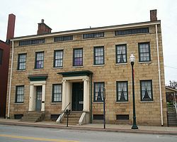
| Bradford House David Bradford House David Bradford House, in Washington, Pennsylvania was the home of David Bradford, a leader of the Whiskey Rebellion.It is designated as a historic public landmark by the Washington County History & Landmarks Foundation.-History:... |
175 S. Main St., Washington 40.16813°N 80.24475°W |
City | Buildings, Houses & Homesteads, Military, Whiskey Rebellion | ||
| Bradford House David Bradford House David Bradford House, in Washington, Pennsylvania was the home of David Bradford, a leader of the Whiskey Rebellion.It is designated as a historic public landmark by the Washington County History & Landmarks Foundation.-History:... |
At site, 175 S. Main St., Washington (retired) °N °W |
Roadside | Buildings, Houses & Homesteads, Military, Whiskey Rebellion | ||
| California Boatyards | Borough library (old railroad station), Wood St., California 40.06818°N 79.88927°W |
City | Business & Industry, Transportation | ||
| Capt. Philo McGiffin Philo McGiffen Philo Norton McGiffin was a late 19th century American naval officer later serving in Chinese service as a naval advisor during the First Sino-Japanese War... |
Main & Beau Sts., Washington 40.1707°N 80.24558°W |
Roadside | Military, Military Post-Civil War | ||
| Cement City | McKean Ave. (Pa. 837), South Donora 40.16798°N 79.86203°W |
Roadside | Business & Industry, Labor | ||
| Col. George Morgan George Morgan (merchant) George Morgan was a merchant, land speculator, and United States Indian agent during the American Revolutionary War, when he was given the rank of colonel. He negotiated with Lenape and other Native American tribes in western Pennsylvania to gain their support for the Americans during the war... |
Morganza Road and West McMurray Road, Canonsburg 40.27352°N 80.15832°W |
Roadside | Government & Politics, Government & Politics 19th Century, Native American, Professions & Vocations | ||
| Cross Creek Church | SR 4029 at Cross Creek, E of Pa. 18 °N °W |
Roadside | Ethnic & Immigration, Religion | ||
| David Reed | Pa. 50, 3 miles west of Pa. 980, near Venice 40.31485°N 80.2692°W |
Roadside | Early Settlement, Ethnic & Immigration, George Washington | ||
| Delvin Miller | Entrance to the Meadows Racetrack & Casino, 210 Racetrack Rd., Washington °N °W |
Roadside | Sports | ||
| Doddridge's Fort | Pa. 844 west of Pa. 231 at Sugar Run Road, 2.5 miles W of Middletown °N °W |
Roadside | American Revolution, Military | ||
| Edward Acheson Edward Goodrich Acheson Edward Goodrich Acheson was an American chemist. Born in Washington, Pennsylvania, he was the inventor of carborundum, and later a manufacturer of carborundum and graphite. Thomas Edison put him to work on September 12, 1880 at his Menlo Park, New Jersey laboratory under John Kruesi... |
SW corner of Main & Maiden Sts., Washington 40.16773°N 80.24488°W |
City | Invention, Medicine & Science, Professions & Vocations | ||
| Elisha McCurdy | SR 4004 (old U.S. 22) near Pa. 18, Florence 40.43207°N 80.4359°W |
Roadside | Religion | ||
| Gantz Oil Well | W. Chestnut St. at Brookside Ave., Washington °N °W |
City | Business & Industry, Oil & Gas | ||
| George Washington George Washington George Washington was the dominant military and political leader of the new United States of America from 1775 to 1799. He led the American victory over Great Britain in the American Revolutionary War as commander-in-chief of the Continental Army from 1775 to 1783, and presided over the writing of... |
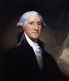 |
Southview Rd., N of PA 150, Venice 40.3252°N 80.2697°W |
Roadside | Early Settlement, George Washington, Government & Politics, Government & Politics 18th Century | |
| Globe Inn | 155 S. Main St., Washington °N °W |
City | Buildings, Business & Industry, Roads, Inns & Taverns | ||
| Hill Church | U.S. 19, 5 miles NE of Washington (Missing) °N °W |
Roadside | Buildings, Early Settlement, Religion | ||
| Hill's Tavern Hill's Tavern Hill's Tavern is a historic building in Scenery Hill, Pennsylvania.It is designated as a historic public landmark by the Washington County History & Landmarks Foundation.... |
U.S. 40 and Fava Farm Rd., Scenery Hill °N °W |
Roadside | Buildings, Business & Industry, Roads, Inns & Taverns | ||
| James G. Blaine James G. Blaine James Gillespie Blaine was a U.S. Representative, Speaker of the United States House of Representatives, U.S. Senator from Maine, two-time Secretary of State... |
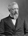 |
238 Main St., West Brownsville °N °W |
Roadside | Government & Politics, Government & Politics 19th Century | |
| Jay Livingston Jay Livingston Jay Livingston was an American composer and singer best known as half of a songwriting duo with Ray Evans that specialized in songs composed for films. Livingston wrote the music and Evans the lyrics.... |
Rt. 980 (S. McDonald St.) and Panhandle Trail, McDonald 40.36663°N 80.23478°W |
Roadside | Motion Pictures & Television, Music & Theater, Writers | ||
| John K. Tener John K. Tener John Kinley Tener was a Major League baseball player and executive and, from 1911 to 1915, served as the 25th Governor of Pennsylvania.-Biography:... |
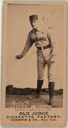 |
7th & Fallowfield Sts., Charleroi °N °W |
Roadside | Baseball, Ethnic & Immigration, Government & Politics, Governors, Sports | |
| John McMillan John McMillan (pastor) John McMillan was a prominent Presbyterian minister and missionary in Western Pennsylvania when that area was part of the American Frontier. He founded the first school west of the Allegheny Mountains, which is now known as John McMillan's Log School... |
US 19 near Rt. 519, S of Canonsburg 40.24192°N 80.17808°W |
Roadside | Education, Religion | ||
| Joseph Yablonski Joseph Yablonski Joseph Albert "Jock" Yablonski was an American labor leader in the United Mine Workers in the 1950s and 1960s. He was murdered in 1969 by killers hired by a union political opponent, Mine Workers president W. A. Boyle... |
3rd & Wood Sts., California 40.06662°N 79.88982°W |
Roadside | Coal, Government & Politics 20th Century, Labor | ||
| LeMoyne Crematory LeMoyne Crematory The LeMoyne Crematory was the first crematory in the United States. Francis Julius LeMoyne had it built in 1876, with the first cremation in world history being preformed on December 6, 1876.... |
Opposite 815 S. Main St. (SR 2001), S end of Washington 40.16057°N 80.23785°W |
City | Buildings, Business & Industry | ||
| LeMoyne House F. Julius Lemoyne House F. Julius LeMoyne House is Georgian-style house built in 1812.It was declared a National Historic Landmark in 1997.The house is operated as a historic house museum by the Washington County Historical Society, which offers guided tours year round. The house contains period artifacts and is... |
 |
49 E. Maiden St., Washington 40.16798°N 80.24327°W |
City | Buildings, Houses & Homesteads, Medicine & Science, Professions & Vocations | |
| The McGugin Gas Well | Pa. 18 NW of Washington (Missing) °N °W |
Roadside | Business & Industry, Oil & Gas | ||
| Meadowcroft Rockshelter | 401 Meadowcroft Rd., Avella 40.28635°N 80.489°W |
Roadside | Native American | ||
| Miller's Blockhouse | U.S. 40, 3.5 miles W of Claysville °N °W |
Roadside | American Revolution, Early Settlement, Forts, Military, Native American | ||
| Mingo Creek Church Mingo Creek Presbyterian Church and Churchyard Mingo Creek Presbyterian Church and Churchyard is a historic church in Courtney, Pennsylvania.It was built in 1793 and added to the National Register of Historic Places in 1992.... |
SR 88 & Mingo Church Rd., 2 miles S of Finleyville 40.23015°N 79.99583°W |
Roadside | Military, Religion, Whiskey Rebellion | ||
| Monongahela Monongahela, Pennsylvania Monongahela, colloquially called "Mon City," is a Third Class City in Washington County, Pennsylvania, United States and is part of the Pittsburgh Metro Area, located approximately south of the city proper. The population was 4,761 at the 2000 census... |
Pa. 136 at the Monogahela River Bridge (Missing) °N °W |
Roadside | Cities & Towns, Early Settlement, Transportation | ||
| Monongahela Monongahela, Pennsylvania Monongahela, colloquially called "Mon City," is a Third Class City in Washington County, Pennsylvania, United States and is part of the Pittsburgh Metro Area, located approximately south of the city proper. The population was 4,761 at the 2000 census... |
Pa. 136 at Chess St., in small park 40.20608°N 79.93975°W |
Roadside | Cities & Towns, Early Settlement, Transportation | ||
| Monongahela Monongahela, Pennsylvania Monongahela, colloquially called "Mon City," is a Third Class City in Washington County, Pennsylvania, United States and is part of the Pittsburgh Metro Area, located approximately south of the city proper. The population was 4,761 at the 2000 census... |
Main Street (Pa. 88) at 5th St. at Municipal Building, Monongahela 40.2039°N 79.92763°W |
Roadside | Cities & Towns, Early Settlement, Transportation | ||
| Monongahela Monongahela, Pennsylvania Monongahela, colloquially called "Mon City," is a Third Class City in Washington County, Pennsylvania, United States and is part of the Pittsburgh Metro Area, located approximately south of the city proper. The population was 4,761 at the 2000 census... |
Pa. 88 at 7th St., in Monongahela's Chess Park 40.2049°N 79.93118°W |
Roadside | Cities & Towns, Early Settlement, Transportation | ||
| The Mounds | Memorial Park, Mounds & Indiana Sts., Monongahela 40.19855°N 79.93258°W |
City | Native American | ||
| National Road National Road The National Road or Cumberland Road was the first major improved highway in the United States to be built by the federal government. Construction began heading west in 1811 at Cumberland, Maryland, on the Potomac River. It crossed the Allegheny Mountains and southwestern Pennsylvania, reaching... |
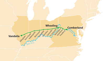 |
U.S. 40, 3.6 miles SW of Washington 40.14998°N 80.32803°W |
Roadside | Government & Politics, Roads, Transportation | |
| Ralston Thresher | Pa. 844 at West Middletown °N °W |
Roadside | Agriculture, Business & Industry, Invention | ||
| Reverend John McMillan John McMillan (pastor) John McMillan was a prominent Presbyterian minister and missionary in Western Pennsylvania when that area was part of the American Frontier. He founded the first school west of the Allegheny Mountains, which is now known as John McMillan's Log School... |
n/a | Junction US 19 & PA 519, S of Canonsburg 40.24202°N 80.17797°W |
Plaque | Education, Religion | |
| Rice's Fort | U.S. 40 at Lake Road, 3.5 miles W of Claysville °N °W |
Roadside | American Revolution, Forts, Military, Native American | ||
| Toll House | U.S. 40, .8 mile W of Claysville (Missing) °N °W |
Roadside | Government & Politics 19th Century, Roads, Transportation | ||
| Washington Washington, Pennsylvania Washington is a city in and the county seat of Washington County, Pennsylvania, United States, within the Pittsburgh Metro Area in the southwestern part of the state... |
Murtland Ave. (US 19) at North Ave., NE edge of Washington 40.18047°N 80.23575°W |
Roadside | Cities & Towns, George Washington, Native American, Roads | ||
| Washington Washington, Pennsylvania Washington is a city in and the county seat of Washington County, Pennsylvania, United States, within the Pittsburgh Metro Area in the southwestern part of the state... |
US 40 W on ramp at junction of I-70 (Missing) °N °W |
Roadside | Cities & Towns, George Washington, Native American, Roads | ||
| Washington Washington, Pennsylvania Washington is a city in and the county seat of Washington County, Pennsylvania, United States, within the Pittsburgh Metro Area in the southwestern part of the state... |
 |
National Rd. (US 40) near Coffeys Crossing Rd (Rt. 526), W of Washington, near Finney 40.15002°N 80.32797°W |
Roadside | Cities & Towns, George Washington, Native American, Roads | |
| Washington Washington, Pennsylvania Washington is a city in and the county seat of Washington County, Pennsylvania, United States, within the Pittsburgh Metro Area in the southwestern part of the state... |
Pa. 136, E. Beau St. @ Clare Dr., near Junction of I70 and I79 °N °W |
Roadside | Buildings, Cities & Towns, Early Settlement, George Washington, Native American, Transportation | ||
| Washington and Jefferson College Washington & Jefferson College Washington & Jefferson College, also known as W & J College or W&J, is a private liberal arts college in Washington, Pennsylvania, in the United States, which is south of Pittsburgh... |
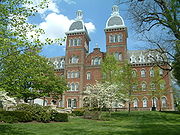 |
At main building, opposite 27 College Ave., and Beau St. between College and Lincoln, Washington 40.1705°N 80.2426°W |
City | Education, George Washington | |
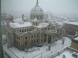
| Washington County Washington County, Pennsylvania -Government and politics:As of November 2008, there are 152,534 registered voters in Washington County .* Democratic: 89,027 * Republican: 49,025 * Other Parties: 14,482... |
County courthouse, Main St. & Cherry Way, Washington 40.17015°N 80.24538°W |
City | George Washington, Government & Politics, Government & Politics 18th Century, Military, Roads, Whiskey Rebellion | ||
| Whiskey Point | Main St. (PA 136/88/837) betw. First St. & Park Ave., Monongahela 40.20015°N 79.92258°W |
Roadside | Government & Politics, Government & Politics 18th Century, Military, Whiskey Rebellion | ||
| William Holmes McGuffey William Holmes McGuffey William Holmes McGuffey was an American professor and college president who is best known for writing the McGuffey Readers, one of the nation's first and most widely used series of textbooks... |
U.S. 40 at McGuffey High School McGuffey High School McGuffey High School is one of four schools that make up the McGuffey School District in rural Claysville, Pennsylvania. The school is approximately 30 miles southwest of Pittsburgh, Pennsylvania. The school's official colors are navy blue and gold and "Highlanders" has been adopted as the official... /Middle School McGuffey Middle School McGuffey Middle School is one of four schools that make up the McGuffey School District in rural Claysville, Pennsylvania.The school is approximately 30 miles southwest of Pittsburgh, Pennsylvania.Like the high school their official colors are navy blue and gold and "Highlanders" has been adopted... , just W of Pa. 221, E of Claysville °N °W |
Roadside | Education, Professions & Vocations, Publishing, Writers | ||
| Wolff's Fort | U.S. 40, 3.3 miles SW of Washington °N °W |
Roadside | American Revolution, Early Settlement, Forts, Military |
See also
- List of Pennsylvania state historical markers
- National Register of Historic Places listings in Washington County, Pennsylvania
- Washington County History & Landmarks FoundationWashington County History & Landmarks FoundationWashington County History & Landmarks Foundation is a non-profit educational institution in Washington, Pennsylvania. Its purpose is to encourage and assist the preservation of historic structures in Washington County, Pennsylvania...